


Alamogordo, New Mexico
Alamogordo is a city of 31,307 people in Otero County, New Mexico, founded in 1898.
Why visit Alamogordo
Townapedia lists 22 museums and landmarks, 25 parks and trails, 60 places to eat, 18 places to stay and 5 attractions in and around town.
Highlights include Alameda Park Zoo, Flickinger Center for Performing Arts, New Mexico Museum of Space History and Administration Building.
June is the warmest month, with average highs of 94°F; December lows average 33°F.
Weather in Alamogordo
Forecast from the National Weather Service. Full forecast
About Alamogordo
Alamogordo () is a city in and the county seat of Otero County, New Mexico, United States. A city in the Tularosa Basin of the Chihuahuan Desert, it is bordered on the east by the Sacramento Mountains and to the west by Holloman Air Force Base. The population was 31,384 as of the 2020 census. Alamogordo is widely known for its connection with the 1945 Trinity test, which was the first-ever explosion of an atomic bomb.
From the Wikipedia article Alamogordo, New Mexico (this version), under CC BY-SA 4.0.
Things to do5

Alameda Park Zoo
Zoo and aquarium · 1.3 mi
Zoo in Alamogordo, New Mexico United States
1376 East 9th Street, Alamogordo
09:00-17:00; Dec 25 off; Jan 01 off

Flickinger Center for Performing Arts
Cinema and theater · 1.3 mi
Theater and former movie theater in Alamogordo, New Mexico, United States
1110 New York Avenue, Alamogordo

New Mexico State University Alamogordo
School · 3.3 mi
Public community college in Alamogordo, New Mexico
2400 North Scenic Drive, Alamogordo

Museums and landmarks22


Administration Building
Monument and historic site · National Register of Historic Places · 2.1 mi
United States historic place

Alamogordo Woman's Club
Monument and historic site · National Register of Historic Places · 1.3 mi
American women's club

Central Receiving Building
Monument and historic site · National Register of Historic Places · 2.1 mi
University building in Alamogordo, New Mexico
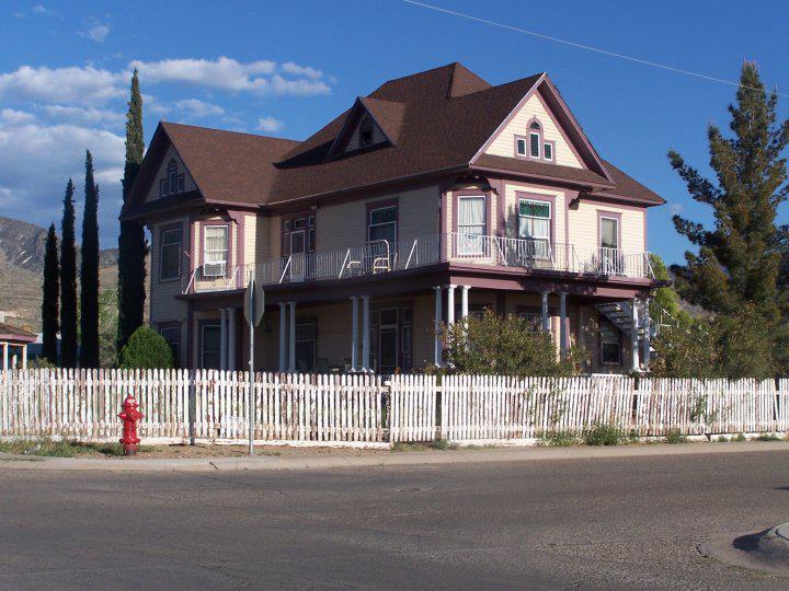
Jackson House
Monument and historic site · National Register of Historic Places · 1.7 mi
Historic house in New Mexico, United States
Tularosa Basin Museum of History
Museum · 1.2 mi
1004 North White Sands Boulevard, Alamogordo
Mo-Sa 10:00-16:00

Harry Francis Acley House Historic Site
Monument and historic site · 1.3 mi
1115 Indiana Avenue, Alamogordo
10 more on the map.
Parks, trails and playgrounds25





13 more on the map.
Restaurants and cafes60

Applebee's
Diner · American · 0.5 mi
1355 South While Sands Boulevard, Alamogordo
Mo-Th 11:00-24:00, Fr-Sa 11:00-01:00, Su 11:00-24:00

Asian Garden
Restaurant · Asian · 1.3 mi
1200 North White Sands Boulevard, Alamogordo
Tu-Fr 11:00-14:30, 16:30-21:00; Sa-Su 11:00-21:00
Buffalo Wild Wings
Restaurant · Wings
839 South White Sands Boulevard, Alamogordo
Mo-Th 11:00-24:00, Fr-Sa 11:00-02:00, Su 11:00-24:00
Carino's
Restaurant · Italian · 0.6 mi
260 Panaroma Boulevard, Alamogordo
Mo-Fr 11:00-22:00; Sa-Su 11:00-23:00
Chili's
Restaurant · Tex-Mex · 0.6 mi
202 Panaroma Boulevard, Alamogordo
Mo-We 11:00-22:00; Fr 11:00-24:00; Sa 11:00-23:00; Su 11:00-22:00
Hi-D-Ho Drive In
Restaurant
A drive-in restaurant specializing in burgers.
414 South White Sands Blvd.
Tu, We 10:00-19:00; Mo, Th, Su 10:00-20:30; Fr, Sa 10:00-21:00
Just Pho You
Restaurant · Vietnamese · 2.7 mi
2617 North White Sands Boulevard, Alamogordo
Mo-Su 11:00-19:30
Pizza Hut
Restaurant · Pizza
615 South While Sands Boulevard, Alamogordo
Mo-Th 11:00-22:00; Fr-Sa 11:00-23:00; Su 11:00-22:00
48 more on the map.
History
Tularosa Basin has been inhabited for at least 11,000 years. There are signs of previous inhabitants in the area such as the Clovis culture, the Folsom culture, the peoples of the Archaic period, and the Formative stage. The Mescalero Apache were already living in the Tularosa Basin when the Spanish came in 1534, and Mescalero oral history says they have always lived there. In 1719, the Spanish built a chapel at La Luz (about 5 miles (8.0 km) from the future site of Alamogordo), although La Luz was not settled until about 1860.
The city of Alamogordo was founded in June 1898, when the El Paso and Northeastern Railroad, headed by Charles Bishop Eddy, extended the railway to the town. Eddy influenced the design of the community, which included large, wide thoroughfares and tree-lined irrigation canals. Charles Eddy's brother, John Arthur Eddy, named the new city. He created a neologism adapted from the Spanish words for "large/fat cottonwood" after a grove of stout cottonwoods he remembered from the Pecos River area. However, the word "Alamogordo" was not used in the Spanish language. When Alamogordo was laid out in 1898, the east–west streets were given numerical designations, while north–south streets were named after states. The present-day White Sands Boulevard was then called Pennsylvania Avenue.
With the creation of White Sands National Monument in 1934, tourism began.
From the History section of Alamogordo, New Mexico on Wikipedia, under CC BY-SA 4.0.
Where to stay18
Churches and places of worship10
Immaculate Conception Catholic Church
Church · Roman Catholic · 1.0 mi
705 Delaware Avenue, Alamogordo
First Presbyterian Church
Church · Presbyterian · 1.8 mi
1318 14th Street, Alamogordo
Our Saviour Lutheran Church
Church · Lutheran · 1.8 mi
1212 Washington Avenue, Alamogordo
Shopping16
Gas and EV charging17
Schools, colleges and libraries32
New Mexico School for the Blind and Visually Impaired
School · 2.0 mi
100 North White Sands Boulevard, Alamogordo
Nm School For The Blind And Visually Impaired
School · 2.1 mi
1900 North White Sands, Alamogordo
Healthcare4
Southern New Mexico Wellness Alliance Doctor's Office
Clinic and pharmacy · 1.8 mi
1410 Aspen Drive
Map of Alamogordo
209 places. The map loads OpenStreetMap tiles when you open it.
Climate by month
Monthly table
| Month | High | Low | Rain | Snow |
|---|---|---|---|---|
| Jan | 55°F | 33°F | 0.7 in | 1.0 in |
| Feb | 60°F | 37°F | 0.6 in | 0.1 in |
| Mar | 68°F | 43°F | 0.3 in | 0.2 in |
| Apr | 76°F | 50°F | 0.3 in | 0.0 in |
| May | 85°F | 59°F | 0.5 in | 0.0 in |
| Jun | 94°F | 68°F | 0.6 in | 0.0 in |
| Jul | 93°F | 70°F | 1.6 in | 0.0 in |
| Aug | 91°F | 68°F | 2.0 in | 0.0 in |
| Sep | 86°F | 63°F | 1.5 in | 0.0 in |
| Oct | 75°F | 51°F | 1.0 in | 0.1 in |
| Nov | 64°F | 41°F | 0.6 in | 0.1 in |
| Dec | 54°F | 33°F | 1.1 in | 0.9 in |
U.S. Climate Normals 1991-2020 for Alamogordo (2 mi away), NOAA NCEI.
People and cost of living
American Community Survey 5-year estimates, 2020-2024, U.S. Census Bureau. Estimates have margins of error, larger for small towns.
Disaster history
Otero County has had 23 federal disaster declarations since 2000, most often for fires.
- 2025-07-22: Severe Storms, Flooding, And Landslides (Flood)
- 2025-07-10: Severe Storms, Flooding, And Landslides (Flood)
- 2024-06-20: South Fork Fire, Salt Fire, And Flooding (Fire)
- 2024-06-18: Salt Fire (Fire)
- 2024-06-17: South Fork Fire (Fire)
- 2020-04-05: Covid-19 Pandemic (Biological)
OpenFEMA disaster declarations summaries.
Getting there and nearby towns
Alamogordo-White Sands Regional Airport (ALM) is the nearest airport with scheduled flights listed in OpenStreetMap, 4 miles away.
- Boles Acres 4 mi south, about 7 min by car
- La Luz 6 mi north, about 10 min by car
- Holloman AFB 8 mi west, about 13 min by car
- High Rolls 10 mi east, about 16 min by car
- Tularosa 14 mi north, about 22 min by car
- Cloudcroft 14 mi east, about 23 min by car
- Twin Forks 19 mi east, about 30 min by car
- Mescalero 20 mi northeast, about 32 min by car
- Timberon 23 mi southeast, about 37 min by car
- Ruidoso 36 mi northeast, about 59 min by car
Drive times are estimates from straight-line distance, not routes.
Local news
Headlines from INDB, the NEMICO news database.
Reviews, tips and questions
Loading what members have shared...
Sources and licences
- NCES EDGE (Public domain): public schools
- NOAA NCEI U.S. Climate Normals 1991-2020 (Public domain): climate by month
- OpenFEMA (Public domain): disaster declarations
- OpenStreetMap contributors (ODbL 1.0): places, airports, map data
- U.S. Census Bureau (Public domain): population, income, housing, education, commute
- Wikidata (CC0 1.0): elevation, founding date, time zone, website, landmarks and historic places
- Wikimedia Commons (see each image): photos
- Wikipedia (CC BY-SA 4.0): overview and history text
Photo credits
- View from Thunder Rd, Foreverstocks, CC BY-SA 4.0
- A Caboose At The Toy Train Depot in Alamogordo, New Mexico, D&RG Railfan, CC BY 3.0
- Sunrise Over Alamogordo, NM - panoramio, AudreyIski, CC BY-SA 3.0
- Greetings from Alamogordo, New Mexico - Large Letter Postcard (4237512182), Steve Shook from Moscow, Idaho, USA, CC BY 2.0
- This is the solar furnace apparatus operated for the U.S. Army at White Sands Mssile Range, Alamogordo, New Mexico..., 04-1974 (6919906260), The U.S. National Archives, No restrictions
- The solar furnace operated for the U.S. Army at White Sands Mssile Range, Alamogordo, New Mexico..., 04-1974 (7065985431), The U.S. National Archives, No restrictions
- The solar furnace at White Sands Missile Range, Alamogordo New Mexico. Operated for the U.S. Army..., 04-1974 (7065984695), The U.S. National Archives, No restrictions
- A view into the test cab during a test of the solar furnace operated for the U.S. Army at White Sands Missile Range Alamogordo, New Mexico..., 04-1974 (6919908132), The U.S. National Archives, No restrictions
- Engineers inside the test cab of the solar furnace facility operated for the U.S. Army at White Sands Missile Range Alamogordo, New Mexico..., 04-1974 (6919911730), The U.S. National Archives, No restrictions
- Stadium Home of Alamogordo Tigers - panoramio (1), AudreyIski, CC BY-SA 3.0
- Stadium Home of Alamogordo Tigers - panoramio, AudreyIski, CC BY-SA 3.0
- Welcome to Alamogordo - panoramio, AudreyIski, CC BY-SA 3.0
- Greetings from Alamogordo, New Mexico - Large Letter Postcard (20475859762), Steve Shook from Moscow, Idaho, USA, CC BY 2.0
- Alamogordo City Hall, AllenS, Public domain
- Beautiful Homes in Alamogordo - panoramio, AudreyIski, CC BY-SA 3.0
- Alamogordo - Saint Jude mission - 2, This illustration was made by Peter Potrowl . Please credit this with : © Peter Potrowl in the immediate vicinity of the image. A link to my website sitemai.eu would be much appreciated but isn't..., CC BY-SA 3.0
- Alamogordo - Saint Jude mission - 6, This illustration was made by Peter Potrowl . Please credit this with : © Peter Potrowl in the immediate vicinity of the image. A link to my website sitemai.eu would be much appreciated but isn't..., CC BY-SA 3.0
- Alamogordo - Saint Jude mission - 1, This illustration was made by Peter Potrowl . Please credit this with : © Peter Potrowl in the immediate vicinity of the image. A link to my website sitemai.eu would be much appreciated but isn't..., CC BY-SA 3.0
- Alamogordo - Saint Jude mission - 4, This illustration was made by Peter Potrowl . Please credit this with : © Peter Potrowl in the immediate vicinity of the image. A link to my website sitemai.eu would be much appreciated but isn't..., CC BY-SA 3.0
- Alamogordo - Saint Jude mission - 8, This illustration was made by Peter Potrowl . Please credit this with : © Peter Potrowl in the immediate vicinity of the image. A link to my website sitemai.eu would be much appreciated but isn't..., CC BY-SA 3.0
- Alamogordo - Saint Jude mission - 5, This illustration was made by Peter Potrowl . Please credit this with : © Peter Potrowl in the immediate vicinity of the image. A link to my website sitemai.eu would be much appreciated but isn't..., CC BY-SA 3.0
- Alamogordo - Saint Jude mission - 7, This illustration was made by Peter Potrowl . Please credit this with : © Peter Potrowl in the immediate vicinity of the image. A link to my website sitemai.eu would be much appreciated but isn't..., CC BY-SA 3.0
- Alamogordo Flickinger box office, AllenS, Public domain
- Alamogordo Woman's Club building, AllenS, Public domain
- Jackson House Alamogordo NM, Jtjones6, CC0
- New Mexico School for the Blind Tapia building, AllenS, Public domain
- New Mexico School for the Blind Central Receiving building, AllenS, Public domain
- Only Wal-Mart within a 70 mile radius - panoramio, AudreyIski, CC BY-SA 3.0
- View of the parabolic reflectors and test cab (extreme right) of the solar furnace apparatus operated for the U.S. Army at the White Sands Missile Range, 04-1974. (6919946092), The U.S. National Archives, No restrictions
- This is a heliostat, a plane surface consisting of many flat mirrors, about 60 feet tall which is part of the solar furnace..., 04-1974 (7065986079), The U.S. National Archives, No restrictions
- This parabolic mirror system is part of the solar furnace operated for the U.S. Army..., 04-1974. (6919950916), The U.S. National Archives, No restrictions
- One quarter inch thick aluminum plate melted by the sun's rays in the solar furnace..., 04-1974 (7065992865), The U.S. National Archives, No restrictions
- Looking up from ground level at the 60-foot-high expanse that makes up the parabolic mirror system of the solar furnace..., 04-1974 (6919907436), The U.S. National Archives, No restrictions
- Looking at the test cab where the sun's rays are focused in the intense white spot of the solar furnace..., 04-1974 (7065991117), The U.S. National Archives, No restrictions
- Joe Lewandoski giving a tour, Leitenightwiki, CC0
- Ramblin Around - panoramio, AudreyIski, CC BY-SA 3.0
- Alameda Park Zoo (6918187423), timlewisnm, CC BY-SA 2.0
- Mountain Lion, Olivia Danielle Ruiz, CC BY-SA 4.0
- 10th , westbound - panoramio, AudreyIski, CC BY-SA 3.0
- 12th and Iowa AVE - panoramio, AudreyIski, CC BY-SA 3.0


Page built October 30, 2026. Spotted a mistake? Tell us or suggest a place.