
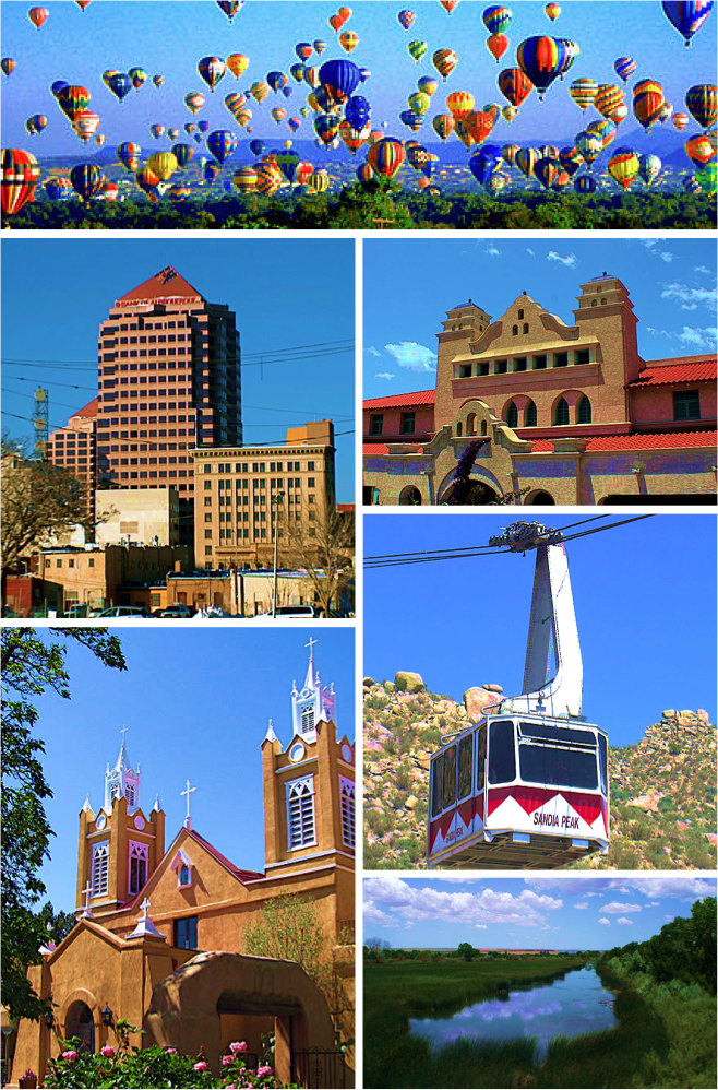


Albuquerque, New Mexico
Albuquerque is a city of 562,218 people in Bernalillo County, New Mexico, founded in 1706.
Why visit Albuquerque
Townapedia lists 160 museums and landmarks, 42 parks and trails, 229 places to eat, 44 places to stay and 17 attractions in and around town.
Highlights include Albuquerque Aquarium, Sunshine Theatre, Indian Pueblo Cultural Center and Jonson Gallery.
July is the warmest month, with average highs of 95°F; December lows average 21°F.
Weather in Albuquerque
Forecast from the National Weather Service. Full forecast
About Albuquerque
Albuquerque is the most populous city in the U.S. state of New Mexico. Founded in 1706 as La Villa de Alburquerque by Santa Fe de Nuevo México governor Francisco Cuervo y Valdés, and named in honor of Francisco Fernández de la Cueva, 10th Duke of Alburquerque and Viceroy of New Spain, it was an outpost on El Camino Real, linking Mexico City to the northernmost territories of New Spain. It is the county seat of Bernalillo County.
From the Wikipedia article Albuquerque, New Mexico (this version), under CC BY-SA 4.0.
Things to do17

Albuquerque Aquarium
Zoo and aquarium · 2.0 mi
09:00-17:00;"extended to 6 p.m. on Saturdays and Sundays during the summer"

Isleta Amphitheater
Cinema and theater · 7.4 mi
Outdoor theater in Albuquerque, New Mexico
Albuquerque Little Theatre
Cinema and theater · 1.6 mi
224 San Pasquale Avenue Southwest, Albuquerque
El Rey Theater
Cinema and theater · 1.5 mi
622 Central Avenue Northwest, Albuquerque
Kimo Theater Historic Site
Cinema and theater · 1.4 mi
423 Central Avenue Northwest, Albuquerque
Al Hurricane Pavilion
Cinema and theater · 1.2 mi
Concert and event stage named after Al Hurricane, the Godfather of New Mexico music.
Dry Heat Comedy Club
Cinema and theater · 1.4 mi
521 Central Avenue Northwest, Albuquerque
5 more on the map.
Museums and landmarks160


Jonson Gallery
Monument and historic site · National Register of Historic Places · 1.9 mi
Historic building on the campus of the University of New Mexico in Albuquerque, New Mexico, USA
1909 Las Lomas Road Northeast

J.R. Willis House and La Miradora Apartments
Monument and historic site · National Register of Historic Places · 1.6 mi
Historic building complex in Albuquerque, New Mexico
New Mexico Holocaust Museum and Gellert Center for Education
Museum · 1.5 mi
616 Central Avenue Northwest
We-Su 12:00-15:00

Skinner Building
Monument and historic site · National Register of Historic Places · 1.5 mi
Listed on the National Register of Historic Places in Bernalillo County, New Mexico
722 Central Avenue Northwest, Albuquerque

Sunshine Building
Monument and historic site · National Register of Historic Places · 1.4 mi
Commercial building, music venue and former movie theater in Albuquerque, New Mexico, Uniter States
120 Central Avenue Northwest, Albuquerque


Zimmerman Library
Monument and historic site · National Register of Historic Places · 2.0 mi
Historic building in New Mexico, United States
1900 Roma Avenue Northeast, Albuquerque
Albuquerque Veterans Administration Medical Center
Monument and historic site · National Register of Historic Places · 5.0 mi
Veterans Administration hospital in Albuquerque, New Mexico, United States
Aldo Leopold Neighborhood Historic District
Monument and historic site · National Register of Historic Places · 1.5 mi
Historic district in Albuquerque, New Mexico
Antonio Vigil House
Monument and historic site · National Register of Historic Places · 1.4 mi
Historic house in New Mexico, United States
Art Annex
Monument and historic site · National Register of Historic Places · 2.0 mi
Historic building on the campus of the University of New Mexico in Albuquerque, New Mexico
AT&SF Freight Office
Monument and historic site · National Register of Historic Places · 1.6 mi
Building in New Mexico, United States of America
148 more on the map.
Parks, trails and playgrounds42

Tingley Field
Park · 1.9 mi
550 10th Street Southwest, Albuquerque
sunrise-sunset

University of New Mexico North Golf Course
Golf course · 1.6 mi
9 hole Par 36
2201 Tucker Avenue Northeast, Albuquerque

Urban Air Trampoline and Adventure Park
Playground · 1.8 mi
If you are looking for the best year-round indoor amusements in Rio Rancho, Bernalillo, South Valley, Santa Fe, Los Lunas and...
3930 Pan American Freeway Northeast, Albuquerque
30 more on the map.
Restaurants and cafes229

Duran's Central Pharmacy
Restaurant · New Mexican, Mexican · 1.4 mi
1815 Central Avenue Northwest, Albuquerque
Mo-Tu 09:00-18:30; We-Su 09:00-20:00

Central Grill and Coffeehouse
Restaurant · American, Coffee Shop, Burger, Breakfast · 1.5 mi
2056 Central Avenue Southwest, Albuquerque
Mo-Su 07:00-14:00

Cutbow Coffee Roastology
Cafe · Coffee Shop · 1.4 mi
1208 Rio Grande Boulevard Northwest
Tu-Fr 07:30-15:00; Sa-Su 08:00-15:00
Good Medicine Tattoo
Cafe · Coffee Shop · 1.4 mi
1115 Central Avenue Northwest, Albuquerque
We-Su 12:00-19:00
Lost Cultures
Cafe · Tea · 1.0 mi
1761 Bellahmah Avenue NW, Albuquerque
Mo-Tu 11:00-21:00; We-Th 15:00-21:00; Fr-Sa 11:00-22:00; Su 11:00-20:00
Madcrema
Cafe · Coffee Shop · 0.8 mi
1108 Broadway Boulevard Northeast, Albuquerque
Tu-Fr 07:00-14:00; Sa-Su 08:00-14:00
Oni
Restaurant · Noodle, Ramen, Regional · 1.4 mi
600 Central Ave SW, Albuquerque
Tu-Th 11:30-20:00; Fr-Sa 11:30-21:00
Pizza 9
Restaurant · Pizza · 1.5 mi
101 Gold Ave SW, Albuquerque
Mo-Th 09:00-23:00; Fr 09:00-24:00; Sa 10:00-24:00; Su 10:00-23:00
217 more on the map.
Where to stay44
Best Western Plus Rio Grande Inn
Motel and hotel · 1.4 mi
1015 Rio Grande Boulevard Northwest, Albuquerque
Days Inn by Wyndham Albuquerque Downtown
Motel and hotel · 1.5 mi
615 Central Avenue Northeast, Albuquerque
DoubleTree by Hilton Hotel Albuquerque
Motel and hotel · 1.1 mi
201 Marquette Avenue Northwest, Albuquerque
Home2 Suites by Hilton Albuquerque/Downtown-University
Motel and hotel · 1.1 mi
1660 University Boulevard Northeast, Albuquerque
Hotel Andaluz
Motel and hotel · 1.4 mi
125 2nd Street Northwest, Albuquerque
Churches and places of worship22
San Felipe de Neri Catholic Church
Church · Roman Catholic · 1.4 mi
2005 North Plaza Street Northwest, Albuquerque
San Ignacio Catholic Church
Church · Roman Catholic · 0.8 mi
1300 Walter Street Northeast, Albuquerque
First United Methodist Church
Church · United Methodist · 1.7 mi
315 Coal Avenue Southwest
Immaculate Conception Catholic Church
Church · Roman Catholic · 1.4 mi
619 Copper Avenue Northwest, Albuquerque
Saint Therese of the Infant Jesus Catholic Church
Church · Roman Catholic · 0.9 mi
3424 4th Street Northwest, Albuquerque
Saint Thomas Aquinas University Parish
Church · Roman Catholic · 1.8 mi
1815 Las Lomas Road Northeast, Albuquerque
Saint George Greek Orthodox Church
Church · Greek Orthodox · 1.7 mi
308 High Street Southeast, Albuquerque
Shopping32
DG's Deli
Shop · 1.7 mi
1418 Doctor Martin Luther King Junior Avenue Northeast, Albuquerque
Gas and EV charging19
Four Winds Gas Station
Gas station · 0.7 mi
2401 12th Street Northwest, Albuquerque
Schools, colleges and libraries87
Saint Therese Catholic School
School · Roman Catholic · 1.0 mi
311 Shropshire Place Northwest, Albuquerque
San Felipe de Neri Catholic School
School · Roman Catholic · 1.4 mi
2000 Lomas Boulevard Northwest, Albuquerque
Albuquerque High School
School · 0.9 mi
800 Odelia Road Northeast, Albuquerque
Amy Biehl High School
School · 1.5 mi
123 4th Street Southwest, Albuquerque
Central Library;Albuquerque Main Library
Library · 1.3 mi
501 Copper Avenue Northwest, Albuquerque
Healthcare39
ENT and Sinus Center ABQ, PC Gerald N. Bart M.D., F.A.C.S
Clinic and pharmacy · 1.3 mi
401 Edith Boulevard Northeast
Lovelace Medical Center
Hospital · 1.3 mi
601 Doctor Martin Luther King Junior Avenue Northeast, Albuquerque
UNM Carrie Tingley Hospital
Clinic and pharmacy · 1.3 mi
1127 University Boulevard Northeast, Albuquerque
Behavioral Health Crisis Center
Clinic and pharmacy · 2.0 mi
2600 Marble Avenue Northeast, Albuquerque
Map of Albuquerque
250 places. The map loads OpenStreetMap tiles when you open it.
Climate by month
Monthly table
| Month | High | Low | Rain |
|---|---|---|---|
| Jan | 52°F | 21°F | 0.5 in |
| Feb | 58°F | 24°F | 0.5 in |
| Mar | 67°F | 31°F | 0.7 in |
| Apr | 76°F | 37°F | 0.7 in |
| May | 84°F | 45°F | 0.4 in |
| Jun | 94°F | 53°F | 0.5 in |
| Jul | 95°F | 62°F | 1.8 in |
| Aug | 92°F | 59°F | 1.6 in |
| Sep | 86°F | 50°F | 1.5 in |
| Oct | 75°F | 39°F | 1.0 in |
| Nov | 61°F | 28°F | 0.7 in |
| Dec | 50°F | 21°F | 0.6 in |
U.S. Climate Normals 1991-2020 for Rio Grande Nature Ctr (3 mi away), rain and snow from Albuquerque 1.7 Sse, NOAA NCEI.
People and cost of living
American Community Survey 5-year estimates, 2020-2024, U.S. Census Bureau. Estimates have margins of error, larger for small towns.
Disaster history
Bernalillo County has had 11 federal disaster declarations since 2000, most often for fires.
- 2020-04-05: Covid-19 Pandemic (Biological)
- 2020-03-13: Covid-19 (Biological)
- 2016-06-16: Dog Head Fire (Fire)
- 2013-09-30: Severe Storms And Flooding (Severe Storm)
- 2011-04-03: White Fire (Fire)
- 2006-06-16: Malpais Fire (Fire)
OpenFEMA disaster declarations summaries.
Getting there and nearby towns
Albuquerque International Sunport (ABQ) is the nearest airport with scheduled flights listed in OpenStreetMap, 5 miles away.
- Los Ranchos de Albuquerque 4 mi north, about 6 min by car
- North Valley 5 mi north, about 8 min by car
- Kirtland AFB 6 mi southeast, about 10 min by car
- South Valley 7 mi south, about 11 min by car
- Paradise Hills 7 mi northwest, about 12 min by car
- Corrales 9 mi north, about 15 min by car
- Sandia Heights 10 mi northeast, about 16 min by car
- Carnuel 11 mi east, about 18 min by car
- Pueblo of Sandia Village 11 mi northeast, about 18 min by car
- Rio Rancho 13 mi north, about 21 min by car
Drive times are estimates from straight-line distance, not routes.
Local news
Headlines from INDB, the NEMICO news database.
Reviews, tips and questions
Loading what members have shared...
Sources and licences
- NCES EDGE (Public domain): public schools
- NOAA NCEI U.S. Climate Normals 1991-2020 (Public domain): climate by month
- OpenFEMA (Public domain): disaster declarations
- OpenStreetMap contributors (ODbL 1.0): places, airports, map data
- U.S. Census Bureau (Public domain): population, income, housing, education, commute
- Wikidata (CC0 1.0): elevation, founding date, time zone, website, landmarks and historic places
- Wikimedia Commons (see each image): photos
- Wikipedia (CC BY-SA 4.0): overview and history text
Photo credits
- Albuquerque Infobox Photo, Danae Hurst, Asaavedra32, John Phelan, Luigi Novi crop, montage and hue/contrast changes: KingCam, CC BY-SA 3.0
- Albuquerque, New Mexico, USA (50300509308), Pom' from France, European Union, CC BY-SA 2.0
- Albuquerque, New Mexico, USA (49072522896), Pom' from France, European Union, CC BY-SA 2.0
- 2016-03-21 13 09 00 View east along Interstate 40 at Exit 159 (Interstate 25, Santa Fe, Las Cruces) in Albuquerque, New Mexico, Famartin, CC BY-SA 4.0
- 2016-03-21 13 09 01 View east along Interstate 40 at Exit 159 (Interstate 25, Santa Fe, Las Cruces) in Albuquerque, New Mexico, Famartin, CC BY-SA 4.0
- Albuquerque Indian School New Employee Dormitory, Camerafiend, CC BY-SA 3.0
- 1112 2nd Street NW, Albuquerque, New Mexico, Pete Prodoehl, CC BY 2.0
- Albuquerque, New Mexico USA - panoramio (96), MARELBU, CC BY 3.0
- Barber shop Mountain Road near Old Town Albuquerque, Beyond My Ken, CC BY-SA 4.0
- Albuquerque -- Indian Pueblo Kitchen, Jeremy Thompson, CC BY 2.0
- Albuquerque - 51400186337, Jeremy Thompson, CC BY 2.0
- Albuquerque - 51400186182, Jeremy Thompson, CC BY 2.0
- Albuquerque - 51401913490, Jeremy Thompson, CC BY 2.0
- Albuquerque, New Mexico USA - panoramio (91), MARELBU, CC BY 3.0
- Jonson Gallery and House, Albuquerque NM, John Phelan, CC BY 3.0
- J.R. Willis House and La Miradora Apartments, Upstateherd, CC BY-SA 4.0
- Capo's Ristorante Italiano (20657800723), Karen Blaha from Charlottesville, VA, CC BY-SA 2.0
- Zimmerman Library, UNM, Albuquerque NM, John Phelan, CC BY-SA 3.0
- Coronado School, Roland Penttila, CC BY-SA 3.0
- Huning Highlands Conoco Service Station, Albuquerque NM, John Phelan, CC BY 3.0
- Albuquerque Roosevelt Park, Asaavedra32, CC BY-SA 4.0
- Superintendent's House, Atlantic & Pacific Railroad Side, Kylegmaxwell, CC BY-SA 4.0
- Monte Vista Fire Station, Albuquerque NM, John Phelan, CC BY 3.0
- Hudson House, Roland Penttila, CC BY-SA 3.0
- Our Lady of the Angels School, Albuquerque NM, John Phelan, CC BY 3.0
- Ernie Pyle Library Albuquerque New Mexico, AllenS, Public domain
- Old Armijo School, Asaavedra32, CC BY-SA 3.0
- Machine Shop Albuquerque, The original uploader was Camerafiend at English Wikipedia ., CC BY-SA 3.0
- Red Ball Cafe, Asaavedra32, CC BY-SA 3.0
- West San Jose School, Albuquerque NM, John Phelan, CC BY-SA 3.0
- Checkers (26073817771), Thad Zajdowicz from Altadena, California, USA, CC0
- SF2926, David Traudt, CC0
- Iron Cross (22175422113), Michael Zanussi, CC BY 2.0
- Iron Christ (22807815461), Michael Zanussi, CC BY 2.0
- Sacred Heart (22796773155), Michael Zanussi, CC BY 2.0
- Serenity (16360233252), Michael Zanussi, CC BY 2.0
- Iron (15669831707), Michael Zanussi, CC BY 2.0
- Mother (15723304514), Michael Zanussi, CC BY 2.0
- Heartland (16174863039), Michael Zanussi, CC BY 2.0
- Assistant Secretary Gottemoeller Receives a Tour at the Sandia National Laboratories (6069562906), U.S. Department of State from United States, Public domain


Page built October 30, 2026. Spotted a mistake? Tell us or suggest a place.