
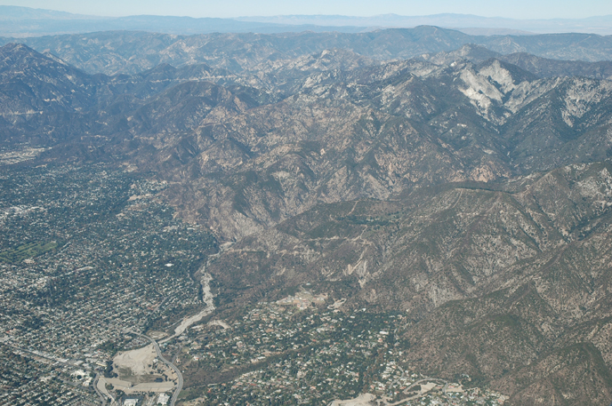


Altadena, California
Altadena is a community of 41,705 people in Los Angeles County, California, founded in 1887.
Why visit Altadena
Townapedia lists 86 museums and landmarks, 44 parks and trails, 59 places to eat, 1 place to stay and 17 attractions in and around town.
Highlights include Pasadena Playhouse, William Carey International University, Twenty-Five-Foot Space Simulator and Batchelder House.
August is the warmest month, with average highs of 91°F; December lows average 45°F.
Weather in Altadena
Forecast from the National Weather Service. Full forecast
About Altadena
Altadena (AL-tə-DEE-nə) is an unincorporated area and census-designated place in the San Gabriel Valley and the Verdugos regions of Los Angeles County, California. Directly north of Pasadena, it is located approximately 14 miles (23 km) from Downtown Los Angeles. Its population was 42,846 at the 2020 census, up slightly from a 2010 figure of 42,777. In early 2025, the community was severely impacted by the Eaton Fire.
From the Wikipedia article Altadena, California (this version), under CC BY-SA 4.0.
Things to do17

Pasadena Playhouse
Cinema and theater · National Register of Historic Places · 3.3 mi
Theater in Pasadena, California, United States

William Carey International University
School · 1.7 mi
Pasadena, California
1539 East Howard Street, Pasadena
California Institute of Technology
School · 3.8 mi
Private research university located in Pasadena, California, USA


5 more on the map.
Museums and landmarks86

Twenty-Five-Foot Space Simulator
Monument and historic site · National Register of Historic Places · 2.3 mi
Batchelder House
Monument and historic site · National Register of Historic Places · 4.3 mi
Listed on the National Register of Historic Places
Bekins Storage Co. Roof Sign
Monument and historic site · National Register of Historic Places · 3.9 mi
Neon sign in Pasadena, United States of America

Bryan Court
Monument and historic site · National Register of Historic Places · 3.8 mi
Building in California, United States
Bullock's Pasadena
Monument and historic site · National Register of Historic Places · 3.7 mi
Department store in California, United States of America
Christmas Tree Lane
Monument and historic site · National Register of Historic Places
Place in California listed on National Register of Historic Places
Colonial Court
Monument and historic site · National Register of Historic Places · 2.9 mi
Bungalow court in Pasadena, United States of America
Colorado Street Bridge
Monument and historic site · National Register of Historic Places · 3.7 mi
Bridge in Pasadena, California, United States of America
Cordelia A. Culbertson House
Monument and historic site · National Register of Historic Places · 4.5 mi
Historic house in California, United States


Cottage Court
Monument and historic site · National Register of Historic Places · 4.0 mi
Bungalow court located at 642–654 S. Marengo Ave. in Pasadena, California
Court at 1274-1282 North Raymond Avenue
Monument and historic site · National Register of Historic Places · 2.0 mi
Bungalow court in Pasadena, United States of America
Court at 275 North Chester Avenue
Monument and historic site · National Register of Historic Places · 3.0 mi
Bungalow court located at 275 North Chester Avenue in Pasadena, California
74 more on the map.
Parks, trails and playgrounds44



32 more on the map.
Restaurants and cafes59

Bacchus' Kitchen
Diner · American · 1.8 mi
1384 East Washington Boulevard, Pasadena
Mo,Su off; Tu-Sa 17:00-22:00

Blaze Pizza
Restaurant · Pizza · 2.6 mi
643 North Fair Oaks Ave, Pasadena
Mo-We,Su 10:30-23:00; Th 11:30-23:00; Fr-Sa 10:30-24:00

El Dorado Pollos A La Brasa
Restaurant · Peruvian · 2.5 mi
140 East Orange Grove Boulevard, Pasadena
Mo,We,Su 11:00-19:00; Tu off; Th-Sa 11:00-20:00
Fair Oaks Burger
Restaurant · Burger, Mexican, Chinese · 0.8 mi
2560 North Fair Oaks Avenue, Altadena
Mo-Sa 07:00-20:00
Perry's Joint
Restaurant · 1.6 mi
Eat Real Sandwiches
2051 Lincoln Avenue, Pasadena
Mo-Fr 11:00-16:00; Sa 11:00-15:00
47 more on the map.
Where to stay1
Churches and places of worship35
Pasadena Jewish Temple and Center
Place of worship · Jewish · 2.6 mi
1434 N. Altadena Drive, Pasadena
First Southern Baptist Church of Pasadena
Church · Baptist · 2.3 mi
2181 East Washington Boulevard
Shopping16
Gas and EV charging9
Schools, colleges and libraries69
Healthcare7
Map of Altadena
250 places. The map loads OpenStreetMap tiles when you open it.
Climate by month
Monthly table
| Month | High | Low | Rain | Snow |
|---|---|---|---|---|
| Jan | 68°F | 46°F | 4.5 in | 0.0 in |
| Feb | 69°F | 46°F | 5.2 in | 0.0 in |
| Mar | 73°F | 48°F | 3.0 in | 0.0 in |
| Apr | 76°F | 51°F | 1.1 in | 0.0 in |
| May | 78°F | 54°F | 0.5 in | 0.0 in |
| Jun | 84°F | 58°F | 0.2 in | 0.0 in |
| Jul | 89°F | 62°F | 0.1 in | 0.0 in |
| Aug | 91°F | 63°F | 0.0 in | 0.0 in |
| Sep | 90°F | 62°F | 0.2 in | 0.0 in |
| Oct | 83°F | 56°F | 0.8 in | 0.0 in |
| Nov | 75°F | 50°F | 1.1 in | 0.0 in |
| Dec | 67°F | 45°F | 3.3 in | 0.0 in |
U.S. Climate Normals 1991-2020 for Pasadena Hcn (3 mi away), NOAA NCEI.
People and cost of living
American Community Survey 5-year estimates, 2020-2024, U.S. Census Bureau. Estimates have margins of error, larger for small towns.
Disaster history
Los Angeles County has had 67 federal disaster declarations since 2000, most often for fires.
- 2025-08-08: Canyon Fire (Fire)
- 2025-01-08: Wildfires And Straight-Line Winds (Fire)
- 2025-01-08: Eaton Fire (Fire)
- 2025-01-08: Hurst Fire (Fire)
- 2025-01-07: Palisades Fire (Fire)
- 2024-12-10: Franklin Fire (Fire)
OpenFEMA disaster declarations summaries.
Getting there and nearby towns
San Gabriel Valley Airport (EMT) is the nearest airport with scheduled flights listed in OpenStreetMap, 9 miles away.
- Pasadena 2 mi south, about 4 min by car
- La Cañada Flintridge 4 mi west, about 6 min by car
- San Marino 5 mi south, about 8 min by car
- Sierra Madre 5 mi east, about 8 min by car
- Glendale 6 mi west, about 10 min by car
- South Pasadena 6 mi south, about 9 min by car
- East San Gabriel 6 mi southeast, about 10 min by car
- La Crescenta-Montrose 6 mi northwest, about 10 min by car
- Arcadia 7 mi southeast, about 11 min by car
- San Gabriel 7 mi south, about 11 min by car
Drive times are estimates from straight-line distance, not routes.
Local news
Headlines from INDB, the NEMICO news database.
Reviews, tips and questions
Loading what members have shared...
Sources and licences
- NCES EDGE (Public domain): public schools
- NOAA NCEI U.S. Climate Normals 1991-2020 (Public domain): climate by month
- OpenFEMA (Public domain): disaster declarations
- OpenStreetMap contributors (ODbL 1.0): places, airports, map data
- U.S. Census Bureau (Public domain): population, income, housing, education, commute
- Wikidata (CC0 1.0): elevation, founding date, time zone, website, landmarks and historic places
- Wikimedia Commons (see each image): photos
- Wikipedia (CC BY-SA 4.0): overview and history text
Photo credits
- Eaton canyon from the air, Bruce Perry, CC BY-SA 2.0
- Fenyes Estate 13, Rschen7754, CC BY-SA 3.0
- Court at 744 S. Marengo 6, TheCatalyst31, CC BY-SA 3.0
- House at 574 Bellefontaine Street, TheCatalyst31, CC BY-SA 3.0
- Court of Appeals, Coolcaesar, CC BY-SA 3.0
- BlackerHouse 7-1-07, John L. Poole, Public domain
- Cottage Court, Brianyoungramirez, CC BY-SA 3.0
- La Loma Bridge from side, TheCatalyst31, CC BY-SA 3.0
- House at 1050 South Madison Avenue 2, TheCatalyst31, CC BY-SA 3.0
- W.L. Mead House 3, Rschen7754, CC BY-SA 3.0
- Las Casitas Court, TheCatalyst31, CC0
- Gamble House 2016-1, Cullen328, CC BY-SA 3.0
- Deep-space-op, NASA/JPL-Caltech, Public domain
- 406 North Raymond Avenue, Pasadena, CA, TheCatalyst31, CC BY-SA 3.0
- William D. Davies Memorial Building, Gen. Charles S. Farnsworth County Park, TheCatalyst31, CC0
- Crank House 01, Einbierbitte, CC BY-SA 4.0
- Rose Court 2, TheCatalyst31, CC BY-SA 3.0
- Sara-Thel Court 2, Brianyoungramirez, CC BY-SA 3.0
- Old Town Pasadena and Metro Local bus, Adbar, CC BY-SA 3.0
- Bryan Court 2, TheCatalyst31, CC BY-SA 3.0
- First Mount Lowe Railway car to leave Altadena for Rubio Canyon, July 4, 1893 (CHS-40191), Unknown author Unknown author, Public domain
- WTBoltonHouse, Ellie Trevarthen, CC BY-SA 3.0
- Keyes Bungalow 1, Einbierbitte, CC0
- Palmetto Court 2, TheCatalyst31, CC BY-SA 3.0
- 2025 California Fires raw-153691 0128251904112 002 RGB2, NOAA / NODD, Public domain
- 2025 California Fires raw-153691 0128251904112 002 RGB1, NOAA / NODD, Public domain
- EATON FIRE NIR 20250112T183731, Copernicus Programme, Attribution
- Andrew McNally House after Eaton Fire 2025, Los Angeles County, Public domain
- Mapillary (uwrapid) 2025-09-24 16H06M53S000 (1570732240961332 at h1xCroWFqZYsaTy6bG2DiV with none), uwrapid, CC BY-SA 4.0
- Mapillary (uwrapid) 2025-09-24 16H06M53S000 (1519979105866330 at h1xCroWFqZYsaTy6bG2DiV with none), uwrapid, CC BY-SA 4.0
- Mapillary (uwrapid) 2025-09-24 16H06M52S000 (777720555080865 at h1xCroWFqZYsaTy6bG2DiV with none), uwrapid, CC BY-SA 4.0
- Mapillary (uwrapid) 2025-09-24 16H06M53S000 (3715945988710710 at h1xCroWFqZYsaTy6bG2DiV with none), uwrapid, CC BY-SA 4.0
- Mapillary (uwrapid) 2025-09-24 16H06M53S000 (4197981007147002 at h1xCroWFqZYsaTy6bG2DiV with none), uwrapid, CC BY-SA 4.0
- Mapillary (uwrapid) 2025-09-24 16H06M53S000 (2533254947092713 at h1xCroWFqZYsaTy6bG2DiV with none), uwrapid, CC BY-SA 4.0
- Mapillary (uwrapid) 2025-09-24 16H06M52S000 (753132487740642 at h1xCroWFqZYsaTy6bG2DiV with none), uwrapid, CC BY-SA 4.0
- Mapillary (uwrapid) 2025-09-24 16H06M52S000 (810807038366013 at h1xCroWFqZYsaTy6bG2DiV with none), uwrapid, CC BY-SA 4.0
- Mapillary (uwrapid) 2025-09-24 16H06M53S000 (654489241068777 at h1xCroWFqZYsaTy6bG2DiV with none), uwrapid, CC BY-SA 4.0
- Mapillary (uwrapid) 2025-09-24 16H06M53S000 (2294859510979616 at h1xCroWFqZYsaTy6bG2DiV with none), uwrapid, CC BY-SA 4.0
- Mapillary (uwrapid) 2025-09-24 16H06M52S000 (717112220661665 at h1xCroWFqZYsaTy6bG2DiV with none), uwrapid, CC BY-SA 4.0
- Mapillary (uwrapid) 2025-09-24 16H06M53S000 (852772437412177 at h1xCroWFqZYsaTy6bG2DiV with none), uwrapid, CC BY-SA 4.0


Page built October 30, 2026. Spotted a mistake? Tell us or suggest a place.