


Why visit Anderson
Townapedia lists 45 museums and landmarks, 32 parks and trails, 51 places to eat, 12 places to stay and 2 attractions in and around town.
Highlights include Mounds State Park, Anderson Bank Building, Anderson Country Club and Grandview Golf Course.
July is the warmest month, with average highs of 84°F; January lows average 21°F, and about 21 inches of snow fall in a normal year.
Weather in Anderson
Forecast from the National Weather Service. Full forecast
About Anderson
Anderson is a city in and the county seat of Madison County, Indiana, United States. The population was 54,788 at the 2020 census. It is named after Chief William Anderson. The city is the headquarters of the Church of God and its Anderson University.
From the Wikipedia article Anderson, Indiana (this version), under CC BY-SA 4.0.
Things to do2


Museums and landmarks45

Mounds State Park
Monument and historic site · National Register of Historic Places · 3.7 mi
State park in Indiana, United States

Anderson Bank Building
Monument and historic site · National Register of Historic Places · 3.0 mi
Historic building in Indiana

Anderson Center for the Arts
Museum · National Register of Historic Places · 1.2 mi
Library
Anderson Downtown Historic District
Monument and historic site · National Register of Historic Places · 1.1 mi
Historic district in Indiana, USA

Anderson High School Wigwam
Monument and historic site · National Register of Historic Places · 0.9 mi
Sports arena in Indiana, U.S.

Camp Chesterfield
Monument and historic site · National Register of Historic Places · 5.2 mi
Historic Spiritualist community in Indiana, United States
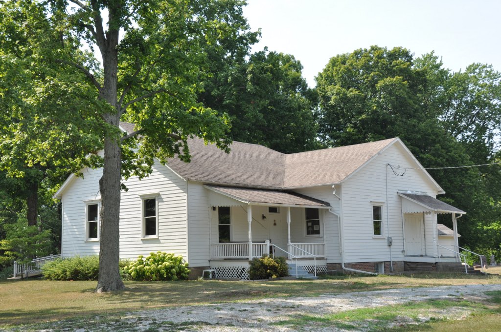
Fall Creek Meeting House
Monument and historic site · National Register of Historic Places · 6.7 mi
Historic meetinghouse in Indiana, United States

George Makepeace House
Monument and historic site · National Register of Historic Places · 5.2 mi
Historic house in Indiana, United States

Gruenewald House
Monument and historic site · National Register of Historic Places · 1.5 mi
Building in Indiana, United States

Madison County Bridge No. 149
Bridge · National Register of Historic Places · 6.2 mi
Road bridge in Indiana, United States of America


Paramount Theatre
Monument and historic site · National Register of Historic Places · 3.0 mi
Theater in Anderson, Indiana
Pendleton Historic District
Monument and historic site · National Register of Historic Places · 6.7 mi
Listed on the NRHP in Indiana
33 more on the map.
Parks, trails and playgrounds32



20 more on the map.
Restaurants and cafes51

Edgewood Pub & Dining
Diner · American · 3.3 mi
Welcome to Edgewood Pub & Dining, a beloved American restaurant business that has been nestled in Anderson, IN, since 1930. Our...
519 Golf Club Road, Anderson
Su-Mo closed, Tu-Sa 11:00-20:00

The Toast Cafe
Restaurant · Breakfast, American, Diner · 1.1 mi
Old-fashioned diner cooking up all-day breakfasts & American comfort classics for 60+ years.
28 East 13th Street, Anderson
Mo-Su 07:00-15:00
Edgewood Dining, Events, & Golf
Restaurant · 3.1 mi
Welcome to Edgewood Dining, Events, & Golf, a beloved American restaurant business that has been nestled in Anderson, IN, since 1930.
519 Golf Club Road, Anderson
Tu-Sa 11:00-20:00
Juan’s Mexican Grill & Bar
Restaurant · Mexican · 4.9 mi
127 Federal Drive, Chesterfield
Su 11:00-21:00, Mo-Th 11:00-22:00, Fr-Sa 11:00-22:30


Frazier's Dairy Maid
Ice cream · 0.8 mi
3311 Main Street, Anderson
Mo-Sa 11:00-21:00, Su 12:00-21:00
Gene's Root Beer Stand
Restaurant · Hot Dog · 2.4 mi
640 S. Scatterfield Road, Anderson
39 more on the map.
History
Prior to the organization of Madison County, William Conner entered the land upon which Anderson is located. Conner later sold the ground to John and Sarah Berry, who donated 32 acres (13 ha) of their land to Madison County on the condition that the county seat be moved from Pendleton to Anderson. John Berry laid out the first plat of Anderson on November 7, 1827. In 1828 the seat of justice was moved from Pendleton to Anderson.
The city is named for Chief William "Adam" Anderson, whose mother was Lenape and whose father was of Swedish descent. Chief Anderson's name in Lenape was Kikthawenund, meaning "creaking boughs". The Lenape village was known as "Anderson's Town", though the Moravian missionaries called it "The Heathen Town Four Miles Away". Anderson was also known as "Andersonton" before being formally organized as Anderson.
From the History section of Anderson, Indiana on Wikipedia, under CC BY-SA 4.0.
Where to stay12
Quality Inn & Suites Anderson I-69
Motel and hotel · 3.2 mi
1836 East 64th Street
Churches and places of worship30
East 38th Street Free Will Baptist Church
Church · Baptist · 1.6 mi
1125 East 38th Street, Anderson
Meadowbrook Church of Christ
Church · Church Of Christ · 1.0 mi
601 West 38th Street, Anderson
New Life Church - The Nazarene
Church · Nazarene · 1.4 mi
3615 Raible Avenue, Anderson
Shopping11
Gas and EV charging12
Schools, colleges and libraries36
Healthcare8
Map of Anderson
239 places. The map loads OpenStreetMap tiles when you open it.
Climate by month
Monthly table
| Month | High | Low | Rain | Snow |
|---|---|---|---|---|
| Jan | 35°F | 21°F | 3.0 in | 8.3 in |
| Feb | 39°F | 24°F | 2.5 in | 4.7 in |
| Mar | 50°F | 32°F | 3.5 in | 1.9 in |
| Apr | 63°F | 42°F | 4.1 in | 0.1 in |
| May | 73°F | 53°F | 4.6 in | 0.0 in |
| Jun | 81°F | 62°F | 5.2 in | 0.0 in |
| Jul | 84°F | 65°F | 4.3 in | 0.0 in |
| Aug | 82°F | 63°F | 3.4 in | 0.0 in |
| Sep | 77°F | 56°F | 3.1 in | 0.0 in |
| Oct | 65°F | 45°F | 3.4 in | 0.1 in |
| Nov | 51°F | 35°F | 3.7 in | 0.7 in |
| Dec | 39°F | 26°F | 3.0 in | 5.0 in |
U.S. Climate Normals 1991-2020 for Anderson Sewage Plt Hcn (2 mi away), NOAA NCEI.
People and cost of living
American Community Survey 5-year estimates, 2020-2024, U.S. Census Bureau. Estimates have margins of error, larger for small towns.
Disaster history
Madison County has had 16 federal disaster declarations since 2000, most often for severe storms.
- 2026-08-25: Severe Storms, Straight-Line Winds, Tornadoes, And Flooding (Flood)
- 2026-08-15: Severe Storms, Straight-Line Winds, Tornadoes, And Flooding (Flood)
- 2026-01-24: Severe Winter Storm (Winter Storm)
- 2025-07-22: Severe Storms, Straight-Line Winds, Tornadoes, And Flooding (Flood)
- 2020-04-03: Covid-19 Pandemic (Biological)
- 2020-03-13: Covid-19 (Biological)
OpenFEMA disaster declarations summaries.
Getting there and nearby towns
Anderson Municipal-Darlington Field Airport (AID) is the nearest airport with scheduled flights listed in OpenStreetMap, 4 miles away.
- Edgewood 3 mi west, about 4 min by car
- Chesterfield 5 mi east, about 9 min by car
- Pendleton 7 mi southwest, about 11 min by car
- Daleville 7 mi east, about 12 min by car
- Middletown 8 mi east, about 13 min by car
- Lapel 9 mi southwest, about 14 min by car
- Fishers 17 mi southwest, about 28 min by car
- Carmel 26 mi west, about 41 min by car
- Indianapolis city (balance) 32 mi southwest, about 52 min by car
- Avon 44 mi southwest, about 1 h 15 min by car
Drive times are estimates from straight-line distance, not routes.
Local news
Headlines from INDB, the NEMICO news database.
Reviews, tips and questions
Loading what members have shared...
Sources and licences
- NCES EDGE (Public domain): public schools
- NOAA NCEI U.S. Climate Normals 1991-2020 (Public domain): climate by month
- OpenFEMA (Public domain): disaster declarations
- OpenStreetMap contributors (ODbL 1.0): places, airports, map data
- U.S. Census Bureau (Public domain): population, income, housing, education, commute
- Wikidata (CC0 1.0): elevation, founding date, time zone, website, landmarks and historic places
- Wikimedia Commons (see each image): photos
- Wikipedia (CC BY-SA 4.0): overview and history text
Photo credits
- Anderson-indiana-from-above, Unknown author, Public domain
- Anderson Center for the Arts, Nyttend, Public domain
- PendletonIN Downtown, User:Magicpiano, CC BY-SA 4.0
- Neil McCullough House in Anderson, Nyttend, Public domain
- Anderson, Indiana - Paramount Theater, Publichall, CC BY-SA 3.0
- Anderson High School Wigwam, ONUnicorn, CC BY-SA 4.0
- FallCreekTwpIN FallCreekMeetingHouse, User:Magicpiano, CC BY-SA 4.0
- ChesterfieldIN ChesterfieldSpiritualistCampHousing, User:Magicpiano, CC BY-SA 4.0
- PendletonIN MadisonCountyBridge149, User:Magicpiano, CC BY-SA 4.0
- Anderson, IN - Anderson Bank Building, Publichall, CC BY-SA 3.0
- Tower Hotel (Tower Place), Anderson, Indiana, Nov 4th, 2011, Nealsoad, CC BY-SA 3.0
- George Makepeace House, Nyttend, Public domain
- Gruenewald House southern side, Nyttend, Public domain
- Tenth Street in the Anderson West Central HD, Nyttend, Public domain
- Anderson University Campus, Emmmmh, CC BY-SA 4.0
- Central Avenue School in Anderson, Nyttend, Public domain


Page built October 30, 2026. Spotted a mistake? Tell us or suggest a place.