


Astoria, Oregon
Astoria is a city of 10,109 people in Clatsop County, Oregon, founded in 1811.
Why visit Astoria
Townapedia lists 70 museums and landmarks, 22 parks and trails, 101 places to eat, 18 places to stay and 9 attractions in and around town.
Highlights include Liberty Theatre, Astoria Gateway Cinema, Columbia River Maritime Museum and Flavel House.
August is the warmest month, with average highs of 69°F; February lows average 37°F.
Weather in Astoria
Forecast from the National Weather Service. Full forecast
About Astoria
Astoria is a port city in and the county seat of Clatsop County, Oregon, United States. The population was 10,181 at the 2020 census. Founded in 1811, Astoria is the oldest city in the state and was the first permanent American settlement west of the Rocky Mountains. It is located on the south shore of the Columbia River in the northwest corner of Oregon, near where the river flows into the Pacific Ocean.
From the Wikipedia article Astoria, Oregon (this version), under CC BY-SA 4.0.
Things to do9

Liberty Theatre
Cinema and theater · National Register of Historic Places · 0.7 mi
Theater in Astoria, Oregon, USA


Astoria–Megler Bridge
Bridge · 1.8 mi
Bridge connecting Washington state and Oregon, USA
New Youngs Bay Bridge
Bridge · 2.7 mi
Vertical-lift roadbridge in Oregon, United States

Museums and landmarks70


Oregon Film Museum
Museum · 1.0 mi
Historic building
732 Duane Street, Astoria
May-Sep 10:00-17:00; Oct-Apr 10:00-16:00

Andrew Young House
Monument and historic site · National Register of Historic Places · 0.8 mi
Historic house in Astoria, Oregon, USA
3720 Duane Street, Astoria

Astoria Column
Monument and historic site · National Register of Historic Places · 0.4 mi
Tower in Astoria, Oregon, United States
1 Coxcomb Drive, Astoria

Astoria Victory Monument
Monument and historic site · National Register of Historic Places · 1.6 mi
Monument located in Astoria, Oregon, in the United States

Charles Stevens House
Monument and historic site · National Register of Historic Places · 0.7 mi
Building in Oregon, United States
1388 Franklin Avenue, Astoria

Clatsop County Courthouse
Monument and historic site · National Register of Historic Places · 1.0 mi
Courthouse in Astoria, Oregon, USA
749 Commercial Street, Astoria
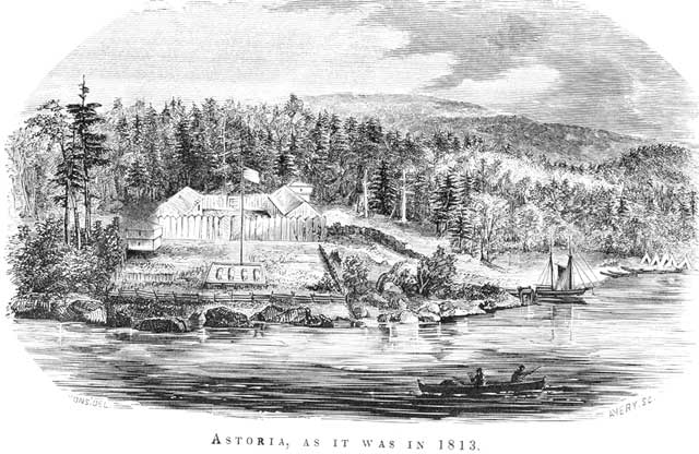
Fort Astoria
Monument and historic site · National Register of Historic Places · 0.6 mi
Former fortified trading post in Oregon, USA

Grace Episcopal Church
Monument and historic site · National Register of Historic Places · 0.5 mi
Church in Astoria, Oregon, USA


Gustavus Holmes House
Monument and historic site · National Register of Historic Places · 0.5 mi
Historic house in Astoria, Oregon, USA
682 34th Street, Astoria
58 more on the map.
Parks, trails and playgrounds22


10 more on the map.
Restaurants and cafes101

Columbia River Coffee Roaster
Cafe · Coffee Shop · 1.6 mi
279 West Marine Drive, Astoria
Mo-Sa 09:00-14:00

El Jarocho Mexican Restaurant
Restaurant · Mexican · 0.7 mi
175 14th Street, Astoria
Mo-Th 11:00-21:00, Fr-Sa 11:00-22:00, Su 12:00-21:00
Hurricane Ron's
Restaurant · Burger, American, Seafood, Fish And Chips, Crab, Bar, Beer · 0.7 mi
1335 Marine Drive, Astoria
Mo-Sa 11:00-18:00
Pig n' Pancake
Restaurant · Breakfast, Pancake, Lunch, Dinner, Coffee · 1.5 mi
146 West Bond Street, Astoria
Mo-Su 06:00-21:00
Rusty Cup
Cafe · Coffee Shop, Sandwich · 0.7 mi
1213 Commercial Street, Astoria
Mo-Fr 07:00-16:00; Sa-Su 08:00-16:00
Tokyo Teriyaki
Restaurant · Japanese, Sushi, Teriyaki, Miso, Ramen, Yakisoba, Sashimi, Chirashi · 0.6 mi
1446 Commercial Street, Astoria
Mo-Su 11:00-20:00
Busu Eatery Astoria
Restaurant · Japanese · 0.8 mi
275 11th Street
Tu-Th 12:00-17:00; Fr-Sa 12:00-20:00
Coffee Girl
Cafe · Coffee Shop · 1.1 mi
100 39th Street, Astoria
Mo-Th 07:00-16:00, Fr 07:00-17:00, Sa 08:00-17:00, Su 08:00-16:00
Dutch Bros. Coffee
Cafe · Coffee Shop · 2.1 mi
468 West Marine Drive, Astoria
Mo-Th 05:00-22:00; Fr-Sa 05:00-23:00; Su 05:00-22:00
Frite & Scoop
Restaurant · Dessert · 0.7 mi
175 14th Street, Astoria
Mo-Th 12:00-18:00, Fr-Su 12:00-20:00
89 more on the map.
Where to stay18
Best Western Columbia River Waterfront Hotel Astoria
Motel and hotel · 0.6 mi
3420 Leif Erickson Drive, Astoria
Churches and places of worship16
Saint Mary, Star of the Sea Catholic Church
Church · Roman Catholic · 0.6 mi
1465 Grand Avenue, Astoria
Astoria Church of Christ
Church · Churches Of Christ · 0.7 mi
692 12th Street, Astoria
Astoria Christian Church
Church · Protestant · 0.8 mi
1151 Harrison Avenue, Astoria
First United Methodist Church
Church · Methodist · 0.8 mi
1076 Franklin Avenue, Astoria
The Church of Jesus Christ of Latter-day Saints
Church · Mormon · 1.2 mi
350 Niagara Avenue, Astoria
Shopping33
Gas and EV charging11
Schools, colleges and libraries12
Lewis & Clark Elementary School
School · 3.1 mi
92179 Lewis And Clark Rd, Astoria
Healthcare6
Columbia Memorial Hospital Health Wellness Pavilion
Clinic and pharmacy
2265 Exchange Street, Astoria
Map of Astoria
250 places. The map loads OpenStreetMap tiles when you open it.
Climate by month
Monthly table
| Month | High | Low | Rain |
|---|---|---|---|
| Jan | 49°F | 38°F | 10.6 in |
| Feb | 51°F | 37°F | 7.2 in |
| Mar | 53°F | 39°F | 7.9 in |
| Apr | 56°F | 42°F | 5.8 in |
| May | 60°F | 46°F | 3.4 in |
| Jun | 64°F | 51°F | 2.3 in |
| Jul | 67°F | 54°F | 0.8 in |
| Aug | 69°F | 54°F | 1.1 in |
| Sep | 68°F | 50°F | 2.7 in |
| Oct | 61°F | 45°F | 6.7 in |
| Nov | 54°F | 40°F | 11.1 in |
| Dec | 49°F | 38°F | 10.7 in |
U.S. Climate Normals 1991-2020 for Astoria Rgnl Ap Hcn 72791 (4 mi away), NOAA NCEI.
People and cost of living
American Community Survey 5-year estimates, 2020-2024, U.S. Census Bureau. Estimates have margins of error, larger for small towns.
Disaster history
Clatsop County has had 12 federal disaster declarations since 2000, most often for severe storms.
- 2026-04-07: Severe Storms, Straight-Line Winds, Flooding, Landslides, And Mudslides (Severe Storm)
- 2020-03-28: Covid-19 Pandemic (Biological)
- 2020-03-13: Covid-19 (Biological)
- 2016-02-17: Severe Winter Storms, Straight-Line Winds, Flooding, Landslides, And Mudslides (Severe Storm)
- 2011-02-17: Severe Winter Storm, Flooding, Mudslides, Landslides, And Debris Flows (Severe Storm)
- 2009-03-02: Severe Winter Storm, Record And Near Record Snow (Severe Storm)
OpenFEMA disaster declarations summaries.
Getting there and nearby towns
Astoria Regional Airport (AST) is the nearest airport with scheduled flights listed in OpenStreetMap, 4 miles away.
- River Point 3 mi south, about 5 min by car
- Warrenton 6 mi west, about 9 min by car
- Svensen 8 mi east, about 13 min by car
- Chinook 9 mi northwest, about 14 min by car
- Knappa 11 mi east, about 18 min by car
- Gearhart 12 mi southwest, about 19 min by car
- Rosburg 12 mi northeast, about 19 min by car
- Ilwaco 13 mi northwest, about 22 min by car
- Naselle 13 mi north, about 21 min by car
- Seaside 15 mi south, about 24 min by car
Drive times are estimates from straight-line distance, not routes.
Local news
Headlines from INDB, the NEMICO news database.
Reviews, tips and questions
Loading what members have shared...
Sources and licences
- NCES EDGE (Public domain): public schools
- NOAA NCEI U.S. Climate Normals 1991-2020 (Public domain): climate by month
- OpenFEMA (Public domain): disaster declarations
- OpenStreetMap contributors (ODbL 1.0): places, airports, map data
- U.S. Census Bureau (Public domain): population, income, housing, education, commute
- Wikidata (CC0 1.0): elevation, founding date, time zone, website, landmarks and historic places
- Wikimedia Commons (see each image): photos
- Wikipedia (CC BY-SA 4.0): overview and history text
Photo credits
- Astoria, OR from the Astoria Column, aselfcallednowhere, CC BY-SA 3.0
- Mill Pond Village, Astoria aerial - panoramio, Sam Beebe/Ecotrust, CC BY-SA 3.0
- Astoria's Mill Pond Village development - panoramio, Sam Beebe/Ecotrust, CC BY-SA 3.0
- Astoria Fire House No. 2 - Astoria, Oregon, Steve Morgan, CC BY-SA 3.0
- Ludwig Larsen apartments, part of Erickson-Larsen Ensemble (Astoria, Ore), 2012, Steve Morgan, CC BY-SA 4.0
- Cathedral tree trail, Astoria, Oregon, Bobjgalindo, CC BY-SA 4.0
- Astoria Gateway Cinema, Bobjgalindo, CC BY-SA 4.0
- Peter and Maria Larson House - Astoria, Oregon, Steve Morgan, CC BY-SA 3.0
- Svenson Blacksmith Shop - Astoria Oregon, Ian Poellet, CC BY-SA 3.0
- Astoria Bridge from Astoria Column, Hedwigg, CC BY-SA 3.0
- Inside the top of the Astoria Column, Hedwigg, CC BY-SA 3.0
- Astoria Column, 2006, Hedwigg, CC BY-SA 3.0
- Astoria, Oregon city landscape, Ian Sane, CC BY 2.0
- Astoria - Megler Bridge (33339607832), Jeff Hitchcock from Seattle, WA, USA, CC BY 2.0
- Top half of Astoria Column, Jennifer Deal, CC BY-SA 4.0
- Astoria Column Cover from Parking Lot, Jennifer Deal, CC BY-SA 4.0
- Astoria Column, base, Bobjgalindo, CC BY-SA 4.0
- Astoria, OR - Astoria Column (6), Jrozwado, CC BY-SA 4.0
- Astoria, OR - Astoria Column (5), Jrozwado, CC BY-SA 4.0
- Astoria, OR - Astoria Column (8), Jrozwado, CC BY-SA 4.0
- Astoria, OR - Astoria Column (7), Jrozwado, CC BY-SA 4.0
- Astoria, OR - Astoria Column (2), Jrozwado, CC BY-SA 4.0
- Astoria, OR - Astoria Column (4), Jrozwado, CC BY-SA 4.0
- Astoria, OR - Astoria Column (1), Jrozwado, CC BY-SA 4.0
- Astoria, OR - Astoria Column (3), Jrozwado, CC BY-SA 4.0
- Astoria Column, angled, Bobjgalindo, CC BY-SA 4.0
- Astoria Riverfront Trolley car 300 at Maritime Museum, July 1999, Steve Morgan, CC BY-SA 3.0
- Old Clatsop County jail - Astoria Oregon, Ian Poellet, CC BY-SA 3.0
- Doughboy Monument - Astoria, Oregon, Steve Morgan, CC BY-SA 3.0
- Grace Episcopal Church and Rectory - Astoria, Oregon, Steve Morgan, CC BY-SA 3.0
- Young Andrew House - Astoria Oregon, Ian Poellet, CC BY-SA 3.0
- Clatsop County Courthouse - Astoria Oregon, Ian Poellet ( User:Werewombat ), CC BY-SA 3.0
- Franchere fort astoria 1813, Gabriel Franchère, Public domain
- Holmes House - Astoria Oregon, Ian Poellet, CC BY-SA 3.0
- Former Columbia Hospital on 16th St - Astoria, Oregon (2012) 2, Steve Morgan, CC BY-SA 3.0
- Charles Stevens House - Astoria, Oregon, Steve Morgan, CC BY-SA 3.0
- Ferdinand Fisher House - Astoria, Oregon, Steve Morgan, CC BY-SA 3.0
- Liberty Theatre 1 (Astoria, Oregon), Visitor7, CC BY-SA 3.0
- John N. Griffin House - Astoria, Oregon, Steve Morgan, CC BY-SA 3.0
- George C. and Winona Flavel House - Astoria, Oregon, Steve Morgan, CC BY-SA 3.0


Page built October 30, 2026. Spotted a mistake? Tell us or suggest a place.