


Auburn Hills, Michigan
Auburn Hills is a city of 25,105 people in Oakland County, Michigan, founded in 1983.
Why visit Auburn Hills
Townapedia lists 24 museums and landmarks, 52 parks and trails, 127 places to eat, 18 places to stay and 12 attractions in and around town.
Highlights include Flagstar Strand Theatre, Sea Life Aquarium, Casa del Rey Apartments and Central School.
July is the warmest month, with average highs of 82°F; January lows average 17°F, and about 36 inches of snow fall in a normal year.
Weather in Auburn Hills
Forecast from the National Weather Service. Full forecast
About Auburn Hills
Auburn Hills is a city in Oakland County in the U.S. state of Michigan. A northern suburb of Detroit, Auburn Hills is located about 26 miles (42 km) north of downtown Detroit. As of the 2020 census, the city had a population of 24,360.
From the Wikipedia article Auburn Hills, Michigan (this version), under CC BY-SA 4.0.
Things to do12


Sea Life Aquarium
Zoo and aquarium · 3.3 mi
4316 Baldwin Road, Auburn Hills
Mo-Fr 10:00-18:00; Sa 10:00-19:00; Su 11:00-18:00

Midwestern Baptist College
School · 4.2 mi
Small unaccredited, nonaffiliated school in Orion, Michigan
Oakland University
School · 1.4 mi
Public research university located in Michigan, USA
Rochester Christian University
School · 5.0 mi
Private Christian university in Rochester Hills, Michigan

Sea Life Michigan
Monument and historic site · 3.3 mi
Public aquarium in Auburn Hills, Michigan, USA

Meadow Brook Amphitheatre
Cinema and theater · 2.1 mi
234 Festival Drive, Rochester
Meadow Brook Theatre
Cinema and theater · 1.3 mi
378 Meadow Brook Road, Rochester
Museums and landmarks24

Casa del Rey Apartments
Monument and historic site · National Register of Historic Places · 4.5 mi
Multifamily residential in Pontiac, United States of America

Central School
Monument and historic site · National Register of Historic Places · 3.4 mi
School in Pontiac, Michigan, United States

Charles Torrey House
Monument and historic site · National Register of Historic Places · 4.2 mi
Single-family detached home in Bloomfield Township, United States of America
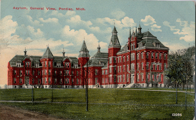
Clinton Valley Center
Monument and historic site · National Register of Historic Places · 4.5 mi
Psychiatric hospital located in Michigan

Eagle Theatre
Monument and historic site · National Register of Historic Places · 3.6 mi
Movie theater in Pontiac, Michigan, United States

Fairgrove Avenue Historic District
Monument and historic site · National Register of Historic Places · 3.3 mi
Historic residential district in Pontiac, Michigan, USA

Franklin Boulevard Historic District
Monument and historic site · National Register of Historic Places · 4.0 mi
Historic district in Pontiac, Michigan

Gillespie Street-Clinton River Bridge
Bridge · National Register of Historic Places · 4.3 mi
Road bridge in Pontiac, United States of America

Horatio N. Howard House
Monument and historic site · National Register of Historic Places · 3.2 mi
Pontiac, Michigan, listed on the NRHP in Oakland County

Meadow Brook Hall
Monument and historic site · National Register of Historic Places · 2.2 mi
Rochester Hills, Michigan, the former Estate of Matilda Dodge Wilson

Modern Housing Corporation Addition Historic District
Monument and historic site · National Register of Historic Places · 2.3 mi
Historic residential district in Pontiac, Michigan, USA


Myrick-Palmer House
Monument and historic site · National Register of Historic Places · 3.9 mi
House in Pontiac, United States of America
12 more on the map.
Parks, trails and playgrounds52


Innovation Hills Park
Park · 3.3 mi
2800 West Hamlin Road, Rochester Hills
Mo-Su 08:00-22:00
40 more on the map.
Restaurants and cafes127

Albert's Coney Grill Restaurant
Restaurant · Diner · 1.7 mi
2061 Featherstone Road, Auburn Hills
Mo-Fr 06:00-21:00; Sa,Su 07:00-15:00
Cantina El Dorado
Restaurant · Mexican · 3.0 mi
3300 Auburn Road, Auburn Hills
Mo-Su 00:00-02:00, 11:00-24:00
El Guanaco
Restaurant · Mexican, Salvadoran
2016 North Opdyke Road, Auburn Hills
Mo-Th 10:00-21:30; Fr-Sa 10:00-22:00; Su 10:00-21:00
Manhattan Fish & Chicken
Restaurant · Chicken, Fish · 0.9 mi
1101 East Walton Boulevard, Pontiac
Mo-Th,Su 11:00-23:00; Fr-Sa 11:00-24:00

Kerby's Koney Island
Restaurant · 2.4 mi
3224 East Walton Boulevard, Rochester Hills
Mo-Sa 10:00-20:00; Su 09:00-20:00
Kimchi Box
Restaurant · Korean · 0.6 mi
2713 University Drive
Tu-Fr 11:00-21:00; Mo, Sa 11:30-21:00; Su 12:00-21:30

Muldoon's
Bar and pub · 3.3 mi
3982 West Auburn Road, Rochester Hills
Mo-Sa 11:00-02:00, Su 12:00-02:00

Bob E's Super Chief
Diner · American · 3.6 mi
340 West Walton Boulevard, Pontiac
Mo-Sa 09:30-17:00
Dimitri's Opa Restaurant
Restaurant · American, Greek · 3.0 mi
3315 Auburn Road, Auburn Hills
Mo-Th 11:00-22:00; Fr 11:00-23:00; Sa 10:00-23:00
El Rincon Chilango
Restaurant · Mexican · 1.9 mi
1188 Joslyn Avenue
Tu-Su 10:00-21:00
115 more on the map.
History
In 1821, Auburn Hills began as Pontiac Township which included the village of Auburn at what is today the corner of Auburn and Squirrel roads. Situated on the Clinton River, it was named by Aaron Webster, the first settler, for Auburn, New York. His sawmill and grist mill attracted settlers to Auburn. After the streets were laid out in 1826, Auburn rivaled nearby Pontiac until the 1860s, when it lost its own prosperity. The town was renamed Amy in 1880, and it officially became Auburn Heights in 1919. Pontiac Township bordered the city of Pontiac on two sides.
In 1908, automobile pioneer John Dodge bought a farmhouse 3 miles (4.8 km) northeast of Auburn Heights to use as his country retreat. He and his wife, Matilda Dodge Wilson, continued to buy farmland, eventually totaling 1,400 acres. Dodge died in 1920, and Matilda Dodge later married lumber baron Alfred Gaston Wilson, with whom she built one of America's castles, Meadow Brook Hall, on a portion of the estate in present day Rochester Hills at a cost of $4 million ($58.2 million in 2025). In 1957, Matilda Dodge Wilson donated her land to Michigan State University, leading to the creation of Oakland University.
From the History section of Auburn Hills, Michigan on Wikipedia, under CC BY-SA 4.0.
Where to stay18
Holiday Inn Express & Suites Rochester Hills
Motel and hotel · 3.0 mi
3544 Marketplace Circle, Rochester Hills
WoodSpring Suites
Motel and hotel · 2.9 mi
3576 Marketplace Circle, Rochester Hills
Churches and places of worship46
St. Vincent DePaul Catholic Church, Convent, and School
Church · National Register of Historic Places · 3.7 mi
Bray Temple CME Church
Church · Methodist · 3.0 mi
46 North Roselawn Street, Pontiac
Christian Missionary Baptist
Church · Baptist · 3.1 mi
238 Mechanic Street, Pontiac
Columbia Avenue Baptist Church
Church · Baptist · 3.0 mi
64 West Columbia Avenue, Pontiac
Eastside Church of Christ
Church · Church Of Christ · 2.6 mi
149 Martin Luther King Jr Boulevard North, Pontiac
First Presbyterian Church Pontiac
Church · Presbyterian · 3.6 mi
99 Wayne Street, Pontiac
Friendship Missionary Baptist Church
Church · Baptist · 2.5 mi
599 Michigan Avenue, Pontiac
Heritage Baptist Church
Church · Baptist · 0.4 mi
2024 Pontiac Road, Auburn Hills
Shopping29
Gas and EV charging36
Schools, colleges and libraries81
Healthcare7
Map of Auburn Hills
250 places. The map loads OpenStreetMap tiles when you open it.
Climate by month
Monthly table
| Month | High | Low | Rain | Snow |
|---|---|---|---|---|
| Jan | 31°F | 17°F | 2.2 in | 12.1 in |
| Feb | 34°F | 18°F | 1.9 in | 9.0 in |
| Mar | 44°F | 26°F | 2.2 in | 4.1 in |
| Apr | 58°F | 36°F | 2.9 in | 0.9 in |
| May | 69°F | 49°F | 3.8 in | 0.0 in |
| Jun | 78°F | 59°F | 3.3 in | 0.0 in |
| Jul | 82°F | 63°F | 3.1 in | 0.0 in |
| Aug | 81°F | 62°F | 3.2 in | 0.0 in |
| Sep | 74°F | 54°F | 2.9 in | 0.0 in |
| Oct | 60°F | 42°F | 2.9 in | 0.1 in |
| Nov | 47°F | 32°F | 3.1 in | 1.7 in |
| Dec | 36°F | 24°F | 2.2 in | 8.1 in |
U.S. Climate Normals 1991-2020 for Pontiac Wwtp (3 mi away), NOAA NCEI.
People and cost of living
American Community Survey 5-year estimates, 2020-2024, U.S. Census Bureau. Estimates have margins of error, larger for small towns.
Disaster history
Oakland County has had 10 federal disaster declarations since 2000, most often for severe storms.
- 2024-02-08: Severe Storms, Tornadoes, And Flooding (Flood)
- 2021-07-15: Severe Storms, Flooding, And Tornadoes (Severe Storm)
- 2020-03-27: Covid-19 Pandemic (Biological)
- 2020-03-13: Covid-19 (Biological)
- 2014-09-25: Severe Storms And Flooding (Flood)
- 2005-09-07: Hurricane Katrina Evacuation (Hurricane)
OpenFEMA disaster declarations summaries.
Getting there and nearby towns
Oakland County International Airport (PTK) is the nearest airport with scheduled flights listed in OpenStreetMap, 9 miles away.
- Pontiac 3 mi southwest, about 5 min by car
- Rochester Hills 4 mi east, about 7 min by car
- Rochester 6 mi east, about 10 min by car
- Bloomfield Hills 6 mi south, about 10 min by car
- Sterling Heights 13 mi southeast, about 20 min by car
- Warren 17 mi southeast, about 27 min by car
- Detroit 21 mi south, about 34 min by car
- Dearborn 25 mi south, about 40 min by car
- Allen Park 29 mi south, about 46 min by car
- Ann Arbor 37 mi southwest, about 1 h by car
Drive times are estimates from straight-line distance, not routes.
Local news
Headlines from INDB, the NEMICO news database.
Reviews, tips and questions
Loading what members have shared...
Sources and licences
- NCES EDGE (Public domain): public schools
- NOAA NCEI U.S. Climate Normals 1991-2020 (Public domain): climate by month
- OpenFEMA (Public domain): disaster declarations
- OpenStreetMap contributors (ODbL 1.0): places, airports, map data
- U.S. Census Bureau (Public domain): population, income, housing, education, commute
- Wikidata (CC0 1.0): elevation, founding date, time zone, website, landmarks and historic places
- Wikimedia Commons (see each image): photos
- Wikipedia (CC BY-SA 4.0): overview and history text
Photo credits
- Approaching Interstate 75, Auburn Hills, Michigan (21096955914), Ken Lund from Reno, Nevada, USA, CC BY-SA 2.0
- Approaching Interstate 75, Auburn Hills, Michigan (21708142082), Ken Lund from Reno, Nevada, USA, CC BY-SA 2.0
- Fiat Chrysler Automobiles, Auburn Hills, Michigan (31658247531), Greg Gjerdingen from Willmar, USA, CC BY 2.0
- Shania Twain Rock This Country Tour Auburn Hills 2015, Cherologist, CC BY-SA 4.0
- Palace of Auburn Hills, Home of the Detroit Pistons, Auburn Hills, Michigan (21531752370), Ken Lund from Reno, Nevada, USA, CC BY-SA 2.0
- Palace of Auburn Hills, Home of the Detroit Pistons, Auburn Hills, Michigan (21531839018), Ken Lund from Reno, Nevada, USA, CC BY-SA 2.0
- Palace of Auburn Hills, Auburn Hills, Michigan, Ken Lund from Reno, Nevada, USA, CC BY-SA 2.0
- Palace of Auburn Hills, Home of the Detroit Pistons, Auburn Hills, Michigan (21693609806), Ken Lund from Reno, Nevada, USA, CC BY-SA 2.0
- Fairgrove Avenue Historic District Pontiac MI A, Andrew Jameson, CC BY-SA 3.0
- Charles Torrey House Birmingham MI, Andrew Jameson, CC BY-SA 3.0
- St Vincent DePaul Catholic Church Pontiac MI, Andrew Jameson, CC BY-SA 3.0
- Casa del Rey Apartments Pontiac MI, Andrew Jameson, CC BY-SA 3.0
- Wisner House Pontiac MI, Andrew Jameson, CC BY-SA 3.0
- Oak Hill Cemetery Pontiac MI A, Andrew Jameson, CC BY-SA 3.0
- Gillespie Street-Clinton River Bridge Pontiac MI, Andrew Jameson, CC BY-SA 3.0
- Horatio N Howard House Pontiac MI, Andrew Jameson, CC BY-SA 3.0
- Central School Pontiac MI, Andrew Jameson, CC BY-SA 3.0
- Meadowbrook Hall, Wm. Chris Rowland, II, CC BY-SA 3.0
- Pontiac Asylum c 1912, Unknown author Unknown author, Public domain
- Eagle Theater Pontiac MI, Andrew Jameson, CC BY-SA 3.0
- Franklin Boulevard Historic District Pontiac MI C, Andrew Jameson, CC BY-SA 3.0
- Myrick-Palmer House Pontiac MI, Andrew Jameson, CC BY-SA 3.0
- Pontiac Commercial Historic District A, Andrew Jameson, CC BY-SA 3.0
- Modern Housing Corporation Addition Historic District Pontiac MI A, Andrew Jameson, CC BY-SA 3.0
- RGIS - panoramio, donzigw, CC BY 3.0
- HHBOU, LaMoille123, CC BY-SA 4.0
- 1999, Chrysler Tech Center - 2014, Fiat Chrysler Automobiles (FCA) - panoramio, qwesy qwesy, CC BY 3.0
- 2006, Chrysler Tech Center - 2014, Fiat Chrysler Automobiles (FCA) - panoramio, qwesy qwesy, CC BY 3.0
- IGVC AutoNav 2023 Robot, Nczem, CC BY-SA 4.0
- Walter P. Chrysler Museum DSC00170 (30968089213), Greg Gjerdingen from Willmar, USA, CC BY 2.0
- ElliottTower1, LaMoille123, CC BY-SA 4.0
- Taken from the top of SEB looking towards Kresge Library at Oakland University in Rochester, MI, Brian Gingrich, Public domain
- Walter P. Chrysler Museum DSC00167 (30936322654), Greg Gjerdingen from Willmar, USA, CC BY 2.0
- ElliottTower2, LaMoille123, CC BY-SA 4.0
- ChryslerHQ-lowres, United States Geological Survey (USGS), Public domain
- ChryslerHQ-highres-colored, derivative work: MBisanz talk ChryslerHQ-highres.jpg : USGS, Public domain
- ChryslerHQ-highres, United States Geological Survey (USGS), Public domain
- McCafferty Tropfy, X96lee15, CC BY-SA 4.0
- King Versus Prince, Dave Hogg from Royal Oak, MI, USA, CC BY 2.0
- Automotion Elves (77257676), Dave Hogg from Royal Oak, MI, USA, CC BY 2.0


Page built October 30, 2026. Spotted a mistake? Tell us or suggest a place.