
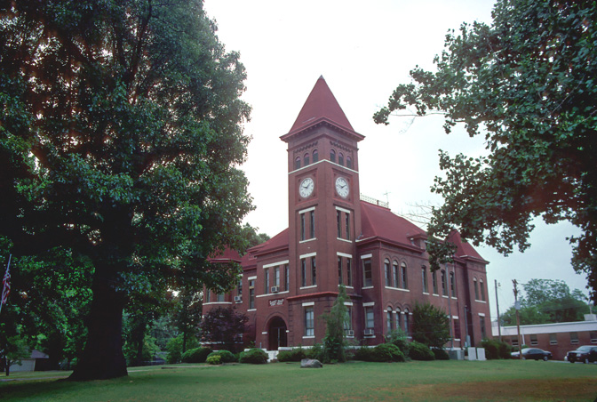


Augusta, Arkansas
Augusta is a city of 1,859 people in Woodruff County, Arkansas, founded in February 21, 1848.
Why visit Augusta
Townapedia lists 9 museums and landmarks and 2 parks and trails in and around town.
Highlights include Augusta Commercial Historic District and Augusta Memorial Park.
July is the warmest month, with average highs of 93°F; January lows average 30°F.
Weather in Augusta
Forecast from the National Weather Service. Full forecast
About Augusta
Augusta, officially the City of Augusta, is a city in Woodruff County, Arkansas, United States, located on the east bank of the White River. The population was 1,998 as of the 2020 Census. The city is the county seat of Woodruff County.
From the Wikipedia article Augusta, Arkansas (this version), under CC BY-SA 4.0.
Museums and landmarks9

Augusta Commercial Historic District
Monument and historic site · National Register of Historic Places · 0.4 mi
Historic district in Arkansas, United States

Augusta Memorial Park
Monument and historic site · National Register of Historic Places
Cemetery located in Augusta, Arkansas

Ferguson House
Monument and historic site · National Register of Historic Places
Historic house in Arkansas, United States

George Washington Carver High School Home Economics Building
Monument and historic site · National Register of Historic Places
Augusta, Arkansas, listed on the NRHP in Woodruff County, Arkansas

Gregory House
Monument and historic site · National Register of Historic Places · 0.5 mi
Historic house in Arkansas, United States
Jess Norman Post 166 American Legion Hut
Monument and historic site · National Register of Historic Places · 0.5 mi
Building in Arkansas, United States

Mathis-Hyde House
Monument and historic site · National Register of Historic Places
Augusta, Arkansas, listed on the NRHP in Woodruff County, Arkansas

Woodruff County Courthouse
Monument and historic site · National Register of Historic Places
County courthouse in Augusta, United States of America

Augusta Electrical Generating Plant
Monument and historic site · National Register of Historic Places
Parks, trails and playgrounds2

Churches and places of worship2


Augusta Presbyterian Church
Church · Presbyterian · National Register of Historic Places
Church building in Arkansas, United States of America
211 N 3rd St, Augusta

Schools, colleges and libraries3

History
In 1848, Thomas Hough had the village of Chickasaw Crossing, Arkansas, surveyed and laid out. The location was a natural riverboat landing spot on the navigable White River. In 1850, Hough renamed the settlement after his niece, Augusta Cald. Incorporated on July 9, 1860, in Jackson County, the town of Augusta became a part of Woodruff County when it was formed in the 1860s.
After the chaos of the American Civil War and its immediate aftermath, Augusta entered its greatest period of prosperity in the 1870s as a year-round riverboat transport point for a wide variety of goods, serving vessels from as far away as Memphis and New Orleans. Thus, when railroads began entering the county in the late 1800s, Augusta opted out of the apparently-unnecessary innovation and allowed their town to be bypassed by the tracks. When river traffic began to decline, the citizens realized their mistake, and decided to build their own railroad to link to the national rail grid. What became the Augusta Railroad lasted from 1886 to 1958 or 1959.
From the History section of Augusta, Arkansas on Wikipedia, under CC BY-SA 4.0.
Map of Augusta
16 places. The map loads OpenStreetMap tiles when you open it.
Climate by month
Monthly table
| Month | High | Low | Rain | Snow |
|---|---|---|---|---|
| Jan | 49°F | 30°F | 3.6 in | 0.7 in |
| Feb | 54°F | 33°F | 3.9 in | 0.6 in |
| Mar | 63°F | 42°F | 5.1 in | 0.4 in |
| Apr | 73°F | 50°F | 5.4 in | 0.0 in |
| May | 82°F | 61°F | 5.9 in | 0.0 in |
| Jun | 90°F | 69°F | 3.0 in | 0.0 in |
| Jul | 93°F | 73°F | 3.9 in | 0.0 in |
| Aug | 92°F | 71°F | 3.4 in | 0.0 in |
| Sep | 85°F | 63°F | 3.8 in | 0.0 in |
| Oct | 74°F | 51°F | 4.1 in | 0.0 in |
| Nov | 61°F | 40°F | 4.8 in | 0.0 in |
| Dec | 52°F | 33°F | 4.9 in | 0.1 in |
U.S. Climate Normals 1991-2020 for Searcy (20 mi away), NOAA NCEI.
People and cost of living
American Community Survey 5-year estimates, 2020-2024, U.S. Census Bureau. Estimates have margins of error, larger for small towns.
Disaster history
Woodruff County has had 21 federal disaster declarations since 2000, most often for severe storms.
- 2026-01-24: Severe Winter Storm (Winter Storm)
- 2025-05-21: Severe Storms, Tornadoes, And Flooding (Flood)
- 2025-04-05: Severe Storms, Tornadoes, And Flooding (Severe Storm)
- 2021-12-23: Severe Storms And Tornadoes (Tornado)
- 2020-08-27: Hurricane Laura (Hurricane)
- 2020-04-03: Covid-19 Pandemic (Biological)
OpenFEMA disaster declarations summaries.
Getting there and nearby towns
Searcy Municipal Airport (SRC) is the nearest airport with scheduled flights listed in OpenStreetMap, 22 miles away.
- Patterson 7 mi east, about 12 min by car
- McCrory 9 mi east, about 15 min by car
- Bald Knob 12 mi west, about 19 min by car
- Searcy 21 mi west, about 34 min by car
- Batesville 36 mi northwest, about 59 min by car
- Forrest City 37 mi southeast, about 1 h by car
- Austin 40 mi southwest, about 1 h by car
- Cabot 43 mi southwest, about 1 h 15 min by car
- Jacksonville 52 mi southwest, about 1 h 30 min by car
- Jonesboro 53 mi northeast, about 1 h 30 min by car
Drive times are estimates from straight-line distance, not routes.
Local news
Headlines from INDB, the NEMICO news database.
Reviews, tips and questions
Loading what members have shared...
Sources and licences
- NOAA NCEI U.S. Climate Normals 1991-2020 (Public domain): climate by month
- OpenFEMA (Public domain): disaster declarations
- OpenStreetMap contributors (ODbL 1.0): places, airports, map data
- U.S. Census Bureau (Public domain): population, income, housing, education, commute
- Wikidata (CC0 1.0): elevation, founding date, time zone, website, landmarks and historic places
- Wikimedia Commons (see each image): photos
- Wikipedia (CC BY-SA 4.0): overview and history text
Photo credits
- Woodruff County Arkansas Courthouse, Calvin Beale, Public domain
- Augusta, AR 028, Brandonrush, CC BY-SA 4.0
- Augusta, AR 036, Brandonrush, CC BY-SA 4.0
- Augusta, AR 005, Brandonrush, CC BY-SA 4.0
- Woodruff County Courthouse 004, Brandonrush, CC BY-SA 4.0
- Augusta, AR 010, Brandonrush, CC BY-SA 4.0
- Augusta, AR 020, Brandonrush, CC BY-SA 4.0
- Augusta, AR 027, Brandonrush, CC BY-SA 4.0
- Augusta, AR 022, Brandonrush, CC BY-SA 4.0
- Jess Norman Post 166 American Legion Hut, Valis55, CC BY-SA 3.0

Page built October 30, 2026. Spotted a mistake? Tell us or suggest a place.