
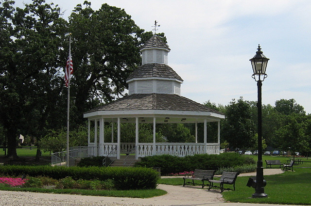


Bartlett, Illinois
Bartlett is a village of 40,501 people in Cook County, Illinois, founded in 1891.
Why visit Bartlett
Townapedia lists 8 museums and landmarks, 87 parks and trails, 87 places to eat, 6 places to stay and 1 attraction in and around town.
Highlights include Bloomingdale School, Oaklawn Farm, Ahlstrand Park and Jensen Park.
July is the warmest month, with average highs of 87°F; January lows average 14°F, and about 34 inches of snow fall in a normal year.
Weather in Bartlett
Forecast from the National Weather Service. Full forecast
About Bartlett
Bartlett is a village in Illinois, United States. The population was 41,105 at the 2020 census. The village is primarily located in Cook and DuPage counties, with a small parcel on the western border located in Kane County. Bartlett is part of the Chicago metropolitan area.
From the Wikipedia article Bartlett, Illinois (this version), under CC BY-SA 4.0.
Things to do1

Museums and landmarks8

Bloomingdale School
Monument and historic site · National Register of Historic Places · 4.9 mi
Bloomingdale, Illinois

Oaklawn Farm
Monument and historic site · National Register of Historic Places · 4.8 mi
Historic property in Wayne, Illinois, United States

Wayne Village Historic District
Monument and historic site · National Register of Historic Places · 3.6 mi
Historic district in Illinois, United States

Randecker's Hardware Store
Monument and historic site · National Register of Historic Places · 5.0 mi


Parks, trails and playgrounds87




75 more on the map.
Restaurants and cafes87

Baskin-Robbins
Ice cream · Ice Cream · 3.5 mi
185 West North Avenue, West Chicago
Mo-Sa 04:00-21:00; Su 05:00-20:30

Beef Shack
Restaurant · Beef, Sandwich · 1.8 mi
1084 Army Trail Road, Bartlett
Su-Th 10:30-21:00; Fr-Sa 10:30-22:00
Baskin-Robbins
Ice cream · 1.9 mi
880 West Army Trail Road, Carol Stream
Mo 05:00-22:00; Tu-Sa 04:00-22:00; Su 05:00-22:00
75 more on the map.
History
In its earliest times, the Village of Bartlett, Illinois, served as a hunting and camping ground for the Cherokee, Miami, Potawatomi, and Ottawa Indians. Throughout the past, the Northwest Territory, Virginia, Indiana, Spain, France and England had staked their claim for Bartlett. However, the territory was owned by a man named Luther Bartlett. Luther and Sophia Bartlett had decided that a station stop would be beneficial for their town and townspeople. In 1873, Bartlett gave a monetary contribution and half of his 40-acre woodlot towards the construction for a train depot, which is why the town is named after Luther Bartlett. Bartlett later became one of the premiere pig towns, becoming their main export for years to come. A petition for incorporation was filed in Springfield on February 11, 1891. The village was incorporated on June 21, 1892. Bartlett experienced the majority of its population growth in the 1980s.
From the History section of Bartlett, Illinois on Wikipedia, under CC BY-SA 4.0.
Where to stay6
Courtyard by Marriott Chicago Bloomingdale
Motel and hotel · 3.5 mi
275 Knollwood Drive, Bloomingdale
WoodSpring Suites Carol Stream
Motel and hotel · 3.5 mi
1160 North Gary Avenue, Carol Stream
Churches and places of worship35
Heritage Presbyterian Church
Church · Presbyterian · 3.0 mi
965 Kuhn Road, Carol Stream
Shopping15
Gas and EV charging22
Schools, colleges and libraries66
Healthcare10
American Family Medical Center - Urgent Care
Clinic and pharmacy · 3.4 mi
1865 North Neltnor Boulevard, West Chicago
Map of Bartlett
250 places. The map loads OpenStreetMap tiles when you open it.
Climate by month
Monthly table
| Month | High | Low | Rain | Snow |
|---|---|---|---|---|
| Jan | 32°F | 14°F | 1.9 in | 11.9 in |
| Feb | 37°F | 16°F | 1.7 in | 6.0 in |
| Mar | 48°F | 25°F | 2.1 in | 4.8 in |
| Apr | 61°F | 35°F | 3.6 in | 0.7 in |
| May | 73°F | 46°F | 4.7 in | 0.0 in |
| Jun | 83°F | 57°F | 4.7 in | 0.0 in |
| Jul | 87°F | 61°F | 3.3 in | 0.0 in |
| Aug | 85°F | 60°F | 4.5 in | 0.0 in |
| Sep | 78°F | 51°F | 3.6 in | 0.0 in |
| Oct | 65°F | 40°F | 3.5 in | 0.1 in |
| Nov | 50°F | 29°F | 2.5 in | 1.8 in |
| Dec | 38°F | 19°F | 1.9 in | 8.7 in |
U.S. Climate Normals 1991-2020 for Streamwood (4 mi away), NOAA NCEI.
People and cost of living
American Community Survey 5-year estimates, 2020-2024, U.S. Census Bureau. Estimates have margins of error, larger for small towns.
Disaster history
Cook County has had 12 federal disaster declarations since 2000, most often for severe storms.
- 2024-09-20: Severe Storms, Tornadoes, Straight-Line Winds, And Floodng (Flood)
- 2023-11-20: Severe Storms And Flooding (Flood)
- 2023-08-15: Severe Storms And Flooding (Severe Storm)
- 2020-03-26: Covid-19 Pandemic (Biological)
- 2020-03-13: Covid-19 (Biological)
- 2013-05-10: Severe Storms, Straight-Line Winds, And Flooding (Flood)
OpenFEMA disaster declarations summaries.
Getting there and nearby towns
DuPage County Airport (DPA) is the nearest airport with scheduled flights listed in OpenStreetMap, 6 miles away.
- Elgin 9 mi northwest, about 15 min by car
- Addison 9 mi east, about 14 min by car
- Barrington 13 mi north, about 22 min by car
- Arlington Heights 14 mi northeast, about 22 min by car
- Naperville 15 mi south, about 24 min by car
- Aurora 15 mi southwest, about 24 min by car
- Algonquin 16 mi northwest, about 25 min by car
- Chicago 27 mi east, about 43 min by car
- Alsip 30 mi southeast, about 49 min by car
- Joliet 31 mi south, about 49 min by car
Drive times are estimates from straight-line distance, not routes.
Local news
Headlines from INDB, the NEMICO news database.
Reviews, tips and questions
Loading what members have shared...
Sources and licences
- NCES EDGE (Public domain): public schools
- NOAA NCEI U.S. Climate Normals 1991-2020 (Public domain): climate by month
- OpenFEMA (Public domain): disaster declarations
- OpenStreetMap contributors (ODbL 1.0): places, airports, map data
- U.S. Census Bureau (Public domain): population, income, housing, education, commute
- Wikidata (CC0 1.0): elevation, founding date, time zone, website, landmarks and historic places
- Wikimedia Commons (see each image): photos
- Wikipedia (CC BY-SA 4.0): overview and history text
Photo credits
- Bartlett Illinois Gazebo (Bartlett Park), Bartlett, CC0
- Bartlett Public library picture, Ironclad12, CC BY-SA 4.0
- Bloomingdale School–Village Hall, Teemu08 ( talk ), CC BY-SA 3.0
- DunhamCastle, Otherbeach ( talk )BJS, CC BY-SA 3.0
- Wayne2011Snow, Otherbeach, CC BY 3.0
- Randecker's Hardware Store, Teemu08 ( talk ), CC BY-SA 3.0
- Schick Rd ^ Fairfax Ln - panoramio, Person1, CC BY 3.0
- Fairfax ^ Stockton - panoramio, Person1, CC BY 3.0
- Fairfax Lane - panoramio, Person1, CC BY 3.0
- Neighborhood Watch Community - panoramio, Person1, CC BY 3.0
- BHS main entrance, Annaliesemayer, CC BY-SA 4.0
- Cromwell Circle 3 - panoramio, Person1, CC BY 3.0
- Guest parking lot 3 - panoramio, Person1, CC BY 3.0
- West Branch Forest Preserve - panoramio, Person1, CC BY 3.0
- Mail box unit - panoramio, Person1, CC BY 3.0
- Guest parking lot - panoramio, Person1, CC BY 3.0
- Lawn on Cromwell cir - panoramio, Person1, CC BY 3.0
- View from up high - panoramio, Person1, CC BY 3.0
- Guest parking lol 2 - panoramio, Person1, CC BY 3.0
- Cromwell circle facing east - panoramio, Person1, CC BY 3.0
- Sidewalk south bound on Cromwell Circle - panoramio, Person1, CC BY 3.0
- Facing the long strip of grassy lawn - panoramio, Person1, CC BY 3.0
- Fairfax Lane facing north - panoramio, Person1, CC BY 3.0
- Empty artificial pond facing south - panoramio, Person1, CC BY 3.0
- Small backyard of the Fairfax Commons - panoramio, Person1, CC BY 3.0
- Path 2 - panoramio, Person1, CC BY 3.0
- Weird mobile home like structure - panoramio, Person1, CC BY 3.0
- Long field right off Cromwell circle - panoramio, Person1, CC BY 3.0
- Lake at forest preserve - panoramio, Person1, CC BY 3.0
- Stilt-legged fly 1, Bruce Marlin, CC BY-SA 3.0
- Empty artificial pond facing north - panoramio, Person1, CC BY 3.0
- Path 3 - panoramio, Person1, CC BY 3.0
- Forest preserve area - panoramio, Person1, CC BY 3.0
- Well - panoramio - Person1, Person1, CC BY 3.0
- Forest preserve - panoramio, Person1, CC BY 3.0
- Guest parking lot by E Fairfax - panoramio, Person1, CC BY 3.0
- Path 1 - panoramio, Person1, CC BY 3.0
- Path - panoramio - Person1, Person1, CC BY 3.0
- Bench near water - panoramio, Person1, CC BY 3.0
- View 2 of lake - panoramio, Person1, CC BY 3.0


Page built October 30, 2026. Spotted a mistake? Tell us or suggest a place.