



Beltsville, Maryland
Beltsville is a community of 19,176 people in Prince George's County, Maryland.
Why visit Beltsville
Townapedia lists 12 museums and landmarks, 35 parks and trails, 50 places to eat, 9 places to stay and 7 attractions in and around town.
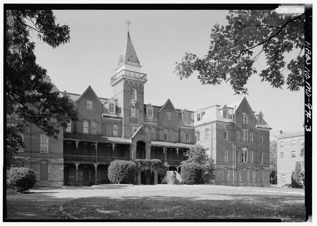
Highlights include Loews Center Park 8, Capitol Technology University, Ammendale Normal Institute and Abraham Hall.
July is the warmest month, with average highs of 87°F; January lows average 25°F.
Weather in Beltsville
Forecast from the National Weather Service. Full forecast
About Beltsville
Beltsville is a census-designated place (CDP) in northern Prince George's County, Maryland, United States. The community was named for Truman Belt, a local landowner. The 2020 census counted 20,133 residents. Beltsville includes the unincorporated community of Vansville.
From the Wikipedia article Beltsville, Maryland (this version), under CC BY-SA 4.0.
Things to do7


Capitol Technology University
School · 3.7 mi
University near Washington, DC, United States

Clarice Smith Performing Arts Center
Cinema and theater · 3.8 mi
Theater and concert hall of the University of Maryland in College Park, Maryland, United States
Greenbelt Arts Center
Cinema and theater · 3.5 mi
Performance art theatre in the Roosevelt Center in Greenbelt, Maryland, United States

University of Maryland
School · 3.8 mi
Public research university in the city of College Park in Prince George's County, Maryland, USA

University of Maryland Global Campus
School · 4.2 mi
One of 11 degree-granting institutions within the University System of Maryland
Museums and landmarks12
Ammendale Normal Institute
Monument and historic site · National Register of Historic Places · 1.3 mi
Historical Catholic novitiate and school, operated by the Christian Brothers in Beltsville, Maryland, United States

Abraham Hall
Museum · National Register of Historic Places · 2.9 mi
Historic African American benevolent society lodge in Prince George's County, Maryland, United States

College Park Airport
Monument and historic site · National Register of Historic Places · 4.1 mi
Airport in College Park, Maryland, United States

Greenbelt Historic District
Monument and historic site · National Register of Historic Places · 3.6 mi
National Historic Landmark District in Prince George’s County, Maryland, United States

Marenka House
Monument and historic site · National Register of Historic Places · 4.4 mi
Historic house at 7300 Radcliffe Drive in College Park, Maryland
Montpelier Mansion
Monument and historic site · National Register of Historic Places · 4.4 mi
Human settlement in Maryland, United States of America
National Archives archeological site
Monument and historic site · National Register of Historic Places · 3.5 mi
Archeological site at the United States National Archives' property in College Park, Maryland, United States

O'Dea House
Monument and historic site · National Register of Historic Places · 3.1 mi
Historic house in Maryland, United States

Rachel Carson House
Monument and historic site · National Register of Historic Places · 4.3 mi
Where Rachel Carson wrote Silent Spring, listed on the U.S. National Register of Historic Places

National Museum of Language
Museum · 4.5 mi
Online museum in Greenbelt, Maryland

University of Maryland Art Gallery
Museum · 4.0 mi
Art museum in College Park, Maryland
Parks, trails and playgrounds35

Dinosaur Park
Park · 3.5 mi
Park in Maryland, United States of America

Greenbelt Park
Park · 4.1 mi
Park in Greenbelt, Maryland, managed by the United States National Park Service


McKeldin Mall
Park · 3.9 mi
Green space at the University of Maryland, College Park campus



23 more on the map.
Restaurants and cafes50



Sardi's Pollo A La Brasa
Restaurant · Peruvian, Chicken · 0.9 mi
10433 Baltimore Avenue
Mo-Sa 10:30-22:00; Su 11:00-21:30
Gong Cha and Fuji Teriyaki
Restaurant · Asian, Bubble Tea · 2.1 mi
12058 Cherry Hill Road, Silver Spring
38 more on the map.
History
Beltsville's history dates back to 1649, when the land was part of an 80,000-acre (324 km2) land grant given to Richard Snowden I by Lord Baltimore of England. Snowden and his family were planters who established large plantations on which they built comfortable manor homes. Soon after, other settlers moved into the area, but they were farmers who could only afford a few acres of land and whose families lived in small cabins. The principal crop was tobacco, most of which was shipped to England. Because of the fertile soil and desirable growing conditions, the crops prospered.
Industry came to Beltsville in the early 18th century when iron ore was discovered in the area. The Muirkirk Iron Furnace on US 1 was established by Andrew and Elias Elliott, who learned their iron-making skills in Muirkirk, Scotland. They produced some of the best-quality pig iron in the country and supplied the U.S. Army with cannons, shot, wheels, and other iron products during the Revolutionary War and the Civil War.
By 1730, Post Road (now part of US 1) was the main thoroughfare through Beltsville. Though crude, it made stagecoach travel possible. In 1783, Gabriel Peterson Van Horn established a stage line and built the Van Horn Tavern on Odell Road, where passengers could spend the night as they traveled between Baltimore and Washington. The trip took one and one-half days.
From the History section of Beltsville, Maryland on Wikipedia, under CC BY-SA 4.0.
Where to stay9
Comfort Inn Capital-Beltway, Beltsville, MD
Motel and hotel · 1.1 mi
4050 Powder Mill Road, Beltsville
Holiday Inn Washington - College Pk (I-95)
Motel and hotel · 1.4 mi
10000 Baltimore Avenue, College Park
Churches and places of worship28
Abyssinia Baptist Church
Church · Baptist · 2.1 mi
3106 Fairland Road, Silver Spring
Beltsville Maranatha Spanish Seventh-day Adventist Church
Church · Seventh Day Adventist
11310 Montgomery Road, Beltsville
Beltsville Seventh-day Adventist Church
Church · Seventh Day Adventist · 0.9 mi
4200 Ammendale Road, Beltsville
College Park United Methodist Church
Church · United Methodist · 2.0 mi
9601 Rhode Island Avenue, College Park
Filipino American Capital Seventh-day Adventist Church
Church · Seventh Day Adventist · 0.8 mi
4216 Powder Mill Road, Beltsville
Shopping9
Gas and EV charging24
Schools, colleges and libraries58
Healthcare5
Map of Beltsville
237 places. The map loads OpenStreetMap tiles when you open it.
Climate by month
Monthly table
| Month | High | Low | Rain | Snow |
|---|---|---|---|---|
| Jan | 43°F | 25°F | 2.9 in | 5.7 in |
| Feb | 46°F | 27°F | 2.4 in | 5.0 in |
| Mar | 53°F | 34°F | 3.7 in | 2.5 in |
| Apr | 65°F | 44°F | 3.3 in | 0.1 in |
| May | 74°F | 54°F | 4.3 in | 0.0 in |
| Jun | 83°F | 63°F | 4.2 in | 0.0 in |
| Jul | 87°F | 68°F | 4.5 in | 0.0 in |
| Aug | 86°F | 66°F | 3.9 in | 0.0 in |
| Sep | 79°F | 59°F | 4.4 in | 0.0 in |
| Oct | 68°F | 47°F | 4.0 in | 0.0 in |
| Nov | 57°F | 37°F | 2.9 in | 0.2 in |
| Dec | 47°F | 30°F | 3.5 in | 2.3 in |
U.S. Climate Normals 1991-2020 for Beltsville Hcn (1 mi away), NOAA NCEI.
People and cost of living
American Community Survey 5-year estimates, 2020-2024, U.S. Census Bureau. Estimates have margins of error, larger for small towns.
Disaster history
Prince George's County has had 13 federal disaster declarations since 2000, most often for hurricanes.
- 2026-01-24: Severe Winter Storm (Winter Storm)
- 2020-03-26: Covid-19 Pandemic (Biological)
- 2020-03-13: Covid-19 (Biological)
- 2016-03-04: Severe Winter Storm And Snowstorm (Snowstorm)
- 2012-11-20: Hurricane Sandy (Hurricane)
- 2012-10-28: Hurricane Sandy (Hurricane)
OpenFEMA disaster declarations summaries.
Getting there and nearby towns
College Park Airport (CGS) is the nearest airport with scheduled flights listed in OpenStreetMap, 4 miles away.
- Adelphi 4 mi southwest, about 6 min by car
- Aspen Hill 9 mi northwest, about 15 min by car
- Washington 11 mi southwest, about 17 min by car
- Columbia 12 mi north, about 19 min by car
- Arlington 15 mi southwest, about 24 min by car
- Alexandria 18 mi southwest, about 28 min by car
- Arbutus 19 mi northeast, about 30 min by car
- Arnold 22 mi east, about 36 min by car
- Annapolis 23 mi east, about 37 min by car
- Baltimore 24 mi northeast, about 39 min by car
Drive times are estimates from straight-line distance, not routes.
Local news
Headlines from INDB, the NEMICO news database.
Reviews, tips and questions
Loading what members have shared...
Sources and licences
- NCES EDGE (Public domain): public schools
- NOAA NCEI U.S. Climate Normals 1991-2020 (Public domain): climate by month
- OpenFEMA (Public domain): disaster declarations
- OpenStreetMap contributors (ODbL 1.0): places, airports, map data
- U.S. Census Bureau (Public domain): population, income, housing, education, commute
- Wikidata (CC0 1.0): elevation, founding date, time zone, website, landmarks and historic places
- Wikimedia Commons (see each image): photos
- Wikipedia (CC BY-SA 4.0): overview and history text
Photo credits
- United States National Agricultural Library, USDA-ARS, Public domain
- Ammendale SE 1990, Jack Boucher, Public domain
- Montpellier Maryland 2, The original uploader was Quarterczar at English Wikipedia ., Public domain
- Abraham Hall Dec 08, Pubdog ( talk ), Public domain
- Greenbelt Community Center 2018, Carol M. Highsmith, Public domain
- ODea House Dec 08, Pubdog ( talk ), Public domain
- Rachel carson house md, Eli.pousson, CC BY-SA 3.0
- Marenka House, Farragutful, CC BY-SA 4.0
- 50th-Loh-Driskell-Henney, Billlayton, CC BY-SA 4.0
- UMD McKeldin sundial, Bgervais, CC BY-SA 3.0
- Dinosaur Park Laurel, Paul, CC BY-SA 2.0
- Clarice Smith Performing Arts Center, Bpaulh ( talk ), Public domain
- Mckeldin Mall, Radhika Kshirsagar, CC BY-SA 4.0
- Microstegium vimineum - Greenbelt MD, Michael Ellis, CC BY-SA 4.0
- St. John the Baptist SSMD 01, Farragutful, CC BY-SA 3.0
- UMUC3, M Chambers, CC BY 3.0

Page built October 30, 2026. Spotted a mistake? Tell us or suggest a place.