


Why visit Bemidji
Townapedia lists 15 museums and landmarks, 24 parks and trails, 76 places to eat, 11 places to stay and 3 attractions in and around town.
Highlights include Nymore Bridge, Northwest Technical College, Beltrami County Courthouse and David Park House.
July is the warmest month, with average highs of 79°F; January lows average -4°F, and about 49 inches of snow fall in a normal year.
Weather in Bemidji
Forecast from the National Weather Service. Full forecast
About Bemidji
Bemidji is a city in and the county seat of Beltrami County, Minnesota, United States. The population was 14,574 as of the 2020 census, and was estimated at 15,770 in 2025, making it the largest commercial center between Grand Forks, North Dakota and Duluth.
From the Wikipedia article Bemidji, Minnesota (this version), under CC BY-SA 4.0.
Things to do3
Nymore Bridge
Bridge · National Register of Historic Places · 1.4 mi
Bridge in United States of America

Northwest Technical College
School · 2.7 mi
Public technical college in Bemidji, Minnesota, United States

The Chief Theatre
Cinema and theater · 1.1 mi
Home of the Paul Bunyan Playhouse
314 Beltrami Avenue Northwest, Bemidji
Museums and landmarks15

Beltrami County Courthouse
Monument and historic site · National Register of Historic Places · 0.9 mi
County courthouse in Bemidji, United States of America
David Park House
Monument and historic site · National Register of Historic Places · 0.4 mi
Historic house in Bemidji, Minnesota
1501 Birchmont Drive Northeast, Bemidji

Bemidji Carnegie Library
Monument and historic site · National Register of Historic Places · 1.0 mi
Carnegie library and former public library
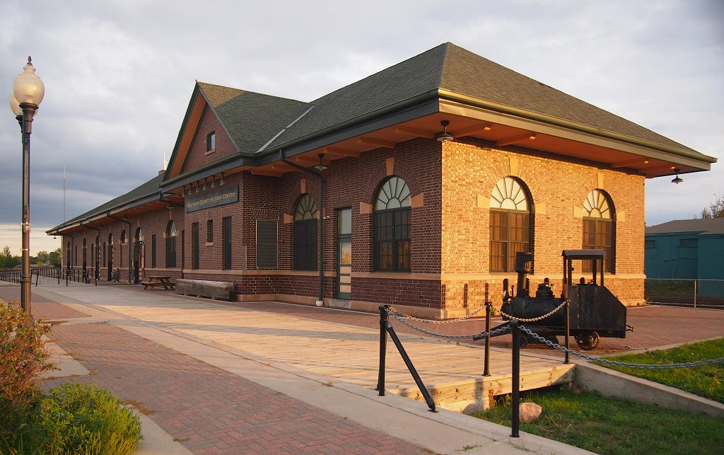
Great Northern Depot
Monument and historic site · National Register of Historic Places · 1.3 mi
Railway station in Bemidji, the United States of America


Paul Bunyan and Babe the Blue Ox
Monument and historic site · National Register of Historic Places · 1.0 mi
Pair of large statues in Minnesota

Headwaters Science Center
Museum · 1.0 mi
413 Beltrami Avenue Northwest, Bemidji
Mo-Sa 09:30-17:00; Su 13:00-17:00; PH off

Paul Bunyan and Babe the Blue Ox Statue
Monument and historic site · 1.2 mi
300 Bemidji Avenue North, Bemidji
Bangsberg Fine Arts Complex
Museum · 0.5 mi
1330 Birchmont Drive Northeast, Bemidji
The Old Schoolhouse
Monument and historic site · 3.4 mi
2335 Monroe Avenue Southwest, bemidji
3 more on the map.
Parks, trails and playgrounds24

Diamond Point Park
Park · 0.6 mi
1720 Birchmont Drive Northeast, Bemidji

Chet Anderson Stadium
Sports field and stadium · 0.5 mi
1514 Birchmont Drive Northeast, Bemidji



12 more on the map.
Restaurants and cafes76

Tutto Bene
Restaurant · Italian · 1.1 mi
300 Beltrami Avenue Northwest, Bemidji
11:00-14:00,16:00-21:00; Su-Mo closed



64 more on the map.
History
Beltrami County was established by an act of legislation on February 28, 1866.
Bemidji Township was surveyed by European Americans in 1874. It was organized in 1896, 24 days after the village of Bemidji was chartered, and is the oldest township in the county. In 1897, the county attorney declared the original Bemidji township organization illegal (no reason given) and the township reorganized on June 26, 1897.
About 50 Leech Lake Indians lived along the south shore of the lake prior to the 1880s. They called the lake Bemidjigumaug, meaning "river or route flowing crosswise". Freeman and Besty Doud claimed 160 acres west of and including present-day Diamond Point; they were Bemidji's first homesteaders. The Porter Nye family soon followed them.
From the History section of Bemidji, Minnesota on Wikipedia, under CC BY-SA 4.0.
Where to stay11
Lake Bemidji Bed & Breakfast
Motel and hotel · 0.7 mi
915 Lake Boulevard Northeast, Bemidji
Candlewood Suites
Motel and hotel · 2.2 mi
401 Paul Bunyan Drive Southeast, Bemidji
Churches and places of worship24
Kingdom Hall of Jehovah's Witnesses
Church · Jehovahs Witness · 2.1 mi
1659 Adams Avenue Northwest, Bemidji
Saint Philip's Catholic Church
Church · Roman Catholic · 0.9 mi
702 Beltrami Avenue Northwest, Bemidji
Calvary Lutheran Church
Church · Evangelical Lutheran · 3.6 mi
2508 Washington Avenue South, Bemidji
Bethany Free Lutheran Church
Church · 0.4 mi
1300 Beltrami Avenue Northwest, Bemidji
Shopping40
Gas and EV charging10
Schools, colleges and libraries30
Healthcare15
Sanford Health Walk-in and Pediatric Clinic
Clinic and pharmacy · 1.6 mi
1233 34th Street, Bemidji
Northwoods Pregnancy Center
Clinic and pharmacy
2300 Bemidji Avenue North, Bemidji
Map of Bemidji
248 places. The map loads OpenStreetMap tiles when you open it.
Climate by month
Monthly table
| Month | High | Low | Rain | Snow |
|---|---|---|---|---|
| Jan | 18°F | -4°F | 0.8 in | 9.1 in |
| Feb | 24°F | 0°F | 0.7 in | 9.3 in |
| Mar | 37°F | 14°F | 1.2 in | 6.2 in |
| Apr | 51°F | 29°F | 2.0 in | 5.6 in |
| May | 65°F | 42°F | 2.9 in | 0.0 in |
| Jun | 74°F | 53°F | 4.1 in | 0.0 in |
| Jul | 79°F | 58°F | 3.7 in | 0.0 in |
| Aug | 77°F | 56°F | 3.1 in | 0.0 in |
| Sep | 68°F | 47°F | 2.9 in | 0.0 in |
| Oct | 52°F | 34°F | 2.8 in | 1.4 in |
| Nov | 36°F | 20°F | 1.3 in | 5.8 in |
| Dec | 23°F | 6°F | 1.0 in | 11.5 in |
U.S. Climate Normals 1991-2020 for Cass Lake (14 mi away), NOAA NCEI.
People and cost of living
American Community Survey 5-year estimates, 2020-2024, U.S. Census Bureau. Estimates have margins of error, larger for small towns.
Disaster history
Beltrami County has had 10 federal disaster declarations since 2000, most often for floods.
- 2022-07-13: Severe Storms, Straight-Line Winds, And Flooding (Flood)
- 2020-04-07: Covid-19 Pandemic (Biological)
- 2020-03-13: Covid-19 (Biological)
- 2018-09-05: Severe Storms, Tornadoes, Straight-Line Winds, And Flooding (Flood)
- 2014-07-21: Severe Storms, Straight-Line Winds, Flooding, Landslides, And Mudslides (Flood)
- 2011-05-10: Severe Storms And Flooding (Flood)
OpenFEMA disaster declarations summaries.
Getting there and nearby towns
Bemidji Regional Airport (BJI) is the nearest airport with scheduled flights listed in OpenStreetMap, 3 miles away.
- Wilton 6 mi west, about 9 min by car
- Cass Lake 15 mi southeast, about 24 min by car
- Blackduck 23 mi northeast, about 37 min by car
- Bagley 24 mi west, about 39 min by car
- Redby 26 mi north, about 43 min by car
- Red Lake 27 mi north, about 44 min by car
- Little Rock 28 mi north, about 45 min by car
- Clearbrook 29 mi northwest, about 47 min by car
- Walker 31 mi southeast, about 49 min by car
- Park Rapids 40 mi south, about 1 h by car
Drive times are estimates from straight-line distance, not routes.
Local news
Headlines from INDB, the NEMICO news database.
Reviews, tips and questions
Loading what members have shared...
Sources and licences
- NCES EDGE (Public domain): public schools
- NOAA NCEI U.S. Climate Normals 1991-2020 (Public domain): climate by month
- OpenFEMA (Public domain): disaster declarations
- OpenStreetMap contributors (ODbL 1.0): places, airports, map data
- U.S. Census Bureau (Public domain): population, income, housing, education, commute
- Wikidata (CC0 1.0): elevation, founding date, time zone, website, landmarks and historic places
- Wikimedia Commons (see each image): photos
- Wikipedia (CC BY-SA 4.0): overview and history text
Photo credits
- Bemidji, Minnesota aerial, Doc Searls from Santa Barbara, USA, CC BY 2.0
- Deputy Hall-Bemidji State University-04, Myotus, CC BY 4.0
- David Park House, McGhiever, CC BY-SA 3.0
- Beltrami County Judicial Center and old Courthouse Bemidji, Minnesota, Myotus, CC BY 4.0
- Bemidji Carnegie Library, McGhiever, CC BY-SA 3.0
- Nymore Bridge, McGhiever, CC BY-SA 3.0
- Bemidji Great Northern Depot, McGhiever, CC BY-SA 3.0
- Paul Bunyan and Babe the Blue Ox, Kubber333, CC BY-SA 4.0
Page built October 30, 2026. Spotted a mistake? Tell us or suggest a place.