


Why visit Berlin
Townapedia lists 3 museums and landmarks, 1 park or trail, 2 places to eat and 4 places to stay in and around town.
Highlights include Boyd School and Amish & Mennonite Heritage Center.
July is the warmest month, with average highs of 84°F; January lows average 18°F, and about 20 inches of snow fall in a normal year.
Weather in Berlin
Forecast from the National Weather Service. Full forecast
About Berlin
Berlin is an unincorporated community and census-designated place in central Berlin Township, Holmes County, Ohio, United States. It had a population of 1,447 at the 2020 census. Located in Ohio's Amish Country, the village is part of a large regional tourism industry.
From the Wikipedia article Berlin, Holmes County, Ohio (this version), under CC BY-SA 4.0.
Museums and landmarks3
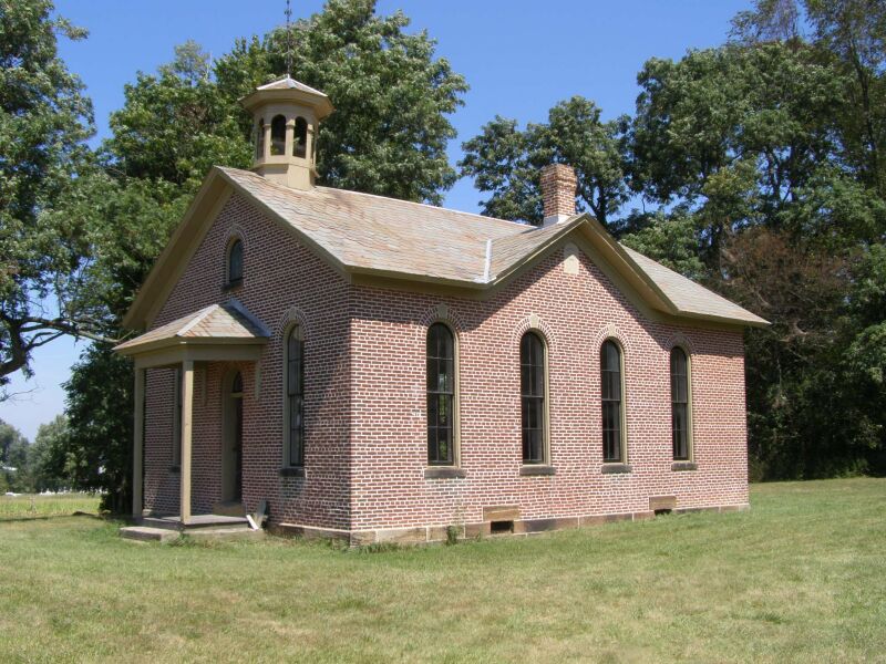
Boyd School
Monument and historic site · National Register of Historic Places · 2.1 mi
Historic, Italianate style school house in Holmes County, Ohio


Amish & Mennonite Heritage Center
Museum · 1.5 mi
Heritage center in Berlin, Ohio, United States

Parks, trails and playgrounds1

Restaurants and cafes2

Berlin Farmstead
Diner · American · 1.0 mi
4757 Township Road 366
Mo-Th 11:00-19:00; Fr-Sa 07:00-20:00

Where to stay4


History
The village of Berlin–the oldest existing village in Holmes County–was first planned on July 2, 1816, by John Swigert, a native of Berlin, Germany. Swigert's plan provided for 108 lots to be arrayed along two streets, one north–south and the other east–west. Another early settler, Joseph Troyer, hailed from Berlin, Pennsylvania, and together Swigert and Troyer bestowed upon the new settlement the shared name of their respective home towns. Berlin is located at a high point in Holmes County, and local legend holds that Swigert chose the site because, thus situated, the town could be more readily defended against Indian attack.
A large share of the early settlers of the Berlin area were of German or Swiss ancestry and came to Ohio from Pennsylvania.
In 1818, a school was established in Berlin and in 1822 a post office. These were soon followed by Methodist, Presbyterian, Baptist and Mennonite churches. Later, Amish settlers began to arrive. Berlin enjoyed commercial and industrial growth, and during the 19th century was home to machine shops, a foundry, blacksmith shops, a hat factory, hotels, an auction house, and a variety of retail establishments. Berlin was described in 1833 as having 21 residential houses, two stores, two taverns and a physician.
From the History section of Berlin, Holmes County, Ohio on Wikipedia, under CC BY-SA 4.0.
Churches and places of worship4
Shopping3
Gas and EV charging2
Schools, colleges and libraries11
Buckeye Career Center Annex-Hiland Satellite
School · 0.5 mi
5200 State Route 39, Millersburg
Map of Berlin
30 places. The map loads OpenStreetMap tiles when you open it.
Climate by month
Monthly table
| Month | High | Low | Rain | Snow |
|---|---|---|---|---|
| Jan | 36°F | 18°F | 2.9 in | 7.3 in |
| Feb | 39°F | 19°F | 2.1 in | 4.8 in |
| Mar | 49°F | 27°F | 3.1 in | 2.9 in |
| Apr | 62°F | 36°F | 3.9 in | 0.2 in |
| May | 72°F | 47°F | 4.2 in | 0.0 in |
| Jun | 80°F | 56°F | 4.9 in | 0.0 in |
| Jul | 84°F | 60°F | 4.2 in | 0.0 in |
| Aug | 82°F | 58°F | 3.4 in | 0.0 in |
| Sep | 76°F | 51°F | 3.3 in | 0.0 in |
| Oct | 65°F | 40°F | 3.1 in | 0.0 in |
| Nov | 52°F | 30°F | 2.8 in | 0.7 in |
| Dec | 40°F | 24°F | 2.9 in | 4.2 in |
U.S. Climate Normals 1991-2020 for Millersburg Hcn (6 mi away), NOAA NCEI.
People and cost of living
American Community Survey 5-year estimates, 2020-2024, U.S. Census Bureau. Estimates have margins of error, larger for small towns.
Disaster history
Holmes County has had 8 federal disaster declarations since 2000, most often for severe storms.
- 2020-03-31: Covid-19 Pandemic (Biological)
- 2020-03-13: Covid-19 (Biological)
- 2012-06-30: Severe Storms (Severe Storm)
- 2008-10-24: Severe Wind Storm Associated With Tropical Depression Ike (Severe Storm)
- 2005-09-13: Hurricane Katrina Evacuation (Hurricane)
- 2005-02-15: Severe Winter Storms, Flooding, And Mudslides (Severe Storm)
OpenFEMA disaster declarations summaries.
Getting there and nearby towns
Harry Clever Field (PHD) is the nearest airport with scheduled flights listed in OpenStreetMap, 21 miles away.
- Dover 17 mi east, about 27 min by car
- Wooster 20 mi north, about 32 min by car
- New Philadelphia 20 mi east, about 31 min by car
- Coshocton 20 mi south, about 33 min by car
- Massillon 22 mi northeast, about 35 min by car
- Canton 29 mi northeast, about 46 min by car
- New Franklin 30 mi north, about 48 min by car
- North Canton 31 mi northeast, about 49 min by car
- Green 33 mi northeast, about 53 min by car
- Wadsworth 33 mi north, about 53 min by car
Drive times are estimates from straight-line distance, not routes.
Local news
Headlines from INDB, the NEMICO news database.
Reviews, tips and questions
Loading what members have shared...
Sources and licences
- NCES EDGE (Public domain): public schools
- NOAA NCEI U.S. Climate Normals 1991-2020 (Public domain): climate by month
- OpenFEMA (Public domain): disaster declarations
- OpenStreetMap contributors (ODbL 1.0): places, airports, map data
- U.S. Census Bureau (Public domain): population, income, housing, education, commute
- Wikidata (CC0 1.0): elevation, founding date, time zone, website, landmarks and historic places
- Wikimedia Commons (see each image): photos
- Wikipedia (CC BY-SA 4.0): overview and history text
Photo credits
- Main St 2018-11-06 986, Chris Light, CC BY-SA 4.0
- Boyd School P9020161, Chris Light ( talk ), CC BY-SA 3.0
- Amish and Mennonite Heritage Center, photoswelike, CC BY-SA 2.0
Page built October 30, 2026. Spotted a mistake? Tell us or suggest a place.