
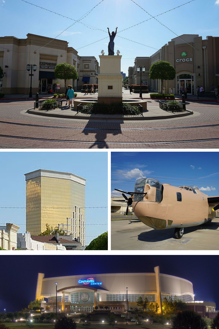


Bossier City, Louisiana
Bossier City is a city of 62,901 people in Bossier Parish, Louisiana, founded in 1907.
Why visit Bossier City
Townapedia lists 64 museums and landmarks, 28 parks and trails, 162 places to eat, 44 places to stay and 13 attractions in and around town.
Highlights include Kansas City Southern Railroad Bridge, Cross Bayou, Shreveport Municipal Memorial Auditorium, A.C. Steere Elementary School and Bossier High School.
August is the warmest month, with average highs of 95°F; January lows average 39°F.
Weather in Bossier City
Forecast from the National Weather Service. Full forecast
About Bossier City
Bossier City is a city in Bossier Parish, Louisiana, United States. The population was 62,701 at the 2020 census. Located on the eastern bank of the Red River, Bossier City is closely tied economically and socially to its sister city, Shreveport, on the western bank. It is the second-most populous city in the Shreveport–Bossier City metropolitan area.
From the Wikipedia article Bossier City, Louisiana (this version), under CC BY-SA 4.0.
Things to do13

Kansas City Southern Railroad Bridge, Cross Bayou
Bridge · National Register of Historic Places · 5.5 mi
Bridge in Shreveport, LA

Shreveport Municipal Memorial Auditorium
Cinema and theater · National Register of Historic Places · 5.8 mi
Theater and meeting hall in Shreveport, Louisiana, United States

Bossier City Farmers Market
Farm and orchard · 2.8 mi
2950 East Texas Street, Bossier City
Sa 09:00-13:00

Shreveport Aquarium
Zoo and aquarium · 5.2 mi
Aquarium located in Shreveport, Louisiana, United States
Long-Allen Bridge (Shreveport)
Bridge · 5.1 mi
Truss bridge in Shreveport.

Louisiana State University Shreveport
School · 7.3 mi
Public university in Shreveport, Louisiana
RiverView Theater
Cinema and theater · 5.2 mi
Theater and performing arts center in RiverView Park in Shreveport, Louisiana, United States
Regal Louisiana Boardwalk Stadium 14 & IMAX
Cinema and theater · 4.9 mi
2 River Colony Drive, Bossier City
1 more on the map.
Museums and landmarks64

A.C. Steere Elementary School
Monument and historic site · National Register of Historic Places · 5.5 mi
Elementary school
4009 Youree Drive, Shreveport


Bossier High School
Monument and historic site · National Register of Historic Places · 4.3 mi
High school in Bossier City, Louisiana, United States
777 Bearkat Drive, Bossier City
B'Nai Zion Temple
Monument and historic site · National Register of Historic Places · 5.3 mi
Reform synagogue in New Orleans, Louisiana, United States
Bossier City Municipal Building
Monument and historic site · National Register of Historic Places · 4.4 mi
City hall in Bossier City, Louisiana
Bossier High School
Monument and historic site · National Register of Historic Places · 4.7 mi
School building in Bossier City, Louisiana
C. E. Byrd High School
Monument and historic site · National Register of Historic Places · 6.0 mi
American public high school
Central Fire Station
Monument and historic site · National Register of Historic Places · 5.7 mi
Fire station in Shreveport, Louisiana
Central High School
Monument and historic site · National Register of Historic Places · 6.5 mi
School in Shreveport, Louisiana (1917–1950)
Huey P. Long House
Monument and historic site · National Register of Historic Places · 7.3 mi
House in Louisiana, United States of America
Huey P. Long House
Monument and historic site · National Register of Historic Places · 5.6 mi
Historic house in Louisiana, United States
Jefferson Hotel
Monument and historic site · National Register of Historic Places · 5.5 mi
Listed on the NRHP in Shreveport, Louisiana, United States
Masonic Temple
Monument and historic site · National Register of Historic Places · 5.4 mi
Masonic temple in Louisiana, United States of America
52 more on the map.
Parks, trails and playgrounds28



Marie and Charles Hamel Park
Park · 4.1 mi
Clyde Fant Parkway and Island Park Boulevard

16 more on the map.
Restaurants and cafes162

Another Broken Egg Cafe
Restaurant · Brunch · 4.3 mi
3107 Airline Drive, Bossier City
Mo-Su 07:00-14:00
Asian Cafe
Restaurant · Asian · 5.0 mi
4200 Airline Drive, Bossier City
Tu-Sa 11:00-21:00, Su 11:30-21:00
Captain La Fish & Chicken
Restaurant · Seafood · 4.1 mi
1770 East Texas Street, Bossier City
Su-Th 10:00-22:00, Fr-Sa 10:00-12:00
Chili's
Restaurant · Tex-Mex · 2.7 mi
3025 East Texas Street, Bossier City
Su-Th 10:45-23:00, Fr-Sa 10:45-24:00
China Flag Buffet
Restaurant · Chinese · 3.2 mi
2121 Airline Drive, Bossier City
Mo-Th 11:00-21:30, Fr-Sa 11:00-22:00, Su 11:00-21:30
Deli-Casino Sandwich Shoppe
Restaurant · Sandwich · 4.9 mi
637 East Kings Highway, Shreveport
Mo-Sa 10:30-15:00
Divine 9 Cuisine
Restaurant · Vietnamese · 2.4 mi
1964 Airline Drive, Bossier City
Mo-Sa 10:00-21:00, Su 12:00-19:00
Don Juanz Baja Beach Tacos
Restaurant · Mexican · 3.5 mi
2333 Airline Drive, Bossier City
Tu-Su 11:00-21:00
Don Lucio's Bar & Grill
Restaurant · Mexican · 5.4 mi
4615 Highway 80, Haughton
Mo-Th 11:00-21:30, Fr 11:00-22:00, Sa-Su 11:00-21:30
150 more on the map.
Where to stay44
Comfort Suites Bossier City - Shreveport East
Motel and hotel · 2.2 mi
7950 East Texas Street, Bossier City
Courtyard Shreveport-Bossier City/Louisiana Boardwalk
Motel and hotel · 4.9 mi
100 Boardwalk Boulevard, Bossier City
Holiday Inn Express & Suites Bossier City
Motel and hotel · 2.3 mi
7970 East Texas Street, Bossier City
Holiday Inn Express & Suites Shreveport - Downtown
Motel and hotel · 5.2 mi
201 Lake Street, Shreveport
Horseshoe Bossier City Hotel & Casino - A Caesars Rewards Destination
Motel and hotel · 4.9 mi
711 Horseshoe Boulevard, Bossier City
Churches and places of worship80
Antioch Baptist Church
Church · National Register of Historic Places · 5.9 mi
Holy Trinity Catholic Church
Church · National Register of Historic Places · 5.6 mi
Kings Highway Christian Church
Church · National Register of Historic Places · 6.1 mi
St. Mark's Episcopal Church
Church · National Register of Historic Places · 5.7 mi
Shopping31
Williams Equipment & Supply of Louisiana
Hardware store · 1.9 mi
3514 East Texas Street, Bossier City
Gas and EV charging29
Schools, colleges and libraries53
Bossier Parish Libraries - Aulds Branch
Library · 3.0 mi
3950 Wayne Avenue, Bossier City
Bossier Parish Libraries - Central Complex
Library · 3.5 mi
7204 Hutchison Drive, Bossier City
Bossier Parish Libraries - East 80 Branch
Library · 3.4 mi
1050 Bellevue Road, Haughton
Bossier Parish School for Technology & Innovative Learning
School · 3.0 mi
1020 Innovation Drive, Bossier City
Healthcare22
Greenacres Chiropractic
Clinic and pharmacy · 3.8 mi
925 Benton Road, Bossier City
Lagniappe Chiropractic
Clinic and pharmacy · 4.9 mi
4200 Airline Drive, Bossier City
Ochsner/LSU Health Urgent Care
Clinic and pharmacy · 3.1 mi
2113 Airline Drive, Bossier City
Map of Bossier City
250 places. The map loads OpenStreetMap tiles when you open it.
Climate by month
Monthly table
| Month | High | Low | Rain |
|---|---|---|---|
| Jan | 59°F | 39°F | 4.4 in |
| Feb | 62°F | 42°F | 4.3 in |
| Mar | 70°F | 49°F | 4.7 in |
| Apr | 78°F | 56°F | 4.7 in |
| May | 85°F | 66°F | 3.8 in |
| Jun | 92°F | 73°F | 4.4 in |
| Jul | 95°F | 76°F | 3.5 in |
| Aug | 95°F | 75°F | 2.6 in |
| Sep | 90°F | 68°F | 3.3 in |
| Oct | 79°F | 57°F | 4.4 in |
| Nov | 68°F | 47°F | 4.0 in |
| Dec | 60°F | 40°F | 4.8 in |
U.S. Climate Normals 1991-2020 for Shreveport Dwtn Ap (5 mi away), NOAA NCEI.
People and cost of living
American Community Survey 5-year estimates, 2020-2024, U.S. Census Bureau. Estimates have margins of error, larger for small towns.
Disaster history
Bossier Parish has had 29 federal disaster declarations since 2000, most often for hurricanes.
- 2026-01-24: Severe Winter Storm (Winter Storm)
- 2024-09-10: Tropical Storm Francine (Hurricane)
- 2021-09-13: Tropical Storm Nicholas (Coastal Storm)
- 2021-08-29: Hurricane Ida (Hurricane)
- 2021-08-27: Tropical Storm Ida (Hurricane)
- 2021-03-09: Severe Winter Storms (Severe Ice Storm)
OpenFEMA disaster declarations summaries.
Getting there and nearby towns
Shreveport Downtown Airport (DTN) is the nearest airport with scheduled flights listed in OpenStreetMap, 5 miles away.
- Red Chute 4 mi northeast, about 7 min by car
- Eastwood 6 mi northeast, about 10 min by car
- Shreveport 9 mi southwest, about 14 min by car
- Haughton 9 mi east, about 14 min by car
- Lakeview 10 mi west, about 16 min by car
- Benton 12 mi northwest, about 20 min by car
- Blanchard 14 mi west, about 23 min by car
- Doyline 14 mi east, about 22 min by car
- Greenwood 19 mi west, about 30 min by car
- Stonewall 20 mi southwest, about 31 min by car
Drive times are estimates from straight-line distance, not routes.
Local news
Headlines from INDB, the NEMICO news database.
Reviews, tips and questions
Loading what members have shared...
Sources and licences
- NCES EDGE (Public domain): public schools
- NOAA NCEI U.S. Climate Normals 1991-2020 (Public domain): climate by month
- OpenFEMA (Public domain): disaster declarations
- OpenStreetMap contributors (ODbL 1.0): places, airports, map data
- U.S. Census Bureau (Public domain): population, income, housing, education, commute
- Wikidata (CC0 1.0): elevation, founding date, time zone, website, landmarks and historic places
- Wikimedia Commons (see each image): photos
- Wikipedia (CC BY-SA 4.0): overview and history text
Photo credits
- Bossier City Collage, TheTexasNationalist99, CC BY-SA 4.0
- Fried shrimp and catfish at Big O's, Bossier City, Shreveport-Bossier: Louisiana's Other Side, CC BY 2.0
- Divinely-inspired tartar sauce at Big O's, Bossier City (5755954932), Shreveport-Bossier Convention and Tourist Bureau, CC BY 2.0
- Bossier HS - NRHP - Bearcat Drive, Gwmackey, CC BY-SA 3.0
- English Phone Box in Barksdale AF Base, Shreveport, Louisiana, Gary Todd, CC0
- Convair B-58 "Rocket Sled" (35069305794), Gary Todd from Xinzheng, China, CC0
- 486th Bombardment Group Memorial (Barksdale), Gary Todd, CC0
- US House LA-5 candidate Ryan Trundle at BPCC 22, Timothy Holdiness, CC BY-SA 4.0
- US House LA-5 candidate Ryan Trundle at BPCC 37, Timothy Holdiness, CC BY-SA 4.0
- US House LA-5 candidate Ryan Trundle at BPCC 15, Timothy Holdiness, CC BY-SA 4.0
- US House LA-5 candidate Ryan Trundle at BPCC 34, Timothy Holdiness, CC BY-SA 4.0
- US House LA-5 candidate Ryan Trundle at BPCC 30, Timothy Holdiness, CC BY-SA 4.0
- US House LA-5 candidate Ryan Trundle at BPCC 29, Timothy Holdiness, CC BY-SA 4.0
- US House LA-5 candidate Ryan Trundle at BPCC 13, Timothy Holdiness, CC BY-SA 4.0
- US House LA-5 candidate Ryan Trundle at BPCC 27, Timothy Holdiness, CC BY-SA 4.0
- US House LA-5 candidate Ryan Trundle at BPCC 03, Timothy Holdiness, CC BY-SA 4.0
- US House LA-5 candidate Ryan Trundle at BPCC 23, Timothy Holdiness, CC BY-SA 4.0
- US House LA-5 candidate Ryan Trundle at BPCC 01, Timothy Holdiness, CC BY-SA 4.0
- US House LA-5 candidate Ryan Trundle at BPCC 18, Timothy Holdiness, CC BY-SA 4.0
- US House LA-5 candidate Ryan Trundle at BPCC 11, Timothy Holdiness, CC BY-SA 4.0
- US House LA-5 candidate Ryan Trundle at BPCC 09, Timothy Holdiness, CC BY-SA 4.0
- US House LA-5 candidate Ryan Trundle at BPCC 26, Timothy Holdiness, CC BY-SA 4.0
- US House LA-5 candidate Ryan Trundle at BPCC 07, Timothy Holdiness, CC BY-SA 4.0
- US House LA-5 candidate Ryan Trundle at BPCC 17, Timothy Holdiness, CC BY-SA 4.0
- US House LA-5 candidate Ryan Trundle at BPCC 12, Timothy Holdiness, CC BY-SA 4.0
- US House LA-5 candidate Ryan Trundle at BPCC 32, Timothy Holdiness, CC BY-SA 4.0
- US House LA-5 candidate Ryan Trundle at BPCC 04, Timothy Holdiness, CC BY-SA 4.0
- US House LA-5 candidate Ryan Trundle at BPCC 33, Timothy Holdiness, CC BY-SA 4.0
- US House LA-5 candidate Ryan Trundle at BPCC 36, Timothy Holdiness, CC BY-SA 4.0
- US House LA-5 candidate Ryan Trundle at BPCC 20, Timothy Holdiness, CC BY-SA 4.0
- US House LA-5 candidate Ryan Trundle at BPCC 31, Timothy Holdiness, CC BY-SA 4.0
- US House LA-5 candidate Ryan Trundle at BPCC 38, Timothy Holdiness, CC BY-SA 4.0
- US House LA-5 candidate Ryan Trundle at BPCC 14, Timothy Holdiness, CC BY-SA 4.0
- US House LA-5 candidate Ryan Trundle at BPCC 10, Timothy Holdiness, CC BY-SA 4.0
- US House LA-5 candidate Ryan Trundle at BPCC 21, Timothy Holdiness, CC BY-SA 4.0
- US House LA-5 candidate Ryan Trundle at BPCC 08, Timothy Holdiness, CC BY-SA 4.0
- US House LA-5 candidate Ryan Trundle at BPCC 06, Timothy Holdiness, CC BY-SA 4.0
- US House LA-5 candidate Ryan Trundle at BPCC 19, Timothy Holdiness, CC BY-SA 4.0
- US House LA-5 candidate Ryan Trundle at BPCC 02, Timothy Holdiness, CC BY-SA 4.0
- US House LA-5 candidate Ryan Trundle at BPCC 24, Timothy Holdiness, CC BY-SA 4.0


Page built October 30, 2026. Spotted a mistake? Tell us or suggest a place.