
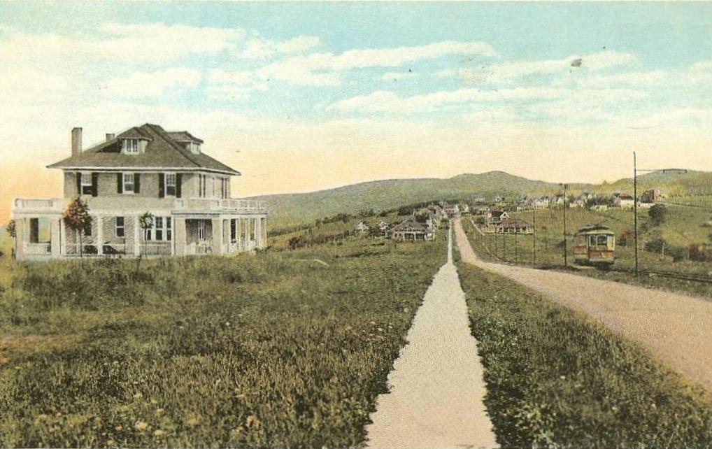


Braddock Heights, Maryland
Braddock Heights is a community of 2,892 people in Frederick County, Maryland.
Why visit Braddock Heights
Townapedia lists 14 museums and landmarks, 9 parks and trails, 18 places to eat and 5 attractions in and around town.
Highlights include Crum Road Bridge, Way Off Broadway Dinner Theatre, Airview Historic District and Bennies Hill Road Bridge.
July is the warmest month, with average highs of 89°F; January lows average 26°F.
Weather in Braddock Heights
Forecast from the National Weather Service. Full forecast
About Braddock Heights
Braddock Heights is an unincorporated community and census-designated place (CDP) in Frederick County, Maryland, United States. The population was 2,608 at the 2010 census. The local ZIP codes are 21714 (post office boxes only) and 21703.
From the Wikipedia article Braddock Heights, Maryland (this version), under CC BY-SA 4.0.
Things to do5
Crum Road Bridge
Bridge · National Register of Historic Places · 3.0 mi
Bridge in United States of America

Way Off Broadway Dinner Theatre
Cinema and theater · 2.4 mi
Dinner theater and children's theater in Frederick, Maryland

Warehouse Cinemas
Cinema and theater · 2.2 mi
1301 West Patrick Street, Frederick
Museums and landmarks14

Airview Historic District
Monument and historic site · National Register of Historic Places · 2.9 mi
Historic district in Middletown, Maryland

Bennies Hill Road Bridge
Bridge · National Register of Historic Places · 4.1 mi
Steel bowstring arch bridge over Catoctin Creek near Middletown, Maryland, USA

George Widrick House
Monument and historic site · National Register of Historic Places · 2.9 mi
Historic house in Maryland, United States

George Willard House
Monument and historic site · National Register of Historic Places · 3.9 mi
Jefferson, Maryland, NRHP-listed

Henry Smeltzer Farmstead
Monument and historic site · National Register of Historic Places · 3.8 mi
Human settlement in Frederick County, Maryland, United States of America

Highland Lodge
Monument and historic site · National Register of Historic Places · 1.2 mi
Historic building in Maryland, USA

Hood College
Monument and historic site · National Register of Historic Places · 4.1 mi
Liberal arts college in Frederick, Maryland, United States

Linden Grove
Monument and historic site · National Register of Historic Places · 3.3 mi
Building in Maryland, United States

Middletown Historic District
Monument and historic site · National Register of Historic Places · 3.6 mi
Listed on the NRHP in Frederick County, Maryland
One-Million-Liter Test Sphere
Monument and historic site · National Register of Historic Places · 3.8 mi
Building in Maryland, United States

Rich Mountain
Monument and historic site · National Register of Historic Places · 0.6 mi
Building in Maryland, United States


Schifferstadt
Monument and historic site · National Register of Historic Places · 3.7 mi
Oldest standing house in Frederick, Maryland, United States
2 more on the map.
Parks, trails and playgrounds9

Restaurants and cafes18

Aleko's Village Cafe
Restaurant · Greek · 2.2 mi
4304 Old National Pike, Middletown
Mo-Th 11:00-20:00 || Fr-Sa 11:00-20:30

Panda Sushi
Restaurant · Japanese · 2.3 mi
1220 West Patrick Street, Frederick
Mo-Th 11:00-15:00,17:00-21:00; Fr 11:00-15:00,17:00-22:00; Sa...
Saffron Grill & Bar
Restaurant · Indian · 2.0 mi
1301 West Patrick Street, Frederick
Mo-Sa 11:00-15:00,17:00-22:00; Su 12:00-21:00
The Capital Crave
Restaurant · Burger, Pasta, Sandwich, Salad, Pizza · 1.8 mi
5901 Old National Pike


Domino's
Fast food · Pizza · 2.1 mi
4316 Old National Pike, Middletown
Mo-Th 10:30-23:00; Fr-Sa 10:30-24:00; Su 10:30-23:00
6 more on the map.
History
Braddock Heights is located at an elevation of 950 feet (290 m) atop Braddock Mountain (as Catoctin Mountain is locally known) near the pass at Braddock Springs, so named after British General Edward Braddock and Lt. Colonel George Washington's use of the mountain pass on their way to Fort Duquesne during the French and Indian War on April 29, 1755. During the Civil War, Braddock Heights was the site of a minor cavalry battle between generals J.E.B. Stuart (CSA) and Alfred Pleasonton (USA) on September 13, 1862; it was at that time known as "Fairview Pass". One mile east of Braddock Heights, near the base of Braddock Mountain, are the older communities of Clifton and Old Braddock.
The picturesque view of the city of Frederick from Old Braddock, also known as "Fairview", elevation 550 feet (170 m), was the inspiration for Oliver Wendell Holmes Sr. to record in his 1862 journal:
In approaching Frederick the singular beauty of its clustered spires struck me very much, so that I was not surprised to find Fair View laid down about this point on a railroad map. I wish some wandering photographer would take a picture of the place, a stereoscopic one, if possible, to show how gracefully, how charmingly, its group of steeples nestles among the Maryland hills. The town has a poetical look from a distance, as if seers and dreamers might dwell there.
From the History section of Braddock Heights, Maryland on Wikipedia, under CC BY-SA 4.0.
Churches and places of worship8
Shopping5
District 40
Shopping center · 2.1 mi
1301 West Patrick Street, Frederick
Gas and EV charging4
Schools, colleges and libraries37
Carroll Creek Montessori Public Charter
School · 4.7 mi
7215 Corporate Court, Frederick
Frederick County Career & Technology Center
School · 5.1 mi
7922 Opossumtown Pike, Frederick
Healthcare1
Map of Braddock Heights
101 places. The map loads OpenStreetMap tiles when you open it.
Climate by month
Monthly table
| Month | High | Low | Rain |
|---|---|---|---|
| Jan | 43°F | 26°F | 2.6 in |
| Feb | 48°F | 28°F | 3.0 in |
| Mar | 55°F | 36°F | 3.7 in |
| Apr | 69°F | 45°F | 3.5 in |
| May | 77°F | 55°F | 4.0 in |
| Jun | 85°F | 63°F | 4.3 in |
| Jul | 89°F | 68°F | 3.9 in |
| Aug | 87°F | 66°F | 2.9 in |
| Sep | 80°F | 59°F | 5.8 in |
| Oct | 69°F | 47°F | 3.3 in |
| Nov | 56°F | 38°F | 2.7 in |
| Dec | 47°F | 31°F | 4.0 in |
U.S. Climate Normals 1991-2020 for Frederick Police Brks (3 mi away), NOAA NCEI.
People and cost of living
American Community Survey 5-year estimates, 2020-2024, U.S. Census Bureau. Estimates have margins of error, larger for small towns.
Disaster history
Frederick County has had 13 federal disaster declarations since 2000, most often for hurricanes.
- 2026-01-24: Severe Winter Storm (Winter Storm)
- 2020-03-26: Covid-19 Pandemic (Biological)
- 2020-03-13: Covid-19 (Biological)
- 2018-06-25: Severe Storms And Flooding (Severe Storm)
- 2016-03-04: Severe Winter Storm And Snowstorm (Snowstorm)
- 2012-11-20: Hurricane Sandy (Hurricane)
OpenFEMA disaster declarations summaries.
Getting there and nearby towns
Frederick Municipal Airport (FDK) is the nearest airport with scheduled flights listed in OpenStreetMap, 6 miles away.
- Ballenger Creek 4 mi southeast, about 7 min by car
- Frederick 5 mi northeast, about 8 min by car
- Adamstown 7 mi south, about 12 min by car
- Bartonsville 8 mi east, about 12 min by car
- Urbana 10 mi southeast, about 16 min by car
- Linganore 10 mi east, about 17 min by car
- Boonsboro 11 mi northwest, about 18 min by car
- Green Valley 14 mi east, about 23 min by car
- Clarksburg 18 mi southeast, about 29 min by car
- Damascus 19 mi southeast, about 30 min by car
Drive times are estimates from straight-line distance, not routes.
Local news
Headlines from INDB, the NEMICO news database.
Reviews, tips and questions
Loading what members have shared...
Sources and licences
- NCES EDGE (Public domain): public schools
- NOAA NCEI U.S. Climate Normals 1991-2020 (Public domain): climate by month
- OpenFEMA (Public domain): disaster declarations
- OpenStreetMap contributors (ODbL 1.0): places, airports, map data
- U.S. Census Bureau (Public domain): population, income, housing, education, commute
- Wikidata (CC0 1.0): elevation, founding date, time zone, website, landmarks and historic places
- Wikimedia Commons (see each image): photos
- Wikipedia (CC BY-SA 4.0): overview and history text
Photo credits
- Jefferson Blvd Mid, Unknown author Unknown author, Public domain
- Stonebraker and Harbaugh, Shafer Building, Acroterion, CC BY-SA 4.0
- Bennies Hill Road Bridge1, Acroterion, CC BY-SA 4.0
- Highland Lodge, Bradenw1, CC BY-SA 3.0
- Crum Road Bridge MD HABS1, Larry Nye, HABS photographer, Public domain
- George Willard House, Acroterion, CC BY-SA 4.0
- Middletown, Maryland historic district, Acroterion, CC BY-SA 4.0
- Airview HD, Acroterion, CC BY-SA 4.0
- Alumnae Hall Hood College MD1, Acroterion, CC BY-SA 4.0
- Rich Mountain Frederick MD1, Acroterion, CC BY-SA 4.0
- Linden Grove, Frederick, Maryland, Acroterion, CC BY-SA 4.0
- George Widrick Historic Home, Earthtojoanna, CC BY-SA 3.0
- Shafer's Mill, Acroterion, CC BY-SA 4.0
- Schifferstadt, Acroterion, CC BY-SA 4.0
- Saint John's Church Hagerstown 2011 0410, Cmagha, CC0


Page built October 30, 2026. Spotted a mistake? Tell us or suggest a place.