


Brookneal, Virginia
Brookneal is a town of 1,300 people in Campbell County, Virginia, founded in 1802.
Why visit Brookneal
Townapedia lists 7 museums and landmarks, 5 places to eat and 1 attraction in and around town.
Highlights include Brookneal Historic District and Cat Rock Sluice of the Roanoke Navigation.
July is the warmest month, with average highs of 88°F; January lows average 24°F.
Weather in Brookneal
Forecast from the National Weather Service. Full forecast
About Brookneal
Brookneal is an incorporated town in Campbell County, Virginia, United States. The population was 1,090 as of the 2020 census. It is part of the Lynchburg metropolitan area.
From the Wikipedia article Brookneal, Virginia (this version), under CC BY-SA 4.0.
Things to do1

Museums and landmarks7

Brookneal Historic District
Monument and historic site · National Register of Historic Places · 0.6 mi
Historic district in Brookneal, Virginia
Cat Rock Sluice of the Roanoke Navigation
Monument and historic site · National Register of Historic Places · 0.5 mi
Place in Virginia listed on National Register of Historic Places

DeJarnette's Tavern
Monument and historic site · National Register of Historic Places · 3.8 mi
Historic commercial building in Virginia, United States
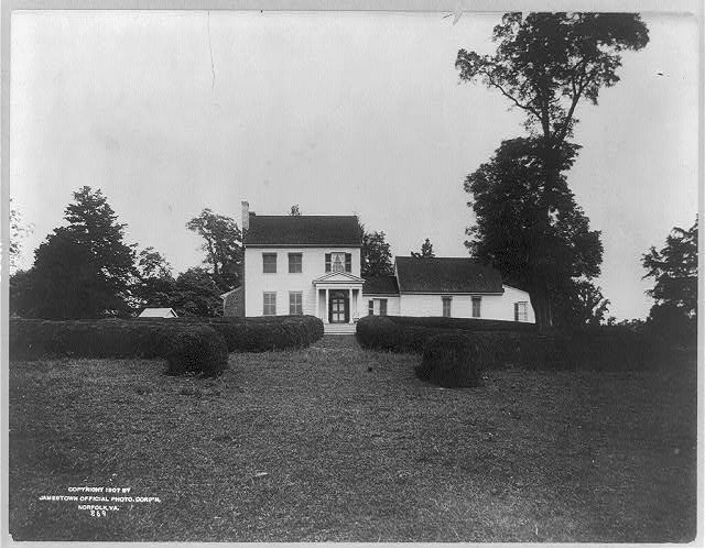


Red Hill Patrick Henry National Memorial
Monument and historic site · National Register of Historic Places · 3.3 mi
1,000 acres in Virginia (USA), maintained by the Patrick Henry Memorial Foundation

Restaurants and cafes5


China 8
Restaurant · Chinese · 0.8 mi
1313 Lynchburg Avenue, Brookneal

Burgers Shakes and Cream
Fast food · Burger, Hot Dog, Ice Cream · 0.5 mi
Closes 1 hour earlier in the winter
104 Lusardi Drive, Brookneal
Mo-Th 05:30-22:00; Fr, Sa 05:30-23:00; Su 07:00-22:00
Churches and places of worship2

History
On January 14, 1802, "Brooke Neal" was established by the Commonwealth of Virginia in Chapter 65 of the Acts of Assembly. It was named after John Brooke and his wife, Sarah (née Neal) Brooke, who established a tobacco warehouse which became known as "Brooke's Warehouse". It was located near the boat landing and ferry crossing on the Staunton River.
The "Town of Brookneal" was incorporated and a charter issued in 1908. Later to become the smallest incorporated town in the Central Virginia region, Brookneal served as the closest center of commerce for portions of Campbell, Charlotte, and Halifax counties. As transportation modes developed, Brookneal's location offered proximity to waterways, roads and railroads.
From the earliest days of settlement of the area by Europeans in the Colony of Virginia, through the Revolutionary War era, and extending through most of the first half of the 19th century in Virginia, waterways were a major transportation resource for commerce. Roads were primitive and poorly maintained. Upstream from the fall line, which marked the western reaches of the coastal plain of Virginia (and adjacent areas of North Carolina), canals and other improvements were constructed to aid navigation upriver by batteaux and another watercraft. In the later 19th century, railroads supplanted river transportation in the Piedmont region east of the mountains.
From the History section of Brookneal, Virginia on Wikipedia, under CC BY-SA 4.0.
Shopping6
Gas and EV charging2
Schools, colleges and libraries4
Healthcare2
Map of Brookneal
29 places. The map loads OpenStreetMap tiles when you open it.
Climate by month
Monthly table
| Month | High | Low | Rain | Snow |
|---|---|---|---|---|
| Jan | 48°F | 24°F | 3.7 in | 3.1 in |
| Feb | 52°F | 26°F | 2.8 in | 2.3 in |
| Mar | 60°F | 32°F | 4.0 in | 0.5 in |
| Apr | 71°F | 42°F | 3.4 in | 0.0 in |
| May | 78°F | 52°F | 4.8 in | 0.0 in |
| Jun | 86°F | 60°F | 4.1 in | 0.0 in |
| Jul | 88°F | 65°F | 4.3 in | 0.0 in |
| Aug | 87°F | 64°F | 3.5 in | 0.0 in |
| Sep | 81°F | 56°F | 4.3 in | 0.0 in |
| Oct | 70°F | 43°F | 3.8 in | 0.0 in |
| Nov | 60°F | 32°F | 3.6 in | 0.0 in |
| Dec | 51°F | 27°F | 3.7 in | 1.5 in |
U.S. Climate Normals 1991-2020 for Brookneal (1 mi away), NOAA NCEI.
People and cost of living
American Community Survey 5-year estimates, 2020-2024, U.S. Census Bureau. Estimates have margins of error, larger for small towns.
Disaster history
Campbell County has had 13 federal disaster declarations since 2000, most often for hurricanes.
- 2026-01-23: Severe Winter Storm (Winter Storm)
- 2025-04-04: Severe Winter Storms And Flooding (Severe Storm)
- 2021-05-10: Severe Winter Storms (Severe Ice Storm)
- 2020-04-02: Covid-19 Pandemic (Biological)
- 2020-03-13: Covid-19 (Biological)
- 2018-12-18: Tropical Storm Michael (Hurricane)
OpenFEMA disaster declarations summaries.
Getting there and nearby towns
Lynchburg Regional Airport (LYH) is the nearest airport with scheduled flights listed in OpenStreetMap, 24 miles away.
- Altavista 19 mi west, about 30 min by car
- Appomattox 23 mi north, about 36 min by car
- Timberlake 25 mi northwest, about 40 min by car
- Lynchburg 28 mi northwest, about 45 min by car
- Forest 29 mi northwest, about 46 min by car
- Madison Heights 29 mi north, about 47 min by car
- Blairs 34 mi southwest, about 54 min by car
- Amherst 37 mi north, about 1 h by car
- Danville 41 mi southwest, about 1 h by car
- Roxboro 45 mi south, about 1 h 15 min by car
Drive times are estimates from straight-line distance, not routes.
Local news
Headlines from INDB, the NEMICO news database.
Reviews, tips and questions
Loading what members have shared...
Sources and licences
- NCES EDGE (Public domain): public schools
- NOAA NCEI U.S. Climate Normals 1991-2020 (Public domain): climate by month
- OpenFEMA (Public domain): disaster declarations
- OpenStreetMap contributors (ODbL 1.0): places, airports, map data
- U.S. Census Bureau (Public domain): population, income, housing, education, commute
- Wikidata (CC0 1.0): elevation, founding date, time zone, website, landmarks and historic places
- Wikimedia Commons (see each image): photos
- Wikipedia (CC BY-SA 4.0): overview and history text
Photo credits
- Brookneal, Virginia - panoramio, Idawriter, CC BY-SA 3.0
- Rush east from Foundry, Brookneal, Nyttend, Public domain
- Brookneal, VA 24528, USA - panoramio, Idawriter, CC BY-SA 3.0
- Brookneal, VA 24528, USA - panoramio (1), Idawriter, CC BY-SA 3.0
- Brookneal Rescue Squad - panoramio, Idawriter, CC BY-SA 3.0
- Roanoke River by Brookneal, Nyttend, Public domain
- DeJarnettesTavern2005, Tim Ross, Public domain
- Red Hill Charlotte County Virginia 1907, Jamestown Official Photo Corp., Public domain
- West End Baptist Church - panoramio, Idawriter, CC BY-SA 3.0

Page built October 30, 2026. Spotted a mistake? Tell us or suggest a place.