


Why visit Brunswick
Townapedia lists 47 museums and landmarks, 73 parks and trails, 86 places to eat, 12 places to stay and 16 attractions in and around town.
Highlights include Androscoggin Swinging Bridge, Brunswick Falls, Peary–MacMillan Arctic Museum and Bowdoin College Museum of Art.
July is the warmest month, with average highs of 79°F; January lows average 12°F, and about 67 inches of snow fall in a normal year.
Weather in Brunswick
Forecast from the National Weather Service. Full forecast
About Brunswick
Brunswick is a census-designated place (CDP) in the town of Brunswick in Cumberland County, Maine, United States. The population was 15,175 at the 2010 census. It is part of the Portland–South Portland–Biddeford, Maine Metropolitan Statistical Area.
From the Wikipedia article Brunswick (CDP), Maine (this version), under CC BY-SA 4.0.
Things to do16
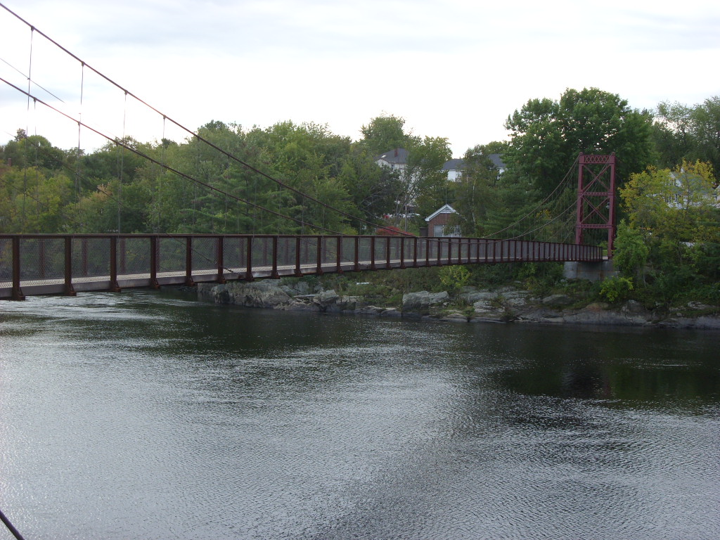
Androscoggin Swinging Bridge
Bridge · National Register of Historic Places · 2.6 mi
Pedestrian suspension bridge spanning the Androscoggin River in Maine

Brunswick Falls
Waterfall · 2.6 mi
Dam and waterfall in Brunswick and Topsham, Maine




4 more on the map.
Museums and landmarks47

Peary–MacMillan Arctic Museum
Museum · 1.7 mi
Museum in Brunswick, Maine
10 Polar Loop, Brunswick
Tu-Sa 10:00-17:00; Su 13:00-17:00; PH off
Bowdoin College Museum of Art
Museum · 1.8 mi
Museum at Bowdoin College in Brunswick, Maine
245 Maine Street, Brunswick
Tu-Sa 10:00-17:00; Th 10:00-20:30; Su 13:00-17:00; PH off; Nov...

Joshua L. Chamberlain Museum
Museum · 1.9 mi
Museum in Maine, United States
226 Maine Street, Brunswick
Tu-Sa 10:00-16:00
Pejepscot Historical Society
Museum · 2.1 mi
159 Park Row, Brunswick
Tu-Sa 10:00-12:00, 13:00-16:00; Su-Mo off; Oct Mo[2]-May Mo[-1]:...
Crystal Spring Farm
Monument and historic site · National Register of Historic Places · 2.7 mi
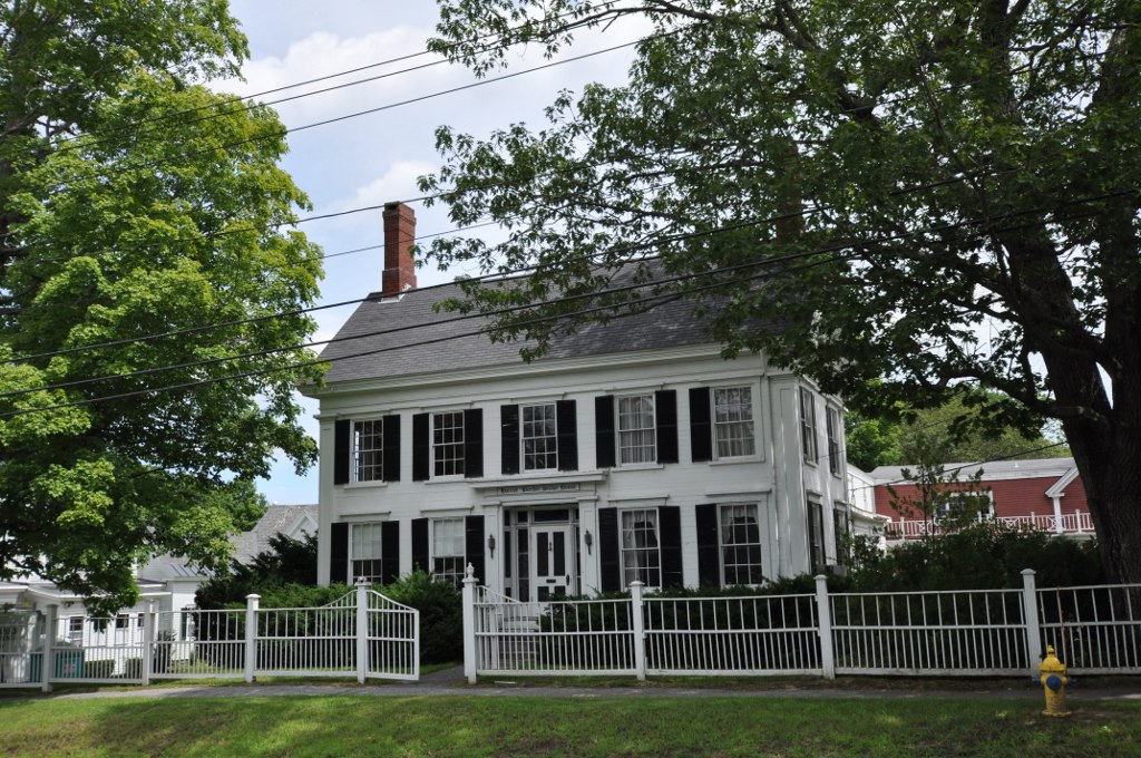
Harriet Beecher Stowe House
Monument and historic site · National Register of Historic Places · 2.0 mi
Historic house in Maine, United States
63 Federal Street, Brunswick

Topsham Historic District
Monument and historic site · National Register of Historic Places · 2.9 mi
Historic district in Topsham, Maine, United States

Cathance Water Tower
Monument and historic site · National Register of Historic Places · 4.5 mi
Water tower in Topsham, United States of America

Deacon Andrew Dunning House
Monument and historic site · National Register of Historic Places · 4.9 mi
Historic house in Maine, United States


Elijah Kellogg House
Monument and historic site · National Register of Historic Places · 3.8 mi
Historic house in Maine, United States

Federal Street Historic District
Monument and historic site · National Register of Historic Places · 2.0 mi
Historic district in Brunswick, Maine
Henry Boody House
Monument and historic site · National Register of Historic Places · 1.8 mi
Historic house in Maine, United States
35 more on the map.
Parks, trails and playgrounds73


Brunswick Lower Mall
Park · 2.0 mi
Park Row, Brunswick
Sep 26-Apr 30: Mo-Su 06:00-24:00; May 01-Sep 25: Mo-Su 06:00-10:00
Captain William A. Fitzgerald U.S.N. Recreation and Conservation Area
Park · 3.7 mi
Lindbergh Crossing, Brunswick
dawn-dusk


Whittier Field
Sports field and stadium · 1.6 mi
31 Bowker Street, Brunswick
61 more on the map.
Restaurants and cafes86

Asian Garden
Restaurant · Asian, Chinese, Japanese, Thai · 2.1 mi
168 Maine Street, Brunswick
Mo-Th 11:00-21:00; Fr-Sa 11:00-22:00; Su 12:00-21:00

Bohemian Coffee House & Deli
Cafe · Coffee Shop · 2.0 mi
4 Railroad Avenue, Brunswick
Mo-Sa 07:00-15:00; Su 08:00-14:00

Broadway Delicatessen
Restaurant · Breakfast, American, Sandwich · 2.2 mi
142 Maine Street, Brunswick
Th-Mo 08:00-14:00
Brunswick Diner
Restaurant · American, Breakfast, Lunch · 2.5 mi
101 Pleasant Street, Brunswick
Mo-Su 07:00-14:00

Byrnes Irish Pub
Bar and pub · American · 2.0 mi
16 Station Avenue, Brunswick
Mo-Th 11:00-20:00; Fr-Sa 11:00-21:00; Su off
Enoteca Athena
Restaurant · Italian, Greek · 2.3 mi
97 Maine Street, Brunswick
We-Sa 16:30-20:00; Su-Tu off

Gelato Fiasco
Ice cream · Coffee Shop, Ice Cream · 2.4 mi
74 Maine Street, Brunswick
Mo-Su 11:00-23:00
74 more on the map.
Where to stay12
Best Western Plus Brunswick/Bath
Motel and hotel · 1.9 mi
71 Gurnet Road, Brunswick
Churches and places of worship30
First Parish Church
Church · United Church Of Christ · National Register of Historic Places · 1.9 mi
217 Maine Street, Brunswick
East Harpswell Free Will Baptist Church
Church · National Register of Historic Places · 3.8 mi
St. Paul's Episcopal Church
Church · National Register of Historic Places · 2.2 mi
Saint John the Baptist Catholic Church
Church · Roman Catholic · 2.2 mi
39 Pleasant Street, Brunswick
Saint Paul's Episcopal Church
Church · Episcopal · 2.2 mi
27 Pleasant Street, Brunswick
Saint Charles Borromeo Catholic Church
Church · Roman Catholic · 2.5 mi
132 McKeen Street, Brunswick
Shopping35
Gas and EV charging6
Schools, colleges and libraries28
Healthcare7
Map of Brunswick
250 places. The map loads OpenStreetMap tiles when you open it.
Climate by month
Monthly table
| Month | High | Low | Rain | Snow |
|---|---|---|---|---|
| Jan | 30°F | 12°F | 3.5 in | 19.3 in |
| Feb | 33°F | 14°F | 3.5 in | 13.6 in |
| Mar | 41°F | 24°F | 4.1 in | 18.7 in |
| Apr | 53°F | 32°F | 4.3 in | 3.3 in |
| May | 64°F | 44°F | 4.1 in | 0.0 in |
| Jun | 73°F | 53°F | 4.2 in | 0.0 in |
| Jul | 79°F | 59°F | 3.5 in | 0.0 in |
| Aug | 78°F | 58°F | 3.3 in | 0.0 in |
| Sep | 70°F | 50°F | 4.2 in | 0.0 in |
| Oct | 58°F | 39°F | 6.0 in | 0.2 in |
| Nov | 47°F | 30°F | 5.2 in | 1.9 in |
| Dec | 37°F | 20°F | 4.3 in | 9.8 in |
U.S. Climate Normals 1991-2020 for Brunswick Nas 74392 (1 mi away), NOAA NCEI.
People and cost of living
American Community Survey 5-year estimates, 2020-2024, U.S. Census Bureau. Estimates have margins of error, larger for small towns.
Disaster history
Cumberland County has had 21 federal disaster declarations since 2000, most often for severe storms.
- 2024-05-24: Severe Winter Storm (Winter Storm)
- 2024-03-20: Severe Storms And Flooding (Severe Storm)
- 2023-09-14: Hurricane Lee (Hurricane)
- 2020-04-04: Covid-19 Pandemic (Biological)
- 2020-03-13: Covid-19 (Biological)
- 2018-01-02: Severe Storm And Flooding (Severe Storm)
OpenFEMA disaster declarations summaries.
Getting there and nearby towns
Brunswick Executive Airport (NHZ) is the nearest airport with scheduled flights listed in OpenStreetMap, 1 miles away.
- Topsham 4 mi north, about 6 min by car
- Bath 6 mi northeast, about 9 min by car
- Freeport 8 mi west, about 13 min by car
- Bowdoinham 9 mi north, about 15 min by car
- Lisbon Falls 10 mi northwest, about 16 min by car
- Lisbon 13 mi northwest, about 21 min by car
- Yarmouth 14 mi southwest, about 22 min by car
- Cousins Island 14 mi southwest, about 22 min by car
- Auburn 20 mi northwest, about 33 min by car
- Biddeford 38 mi southwest, about 1 h by car
Drive times are estimates from straight-line distance, not routes.
Local news
Headlines from INDB, the NEMICO news database.
Reviews, tips and questions
Loading what members have shared...
Sources and licences
- NCES EDGE (Public domain): public schools
- NOAA NCEI U.S. Climate Normals 1991-2020 (Public domain): climate by month
- OpenFEMA (Public domain): disaster declarations
- OpenStreetMap contributors (ODbL 1.0): places, airports, map data
- U.S. Census Bureau (Public domain): population, income, housing, education, commute
- Wikidata (CC0 1.0): elevation, founding date, time zone, website, landmarks and historic places
- Wikimedia Commons (see each image): photos
- Wikipedia (CC BY-SA 4.0): overview and history text
Photo credits
- Near Water Street boat landing, Brunswick, Maine, US (PPL3-Altered) julesvernex2, Jules Verne Times Two, CC BY-SA 4.0
- BrunswickME HenryBoodyHouse, Magicpiano, CC BY-SA 3.0
- BrunswickME ParkerCleavelandHouse, Magicpiano, CC BY-SA 3.0
- First Parish Church, Brunswick ME, ShastaMe, CC BY-SA 3.0
- JLC House 3-2006(1), Reroche at English Wikipedia, Public domain
- BrunswickME CrystalSpringFarm, Magicpiano, CC BY-SA 4.0
- Androscoggin Swinging Bridge, dougtone, CC BY-SA 2.0
- Daniel Holden House, Gerda Peterich, Public domain
- BrunswickME HarrietBeecherStoweHouse, Magicpiano, CC BY-SA 3.0
- BrunswickME JohnDunlapHouse, Magicpiano, CC BY-SA 3.0
- Downtown Brunswick, ME IMG 1967, Billy Hathorn, CC BY-SA 3.0
- HarpswellME UnionChurch, Magicpiano, CC BY-SA 3.0
- HarpswellME ElijahKelloggHouse, Magicpiano, CC BY-SA 4.0
- HarpswellME DeaconAndrewDunningHouse, Magicpiano, CC BY-SA 3.0
- HarpswellME EastHarpswellFreeWillBaptistChurch, Magicpiano, CC BY-SA 4.0
- CathanceWaterTower, Paul VanDerWerf, CC BY 2.0
- St Paul's Church, Brunswick, ME, ShastaMe, CC BY-SA 3.0
- TopshamME RandallHildrethHouse, Magicpiano, CC BY-SA 4.0
- HarpswellME MerriconeganFarm, Magicpiano, CC BY-SA 3.0
- Brunswick pennelville historic 10.07.2012, Dirk Ingo Franke, CC BY 3.0
- Blue Angels (27194765139), Paul VanDerWerf from Brunswick, Maine, USA, CC BY 2.0
- F22 Raptors (20936525310), Paul VanDerWerf from Brunswick, Maine, USA, CC BY 2.0
- Fat Albert (20936754398), Paul VanDerWerf from Brunswick, Maine, USA, CC BY 2.0
- Flip-Flops (20990533454), Paul VanDerWerf from Brunswick, Maine, USA, CC BY 2.0
- Father And Son (21534022371), Paul VanDerWerf from Brunswick, Maine, USA, CC BY 2.0
- P51 Mustang (21177390606), Paul VanDerWerf from Brunswick, Maine, USA, CC BY 2.0
- Right On! black fist painted on a white fence, Paul VanDerWerf, CC BY 2.0
- Blue Angels (36021437653), Paul VanDerWerf from Brunswick, Maine, USA, CC BY 2.0
- Over The Fence (36949378391), Paul VanDerWerf from Brunswick, Maine, USA, CC BY 2.0
- Pink Lady Slippers (34113083954), Paul VanDerWerf from Brunswick, Maine, USA, CC BY 2.0
- Fall Colors (30308512590), Paul VanDerWerf from Brunswick, Maine, USA, CC BY 2.0
- Dandelion Parachute (26929828080), Paul VanDerWerf from Brunswick, Maine, USA, CC BY 2.0
- Truck Box (15570256933), Paul VanDerWerf from Brunswick, Maine, USA, CC BY 2.0
- Truck Box (16003966949), Paul VanDerWerf from Brunswick, Maine, USA, CC BY 2.0
- Gentlemen, Start Your Engines (29901479842), Paul VanDerWerf from Brunswick, Maine, USA, CC BY 2.0
- Fairway (31844974200), Paul VanDerWerf from Brunswick, Maine, USA, CC BY 2.0
- Cozy - Flickr - Me in ME, Paul VanDerWerf from Brunswick, Maine, USA, CC BY 2.0
- Flight Deck Brewing 2, Seasider53, CC BY-SA 4.0
- Flight Deck Brewing 3, Seasider53, CC BY-SA 4.0
- Flight Deck Brewing 4, Seasider53, CC BY-SA 4.0


Page built October 30, 2026. Spotted a mistake? Tell us or suggest a place.