



Why visit Carter Lake
Townapedia lists 87 museums and landmarks, 15 parks and trails, 10 places to eat, 10 places to stay and 2 attractions in and around town.
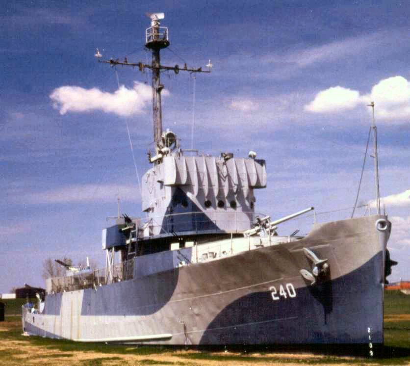
Highlights include Illinois Central Missouri River Bridge, Levi Carter Park, Freedom Park and USS Hazard.
July is the warmest month, with average highs of 88°F; January lows average 15°F, and about 27 inches of snow fall in a normal year.
Weather in Carter Lake
Forecast from the National Weather Service. Full forecast
About Carter Lake
Carter Lake is a city in Pottawattamie County, Iowa, United States. A suburb of Omaha, Nebraska, it sits surrounding the south and west sides of the region's major airport, Eppley Airfield. It is separated from the rest of Iowa by the Missouri River, effectively making it an exclave. The population was 3,791 at the 2020 census.
From the Wikipedia article Carter Lake, Iowa (this version), under CC BY-SA 4.0.
Things to do2

Illinois Central Missouri River Bridge
Bridge · 1.5 mi
Bridge in United States of America

Levi Carter Park
Monument and historic site · 1.1 mi
Park in the United States of America
Museums and landmarks87
Freedom Park
Monument and historic site · National Register of Historic Places · 1.2 mi
Park in Omaha, Nebraska
USS Hazard
Museum · National Register of Historic Places · 1.1 mi
1944 Admirable-class minesweeper
2497 Freedom Park Road, Omaha
Anderson Building
Monument and historic site · National Register of Historic Places · 2.9 mi
Commercial building in Omaha, Nebraska

Anheuser-Busch Beer Depot
Monument and historic site · National Register of Historic Places · 2.6 mi
Commercial building in Omaha, Nebraska
Aquila Court Building
Monument and historic site · National Register of Historic Places · 2.5 mi
Hotel building in Omaha, Nebraska
Barker Building
Monument and historic site · National Register of Historic Places · 2.4 mi
Omaha, Nebraska, on the U.S. National Register of Historic Places

Berkeley Apartments
Monument and historic site · National Register of Historic Places · 2.8 mi
Historic three-story apartment building in Omaha, Nebraska

Blackstone Hotel
Monument and historic site · National Register of Historic Places · 3.4 mi
Building in Omaha, Nebraska

Broomfield Rowhouse
Monument and historic site · National Register of Historic Places · 1.7 mi
Historic house in Nebraska, United States
Burlington Station
Monument and historic site · National Register of Historic Places · 2.7 mi
Train station in Omaha, Nebraska


Calvin Memorial Presbyterian Church
Monument and historic site · National Register of Historic Places · 1.5 mi
Church building in Omaha, United States of America
Christian Specht Building
Monument and historic site · National Register of Historic Places · 2.2 mi
Building in Nebraska, United States
75 more on the map.
Parks, trails and playgrounds15

Kountze Park
Park · 1.3 mi
Park in Nebraska, United States of America

3 more on the map.
Restaurants and cafes10

Dolomiti Pizzeria and Enoteca
Restaurant · Pizza · 1.5 mi
1105 North 13th Street, Omaha
Tu-Th 11:00-21:00; Fr-Sa 12:00-22:00; Su 12:00-21:00

Godfathers Pizza ToGo
Restaurant · 1.3 mi
We-Fr,Su,Mo 11:00-18:00, Tu,Su 11:00-17:00




North Food Court
Fast food · Chicken, Mexican, Pizza, Sandwich · 1.2 mi
KFC, Hugo's Tacos, Salads To Go, Hangar Express, Godfather's Pizza, Blimpie
4501 Abbott Drive, Omaha
History
Carter Lake is an example of the border irregularities of the United States, being the only city in Iowa located west of the Missouri River. A flood redirected the course of the river 1.25 mi (2 km) to the southeast in March 1877. The remnants of the old river course, called Saratoga Bend, became an oxbow lake, named Carter Lake. Soon after the formation of the lake, the site became a flourishing recreational area. It included "a boathouse at the foot of Locust street, hotels and club houses were numerous and the lake was the scene of many a pleasant rowing and fishing party."
After extensive litigation between Iowa and Nebraska, the Supreme Court of the United States ruled in 1892 that Carter Lake belonged to Iowa in Nebraska v. Iowa, 143 U.S. 359 (1892). Although the general rule is that state boundaries follow gradual changes in the course of a river, the Court ruled that an exception exists when a river avulses one of its bends. The Supreme Court made another ruling on the circumstances of Carter Lake in 1972 when it ruled on a boundary dispute between the two states in Nebraska v. Iowa, 406 U.S. 117 (1972).
From the History section of Carter Lake, Iowa on Wikipedia, under CC BY-SA 4.0.
Where to stay10
Churches and places of worship19
Gas and EV charging1
Schools, colleges and libraries45
Anne E. Nelson Early Learning Center
School · 3.4 mi
620 N. 8Th Street, Council Bluffs
Map of Carter Lake
189 places. The map loads OpenStreetMap tiles when you open it.
Climate by month
Monthly table
| Month | High | Low | Rain | Snow |
|---|---|---|---|---|
| Jan | 34°F | 15°F | 0.8 in | 7.2 in |
| Feb | 39°F | 19°F | 0.9 in | 7.8 in |
| Mar | 52°F | 30°F | 1.8 in | 3.0 in |
| Apr | 64°F | 41°F | 3.2 in | 1.0 in |
| May | 75°F | 53°F | 4.7 in | 0.1 in |
| Jun | 84°F | 63°F | 4.4 in | 0.0 in |
| Jul | 88°F | 68°F | 3.5 in | 0.0 in |
| Aug | 86°F | 66°F | 4.6 in | 0.0 in |
| Sep | 79°F | 56°F | 3.0 in | 0.0 in |
| Oct | 66°F | 43°F | 2.3 in | 0.5 in |
| Nov | 50°F | 30°F | 1.4 in | 1.7 in |
| Dec | 38°F | 20°F | 1.2 in | 5.8 in |
U.S. Climate Normals 1991-2020 for Omaha Eppley Airfield 72550 (2 mi away), NOAA NCEI.
People and cost of living
American Community Survey 5-year estimates, 2020-2024, U.S. Census Bureau. Estimates have margins of error, larger for small towns.
Disaster history
Pottawattamie County has had 16 federal disaster declarations since 2000, most often for severe storms.
- 2024-06-24: Severe Storms, Flooding, Straight-Line Winds, And Tornadoes (Severe Storm)
- 2024-05-24: Severe Storms, Tornadoes, And Flooding (Severe Storm)
- 2024-05-14: Severe Storms And Tornadoes (Tornado)
- 2020-03-23: Covid-19 Pandemic (Biological)
- 2020-03-13: Covid-19 (Biological)
- 2019-03-23: Severe Storms And Flooding (Flood)
OpenFEMA disaster declarations summaries.
Getting there and nearby towns
Eppley Airfield (OMA) is the nearest airport with scheduled flights listed in OpenStreetMap, 1 miles away.
- Council Bluffs 5 mi southeast, about 8 min by car
- Omaha 7 mi west, about 12 min by car
- Bellevue 10 mi south, about 16 min by car
- La Vista 11 mi southwest, about 17 min by car
- Papillion 13 mi southwest, about 21 min by car
- Chalco 14 mi southwest, about 22 min by car
- Treynor 17 mi east, about 27 min by car
- Neola 19 mi northeast, about 31 min by car
- Logan 26 mi north, about 41 min by car
- Fremont 31 mi west, about 50 min by car
Drive times are estimates from straight-line distance, not routes.
Local news
Headlines from INDB, the NEMICO news database.
Reviews, tips and questions
Loading what members have shared...
Sources and licences
- NCES EDGE (Public domain): public schools
- NOAA NCEI U.S. Climate Normals 1991-2020 (Public domain): climate by month
- OpenFEMA (Public domain): disaster declarations
- OpenStreetMap contributors (ODbL 1.0): places, airports, map data
- U.S. Census Bureau (Public domain): population, income, housing, education, commute
- Wikidata (CC0 1.0): elevation, founding date, time zone, website, landmarks and historic places
- Wikimedia Commons (see each image): photos
- Wikipedia (CC BY-SA 4.0): overview and history text
Photo credits
- Omaha-eppley, Original uploader was Americasroof at en.wikipedia, CC BY-SA 2.5
- USS Hazard AM-240, Dave Aldworth / Oldfarm at English Wikipedia, Public domain
- Florentine Apartments (Omaha) from SW 1, Ammodramus, CC0
- Berkeley Apartments (Omaha) from SW 2, Ammodramus, CC0
- Joslyn Castle from S 1, Ammodramus, CC0
- George H. Kelly house from S 1, Ammodramus, CC0
- Danish Brotherhood building (Omaha) from NE 1, Ammodramus, CC0
- Broomfield Rowhouse from SE 3, Ammodramus, CC0
- Malcolm X Omaha historical marker, Ammodramus, CC0
- Omaha Quartermaster Depot, Pat Dickey, Public domain
- Crook House historical marker 1, Dolph72, Public domain
- Swartz Printing Co. bldg (Omaha) from E 1, Ammodramus, CC0
- Webster Telephone Exchange-Afro-American Museum, North Omaha, Dolph72, Public domain
- Anheuser-Busch Beer Depot, JonClee86. Original uploader was JonClee86 at en.wikipedia, CC BY-SA 3.0
- Omaha North Presbyterian Church from SW 4, Ammodramus, CC0
- St. Joseph's Church (Omaha) from W 1, Ammodramus, CC0
- First Unitarian Church of Omaha from SE, Ammodramus, CC0
- Normandie Apartments (Omaha) from E, Ammodramus, CC0
- Old Peoples Home Omaha from SW 1, Ammodramus, CC0
- Saunders School (Omaha) from SW, Ammodramus, CC0
- Omaha Sacred Heart Church from NE 2, Ammodramus, CC0
- Eggerss-OFlyng bldg from NW 1, Ammodramus, CC0
- Mercer house Cuming Street from SE 1, Ammodramus, CC0
- Georgia Row House (Omaha) from E 1, Ammodramus, CC0
- Kirschbraun Creamery bldg (Omaha) from NE 3, Ammodramus, CC0
- The Sherman, Omaha from W 2, Ammodramus, CC0
- Mary Rogers Kimball house (Omaha, Nebraska) from SE 1, Ammodramus, CC0
- Edgar Zabriskie House from SW 1, Ammodramus, CC0
- Blackstone Hotel Omaha 2010, JonClee86 at en.wikipedia, CC BY-SA 3.0
- Jewell building (Omaha) from NW 1, Ammodramus, CC0
- Mason School Omaha from NE 2, Ammodramus, CC0
- Henry B. Neef House from SW 1, Ammodramus, CC0
- Selma Terrace Omaha 1, Ammodramus, CC0
- Omaha Bolt, Nut, and Screw Building from SE 1, Ammodramus, CC0
- Kennedy Building (Omaha) from NW 1, Ammodramus, CC0
- PragueHotelOmaha, Freechild, Public domain
- Ansonia-Apartments-Omaha-NE, PhotoMary, CC BY-SA 3.0
- StjohnsAMEomaha, Freechild, Public domain
- Terrace Court Omaha 846 Park Av from SE, Ammodramus, CC0
- Guy C. Barton Residence, Unknown author Unknown author, Public domain


Page built October 30, 2026. Spotted a mistake? Tell us or suggest a place.