
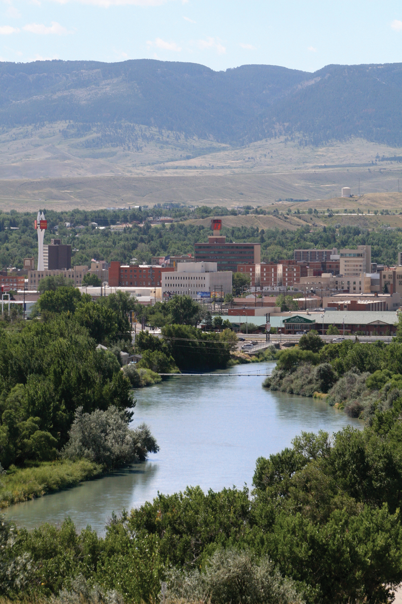


Why visit Casper
Townapedia lists 35 museums and landmarks, 33 parks and trails, 62 places to eat, 26 places to stay and 5 attractions in and around town.
Highlights include Studio City Stadium 10, America Theater, Casper Motor Company-Natrona Motor Company and Consolidated Royalty Building.
July is the warmest month, with average highs of 88°F; January lows average 16°F.
Weather in Casper
Forecast from the National Weather Service. Full forecast
About Casper
Casper is a city in and the county seat of Natrona County, Wyoming, United States. It is the second-most populous city in the state after Cheyenne, with its population at 59,038 as of the 2020 census. Casper is nicknamed "The Oil City" and has a long history of oil boomtown and cowboy culture, dating back to the development of the nearby Salt Creek Oil Field.
From the Wikipedia article Casper, Wyoming (this version), under CC BY-SA 4.0.
Things to do5

Museums and landmarks35

Casper Motor Company-Natrona Motor Company
Monument and historic site · National Register of Historic Places · 0.5 mi
Building in Wyoming, United States of America
Consolidated Royalty Building
Monument and historic site · National Register of Historic Places · 0.5 mi
Building in Wyoming, United States of America

Dean Morgan Junior High School
Monument and historic site · National Register of Historic Places · 0.6 mi
Public primary school in Casper, Wyoming, United States
1440 South Elm Street, Casper

Masonic Temple
Monument and historic site · National Register of Historic Places · 0.6 mi
Building in Casper, Wyoming
Midwest Oil Company Hotel
Monument and historic site · National Register of Historic Places
Hotel building in Wyoming, United States of America
Natrona County High School
Monument and historic site · National Register of Historic Places · 0.4 mi
High school in Wyoming, United States
930 South Elm Street, Casper
Odd Fellows Building
Monument and historic site · National Register of Historic Places · 0.7 mi
Building in Wyoming, United States

Ohio Oil Company Building
Monument and historic site · National Register of Historic Places · 0.6 mi
Office building in Casper, Wyoming

Tribune Building
Monument and historic site · National Register of Historic Places · 0.5 mi
Office building in Casper, Wyoming, United States


Casper Downtown Historic District
Monument and historic site · National Register of Historic Places · 0.5 mi
Historic district in Casper, United States of America
Casper Fire Department Station No. 1
Monument and historic site · National Register of Historic Places · 0.5 mi
Fire station in Casper, Wyoming
Elks Lodge No. 1353
Monument and historic site · National Register of Historic Places
Building in Wyoming, United States of America
23 more on the map.
Parks, trails and playgrounds33


Casper Municipal Golf Course
Golf course · 1.0 mi
2120 Allendale Boulevard, Casper

Cheney Alumni Field
Sports field and stadium · 0.4 mi
725 South Oak Street, Casper
21 more on the map.
Restaurants and cafes62

Firehouse Pizza Wood Fired
Restaurant · Pizza · 3.5 mi
395 Newport Street, Casper
Mo-Sa 11:00-20:00; Su 12:00-20:00


Bayou Bar & Grill
Bar and pub · 2.4 mi
Hometown pub offers a cozy atmosphere with modern hospitality, making it the perfect destination for relaxation and good times with loved ones.
301 Platte Avenue, Mills
Mo-Fr 07:00-02:00, Sa-Su 09:00-02:00
The Snack Shack
Cafe · Snack, Sandwich, Smoothie, Ice Cream, Juice · 1.6 mi
211 South Montana Avenue, Casper
Tu-Fr 11:00-18:00
Butch's Bar
Bar and pub · 2.5 mi
1180 Oildale Street, Evansville
06:00-02:00
La Costa
Restaurant · Mexican · 1.0 mi
Mo-Th 11:00-21:00; Fr-Sa 11:00-22:00; Su 11:00-21:00
Outback Steakhouse
Restaurant · American, Steak · 2.9 mi
229 Miracle Street, Evansville
Mo-Th 11:00-22:00; Fr-Sa 11:00-22:30; Su 11:00-21:00; PH closed
50 more on the map.
History
The city was established east of the former site of Fort Caspar, in an area that grew for European settlers during the mid-19th century mass migration of land seekers along the Oregon, California, and Mormon trails, where several nearby ferries offered passage across the North Platte River in the early 1840s. In 1859, Louis Guinard built a bridge and trading post near the original ferry locations, allowing overland travel to continue through the area.
The government also posted the military garrison to protect telegraph and mail service. It was under the command of Lieutenant Colonel William O. Collins. Native American attacks increased after the Sand Creek Massacre in Colorado in 1864, bringing more troops to the post, which was by now called Platte Bridge Station. In July 1865, Lt. Colonel William Collins' beloved son Lieutenant Caspar W. Collins was killed near the post by a group of Indian warriors, and three months later the garrison was renamed Fort Caspar in his son's honor.
In 1867, the troops were ordered to abandon Fort Caspar in favor of Fort Fetterman, downstream on the North Platte along the Bozeman Trail. However, the town itself was settled twenty years later in 1887, and incorporated a year later by developers as an anticipated stopping point during the expansion of the Wyoming Central Railway.
From the History section of Casper, Wyoming on Wikipedia, under CC BY-SA 4.0.
Where to stay26
Churches and places of worship10
Church of Saint Anthony
Church · National Register of Historic Places
644 South Center Street
Imitate the Image Ministries
Church · Baptist · 1.5 mi
1124 North Elma Street, Casper
Shopping18
Gas and EV charging12
Schools, colleges and libraries43
Healthcare7
Map of Casper
250 places. The map loads OpenStreetMap tiles when you open it.
Climate by month
Monthly table
| Month | High | Low | Rain |
|---|---|---|---|
| Jan | 38°F | 16°F | 0.4 in |
| Feb | 40°F | 18°F | 0.6 in |
| Mar | 49°F | 25°F | 1.0 in |
| Apr | 57°F | 31°F | 1.5 in |
| May | 67°F | 41°F | 2.7 in |
| Jun | 79°F | 50°F | 1.6 in |
| Jul | 88°F | 56°F | 1.2 in |
| Aug | 86°F | 55°F | 1.0 in |
| Sep | 76°F | 44°F | 1.1 in |
| Oct | 61°F | 33°F | 1.2 in |
| Nov | 48°F | 25°F | 0.5 in |
| Dec | 38°F | 17°F | 0.7 in |
U.S. Climate Normals 1991-2020 for Casper Wwtp (2 mi away), NOAA NCEI.
People and cost of living
American Community Survey 5-year estimates, 2020-2024, U.S. Census Bureau. Estimates have margins of error, larger for small towns.
Disaster history
Natrona County has had 7 federal disaster declarations since 2000, most often for fires.
- 2023-09-11: Flooding (Flood)
- 2020-04-11: Covid-19 Pandemic (Biological)
- 2020-03-13: Covid-19 (Biological)
- 2015-10-11: Station Fire (Fire)
- 2012-09-09: Sheep Herder Hill Fire Complex (Fire)
- 2006-08-14: Jackson Canyon Fire (Fire)
OpenFEMA disaster declarations summaries.
Getting there and nearby towns
Casper-Natrona County International Airport (CPR) is the nearest airport with scheduled flights listed in OpenStreetMap, 9 miles away.
- Hartrandt 3 mi northwest, about 5 min by car
- Mills 4 mi west, about 6 min by car
- Evansville 4 mi northeast, about 6 min by car
- Bar Nunn 6 mi north, about 9 min by car
- Vista West 6 mi west, about 10 min by car
- Red Butte 6 mi southwest, about 10 min by car
- Casper Mountain 7 mi south, about 11 min by car
- Glenrock 24 mi east, about 39 min by car
- Rolling Hills 25 mi east, about 39 min by car
- Douglas 47 mi east, about 1 h 15 min by car
Drive times are estimates from straight-line distance, not routes.
Local news
Headlines from INDB, the NEMICO news database.
Reviews, tips and questions
Loading what members have shared...
Sources and licences
- NCES EDGE (Public domain): public schools
- NOAA NCEI U.S. Climate Normals 1991-2020 (Public domain): climate by month
- OpenFEMA (Public domain): disaster declarations
- OpenStreetMap contributors (ODbL 1.0): places, airports, map data
- U.S. Census Bureau (Public domain): population, income, housing, education, commute
- Wikidata (CC0 1.0): elevation, founding date, time zone, website, landmarks and historic places
- Wikimedia Commons (see each image): photos
- Wikipedia (CC BY-SA 4.0): overview and history text
Photo credits
- Casperskyline, Adbay Original uploader was Adbay at en.wikipedia, Public domain
- 100 Block Center St, Casper, Andrew Farkas, CC BY-SA 3.0
- BPOE 1353 in Casper, WY USA, Andrew Farkas, CC BY-SA 3.0
- StAnthonyCasperWY, Jonathunder, GFDL 1.2
- Church of Saint Anthony, Casper, WY USA, Andrew Farkas, CC BY-SA 3.0
- Midwest Oil Company Hotel, Casper, WY, 25or6to4, CC BY-SA 4.0
- St. Anthony's Catholic Church - Casper - Wyoming - Tony Webster, Tony Webster, CC BY 2.0
- Bryant Butler Brooks House, Casper, Wyoming, Drmccreedy, CC BY-SA 4.0
- First State Bank in Casper Wyoming, Tony Webster, CC BY 2.0
- BMO Bank Drive-Thru ATM Machine - Casper Wyoming, Tony Webster, CC BY 2.0
- Garbage Truck Protecting the Casper Holiday Parade Wyoming, Tony Webster, CC BY 2.0
- Natrona County Library in Casper Wyoming, Tony Webster, CC BY 2.0
- Townhomes in Casper Wyoming, Tony Webster, CC BY 2.0
- Casper Police - Wyoming, Tony Webster, CC BY 2.0
- WesternerNewsCasperWY, Jonathunder, GFDL 1.2
- ARS Flood and Fire Cleanup - Casper Holiday Parade - Wyoming, Tony Webster, CC BY 2.0
- Tracked Outdoors Casper Wyoming Holiday Parade, Tony Webster, CC BY 2.0
- Casper Police Officer in the Holiday Parade, Tony Webster, CC BY-SA 2.0
- MingHouseCasperWY, Jonathunder, GFDL 1.2
- Casper Fire Department Station - Wyoming, Tony Webster, CC BY 2.0
- FireDeptStation1CasperWY, Jonathunder, GFDL 1.2
- Casper Fire Department Station No. 1, Athletesrun, CC BY-SA 3.0
- Townsend Hotel Casper Wyoming, Athletesrun, CC BY-SA 3.0
- Jeffree Star The Store - Casper - Wyoming (54269429528), Tony Webster, CC BY 2.0
- GeoSurveyMarkCasperWY, Jonathunder, GFDL 1.2
- First Interstate Bank - Casper - Wyoming (52953605679), Tony Webster, CC BY 2.0
- Consolditated Royalty Building in Casper, WY USA, Andrew Farkas, CC BY-SA 3.0
- Townsend Hotel,Casper WY, Chevsapher, CC0
- Ewing T. Kerr Federal Building - U.S. Courthouse - Casper - Wyoming (52706895543), Tony Webster from United States, CC BY-SA 2.0
- TheLyricCasperWY, Jonathunder, CC BY-SA 4.0
- Casper-Natrona Command Communications Center - Wyoming, Tony Webster, CC BY 2.0
- Federal Courthouse in Casper, WY USA, Andrew Farkas, CC BY-SA 3.0
- Odd Fellows Building, Casper, WY USA, Andrew Farkas, CC BY-SA 3.0
- JrHighCasperWY, Jonathunder, CC BY-SA 4.0
- MasonicTempleCasperWY, Jonathunder, GFDL 1.2
- Ohio Oil Campany Building, Andrew Farkas, CC BY-SA 3.0
- OutletCasperWY, Jonathunder, GFDL 1.2
- Roosevelt High School Casper Wyoming, Athletesrun, CC BY-SA 3.0
- Turner-CottmanBldgCasperWY, Jonathunder, GFDL 1.2
- National Historic Trails Interpretive Center, Henry Tom, CC BY 4.0


Page built October 30, 2026. Spotted a mistake? Tell us or suggest a place.