
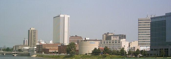


Cedar Rapids, Iowa
Cedar Rapids is a city of 137,264 people in Linn County, Iowa, founded in 1849.
Why visit Cedar Rapids
Townapedia lists 91 museums and landmarks, 91 parks and trails, 227 places to eat, 20 places to stay and 10 attractions in and around town.
Highlights include Paramount Theatre, IANR Railroad Underpass, African American Museum Of Iowa and Cedar Rapids Museum of Art.
July is the warmest month, with average highs of 83°F; January lows average 11°F.
Weather in Cedar Rapids
Forecast from the National Weather Service. Full forecast
About Cedar Rapids
Cedar Rapids is a city in Linn County, Iowa, United States, and the county seat. The population was 137,710 at the 2020 census, and was estimated at 137,935 in 2025. making it the second-most populous city in Iowa. The city lies on both banks of the Cedar River, 20 miles (32 km) north of Iowa City and 128 miles (206 km) northeast of Des Moines, the state's capital.
From the Wikipedia article Cedar Rapids, Iowa (this version), under CC BY-SA 4.0.
Things to do10

Paramount Theatre
Cinema and theater · National Register of Historic Places · 1.1 mi
Theater and movie theater in Cedar Rapids, Iowa, United States
123 3rd Avenue Southeast, Cedar Rapids

IANR Railroad Underpass
Bridge · National Register of Historic Places · 2.6 mi
Bridge in United States of America

Mount Mercy University
School · 3.0 mi
American Catholic liberal arts university

AMC Classic
Cinema and theater · 1.9 mi
2435 Edgewood Road Southwest, Cedar Rapids
closed

McGrath Amphitheatre
Cinema and theater · 0.8 mi
475 1st Street Southwest, Cedar Rapids

Museums and landmarks91

African American Museum Of Iowa
Museum · 1.0 mi
Museum “to preserve, exhibit, and teach the African American heritage of Iowa.” in Cedar Rapids, Iowa
55 12th Avenue Southeast, Cedar Rapids
Tu-Th,Sa 10:00-16:00; Fr 10:00-14:00

Cedar Rapids Museum of Art
Museum · 1.3 mi
410 3rd Avenue Southeast, Cedar Rapids
Tu-Fr,Su 12:00-16:00; Sa 10:00-16:00
National Czech & Slovak Museum & Library
Museum · 0.9 mi
1400 Inspiration Place SW, Cedar Rapids
Mo-Sa 09:30-16:00; Su 12:00-16:00

Brucemore
Monument and historic site · National Register of Historic Places · 2.8 mi
Building in Iowa, United States

C.S.P.S. Hall
Museum · National Register of Historic Places · 1.1 mi
Building in Iowa, United States
1103 3rd Street Southeast, Cedar Rapids


Cedar Rapids Scottish Rite Temple
Museum · National Register of Historic Places · 1.5 mi
Building in Iowa, United States
616 A Avenue Northeast, Cedar Rapids

A. T. Averill House
Monument and historic site · National Register of Historic Places · 1.8 mi
Historic building located in Cedar Rapids, Iowa, United States
Ausadie Building
Monument and historic site · National Register of Historic Places · 1.6 mi
Building in Iowa, United States
B Avenue NE Historic District
Monument and historic site · National Register of Historic Places · 2.5 mi
Historic district in Iowa, United States
Best Oil and Refining Company Service Station
Monument and historic site · National Register of Historic Places · 1.4 mi
Historic building located in Cedar Rapids, Iowa, United States
Bethel African Methodist Church
Monument and historic site · National Register of Historic Places · 1.3 mi
Church building in Cedar Rapids, United States of America
Bever Woods Historic District
Monument and historic site · National Register of Historic Places · 2.7 mi
Historic district in Cedar Rapids, Iowa
79 more on the map.
Parks, trails and playgrounds91

Hanging Bog State Preserve
Park · 6.8 mi
Park in Linn County, Iowa, United States of America


79 more on the map.
Restaurants and cafes227

Texas Roadhouse
Restaurant · Steak House · 2.0 mi
2605 Edgewood Road Southwest
Mo-Th 15:00-22:00; Fr,Sa 11:00-23:00; Su 11:00-22:00

Applebee's
Diner · American · 2.1 mi
2645 Edgewood Road Southwest
Mo-Th 11:00-23:00; Fr,Sa 11:00-24:00; Su 11:00-22:00

CaFé Tacuba
Restaurant · Breakfast, Mexican · 1.2 mi
1006 3rd Street Southeast
Mo-Th 08:30-21:00; Fr-Sa 07:00-22:00; Su 07:00-21:00
Cafe Tacuba
Cafe · Mexican · 1.1 mi
1006 3rd Street Southeast
Mo-Th 09:00-21:00; Fr-Sa 07:00-22:00; Su 07:00-21:00
Carlos O'Kelly's
Restaurant · Mexican · 2.0 mi
2635 Edgewood Road Southwest
Su-Th 11:00-22:00; Fr,Sa 11:00-23:00
China King
Restaurant · Chinese · 2.4 mi
3005 Wiley Boulevard
Tu-Sa 10:30-21:30; Su 11:00-21:30; Mo off
Kismet Coffee & Bloom
Cafe · Coffee Shop · 1.1 mi
1000 3rd Street Southeast, Cedar Rapids
We-Fr 07:00-15:00; Sa,Su 08:00-15:00
215 more on the map.
Where to stay20
DoubleTree by Hilton Hotel Cedar Rapids Convention Complex
Motel and hotel · 1.2 mi
350 1st Avenue East, Cedar Rapids
Churches and places of worship82
Mother Mosque of America
Place of worship · National Register of Historic Places · 1.6 mi
1335 9th Street Northwest, Cedar Rapids
Saint James United Methodist Church
Church · Methodist · 1.6 mi
1430 Ellis Boulevard Northwest, Cedar Rapids
Shopping36
Gas and EV charging28
Casey's General Store
Gas station · 3.2 mi
3349 Mount Vernon Road Southeast, Cedar Rapids
Schools, colleges and libraries66
Healthcare31
Saint Luke's Westside Urgent Care
Clinic and pharmacy · 2.0 mi
2375 Edgewood Road Southwest, Cedar Rapids
UI Urgent Care - Cedar Rapids, 10th Street
Clinic and pharmacy · 1.6 mi
411 10th Street Southeast, Cedar Rapids
Bridgehaven Pregancy Support Center
Clinic and pharmacy · 2.1 mi
701 Center Point Road Northeast, Cedar Rapids
Map of Cedar Rapids
250 places. The map loads OpenStreetMap tiles when you open it.
Climate by month
Monthly table
| Month | High | Low | Rain |
|---|---|---|---|
| Jan | 28°F | 11°F | 0.9 in |
| Feb | 33°F | 16°F | 1.2 in |
| Mar | 46°F | 27°F | 2.0 in |
| Apr | 60°F | 38°F | 3.6 in |
| May | 71°F | 50°F | 4.2 in |
| Jun | 80°F | 60°F | 5.6 in |
| Jul | 83°F | 63°F | 4.4 in |
| Aug | 81°F | 60°F | 4.1 in |
| Sep | 75°F | 52°F | 3.4 in |
| Oct | 62°F | 40°F | 2.9 in |
| Nov | 46°F | 28°F | 2.0 in |
| Dec | 33°F | 17°F | 1.6 in |
U.S. Climate Normals 1991-2020 for Cedar Rapids Muni Ap 72545 (6 mi away), NOAA NCEI.
People and cost of living
American Community Survey 5-year estimates, 2020-2024, U.S. Census Bureau. Estimates have margins of error, larger for small towns.
Disaster history
Linn County has had 12 federal disaster declarations since 2000, most often for severe storms.
- 2020-08-17: Severe Storms (Severe Storm)
- 2020-03-23: Covid-19 Pandemic (Biological)
- 2020-03-13: Covid-19 (Biological)
- 2016-10-31: Severe Storms And Flooding (Flood)
- 2014-08-05: Severe Storms, Tornadoes, Straight-Line Winds, And Flooding (Severe Storm)
- 2013-07-02: Severe Storms, Tornadoes, And Flooding (Severe Storm)
OpenFEMA disaster declarations summaries.
Getting there and nearby towns
Eastern Iowa Airport (CID) is the nearest airport with scheduled flights listed in OpenStreetMap, 6 miles away.
- Fairfax 6 mi southwest, about 9 min by car
- Hiawatha 6 mi north, about 10 min by car
- Marion 7 mi northeast, about 12 min by car
- Ely 7 mi southeast, about 12 min by car
- Robins 8 mi north, about 13 min by car
- Swisher 8 mi south, about 13 min by car
- Shueyville 8 mi south, about 13 min by car
- Atkins 9 mi west, about 15 min by car
- Palo 9 mi northwest, about 15 min by car
- Walford 10 mi southwest, about 16 min by car
Drive times are estimates from straight-line distance, not routes.
Local news
Headlines from INDB, the NEMICO news database.
Reviews, tips and questions
Loading what members have shared...
Sources and licences
- NCES EDGE (Public domain): public schools
- NOAA NCEI U.S. Climate Normals 1991-2020 (Public domain): climate by month
- OpenFEMA (Public domain): disaster declarations
- OpenStreetMap contributors (ODbL 1.0): places, airports, map data
- U.S. Census Bureau (Public domain): population, income, housing, education, commute
- Wikidata (CC0 1.0): elevation, founding date, time zone, website, landmarks and historic places
- Wikimedia Commons (see each image): photos
- Wikipedia (CC BY-SA 4.0): overview and history text
Photo credits
- Cedar Rapids skyline, Iowahwyman, CC BY-SA 3.0
- Greetings from Cedar Rapids, Iowa - Large Letter Postcard (7079657403), Steve Shook from Moscow, Idaho, USA, CC BY 2.0
- Fans @ Cedar Rapids (309868670), Joel Dinda from Mulliken, Michigan, CC BY 2.0
- Anthem, Cedar Rapids (309868251), Joel Dinda from Mulliken, Michigan, CC BY 2.0
- Cedar Rapids from United 793 (6305381158), InSapphoWeTrust from Los Angeles, California, USA, CC BY-SA 2.0
- Cedar Rapids Milk Condensing Company, Jim Roberts, CC BY-SA 4.0
- Dairy Queen, Cedar Rapids, June 12 2008, en:User:Interiority, CC BY-SA 3.0
- Metered Parking and Bike Lane on 3rd Avenue Bridge - Cedar Rapids, Iowa (24961956291), Tony Webster from Minneapolis, Minnesota, United States, CC BY-SA 2.0
- Metered Parking and Bike Lane on 3rd Avenue Bridge - Cedar Rapids, Iowa (24687623329), Tony Webster from Minneapolis, Minnesota, United States, CC BY-SA 2.0
- African American Museum of Iowa, Griot2012, CC BY-SA 3.0
- Mother Mosque of America Cedar Rapids IA pic3, RifeIdeas, CC BY-SA 3.0
- Paramount Theater pic1, RifeIdeas, CC BY-SA 3.0
- C.S.P.S. Hall, Kepper66, CC BY-SA 3.0
- Brucemore, ArtisticAbode, CC BY-SA 3.0
- Consistory Building No 2 Cedar Rapids IA pic1, RifeIdeas, CC BY-SA 3.0
- James W. and Ida G. Bowman House, Jim Roberts, CC BY-SA 4.0
- Dows-Street-Historic-District, ArtisticAbode, CC BY-SA 3.0
- High Water Rock, Cedar River, Downtown Cedar Rapids, IA, ABreiholz, CC BY-SA 3.0
- Armstrong Home Cedar Rapids Iowa, ABreiholz, CC BY-SA 3.0
- Cedar Rapids 2nd St SE Automobile Row Historic District-2, Akaymcd, CC BY-SA 3.0
- Grant Home Cedar Rapids Iowa (Frank Lloyd Wright) NW View, ABreiholz, CC BY-SA 3.0
- Joseph P. Mentzer House in Marion, ABreiholz, CC BY-SA 3.0
- LSPeoplesBankCR1, Carptrash at en.wikipedia, CC BY-SA 3.0
- 7th Ave, Marion, IA, James.Heires, CC BY-SA 4.0
- First Universalist Church of Cedar Rapids IA pic1, RifeIdeas, CC BY-SA 3.0
- Seminole Farm barn - east side, James.Heires, CC BY-SA 4.0
- Marion Carnegie Public Library - Marion Iowa, Ian Poellet, CC BY-SA 3.0
- Cedar Rapids Post Office and Public Building 2, Kepper66, CC BY-SA 3.0
- Cedar Rapids - Roosevelt, Davumaya, CC BY-SA 3.0
- Hose Company No. 4 - Cedar Rapids, Iowa, Kepper66, CC BY-SA 3.0
- Iowa Building, Kepper66, CC BY-SA 3.0
- Cedar Rapids - Mays Island, Davumaya, CC BY-SA 3.0
- Witwer Grocery, Kepper66, CC BY-SA 3.0
- Cedar Rapids Central Fire Station, Cedar Rapids, Iowa, ABreiholz, CC BY-SA 3.0
- Oak Hill Cemetery Historic District, Cedar Rapids, Iowa 01, ABreiholz, CC BY-SA 3.0
- IANR Railroad Underpass Cedar Rapids IA pic2, RifeIdeas, CC BY-SA 3.0
- Iowa State Highway Commission, District 6 Building, Jim Roberts, CC BY-SA 4.0
- Kernels Dugout (309868424), Joel Dinda from Mulliken, Michigan, CC BY 2.0
- The Old Vet (309869059), Joel Dinda from Mulliken, Michigan, CC BY 2.0
- Pitching the Vet (309868787), Joel Dinda from Mulliken, Michigan, CC BY 2.0


Page built October 30, 2026. Spotted a mistake? Tell us or suggest a place.