
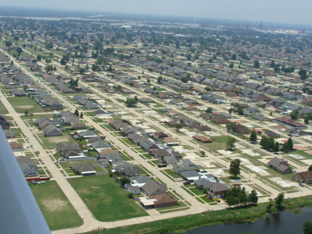


Chalmette, Louisiana
Chalmette is a community of 22,616 people in St. Bernard Parish, Louisiana.
Why visit Chalmette
Townapedia lists 11 museums and landmarks, 7 parks and trails, 11 places to eat, 2 places to stay and 5 attractions in and around town.
Highlights include Chalmette Movies, Claiborne Avenue Bridge, Adolph Meyer School and Friscoville Street Historic District.
August is the warmest month, with average highs of 92°F; January lows average 44°F.
Weather in Chalmette
Forecast from the National Weather Service. Full forecast
About Chalmette
Chalmette is a census-designated place (CDP) in, and the parish seat of, St. Bernard Parish in southeastern Louisiana, United States. The 2010 census reported that Chalmette had 16,751 people; 2011 population was listed as 17,119; however, the pre-Katrina population was 32,069 at the 2000 census. At the 2020 U.S. census, its population rebounded to 21,562. Chalmette is part of the New Orleans–Metairie–Kenner metropolitan statistical area.
From the Wikipedia article Chalmette, Louisiana (this version), under CC BY-SA 4.0.
Things to do5


Claiborne Avenue Bridge
Bridge · 4.0 mi
Bridge in New Orleans, Louisiana

Florida Avenue Bridge
Bridge · 4.2 mi
Vertical lift bridge in New Orleans, Louisiana, United States

St. Claude Avenue Bridge
Bridge · 3.9 mi
Bridge in New Orleans, Louisiana
Museums and landmarks11

Adolph Meyer School
Monument and historic site · National Register of Historic Places · 4.2 mi
United States historic place

Friscoville Street Historic District
Monument and historic site · National Register of Historic Places · 2.1 mi
Historic district in St. Bernard Parish, Louisiana

McDonogh 19 Elementary School
Monument and historic site · National Register of Historic Places · 3.0 mi
School building in New Orleans, United States

U.S. Army Supply Base New Orleans
Monument and historic site · National Register of Historic Places · 4.1 mi
Supply depot in New Orleans, Louisiana


Jackson Barracks
Monument and historic site · National Register of Historic Places · 2.7 mi


Parks, trails and playgrounds7

Brechtel Park
Park · 3.7 mi
Park in Louisiana, United States of America, United States of America
Restaurants and cafes11




Burger King
Fast food · Burger
200 East Judge Perez Drive, Chalmette
Mo-Th 07:00-20:00; Fr-Sa 07:00-21:00; Su 07:00-20:00
Papa John's
Fast food · Pizza
620 West Judge Perez Drive, Chalmette
Mo-Th 10:00-24:00; Fr-Sa 10:00-01:00; Su 10:00-24:00
History
Chalmette was founded by plantation owner Louis-Xavier Martin de Lino de Chalmette (1720–1755), a native of Quebec and grandson of René-Louis Chartier de Lotbinière of Maison Lotbinière. His eldest son, Louis Xavier Martin de Lino de Chalmette (1753–1814) was born there and married the sister of Antoine Philippe de Marigny, grandfather of Bernard de Marigny.
In January 1815, the Battle of New Orleans was fought at the Chalmette plantation, then owned by his second son, Ignace Martin de Lino de Chalmette (1755–1815), a maternal half-brother of Col. Pierre Denis de La Ronde (founder of Versailles, Louisiana), who commanded the Louisiana militia's Third Regiment during the battle. The American forces under Major General Andrew Jackson defeated the British forces (led by brevet Lieutenant General Sir Edward Pakenham). On Andrew Jackson's orders, the Chalmette plantation was completely destroyed during the battle to prevent the British from using it for cover.
The battlefield is preserved as a national monument complete with visitor center, and the Chalmette National Cemetery is adjacent. Since the mid-1970s, the site has been part of the Jean Lafitte National Historical Park and Preserve, a multi-site National Park Service property with its headquarters located in the French Quarter of New Orleans.
From the History section of Chalmette, Louisiana on Wikipedia, under CC BY-SA 4.0.
Where to stay2
Best Western Plus Chalmette Hotel
Motel and hotel · 0.6 mi
3400 Paris Road, Chalmette
Churches and places of worship20
Saint Andrew The Apostle Catholic Church
Church · Roman Catholic · 2.5 mi
3101 Eton Street, New Orleans
Shopping3
Gas and EV charging7
Schools, colleges and libraries50
Alice M Harte Elementary Charter School
School · 2.6 mi
5300 Berkley Dr., New Orleans
Belle Chasse Elementary School
School · 3.6 mi
539 F. Edward Hebert Blvd., Belle Chasse
Belle Chasse Primary School
School · 3.5 mi
601 F. Edward Hebert Blvd., Belle Chasse
Dr. Martin Luther King Charter School For Sci Tech
School · 3.2 mi
1617 Fats Domino Ave., New Orleans
Healthcare4
Map of Chalmette
120 places. The map loads OpenStreetMap tiles when you open it.
Climate by month
Monthly table
| Month | High | Low | Rain |
|---|---|---|---|
| Jan | 62°F | 44°F | 5.8 in |
| Feb | 66°F | 47°F | 4.6 in |
| Mar | 73°F | 53°F | 4.9 in |
| Apr | 79°F | 60°F | 5.3 in |
| May | 87°F | 68°F | 6.3 in |
| Jun | 91°F | 74°F | 8.0 in |
| Jul | 92°F | 76°F | 9.0 in |
| Aug | 92°F | 76°F | 7.4 in |
| Sep | 88°F | 72°F | 5.2 in |
| Oct | 81°F | 64°F | 4.7 in |
| Nov | 72°F | 52°F | 4.3 in |
| Dec | 64°F | 46°F | 4.9 in |
U.S. Climate Normals 1991-2020 for Chalmette (1 mi away), NOAA NCEI.
People and cost of living
American Community Survey 5-year estimates, 2020-2024, U.S. Census Bureau. Estimates have margins of error, larger for small towns.
Disaster history
St. Bernard Parish has had 38 federal disaster declarations since 2000, most often for hurricanes.
- 2026-01-24: Severe Winter Storm (Winter Storm)
- 2024-09-16: Hurricane Francine (Hurricane)
- 2024-09-10: Tropical Storm Francine (Hurricane)
- 2023-09-27: Seawater Intrusion (Other)
- 2021-09-13: Tropical Storm Nicholas (Coastal Storm)
- 2021-08-29: Hurricane Ida (Hurricane)
OpenFEMA disaster declarations summaries.
Getting there and nearby towns
New Orleans Lakefront Airport (NEW) is the nearest airport with scheduled flights listed in OpenStreetMap, 7 miles away.
- Arabi 2 mi west, about 3 min by car
- Meraux 3 mi east, about 5 min by car
- Terrytown 5 mi southwest, about 8 min by car
- Violet 5 mi southeast, about 9 min by car
- Belle Chasse 6 mi south, about 10 min by car
- Gretna 6 mi southwest, about 9 min by car
- New Orleans 8 mi north, about 12 min by car
- Metairie 13 mi west, about 21 min by car
- Bayou Blue 47 mi southwest, about 1 h 15 min by car
- Bayou Cane 52 mi southwest, about 1 h 30 min by car
Drive times are estimates from straight-line distance, not routes.
Local news
Headlines from INDB, the NEMICO news database.
Reviews, tips and questions
Loading what members have shared...
Sources and licences
- NCES EDGE (Public domain): public schools
- NOAA NCEI U.S. Climate Normals 1991-2020 (Public domain): climate by month
- OpenFEMA (Public domain): disaster declarations
- OpenStreetMap contributors (ODbL 1.0): places, airports, map data
- U.S. Census Bureau (Public domain): population, income, housing, education, commute
- Wikidata (CC0 1.0): elevation, founding date, time zone, website, landmarks and historic places
- Wikimedia Commons (see each image): photos
- Wikipedia (CC BY-SA 4.0): overview and history text
Photo credits
- Chalmette, LA, TJM, CC BY 2.0
- Chalmette LA refinery July 2014 - panoramio (1), Mikeiamunion21, CC BY-SA 3.0
- Chalmette LA refinery July 2014 - panoramio (2), Mikeiamunion21, CC BY-SA 3.0
- Chalmette LA refinery July 2014 - panoramio, Mikeiamunion21, CC BY-SA 3.0
- Chalmette, LA, USA - panoramio (2), Aaron Manning, CC BY 3.0
- Chalmette, LA, USA - panoramio (1), Aaron Manning, CC BY 3.0
- Chalmette, LA, USA - panoramio, Aaron Manning, CC BY 3.0
- U.S. Airmen with the 214th Engineering and Installation Squadron, Louisiana National Guard (LANG) distribute water and ice to residents of Chalmette, La., who were affected by Hurricane Isaac Aug...., SPC Tarell J. Bilbo, Public domain
- U.S. Airmen with the 214th Engineering and Installation Squadron, Louisiana National Guard (LANG) distribute water, ice and meals, ready to eat to residents of Chalmette, La., who were affected by..., SPC Tarell J. Bilbo, Public domain
- Chalmette LA refinery July 2014 - panoramio (4), Mikeiamunion21, CC BY-SA 3.0
- Chalmette LA refinery July 2014 - panoramio (3), Mikeiamunion21, CC BY-SA 3.0
- Chalmette LA refinery July 2014 - panoramio (5), Mikeiamunion21, CC BY-SA 3.0
- Boarding the Chalmette-Algiers ferry, Dennis Yang, CC BY 2.0
- Chalmette Algiers Ferry, Louisiana 2015, Dennis Yang, CC BY 2.0
- De La Ronde House Ruins - Chalmette, Louisiana 1985 01, Larry Syverson, CC BY-SA 2.0
- De La Ronde House Ruins - Chalmette, Louisiana 1985 02, Larry Syverson, CC BY-SA 2.0
- NOLA Chalmette Cemetery Trees, Djmaschek, CC BY-SA 4.0
- Chalmette National Cemetary Chalmette LA, NastyCanasta, CC BY-SA 4.0
- Chalmette battlefield monument, Kellyacouch, CC BY-SA 4.0
- Louisiana - Chalmette Battlefield - March 1972, Barbara Spengler, CC BY 2.0
- Chalmette LA Ferry Crossing MS River July 2014 - panoramio (6), Mikeiamunion21, CC BY-SA 3.0
- Chalmette LA Ferry Crossing MS River July 2014 - panoramio (3), Mikeiamunion21, CC BY-SA 3.0
- Chalmette LA Ferry Crossing MS River July 2014 - panoramio (8), Mikeiamunion21, CC BY-SA 3.0
- Chalmette LA Ferry Crossing MS River July 2014 - panoramio (5), Mikeiamunion21, CC BY-SA 3.0
- Battle of New Orleans Site - Chalmette 2022, Mobilus In Mobili, CC BY-SA 2.0
- Chalmette LA Ferry Crossing MS River July 2014 - panoramio (1), Mikeiamunion21, CC BY-SA 3.0
- Chalmette LA Ferry Crossing MS River July 2014 - panoramio (4), Mikeiamunion21, CC BY-SA 3.0
- Chalmette Battlefield Memorial from the River, June 2011, Reading Tom, CC BY 2.0
- Chalmette LA Ferry Crossing MS River July 2014 - panoramio (2), Mikeiamunion21, CC BY-SA 3.0
- Chalmette Battlefield, looking through the cannon, January 2018, The ed17, CC BY-SA 4.0
- AlgiersNOLATubmanElemetarySchool, Infrogmation of New Orleans, CC BY 3.0
- MV Cape Kennedy & MV Cape Knox at the US Army Supply Base in New Orleans 2, Upstateherd, CC BY-SA 3.0
- McDonogh 19 Elementary School (New Orleans, Louisiana), Quentin Melson, CC BY-SA 4.0
- ArabiFriscovilleAug08SchoolB, Infrogmation of New Orleans, CC BY-SA 3.0
- Jackson Barracks October 2011, BrassTacks ( talk ), CC BY-SA 3.0
- ICanalClaiborneBridgeLow9Breach14Dec05, Infrogmation of New Orleans, CC BY 2.5
- FloridaAvenueBridge2Up, Infrogmation, CC BY 2.5
- StClaudeBridgeUpLowSide, Infrogmation, CC BY 2.5
- Greater New Orleans from the Air - St Bernard Parish September 2019 - Paris Road, George Bannister, CC BY 2.0
- Chris Dier, Mm0504, CC BY-SA 4.0


Page built October 30, 2026. Spotted a mistake? Tell us or suggest a place.