
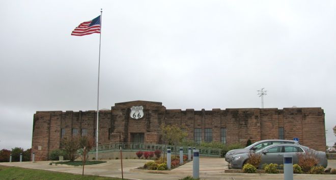


Chandler, Oklahoma
Chandler is a city of 2,899 people in Lincoln County, Oklahoma, founded in 1891.
Why visit Chandler
Townapedia lists 11 museums and landmarks, 1 park or trail, 7 places to eat, 1 place to stay and 1 attraction in and around town.
Highlights include H & S Theatre, Boston Store and Chandler Armory.
July is the warmest month, with average highs of 95°F; January lows average 25°F.
Weather in Chandler
Forecast from the National Weather Service. Full forecast
About Chandler
Chandler (Meskwaki: Chêninêheki) is a city in and the county seat of Lincoln County, Oklahoma, United States. and is part of the Oklahoma City Metropolitan Area. The population was 2,858 at the time of the 2020 census. Chandler is located northeast of Oklahoma City on SH-66 and I-44, north of Shawnee on SH-18 and 14 miles (23 km) south of Agra.
From the Wikipedia article Chandler, Oklahoma (this version), under CC BY-SA 4.0.
Things to do1

Museums and landmarks11

Boston Store
Monument and historic site · National Register of Historic Places · 2.3 mi
Historic two-story building in Chandler, Oklahoma

Chandler Armory
Monument and historic site · National Register of Historic Places · 2.3 mi
Building and museum in Chandler, Oklahoma
Chandler Bookstore
Monument and historic site · National Register of Historic Places · 2.3 mi
Historic building in Chandler, Oklahoma


Clapp-Cunningham Building
Monument and historic site · National Register of Historic Places · 2.4 mi
Historic two-story building in Chandler, Oklahoma
Flynt Building
Monument and historic site · National Register of Historic Places · 2.6 mi
Historic building in Chandler, Oklahoma
Mascho Building and Public Privy
Monument and historic site · National Register of Historic Places · 2.3 mi
Commercial building in Chandler, Oklahoma
St. Cloud Hotel
Monument and historic site · National Register of Historic Places · 2.4 mi
Hotel building in Chandler, Oklahoma

Parks, trails and playgrounds1

Restaurants and cafes7

Destinations
Restaurant · American, German · 2.8 mi
1422 Manvel Avenue, Chandler

McDonald's
Fast food · Burger · 1.0 mi
346480 East 890 Road, Chandler
Su-We 05:00-22:00; Th-Sa 04:00-22:00
Subway
Fast food · Sandwich · 1.4 mi
1804 East 1st Street, Chandler
Tony Wilson DBA Tone's United Nation Pizza
Fast food · 2.0 mi
102 North Oak Avenue, Chandler
Mo-Fr 09:00-17:00
History
Chandler was named after Judge George Chandler, also Assistant Secretary of the Interior. The site of Chandler was opened by a land run on September 28, 1891. The town had been planned to be opened on September 22 (the date of the Land Run of 1891), but the site survey had not been completed. The Chandler Post Office had opened on September 21, the day before the planned run. When Oklahoma Territory County A (Lincoln County) was organized, Chandler became the county seat. On March 30, 1897, a tornado destroyed most of the fledgling town and killed 14 residents.
In 1891, the county government operated from an office building until a courthouse was built. The courthouse was destroyed by the tornado of 1897, and a two-story frame building was erected as a temporary courthouse on the present site. The building was removed in 1907 to make way for a stone courthouse. This third courthouse burned down on December 23, 1967, and the current courthouse was constructed in its place.
On July 31, 1894, Cherokee Bill and the gang he was riding with stole $500 from the Lincoln County Bank in Chandler, Oklahoma.
From the History section of Chandler, Oklahoma on Wikipedia, under CC BY-SA 4.0.
Where to stay1
Churches and places of worship6
First Presbyterian Church of Chandler
Church · National Register of Historic Places · 2.7 mi
St. Stephen's Episcopal Church
Church · National Register of Historic Places · 2.7 mi
Our Lady of Sorrows Catholic Church
Church · Roman Catholic · 2.8 mi
409 South Price Avenue, Chandler
Shopping2
Gas and EV charging2
Schools, colleges and libraries8
Map of Chandler
39 places. The map loads OpenStreetMap tiles when you open it.
Climate by month
Monthly table
| Month | High | Low | Rain | Snow |
|---|---|---|---|---|
| Jan | 52°F | 25°F | 1.2 in | 0.7 in |
| Feb | 57°F | 28°F | 1.5 in | 0.4 in |
| Mar | 66°F | 36°F | 2.8 in | 0.4 in |
| Apr | 74°F | 46°F | 3.7 in | 0.0 in |
| May | 81°F | 56°F | 4.7 in | 0.0 in |
| Jun | 91°F | 66°F | 4.8 in | 0.0 in |
| Jul | 95°F | 70°F | 3.1 in | 0.0 in |
| Aug | 95°F | 68°F | 3.1 in | 0.0 in |
| Sep | 87°F | 60°F | 3.4 in | 0.0 in |
| Oct | 76°F | 48°F | 3.5 in | 0.1 in |
| Nov | 64°F | 36°F | 2.4 in | 0.5 in |
| Dec | 54°F | 27°F | 1.9 in | 0.1 in |
U.S. Climate Normals 1991-2020 for Chandler (2 mi away), NOAA NCEI.
People and cost of living
American Community Survey 5-year estimates, 2020-2024, U.S. Census Bureau. Estimates have margins of error, larger for small towns.
Disaster history
Lincoln County has had 34 federal disaster declarations since 2000, most often for severe storms.
- 2025-05-21: Wildfires And Straight-Line Winds (Fire)
- 2025-03-18: Severe Storms, Straight-Line Winds, Tornadoes, And Flooding (Severe Storm)
- 2025-03-14: Logan Fire (Fire)
- 2025-03-14: Chandler Fire (Fire)
- 2024-04-30: Severe Storms, Straight-Line Winds, Tornadoes, And Flooding (Tornado)
- 2021-02-24: Severe Winter Storms (Severe Ice Storm)
OpenFEMA disaster declarations summaries.
Getting there and nearby towns
Stroud Municipal Airport (SUD) is the nearest airport with scheduled flights listed in OpenStreetMap, 11 miles away.
- Shawnee 26 mi south, about 42 min by car
- Choctaw 29 mi southwest, about 47 min by car
- Edmond 32 mi west, about 52 min by car
- Stillwater 32 mi northwest, about 51 min by car
- Guthrie 34 mi west, about 55 min by car
- Midwest City 35 mi southwest, about 56 min by car
- Del City 39 mi southwest, about 1 h by car
- Oklahoma City 42 mi southwest, about 1 h by car
- Norman 43 mi southwest, about 1 h 15 min by car
- Moore 45 mi southwest, about 1 h 15 min by car
Drive times are estimates from straight-line distance, not routes.
Local news
Headlines from INDB, the NEMICO news database.
Reviews, tips and questions
Loading what members have shared...
Sources and licences
- NCES EDGE (Public domain): public schools
- NOAA NCEI U.S. Climate Normals 1991-2020 (Public domain): climate by month
- OpenFEMA (Public domain): disaster declarations
- OpenStreetMap contributors (ODbL 1.0): places, airports, map data
- U.S. Census Bureau (Public domain): population, income, housing, education, commute
- Wikidata (CC0 1.0): elevation, founding date, time zone, website, landmarks and historic places
- Wikimedia Commons (see each image): photos
- Wikipedia (CC BY-SA 4.0): overview and history text
Photo credits
- Chandler Armory, Skyring, CC BY-SA 3.0
- Chandler, Oklahoma USA - Route 66 Interpretive Center (Chandler Armory 1937) - panoramio (1), MARELBU, CC BY 3.0
- Chandler, Oklahoma USA - Route 66 Interpretive Center (National Register of Historic Places listings in Lincoln County, Oklahoma) - panoramio, MARELBU, CC BY 3.0
- Chandler Johnson House, Taylor Baker, CC BY-SA 3.0
- Chandler, OK USA - panoramio (29), MARELBU, CC BY 3.0
- Chandler, OK USA - Johnson House (National Register of Historic Places ) - panoramio (1), MARELBU, CC BY 3.0
- Chandler, OK USA - Johnson House (National Register of Historic Places ) - panoramio, MARELBU, CC BY 3.0
- Chandler, Oklahoma USA - panoramio (1), MARELBU, CC BY 3.0
- Chandler, OK USA - panoramio (25), MARELBU, CC BY 3.0
- Chandler, Oklahoma USA - Historic Route 66 - panoramio (2), MARELBU, CC BY 3.0
- Chandler, OK USA - panoramio (33), MARELBU, CC BY 3.0
- Chandler, Oklahoma USA - Historic Route 66 - panoramio (cropped), MARELBU, CC BY 3.0
- Chandler, Oklahoma USA - Historic Route 66 - panoramio, MARELBU, CC BY 3.0
- Chandler, Oklahoma USA - Historic Route 66 - panoramio (1), MARELBU, CC BY 3.0
- Chandler, Oklahoma USA - 717 and 719 Manvel (Route 66) - Mascho Building ^ Public Privy (1897 - 1898) - panoramio, MARELBU, CC BY 3.0
- FlyntBldgChandlerOkV2, Melodibit, CC BY-SA 4.0
- MaschoBldgAndPublicPrivyChandlerOk, Melodibit, CC BY-SA 3.0
- ChandlerBookStoreChandlerOk, Melodibit, CC BY-SA 3.0
- Chandler, Oklahoma USA - Phillips 66 Station No. 1423 (b.1930) - National Register of Historic Places - panoramio, MARELBU, CC BY 3.0
- Chandler, OK USA - Crane Motor Company Building (National Register of Historic Places ) - panoramio, MARELBU, CC BY 3.0
- WolcottBldgChandlerOk, Melodibit, CC BY-SA 3.0
- OlesonCraneBldgChandlerOk, Melodibit, CC BY-SA 3.0
- Chandler, Oklahoma USA - panoramio (2), MARELBU, CC BY 3.0
- Chandler, OK USA - panoramio (11), MARELBU, CC BY 3.0
- Chandler, OK USA - panoramio (10), MARELBU, CC BY 3.0
- Chandler, OK USA - panoramio (14), MARELBU, CC BY 3.0
- Chandler, OK USA - panoramio (13), MARELBU, CC BY 3.0
- Chandler, OK USA - panoramio (18), MARELBU, CC BY 3.0
- Chandler, OK USA - panoramio (7), MARELBU, CC BY 3.0
- Chandler, OK USA - panoramio (12), MARELBU, CC BY 3.0
- Chandler, OK High School, Taylor Baker, CC BY-SA 3.0
- Chandler, Oklahoma USA - panoramio, MARELBU, CC BY 3.0
- BostonStoreChandlerOk, Melodibit, CC BY-SA 3.0
- StStephensEpiscopalChurchChandlerOk, Melodibit, CC BY-SA 3.0
- 1st Presbyterian Chandler, Taylor Baker, CC BY-SA 3.0
- ClappCunninghamBldgChandlerOk, Melodibit, CC BY-SA 3.0
- ISS063-E-111808 - View of Earth, Earth Science and Remote Sensing Unit, NASA Johnson Space Center, Public domain
- ISS063-E-111809 - View of Earth, Earth Science and Remote Sensing Unit, NASA Johnson Space Center, Public domain
- ISS063-E-111810 - View of Earth, Earth Science and Remote Sensing Unit, NASA Johnson Space Center, Public domain
- ISS063-E-111807 - View of Earth, Earth Science and Remote Sensing Unit, NASA Johnson Space Center, Public domain


Page built October 30, 2026. Spotted a mistake? Tell us or suggest a place.