


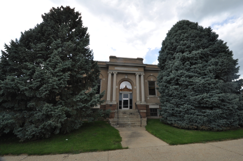


Cherokee, Iowa
Cherokee is a city of 5,154 people in Cherokee County, Iowa, founded in 1873.
Why visit Cherokee
Townapedia lists 11 museums and landmarks, 11 parks and trails, 5 places to eat, 1 place to stay and 1 attraction in and around town.
Highlights include American 3 Fridley Theatres, Cherokee Public Library, Mill Creek Bridge and Cherokee Golf and Country Club.
July is the warmest month, with average highs of 84°F; January lows average 7°F, and about 38 inches of snow fall in a normal year.
Weather in Cherokee
Forecast from the National Weather Service. Full forecast
About Cherokee
Cherokee is a city in and the county seat of Cherokee County, Iowa, United States. The population was 5,199 at the 2020 Census, down from 5,369 in 2000.
From the Wikipedia article Cherokee, Iowa (this version), under CC BY-SA 4.0.
Things to do1

Museums and landmarks11

Cherokee Public Library
Monument and historic site · National Register of Historic Places
Library in Cherokee, Iowa, United States
215 South 2nd Street, Cherokee
Mill Creek Bridge
Monument and historic site · National Register of Historic Places · 2.2 mi
Historic bridge near Cherokee, Iowa, USA
Cherokee Commercial Historic District
Monument and historic site · National Register of Historic Places
Historic district in Cherokee, Iowa
Cherokee Sewer Site
Monument and historic site · National Register of Historic Places · 2.1 mi
Archaic Period Indian archaeological site in Iowa

Guy M. and Rose (Freeman) Gillette House
Monument and historic site · National Register of Historic Places · 0.6 mi
House in Cherokee, Iowa
Illinois Central Railroad Yard-Cherokee
Monument and historic site · National Register of Historic Places
Rail yard in Cherokee, Illinois

Lemuel C. and Mary (Vaughn) Boughton House
Monument and historic site · National Register of Historic Places · 0.4 mi
House in Cherokee, Iowa

Roy C. and Lena (Johnson) Seaman House
Monument and historic site · National Register of Historic Places · 0.5 mi
Historic house in Iowa, United States
Lewis Hotel
Monument and historic site · National Register of Historic Places

Parks, trails and playgrounds11






Restaurants and cafes5


History
Cherokee was laid out as a town in 1870, and was named for the Southeast Indian tribe, most of whose members had been removed to Indian Territory in the late 1830s. Cherokee was incorporated on April 5, 1873.
Tyson Foods closed its Tyson Foods Deli Plant in Cherokee on September 27, 2014. Tyson was the largest employer in Cherokee at the time, and they laid off approximately 450 employees or over eight percent of the total population of Cherokee.
From the History section of Cherokee, Iowa on Wikipedia, under CC BY-SA 4.0.
Where to stay1
Churches and places of worship10
Shopping1
Gas and EV charging1
Schools, colleges and libraries8
Healthcare3
Hy-Vee Clinic Pharmacy
Clinic and pharmacy · 0.8 mi
800 North 2nd Street, Cherokee
Map of Cherokee
52 places. The map loads OpenStreetMap tiles when you open it.
Climate by month
Monthly table
| Month | High | Low | Rain | Snow |
|---|---|---|---|---|
| Jan | 27°F | 7°F | 0.7 in | 7.5 in |
| Feb | 32°F | 11°F | 0.8 in | 8.4 in |
| Mar | 45°F | 23°F | 1.7 in | 5.2 in |
| Apr | 59°F | 34°F | 3.2 in | 2.7 in |
| May | 70°F | 47°F | 4.3 in | 0.1 in |
| Jun | 81°F | 58°F | 5.2 in | 0.0 in |
| Jul | 84°F | 62°F | 3.4 in | 0.0 in |
| Aug | 82°F | 59°F | 4.1 in | 0.0 in |
| Sep | 75°F | 50°F | 3.3 in | 0.0 in |
| Oct | 62°F | 36°F | 2.2 in | 0.5 in |
| Nov | 46°F | 24°F | 1.5 in | 4.0 in |
| Dec | 32°F | 13°F | 0.9 in | 9.4 in |
U.S. Climate Normals 1991-2020 for Cherokee (1 mi away), NOAA NCEI.
People and cost of living
American Community Survey 5-year estimates, 2020-2024, U.S. Census Bureau. Estimates have margins of error, larger for small towns.
Disaster history
Cherokee County has had 17 federal disaster declarations since 2000, most often for severe storms.
- 2024-06-24: Severe Storms, Flooding, Straight-Line Winds, And Tornadoes (Severe Storm)
- 2024-05-24: Severe Storms, Tornadoes, And Flooding (Severe Storm)
- 2022-02-23: Severe Storms, Straight-Line Winds, And Tornadoes (Severe Storm)
- 2020-03-23: Covid-19 Pandemic (Biological)
- 2020-03-13: Covid-19 (Biological)
- 2019-03-23: Severe Storms And Flooding (Flood)
OpenFEMA disaster declarations summaries.
Getting there and nearby towns
Storm Lake Municipal Airport (SLB) is the nearest airport with scheduled flights listed in OpenStreetMap, 19 miles away.
- Alta 14 mi southeast, about 22 min by car
- Storm Lake 20 mi east, about 31 min by car
- Kingsley 24 mi southwest, about 39 min by car
- Primghar 24 mi north, about 38 min by car
- Alton 28 mi northwest, about 46 min by car
- Le Mars 32 mi west, about 51 min by car
- Moville 32 mi southwest, about 51 min by car
- Spencer 34 mi northeast, about 55 min by car
- Sioux City 46 mi west, about 1 h 15 min by car
- South Sioux City 48 mi southwest, about 1 h 15 min by car
Drive times are estimates from straight-line distance, not routes.
Local news
Headlines from INDB, the NEMICO news database.
Reviews, tips and questions
Loading what members have shared...
Sources and licences
- NCES EDGE (Public domain): public schools
- NOAA NCEI U.S. Climate Normals 1991-2020 (Public domain): climate by month
- OpenFEMA (Public domain): disaster declarations
- OpenStreetMap contributors (ODbL 1.0): places, airports, map data
- U.S. Census Bureau (Public domain): population, income, housing, education, commute
- Wikidata (CC0 1.0): elevation, founding date, time zone, website, landmarks and historic places
- Wikimedia Commons (see each image): photos
- Wikipedia (CC BY-SA 4.0): overview and history text
Photo credits
- Cherokee County Courthouse (Iowa), Skye Marthaler, CC BY-SA 3.0
- CherokeeIA LewisHotel, Magicpiano, CC BY-SA 4.0
- Greetings from Cherokee, Iowa - Large Letter Postcard (7893217890), Steve Shook from Moscow, Idaho, USA, CC BY 2.0
- CherokeeIA Library, Magicpiano, CC BY-SA 4.0
- Flickr - jimf0390 - JimF 05-22-10-0001a railroad station at Cherokee, Jim Frost from Sioux City, USA, CC BY 2.0
- Flickr - jimf0390 - JimF 05-22-10-0007a railroad station at Cherokee, Jim Frost from Sioux City, USA, CC BY 2.0
- CherokeeIA CommercialHD 1, Magicpiano, CC BY-SA 4.0
- CherokeeIA CommercialHD 2, Magicpiano, CC BY-SA 4.0
- CherokeeIA IllinoisCentralRRYard, Magicpiano, CC BY-SA 4.0
- Flickr - jimf0390 - JimF 04-11-10-0023a 2 of 3 enjoying sunny afternoon at the park in Cherokee, Jim Frost from Sioux City, USA, CC BY 2.0
- Flickr - jimf0390 - JimF 04-11-10-0021a Canadian-Cherokee geese at the park, Jim Frost from Sioux City, USA, CC BY 2.0
- CherokeeIA MillCreekBridge, Magicpiano, CC BY-SA 4.0
- Seaman House, Cherokee, IA, TheCatalyst31, CC0
- Boughton House, Cherokee, IA, TheCatalyst31, CC0
- Gillette House, Cherokee, IA, TheCatalyst31, CC0
- Flickr - jimf0390 - JimF 05-22-10-0003a baggage handling carts, Jim Frost from Sioux City, USA, CC BY 2.0
- Flickr - jimf0390 - JimF 05-22-10-0005a baggage handling carts, Jim Frost from Sioux City, USA, CC BY 2.0
- Flickr - jimf0390 - JimF 05-22-10-0006a baggage handling carts, Jim Frost from Sioux City, USA, CC BY 2.0
- Flickr - jimf0390 - JimF 04-11-10-0005a yep scooter season has started, Jim Frost from Sioux City, USA, CC BY 2.0
- Flickr - jimf0390 - JimF 04-11-10-0034a looking out to the fountain, Jim Frost from Sioux City, USA, CC BY 2.0
- Flickr - jimf0390 - JimF 04-11-10-0007a pleasant walk around the lake with a friend and yer dog, Jim Frost from Sioux City, USA, CC BY 2.0
- Flickr - jimf0390 - JimF 04-11-10-0025a afternoon at the park, Jim Frost from Sioux City, USA, CC BY 2.0
- Flickr - jimf0390 - JimF 04-11-10-0024b nice afternoon at the park, Jim Frost from Sioux City, USA, CC BY 2.0
- Flickr - jimf0390 - JimF 05-22-10-0020a nice Valkyrie at the park, Jim Frost from Sioux City, USA, CC BY 2.0
- Flickr - jimf0390 - JimF 05-22-10-0018a nice Valkyrie at the park, Jim Frost from Sioux City, USA, CC BY 2.0
- Flickr - jimf0390 - JimF 05-22-10-0017a nice Valkyrie at the park, Jim Frost from Sioux City, USA, CC BY 2.0
- Flickr - jimf0390 - JimF 05-22-10-0019a nice Valkyrie at the park, Jim Frost from Sioux City, USA, CC BY 2.0
- Flickr - jimf0390 - JimF 05-22-10-0021a nice evening for a ride, Jim Frost from Sioux City, USA, CC BY 2.0
- Flickr - jimf0390 - JimF 04-11-10-0027a is the dog gone, Jim Frost from Sioux City, USA, CC BY 2.0
- Flickr - jimf0390 - JimF 06-08-10-0012a pleasant afternoon at the lake, Jim Frost from Sioux City, USA, CC BY 2.0
- Flickr - jimf0390 - JimF 06-08-10-0004a pleasant afternoon at the lake, Jim Frost from Sioux City, USA, CC BY 2.0
- Flickr - jimf0390 - JimF 06-08-10-0003a pleasant afternoon at the lake, Jim Frost from Sioux City, USA, CC BY 2.0
- Flickr - jimf0390 - JimF 06-08-10-0005a pleasant afternoon at the lake, Jim Frost from Sioux City, USA, CC BY 2.0
- Flickr - jimf0390 - JimF 06-08-10-0011a nice walking paths around the lake, Jim Frost from Sioux City, USA, CC BY 2.0
- Flickr - jimf0390 - JimF 06-08-10-0007a shining through, Jim Frost from Sioux City, USA, CC BY 2.0
- Flickr - jimf0390 - JimF 06-08-10-0010a pleasant walk at the lake, Jim Frost from Sioux City, USA, CC BY 2.0
- Flickr - jimf0390 - JimF 04-11-10-0032a geese at the park, Jim Frost from Sioux City, USA, CC BY 2.0
- Air Hoar Frost 2008-02-07, Jim Hammer, CC BY-SA 2.0
- Flickr - jimf0390 - JimF 05-22-10-0041a the Farmall does not go as fast as the Valkyrie, Jim Frost from Sioux City, USA, CC BY 2.0
- Flickr - jimf0390 - JimF 05-22-10-0043a nice display at American Natural Soy, Jim Frost from Sioux City, USA, CC BY 2.0


Page built October 30, 2026. Spotted a mistake? Tell us or suggest a place.