


Chesterton, Indiana
Chesterton is a town of 14,446 people in Porter County, Indiana, founded in 1899.
Why visit Chesterton
Townapedia lists 32 museums and landmarks, 17 parks and trails, 41 places to eat, 5 places to stay and 2 attractions in and around town.
Highlights include Enchanted Forest, 4th Street Theater, Joseph Bailly Homestead and Chesterton Commercial Historic District.
July is the warmest month, with average highs of 82°F; January lows average 18°F, and about 40 inches of snow fall in a normal year.
Weather in Chesterton
Forecast from the National Weather Service. Full forecast
About Chesterton
Chesterton is a town in Westchester, Jackson and Liberty Townships in Porter County, in the U.S. state of Indiana. Its population was 14,242 at the 2020 Census. The three towns of Chesterton, Burns Harbor, and Porter are known as the Duneland area.
From the Wikipedia article Chesterton, Indiana (this version), under CC BY-SA 4.0.
Things to do2

Enchanted Forest
Monument and historic site · 2.4 mi
Water park in Porter, Indiana, United States

Museums and landmarks32

Joseph Bailly Homestead
Monument and historic site · National Register of Historic Places · 2.6 mi
Homestead in Indiana, USA
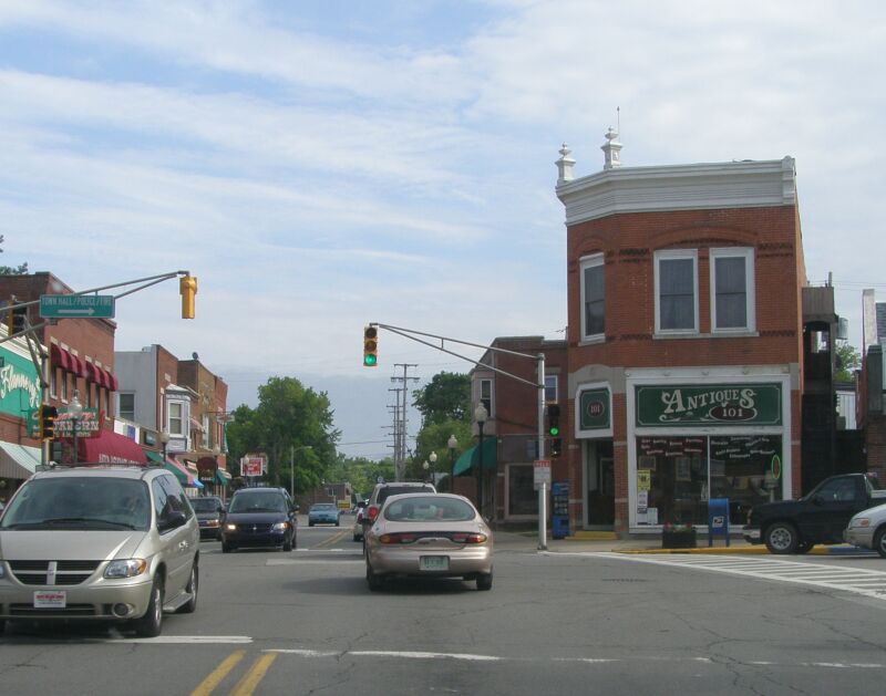
Chesterton Commercial Historic District
Monument and historic site · National Register of Historic Places · 0.8 mi
Chesterton, IN, listed on the NRHP in Indiana

Chesterton Residential Historic District
Monument and historic site · National Register of Historic Places · 0.6 mi
Historic district in Indiana, United States

Dune Acres Clubhouse
Monument and historic site · National Register of Historic Places · 4.0 mi
Building in Indiana, United States of America

George Brown Mansion
Monument and historic site · National Register of Historic Places · 0.5 mi
Building in Indiana, United States

Martin Young House
Monument and historic site · National Register of Historic Places · 0.6 mi
Historic house in Indiana, United States

New York Central Railroad Passenger Depot, Chesterton, Indiana
Monument and historic site · National Register of Historic Places · 0.8 mi
Train station in Chesterton, Indiana
Norris and Harriet Coambs Lustron House
Monument and historic site · National Register of Historic Places · 0.6 mi
Lustron house in Chesterton, Indiana

Read Dunes House
Monument and historic site · National Register of Historic Places · 3.1 mi
Historic house in Indiana, United States

Good Fellow Club Youth Camp
Monument and historic site · National Register of Historic Places · 3.0 mi
Porter Town Hall
Monument and historic site · National Register of Historic Places · 1.4 mi
20 more on the map.
Parks, trails and playgrounds17



_N.JPG)


Indiana Dunes National Park
Park · 4.3 mi
United States National Park in Indiana

Coffee Creek Watershed Preserve
Park · 1.6 mi
A beautiful preserve with clear running water snaking its way through woods. Has an array of trails following the river as it flows.
2401 Village Point, Chesterton

5 more on the map.
Restaurants and cafes41

AJ's Pizza
Restaurant · Pizza · 1.7 mi
3050 Matson Street, Chesterton
Su 11:00-22:00; Mo 15:00-22:00; We-Th 11:00-22:00; Fr-Sa 11:00-23:00
Lucrezia Cafe & Catering
Restaurant · Italian · 0.5 mi
428 South Calumet Road
Mo-Th, Su 11:00-21:00; Fr, Sa 11:00-22:00
Namaste India
Restaurant · Indian · 1.4 mi
715 Plaza Drive, Chesterton
Mo-Th 17:00-22:00; Fr-Su 11:00-14:30, 17:00-22:00

Third Coast Spice Cafe
Restaurant · Regional · 1.5 mi
761 Indian Boundary Road, Chesterton
Mo-Su 06:00-14:00
Val's Famous Pizza & Grinders
Restaurant · Italian · 1.0 mi
112 South 11th Street, Chesterton
Mo-Th 11:00-22:00; Fr, Sa 11:00-23:00; Su 12:00-22:00

Hunter's Brewing
Brewery and winery · 0.4 mi
1535 South Calumet Road, Chesterton
Th 16:00-21:00,Fr-Sa 12:00-21:00,Su 11:00-18:00
Village Tavern
Restaurant · 1.4 mi
128 Lincoln Street, Porter
Mo-Th 10:00-23:00; Fr, Sa 10:00-00:00; Su 11:00-23:00
El Jimador 5
Restaurant · Mexican · 1.4 mi
124 North Lincoln Street, Porter
Mo, Tu, Th, Su 11:00-20:00; Fr, Sa 11:00-21:00
29 more on the map.
History
Chesterton was first settled under the name Coffee Creek in 1833, with its post office being established in 1835. The post office eventually was renamed to Calumet in 1850, as which the town was platted when the railroad was extended to that point in 1852. Due to a town on the same railroad also being named Calumet, the name finally was changed to Chesterton in 1870 and it was reincorporated as a town in 1899 after a failed incorporation in 1869, with its population of 788 being the second-largest in Porter County at the time.
In 1933, a United Airlines NC13304 flight became the first known, proven case of sabotage in an aircraft. It was downed by a nitroglycerine bomb above Chesterton on October 10, 1933. All seven people aboard the aircraft—four passengers and a crew of three—were killed in the crash.
From the History section of Chesterton, Indiana on Wikipedia, under CC BY-SA 4.0.
Where to stay5
Comfort Inn & Suites Porter near Indiana Dunes
Motel and hotel · 2.6 mi
1800 West US Highway 20, Porter
Churches and places of worship12
St. Elizabeth the New Martyr Orthodox Church
Church · Orthodox · 0.7 mi
545 West Indiana Avenue, Chesterton
Bethlehem Lutheran Church
Church · Lutheran · 1.2 mi
2050 West 1100 North, Chesterton
Saint Patrick Church
Church · Roman Catholic · 1.4 mi
638 North Calumet Road, Chesterton
Shopping5
Gas and EV charging7
Schools, colleges and libraries20
Healthcare3
Franciscan Emergency Center Chesterton
Clinic and pharmacy · 1.4 mi
770 Indian Boundary Road, Chesterton
Map of Chesterton
144 places. The map loads OpenStreetMap tiles when you open it.
Climate by month
Monthly table
| Month | High | Low | Rain | Snow |
|---|---|---|---|---|
| Jan | 32°F | 18°F | 2.2 in | 16.0 in |
| Feb | 36°F | 21°F | 2.0 in | 9.7 in |
| Mar | 46°F | 30°F | 2.3 in | 6.0 in |
| Apr | 57°F | 40°F | 3.5 in | 0.6 in |
| May | 68°F | 50°F | 4.3 in | 0.0 in |
| Jun | 78°F | 60°F | 4.3 in | 0.0 in |
| Jul | 82°F | 64°F | 4.0 in | 0.0 in |
| Aug | 80°F | 63°F | 4.1 in | 0.0 in |
| Sep | 74°F | 56°F | 3.6 in | 0.0 in |
| Oct | 62°F | 45°F | 3.8 in | 0.0 in |
| Nov | 49°F | 34°F | 2.8 in | 0.7 in |
| Dec | 37°F | 24°F | 2.3 in | 7.3 in |
U.S. Climate Normals 1991-2020 for Indiana Dunes Nl (3 mi away), NOAA NCEI.
People and cost of living
American Community Survey 5-year estimates, 2020-2024, U.S. Census Bureau. Estimates have margins of error, larger for small towns.
Disaster history
Porter County has had 12 federal disaster declarations since 2000, most often for floods.
- 2026-08-25: Severe Storms, Straight-Line Winds, Tornadoes, And Flooding (Flood)
- 2026-08-15: Severe Storms, Straight-Line Winds, Tornadoes, And Flooding (Flood)
- 2026-01-24: Severe Winter Storm (Winter Storm)
- 2020-04-03: Covid-19 Pandemic (Biological)
- 2020-03-13: Covid-19 (Biological)
- 2018-05-04: Severe Storms And Flooding (Flood)
OpenFEMA disaster declarations summaries.
Getting there and nearby towns
Porter County Regional Airport (VPZ) is the nearest airport with scheduled flights listed in OpenStreetMap, 10 miles away.
- Calumet City 25 mi west, about 40 min by car
- Lansing 25 mi west, about 41 min by car
- Dolton 28 mi west, about 45 min by car
- South Holland 28 mi west, about 46 min by car
- Riverdale 30 mi west, about 49 min by car
- Chicago Heights 31 mi west, about 49 min by car
- Harvey 31 mi west, about 50 min by car
- Homewood 31 mi west, about 51 min by car
- Blue Island 33 mi west, about 52 min by car
- Chicago 36 mi northwest, about 59 min by car
Drive times are estimates from straight-line distance, not routes.
Local news
Headlines from INDB, the NEMICO news database.
Reviews, tips and questions
Loading what members have shared...
Sources and licences
- NCES EDGE (Public domain): public schools
- NOAA NCEI U.S. Climate Normals 1991-2020 (Public domain): climate by month
- OpenFEMA (Public domain): disaster declarations
- OpenStreetMap contributors (ODbL 1.0): places, airports, map data
- U.S. Census Bureau (Public domain): population, income, housing, education, commute
- Wikidata (CC0 1.0): elevation, founding date, time zone, website, landmarks and historic places
- Wikimedia Commons (see each image): photos
- Wikipedia (CC BY-SA 4.0): overview and history text
Photo credits
- Aerial view of Chesterton and Porter, Indiana, October 2024, Pi.1415926535, CC BY-SA 4.0
- State Route 49, Chesterton, Indiana (7993011626), Ken Lund from Reno, Nevada, USA, CC BY-SA 2.0
- Chesterton Middle School - panoramio, hakkun, CC BY-SA 3.0
- Chesterton-Downtown, Chris Light at English Wikipedia, CC BY-SA 3.0
- Main Street Bldg Chesterton IN 2012, GKChest, CC BY-SA 3.0
- Downtown Chesterton - panoramio, hakkun, CC BY-SA 3.0
- Chesterton Bandstand - panoramio, hakkun, CC BY-SA 3.0
- Chesterton, Indiana NYC Passenger Station - June 2017, David Wilson, CC BY 2.0
- 20170605 19 South Shore Cars, Chesterton, Indiana (43288248241), David Wilson from Oak Park, Illinois, USA, CC BY 2.0
- 20170605 20 Chesterton, Indiana (42384420535), David Wilson from Oak Park, Illinois, USA, CC BY 2.0
- Chesterton Water Tower - panoramio, hakkun, CC BY-SA 3.0
- I-94 east at IN 49 - Chesterton, IN - October 2021, AlphaBeta135, CC BY 4.0
- West face 2016-05-21 064, Chris Light, CC BY-SA 4.0
- Chesterton, Indiana NYC Passenger Station, Chris Light ( talk ), CC BY-SA 3.0
- 144 Lincoln P7120019 Queen Anne, c. 1900) N, Chris Light, (Valparaiso, Ind), CC BY-SA 3.0
- Brown Mansion 028, Chris Light ( talk ), CC BY-SA 3.0
- Read Dunes House from road, Nyttend, Public domain
- Chesterton Indiana IOOF Dntwn Hist District P5250016, Chris Light ( talk ), CC BY-SA 3.0
- Dune Acres Clubhouse, Nyttend, Public domain
- 324 Second P7120012 Martin Young Hse ( c. 1880) O, Chris Light ( talk ), CC BY-SA 3.0
- Camp Good Fellow Entrance P6120029, Chris Light, CC BY-SA 4.0
- 2010-11-26 3060x2040 portage indiana dunes, J. Crocker, Attribution
- Mary at St. Patrick's - panoramio, hakkun, CC BY-SA 3.0
- United Methodist Church - panoramio (1), hakkun, CC BY-SA 3.0
- St. John's United Church - panoramio, hakkun, CC BY-SA 3.0
- Norris and Harriet Coambs Lustron House, Jack Boucher, Public domain
- Thomas Memorial Library - panoramio, hakkun, CC BY-SA 3.0
- Calumet Road - panoramio, hakkun, CC BY-SA 3.0
- RR Mem 20-11-05 069, Chris Light, CC BY-SA 4.0
- City as Palimpsest - panoramio, hakkun, CC BY-SA 3.0
- Joe's Towing (50821962252), Ben Schumin from Montgomery Village, Maryland, USA, CC BY-SA 2.0
- Water Tower at Sand Creek Village - panoramio, hakkun, CC BY-SA 3.0
- Amtrak Turboliner 66 in Porter, November 1977, Tim_kd5urs, CC BY-SA 2.0
- Hygrocybe cantharellus 15857406, Django Grootmyers, CC BY-SA 4.0
- I-94 WB at IN 49 (exits 26B-A) - October 2021, AlphaBeta135, CC BY 4.0
- Foggy Coal Train (11222617863), Russell Sekeet, CC BY 2.0
- Bike Trail 1678, Chris Light, CC BY-SA 4.0
- Little Calumet Bridge - panoramio, hakkun, CC BY-SA 3.0
- ISS046-E-39472 - View of Earth, Earth Science and Remote Sensing Unit , Lyndon B. Johnson Space Center, Public domain
- ISS056-E-131129 - View of Earth, Earth Science and Remote Sensing Unit, NASA Johnson Space Center, Public domain


Page built October 30, 2026. Spotted a mistake? Tell us or suggest a place.