
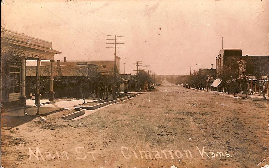


Cimarron, Kansas
Cimarron is a city of 1,949 people in Gray County, Kansas, founded in 1878.
Why visit Cimarron
Townapedia lists 2 museums and landmarks, 5 parks and trails and 1 place to eat in and around town.
Highlights include Cimarron Hotel and Old Gray County Courthouse.
July is the warmest month, with average highs of 93°F; January lows average 18°F.
Weather in Cimarron
Forecast from the National Weather Service. Full forecast
About Cimarron
Cimarron is a city in and the county seat of Gray County, Kansas, United States. As of the 2020 census, the population of the city was 1,981. It is located along Highway 50.
From the Wikipedia article Cimarron, Kansas (this version), under CC BY-SA 4.0.
Museums and landmarks2

Cimarron Hotel
Monument and historic site · National Register of Historic Places
Historic hotel located in Cimarron, a small town located in southwest Kansas, United States


Old Gray County Courthouse
Monument and historic site · National Register of Historic Places · 0.5 mi
Courthouse in Cimarron, Kansas, United States
Parks, trails and playgrounds5



Restaurants and cafes1

Schools, colleges and libraries6

History
Cimarron was first settled in 1878. It took its name from a fork in the Santa Fe Trail which led travelers to the Cimarron River.
Between 1887 and 1893, a county seat war took place in Gray County that involved several notable Old West figures, such as Bat Masterson, Bill Tilghman, and Ben Daniels. As a result of the dispute, Cimarron became the permanent county seat of Gray County.
In the early morning hours of June 10, 1893, Bill Doolin and four members of his gang robbed a train one-half mile east of Cimarron.
In 2016, the Amtrak Southwest Chief was involved in a collision near Cimarron. The train, en route to Chicago from Los Angeles, derailed on a section of track that was damaged by a runaway truck. 28 people were injured in the derailment, which caused over $1.4 million in damage. The tracks were knocked out of alignment the morning before the derailment when a fully loaded truck from Cimarron Crossing Feeders, an adjacent business, ran out of control down a hill leading to the tracks. The truck was removed, but the incident was not reported to local authorities or BNSF, the owner of the tracks.
From the History section of Cimarron, Kansas on Wikipedia, under CC BY-SA 4.0.
Map of Cimarron
14 places. The map loads OpenStreetMap tiles when you open it.
Climate by month
Monthly table
| Month | High | Low | Rain | Snow |
|---|---|---|---|---|
| Jan | 45°F | 18°F | 0.6 in | 3.9 in |
| Feb | 48°F | 21°F | 0.6 in | 3.8 in |
| Mar | 59°F | 30°F | 1.4 in | 3.1 in |
| Apr | 68°F | 39°F | 1.8 in | 0.7 in |
| May | 78°F | 51°F | 2.8 in | 0.1 in |
| Jun | 88°F | 62°F | 3.5 in | 0.0 in |
| Jul | 93°F | 67°F | 3.2 in | 0.0 in |
| Aug | 90°F | 65°F | 3.0 in | 0.0 in |
| Sep | 83°F | 56°F | 1.3 in | 0.0 in |
| Oct | 71°F | 42°F | 1.9 in | 0.5 in |
| Nov | 57°F | 29°F | 0.7 in | 1.4 in |
| Dec | 46°F | 20°F | 0.9 in | 3.8 in |
U.S. Climate Normals 1991-2020 for Cimarron (0 mi away), NOAA NCEI.
People and cost of living
American Community Survey 5-year estimates, 2020-2024, U.S. Census Bureau. Estimates have margins of error, larger for small towns.
Disaster history
Gray County has had 12 federal disaster declarations since 2000, most often for severe storms.
- 2025-05-21: Severe Winter Storm, Straight-Line Winds, Flooding, And Wildfires (Severe Storm)
- 2024-09-24: Severe Storms, Straight-Line Winds, Tornadoes, And Flooding (Severe Storm)
- 2024-04-28: Severe Winter Storm (Winter Storm)
- 2022-05-25: Severe Winter Storms And Straight-Line Winds (Snowstorm)
- 2022-02-17: Severe Storms And Straight Line Winds (Severe Storm)
- 2020-03-29: Covid-19 Pandemic (Biological)
OpenFEMA disaster declarations summaries.
Getting there and nearby towns
Dodge City Regional Airport (DDC) is the nearest airport with scheduled flights listed in OpenStreetMap, 21 miles away.
- Ingalls 6 mi west, about 10 min by car
- Montezuma 16 mi south, about 26 min by car
- Dodge City 18 mi east, about 29 min by car
- Wilroads Gardens 24 mi east, about 38 min by car
- Copeland 24 mi southwest, about 39 min by car
- Jetmore 28 mi northeast, about 45 min by car
- Garden City 30 mi west, about 48 min by car
- Minneola 31 mi southeast, about 51 min by car
- Fowler 31 mi south, about 50 min by car
- Spearville 32 mi east, about 52 min by car
Drive times are estimates from straight-line distance, not routes.
Local news
Headlines from INDB, the NEMICO news database.
Reviews, tips and questions
Loading what members have shared...
Sources and licences
- NCES EDGE (Public domain): public schools
- NOAA NCEI U.S. Climate Normals 1991-2020 (Public domain): climate by month
- OpenFEMA (Public domain): disaster declarations
- OpenStreetMap contributors (ODbL 1.0): places, airports, map data
- U.S. Census Bureau (Public domain): population, income, housing, education, commute
- Wikidata (CC0 1.0): elevation, founding date, time zone, website, landmarks and historic places
- Wikimedia Commons (see each image): photos
- Wikipedia (CC BY-SA 4.0): overview and history text
Photo credits
- Main Street Cimarron Kansas 1914, Unknown (Life time: ), Public domain
- Cimarron Hotel (Cimarron KS) from E 1, Ammodramus, CC0
- Old Gray County Kansas courthouse from NE 1, Ammodramus, CC0
Page built October 30, 2026. Spotted a mistake? Tell us or suggest a place.