


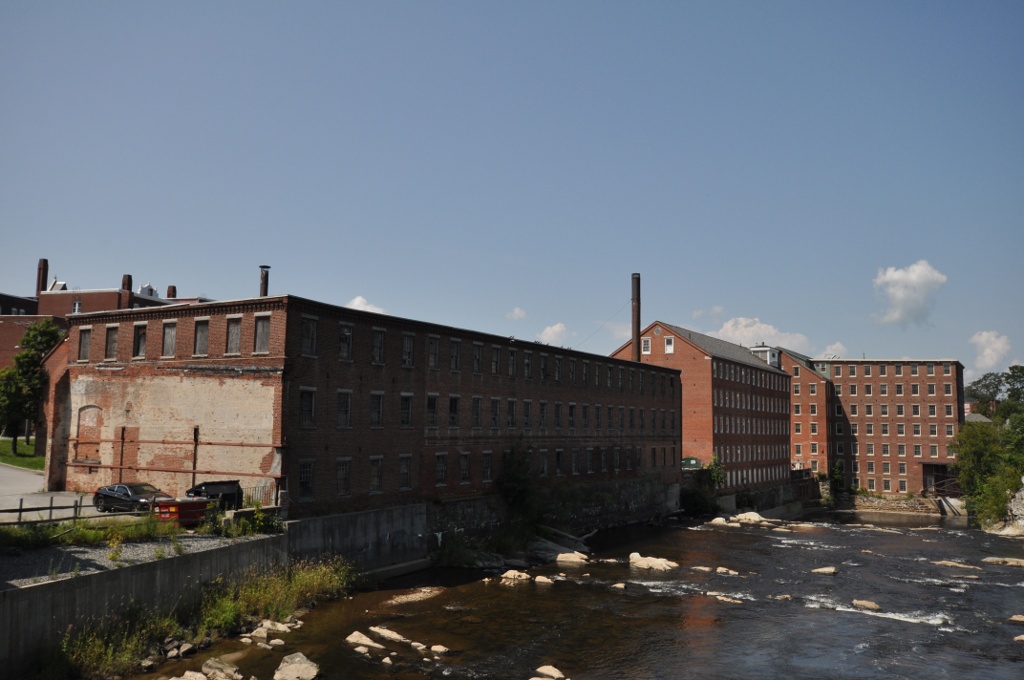

Claremont, New Hampshire
Claremont is a city of 13,078 people in Sullivan County, New Hampshire, founded in 1762.
Why visit Claremont
Townapedia lists 30 museums and landmarks, 29 parks and trails, 31 places to eat, 3 places to stay and 24 attractions in and around town.
Highlights include Arrowhead Recreation Area, Corbin Covered Bridge, American Precision Museum and Ascutney Mill Dam.
July is the warmest month, with average highs of 80°F; January lows average 9°F, and about 66 inches of snow fall in a normal year.
Weather in Claremont
Forecast from the National Weather Service. Full forecast
About Claremont
Claremont is the only city in Sullivan County, New Hampshire, United States. The population was 12,949 at the 2020 census. Claremont is a core city of the Lebanon–Claremont micropolitan area, a bi-state, four-county region in the upper Connecticut River valley.
From the Wikipedia article Claremont, New Hampshire (this version), under CC BY-SA 4.0.
Things to do24

Arrowhead Recreation Area
Ski area · 1.6 mi
Ski area in New Hampshire, United States

Corbin Covered Bridge
Bridge · National Register of Historic Places · 7.0 mi
Covered bridge in New Hampshire, US
Dingleton Hill Covered Bridge
Bridge · National Register of Historic Places · 5.6 mi


12 more on the map.
Museums and landmarks30

American Precision Museum
Museum · National Register of Historic Places · 6.7 mi
United States historic place

Ascutney Mill Dam
Monument and historic site · National Register of Historic Places · 7.0 mi
Dam in Windsor, Vermont
Ascutney State Park
Monument and historic site · National Register of Historic Places · 6.5 mi
State park in Windsor County, Vermont
Central Business District
Monument and historic site · National Register of Historic Places · 1.0 mi
Claremont, New Hampshire historic district
Claremont City Hall
Monument and historic site · National Register of Historic Places · 1.0 mi
City hall of Claremont, New Hampshire, U.S.
Claremont Warehouse No. 34
Monument and historic site · National Register of Historic Places · 0.9 mi
Historic warehouse building at Heritage Drive in Claremont, New Hampshire

Cornish–Windsor Covered Bridge
Bridge · National Register of Historic Places · 6.5 mi
Two-span, timber Town lattice-truss, interstate, covered bridge in New Hampshire and Vermont, United States
David Dexter House
Monument and historic site · National Register of Historic Places · 0.7 mi
Historic house in New Hampshire, United States
Farwell School
Monument and historic site · National Register of Historic Places · 5.9 mi
Charlestown, New Hampshire, listed on the NRHP in Sullivan County, New Hampshire
Lower Village District
Monument and historic site · National Register of Historic Places · 0.9 mi
Historic district in Claremont, New Hampshire
Monadnock Mills
Monument and historic site · National Register of Historic Places · 0.9 mi
Historic mill complex in Claremont, New Hampshire, United States
North Charlestown Historic District
Monument and historic site · National Register of Historic Places · 5.9 mi
Historic district in New Hampshire, United States
18 more on the map.
Parks, trails and playgrounds29





17 more on the map.
Restaurants and cafes31

Kouzoku Japanese Steakhouse
Restaurant · Asian, Grill, Japanese, Noodles, Ramen, Soba, Steak House · 1.3 mi
236 Washington Street
Su 12:00-21:00; Mo, We-Th 11:00-21:00; Fr-Sa 11:00-21:30
Sunshine Cookshop Jamaican Style Restaurant
Restaurant · Jamaican · 1.0 mi
37 Pleasant Street, Claremont
Tu-Fr 11:00-19:00; Sa 11:00-21:00


Tremont House of Pizza
Restaurant · Pizza, Burger, Sandwich, American · 1.3 mi
134 Pleasant Street, Claremont
19 more on the map.
Where to stay3
Churches and places of worship14
Trinity Church
Church · National Register of Historic Places · 6.1 mi
Union Church
Church · Episcopal · 1.9 mi
133 Old Church Road, claremont
Union Episcopal Church
Church · National Register of Historic Places · 1.9 mi
The Church of Jesus Christ of Latter-day Saints
Church · Mormon · 4.0 mi
5431 U.S. Route 5, Ascutney
Shopping11
Gas and EV charging12
Schools, colleges and libraries14
Healthcare2
Map of Claremont
170 places. The map loads OpenStreetMap tiles when you open it.
Climate by month
Monthly table
| Month | High | Low | Rain | Snow |
|---|---|---|---|---|
| Jan | 29°F | 9°F | 2.7 in | 15.2 in |
| Feb | 32°F | 10°F | 2.4 in | 16.7 in |
| Mar | 41°F | 19°F | 3.0 in | 12.7 in |
| Apr | 54°F | 30°F | 3.3 in | 3.3 in |
| May | 66°F | 42°F | 3.3 in | 0.0 in |
| Jun | 75°F | 52°F | 4.2 in | 0.0 in |
| Jul | 80°F | 56°F | 4.2 in | 0.0 in |
| Aug | 79°F | 54°F | 3.8 in | 0.0 in |
| Sep | 71°F | 47°F | 3.5 in | 0.0 in |
| Oct | 58°F | 36°F | 4.9 in | 0.5 in |
| Nov | 46°F | 27°F | 3.2 in | 2.8 in |
| Dec | 35°F | 17°F | 3.5 in | 14.9 in |
U.S. Climate Normals 1991-2020 for Newport (8 mi away), NOAA NCEI.
People and cost of living
American Community Survey 5-year estimates, 2020-2024, U.S. Census Bureau. Estimates have margins of error, larger for small towns.
Disaster history
Sullivan County has had 24 federal disaster declarations since 2000, most often for severe storms.
- 2024-07-10: Severe Winter Storm And Flooding (Winter Storm)
- 2023-09-14: Severe Storms And Flooding (Flood)
- 2021-10-04: Severe Storm And Flooding (Flood)
- 2020-04-03: Covid-19 Pandemic (Biological)
- 2020-03-13: Covid-19 (Biological)
- 2018-01-02: Severe Storm And Flooding (Severe Storm)
OpenFEMA disaster declarations summaries.
Getting there and nearby towns
Claremont Municipal Airport (CNH) is the nearest airport with scheduled flights listed in OpenStreetMap, 2 miles away.
- Ascutney 4 mi northwest, about 6 min by car
- Windsor 7 mi northwest, about 11 min by car
- Newport 8 mi east, about 13 min by car
- Springfield 10 mi southwest, about 16 min by car
- North Springfield 11 mi west, about 17 min by car
- Charlestown 11 mi southwest, about 18 min by car
- Hartland 11 mi north, about 18 min by car
- Concord 40 mi east, about 1 h by car
- Manchester 53 mi southeast, about 1 h 30 min by car
- Greenfield 55 mi south, about 1 h 30 min by car
Drive times are estimates from straight-line distance, not routes.
Local news
Headlines from INDB, the NEMICO news database.
Reviews, tips and questions
Loading what members have shared...
Sources and licences
- NCES EDGE (Public domain): public schools
- NOAA NCEI U.S. Climate Normals 1991-2020 (Public domain): climate by month
- OpenFEMA (Public domain): disaster declarations
- OpenStreetMap contributors (ODbL 1.0): places, airports, map data
- U.S. Census Bureau (Public domain): population, income, housing, education, commute
- Wikidata (CC0 1.0): elevation, founding date, time zone, website, landmarks and historic places
- Wikimedia Commons (see each image): photos
- Wikipedia (CC BY-SA 4.0): overview and history text
Photo credits
- Claremont NH 7-19-26, Ascended Dreamer, CC BY-SA 4.0
- Claremont NH 5-2-26, Ascended Dreamer, CC BY-SA 4.0
- ClaremontNH DavidDexterHouse, Magicpiano, CC BY-SA 3.0
- Claremont NH 5-22-26, Ascended Dreamer, CC BY-SA 4.0
- ClaremontNH MonadnockMills RiverView, Magicpiano, CC BY-SA 3.0
- ClaremontNH MonadnockMills WaterStreet, Magicpiano, CC BY-SA 3.0
- ClaremontNH SullivanCompanyBuildings, Magicpiano, CC BY-SA 3.0
- ClaremontNH SullivanCompanyBuildings2, Magicpiano, CC BY-SA 3.0
- 1950s Mercury sedan The Car Show Claremont Motorsports Park 282 Thrasher Road Claremont NH August 2025 03, Artaxerxes, CC BY 4.0
- 1950s Mercury sedan The Car Show Claremont Motorsports Park 282 Thrasher Road Claremont NH August 2025 04, Artaxerxes, CC BY 4.0
- 1950s Mercury sedan The Car Show Claremont Motorsports Park 282 Thrasher Road Claremont NH August 2025 02, Artaxerxes, CC BY 4.0
- 1950s Mercury sedan The Car Show Claremont Motorsports Park 282 Thrasher Road Claremont NH August 2025 01, Artaxerxes, CC BY 4.0
- ClaremontNH Warehouse34, Magicpiano, CC BY-SA 3.0
- Sullivan Machine Company Office, Claremont, New Hampshire, Doug Kerr from Albany, NY, United States, CC BY-SA 2.0
- Daddypops Tumble Inn Diner door, Claremont, New Hampshire, Kenneth C. Zirkel, CC BY-SA 4.0
- Daddypops Tumble Inn Diner interior, Claremont, New Hampshire, Kenneth C. Zirkel, CC BY-SA 4.0
- Daddypops Tumble Inn Diner, Claremont, New Hampshire after fire, Kenneth C. Zirkel, CC BY-SA 4.0
- Claremont Opera House (City Hall), New Hampshire west facade, Kenneth C. Zirkel, CC BY-SA 4.0
- 1969 Mercury Cyclone CJ 428 The Car Show Claremont Motorsports Park 282 Thrasher Road Claremont NH August 2025 05, Artaxerxes, CC BY 4.0
- 1969 Mercury Cyclone CJ 428 The Car Show Claremont Motorsports Park 282 Thrasher Road Claremont NH August 2025 04, Artaxerxes, CC BY 4.0
- 1969 Mercury Cyclone CJ 428 The Car Show Claremont Motorsports Park 282 Thrasher Road Claremont NH August 2025 02, Artaxerxes, CC BY 4.0
- 1969 Mercury Cyclone CJ 428 The Car Show Claremont Motorsports Park 282 Thrasher Road Claremont NH August 2025 01, Artaxerxes, CC BY 4.0
- 1969 Mercury Cyclone CJ 428 The Car Show Claremont Motorsports Park 282 Thrasher Road Claremont NH August 2025 07, Artaxerxes, CC BY 4.0
- 1969 Mercury Cyclone CJ 428 The Car Show Claremont Motorsports Park 282 Thrasher Road Claremont NH August 2025 06, Artaxerxes, CC BY 4.0
- 1969 Mercury Cyclone CJ 428 The Car Show Claremont Motorsports Park 282 Thrasher Road Claremont NH August 2025 03, Artaxerxes, CC BY 4.0
- Claremont NH Fire Station, Djmaschek, CC BY-SA 4.0
- 1966 Dragon Series 1 roadster The Car Show Claremont Motorsports Park 282 Thrasher Road Claremont NH August 2025 01, Artaxerxes, CC BY 4.0
- 1966 Dragon Series 1 roadster The Car Show Claremont Motorsports Park 282 Thrasher Road Claremont NH August 2025 02, Artaxerxes, CC BY 4.0
- Claremont Opera House (City Hall), New Hampshire, Kenneth C. Zirkel, CC BY-SA 4.0
- Claremont NH Civil War Statue, Djmaschek, CC BY-SA 4.0
- City Hall and Civil War Memorial, Claremont, New Hampshire, Kenneth C. Zirkel, CC BY-SA 4.0
- Claremont NH 32-pdr naval guns, Djmaschek, CC BY-SA 4.0
- Claremont NH Post Office, Djmaschek, CC BY-SA 4.0
- ClaremontNH WilliamRossiterHouse, Magicpiano, CC BY-SA 3.0
- Claremont NH 10-14-25, Ascended Dreamer, CC BY 4.0
- Union Episcopal Church, West Claremont, New Hampshire, Psycateplaidsext, CC BY-SA 3.0
- Main Street, Windsor, VT, Unknown author Unknown author, Public domain
- American Precision Museum Windsor Vermont, Stilfehler, CC BY-SA 3.0
- Cornish-Windsor Covered Bridge - HAER NH-8 - 104661pu, Historic American Engineering Record (HAER), creator, Public domain
- Union Church, West Claremont 1885 engraving, Source: The History: American Episcopal Church 1587-1883 by William Stevens Perry, Vol 1 (1885) page 581, Public domain


Page built October 30, 2026. Spotted a mistake? Tell us or suggest a place.