


Lhasa, China
拉萨市
Lhasa is a regional capital of 867,900 people in Tibet, China, founded in 633.
Why visit Lhasa
Townapedia lists 23 museums and landmarks, 12 parks and trails, 28 places to eat, 45 places to stay and 30 attractions in and around town.
Highlights include Jokhang, Lhasa River Special Bridge, Potala Palace and Karchung Temple.
Weather in Lhasa
Forecast from MET Norway (CC BY 4.0). Full forecast
About Lhasa
Lhasa is the capital and largest city of the Tibet Autonomous Region of China. It is a prefecture-level city that covers an area of 29,274 square kilometres (11,303 sq mi) of rugged and sparsely populated terrain. Its urban center is Lhasa, with around 300,000 residents, which mostly corresponds with the administrative Chengguan District, while its suburbs extend into Doilungdêqên District and Dagzê District. The consolidated prefecture-level city contains an additional five, mostly rural, counties.
From the Wikipedia article Lhasa (prefecture-level city) (this version), under CC BY-SA 4.0.
Travel tips from other travellers: Lhasa on Wikivoyage (CC BY-SA 4.0).
Things to do30
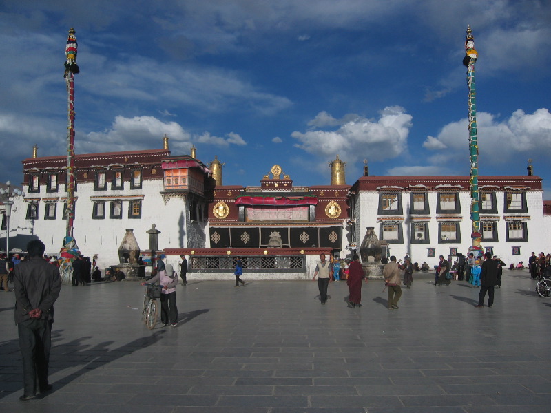
Jokhang
Monument and historic site · 3.1 km
Buddhist temple in Barkhor Square in Lhasa

Lhasa River Special Bridge
Bridge · 7.1 km
Bridge in People's Republic of China


Lhasa Zoo
Zoo and aquarium · 1.2 km
Zoo inside Norbulingka park, originally originally to keep the animals which were given to the Dalai Lamas. (Source: Wikipedia)


18 more on the map.
Museums and landmarks23

Potala Palace
Monument and historic site · 1.8 km
Main residence of former rulers of Tibet.


Monument to the Peaceful Liberation of Tibet
Monument and historic site · 1.7 km
Monument in People's Republic of China

Memorial Hall Marking the Emancipation of More Than One Million Serfs
Museum
Museum in Lhasa, Tibet, China
Tibet Autonomous Region Mass Art Museum
Museum · 2.7 km
Art museum in Lhasa, Tibet, China

Tibet Museum of Natural Science
Museum · 7.8 km
Museum in Lhasa, Tibet, China

Imperial Stele Inscriptions of the Pacification of Tibet
Monument and historic site · 1.9 km


11 more on the map.
Parks, trails and playgrounds12



Restaurants and cafes28

CMGD COFFE
Cafe · Cake, Coffee Shop · 2.2 km
188号 北京西路
Mo-Su 09:00-22:00

Dunya restaurant
Restaurant · Burger, Noodles, Pasta, Curry, Italian Pizza, Local · 3.1 km
100 北京东路
Mo-Su 08:00-10:00, 17:00-23:00
Family Restaurant
Restaurant · Asian · 1.0 km
Norbu Lingka East Street
Mo-Su 07:00-12:00
Mixue Ice Cream & Tea
Cafe · Ice Cream, Bubble Tea · 2.1 km
中国连锁冰淇淋与茶饮品牌,提供高性价比的现制饮品
Mo-Su 09:00-23:00

16 more on the map.
History
Lhasa is the capital and largest city in Tibet. Founded in the 5th century AD and largely closed to foreigners until the early 1980s, its name means "God's Home" or "City of the Gods" and is still very much a pilgrimage destination among Tibetans. After several conflicts of the Mongol invasions and the Qing rule of Tibet, the British led by Francis Younghusband led the expeditions of Tibet. In 1912, the Qing collapse led to Tibet becoming independent on 4 April 1912 with Thubten Gyatso as "the Great Thirteenth" for Tibet's national independence from Qing rule.
The annexation of Tibet by the People's Republic of China took place as Tenzin Gyatso, the 14th Dalai Lama, fled to McLeod Ganj, India in 1959 at the end of the Tibetan uprising.
From the History section of Lhasa (prefecture-level city) on Wikipedia, under CC BY-SA 4.0.
Where to stay45
Churches and places of worship36
Shopping9
Gas and EV charging1
Schools, colleges and libraries50
Healthcare12
Map of Lhasa
246 places. The map loads OpenStreetMap tiles when you open it.
Getting there and nearby towns
Lhasa Gonggar Airport (LXA) is the nearest airport with scheduled flights listed in OpenStreetMap, 43 km away.
- Chéngguān Qū 6 km west, about 6 min by car
- Doilungdêqên 10 km west, about 10 min by car
- Dagzê 24 km east, about 24 min by car
- Lhünzhub 31 km northeast, about 31 min by car
- Quxu 48 km southwest, about 48 min by car
- Dêqên 51 km northwest, about 51 min by car
- Maizhokunggar 64 km east, about 1 h by car
- Lhoka 79 km southeast, about 1 h 15 min by car
Drive times are estimates from straight-line distance, not routes.
Local news
Headlines from INDB.
Reviews, tips and questions
Loading what members have shared...
Sources and licences
- GeoNames (CC BY 4.0): population, coordinates, regions and time zone
- OpenStreetMap contributors (ODbL 1.0): places, airports, map data
- Wikidata (CC0 1.0): elevation, founding date, time zone, website, landmarks and historic places
- Wikimedia Commons (see each image): photos
- Wikipedia (CC BY-SA 4.0): overview and history text
Photo credits
- Lhasa from Potala, Unknown author, CC BY-SA 3.0
- Tibet - Lhasa - 6406875189, Göran Höglund (Kartläsarn), CC BY 2.0
- Tibet - Lhasa - Norbulingka - 6406911599, Göran Höglund (Kartläsarn), CC BY 2.0
- Shuguang DG 1021 pickup, Lhasa, watchsmart from Incheon, cropped by uploader Mr.choppers, CC BY 2.0
- Drepung Monastery. Lhasa, Tibet -5645, Dennis G. Jarvis, CC BY-SA 2.0
- Barkhor Street, Lhasa, Dennis G. Jarvis, CC BY-SA 2.0
- Drepung Monastery. Lhasa, Tibet -5643, Dennis G. Jarvis, CC BY-SA 2.0
- Lhasa, Tibet -5755, Dennis G. Jarvis, CC BY-SA 2.0
- Cooking arear at Drepung Monastery. Lhasa, Tibet -5613, Dennis G. Jarvis, CC BY-SA 2.0
- Drepung Monastery. Lhasa, Tibet -5662, Dennis G. Jarvis, CC BY-SA 2.0
- Qinghai-Tibet Railway Lhasa River Bridge, Pavel Špindler, CC BY-SA 3.0
- 中国西藏拉萨市 China Lhasa Tibet China Xinjiang Urumqi Welcome - panoramio (17), 罗布泊, CC BY 3.0
- Potala, Ondřej Žváček, CC BY 2.5
- 024 - Peaceful Liberation Monument, Jack Versloot, CC BY 2.0
- A European bell and three Tibetan prayer wheels on the summit of Pennabilli, Italy, Goldmund100, CC BY-SA 3.0
- Tibet University Auditorium (2007), en:User:L8rpeace, CC BY 3.0
- Jokhang Temple in Tibet, onwardtibet.org, CC BY-SA 2.0
- TibetanMuseum, Fanghong, CC BY-SA 3.0
- Sera Monastery4, Antoine Taveneaux, CC BY-SA 3.0
- Lhasa-Drepung-32-Klostergebaeude-2014-gje, Gerd Eichmann, CC BY-SA 4.0
- Nechung 20100211 1, drnan tu from Shenzhen, China, CC BY-SA 2.0
- Barkhor street scene, John Hill, CC BY-SA 3.0
- Below Chagpori - 1993 lo-res, John Hill, CC BY 3.0
- Lhasa Zhol Rdo-rings 1993, John Hill at English Wikipedia, CC BY-SA 3.0
- Banak Shöl HotelLhasa, Saipal, CC BY 2.0
- Lhasa Small Mosque, 獅眠洞, CC BY-SA 4.0
- Mosques in Lhasa, Antoine Taveneaux, CC BY-SA 3.0
- Nechung Chok, No machine-readable author provided. John Hill assumed (based on copyright claims)., CC BY 2.5
- Lhasa monument on 19 May 2014, Andrew and Annemarie, CC BY-SA 2.0
- 309Blick auf Chokpori, RThiele, CC BY 3.0
- Tibet - Flickr - Jarvis-24, Dennis G. Jarvis, CC BY-SA 2.0
- Norbulingka on a sunny day, travel oriented, CC BY-SA 2.0
- Drepung monastery, Unknown author, CC BY-SA 3.0
- 1963-03 1963年 拉萨中学学生, 《人民画报》, Public domain
- Tibet, China (236750945), Michael Rehfeldt from Taoyuan, Taiwan, CC BY 2.0
- Tibet, China (235512349), Michael Rehfeldt from Taoyuan, Taiwan, CC BY 2.0
- Tibet, China (236752578), Michael Rehfeldt from Taoyuan, Taiwan, CC BY 2.0
- Tibet, China, Michael Rehfeldt from Taoyuan, Taiwan, CC BY 2.0
- 2007-06-16 Pilgrims, Tibet, watchsmart, CC BY 2.0
- Tibet-5487 (2213121674), Dennis G. Jarvis, CC BY-SA 2.0


Page built November 3, 2026. Spotted a mistake? Tell us or suggest a place.