
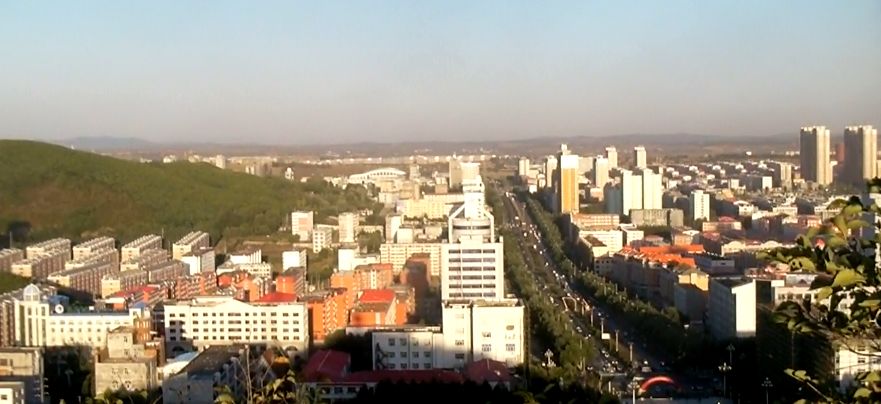


Qitaihe, China
太河村
Qitaihe is a town of 345,033 people in Heilongjiang, China, founded in 1958.
Why visit Qitaihe
Townapedia lists 2 museums and landmarks, 16 parks and trails, 6 places to eat and 7 places to stay in and around town.
Weather in Qitaihe
Forecast from MET Norway (CC BY 4.0). Full forecast
About Qitaihe
Qitaihe (Chinese: 七台河; pinyin: Qītáihé) is a prefecture-level city in eastern Heilongjiang province, China. Covering an area 6,223 km2 (2,403 sq mi), it is geographically the smallest prefecture-level division of the province. Qitaihe also has the second smallest population of the cities in Heilongjiang. At the 2010 census, its total population was 920,419, while 620,935 live in the built up area made of 3 urban districts.
From the Wikipedia article Qitaihe (this version), under CC BY-SA 4.0.
Museums and landmarks2


Parks, trails and playgrounds16



4 more on the map.
Restaurants and cafes6


Where to stay7

History
Qitaihe's history can be stretched back to 3,000 years ago during the Shang and Zhou Dynasties, when it was inhabited by the ancient Sushen group, the ancestors of the Manchu. In 1910, coal resources was found in Qitaihe. However, coal mining industry did not really start until The CPC Committee of Heilongjiang Province ordered Hegang Mining Bureau to take charge of the Extractive industries in Boli County in 1958. Qitaihe began its development. On January 26, 1961, Boli Mining Bureau was established. The CPC Central Committee and State Council approved to establish Qitaihe District (七台河特区) as a pilot of the combination of enterprise management and government administration. In 1970, Qitaihe District was changed into Qitaihe City (county-level), which is under the jurisdiction of Jiamusi. In 1983, Qitaihe was designated a Prefecture-level city, and Boli County was put into Qitaihe's jurisdiction.
From the History section of Qitaihe on Wikipedia, under CC BY-SA 4.0.
Churches and places of worship2
Shopping6
Gas and EV charging11
Schools, colleges and libraries24
Healthcare10
Map of Qitaihe
84 places. The map loads OpenStreetMap tiles when you open it.
Getting there and nearby towns
Jixi Xingkaihu Airport (JXA) is the nearest airport with scheduled flights listed in OpenStreetMap, 55 km away.
- Boli 32 km west, about 32 min by car
- Chengzihe 48 km south, about 48 min by car
- Didao 48 km south, about 48 min by car
- Jixi 53 km south, about 53 min by car
- Jidong 58 km south, about 58 min by car
- Hengshan 63 km south, about 1 h by car
- Huanan 63 km northwest, about 1 h by car
- Heitai 63 km southeast, about 1 h by car
- Mishan 73 km east, about 1 h 15 min by car
- Linkou 78 km southwest, about 1 h 15 min by car
Drive times are estimates from straight-line distance, not routes.
Local news
Headlines from INDB.
Reviews, tips and questions
Loading what members have shared...
Sources and licences
- GeoNames (CC BY 4.0): population, coordinates, regions and time zone
- OpenStreetMap contributors (ODbL 1.0): places, airports, map data
- Wikidata (CC0 1.0): elevation, founding date, time zone, website
- Wikimedia Commons (see each image): photos
- Wikipedia (CC BY-SA 4.0): overview and history text
Photo credits
- Qitaihe Xuefu St, Brian Dell, CC0
- Qitaihe, Heilongjiang WV banner, Brian Dell, CC0
- 步行街 - panoramio (3), 刘贤永, CC BY-SA 3.0
- ISS067-E-159928 - View of Earth, Earth Science and Remote Sensing Unit , Lyndon B. Johnson Space Center, Public domain
- ISS065-E-51090 - View of Earth, Earth Science and Remote Sensing Unit , Lyndon B. Johnson Space Center, Public domain
- ISS067-E-159929 - View of Earth, Earth Science and Remote Sensing Unit , Lyndon B. Johnson Space Center, Public domain
- 电厂大门 - panoramio, 刘贤永, CC BY-SA 3.0
- 大唐电厂 - panoramio, 刘贤永, CC BY-SA 3.0
- ISS045-E-46507 - View of Earth, Earth Science and Remote Sensing Unit , Lyndon B. Johnson Space Center, Public domain
- ISS065-E-51089 - View of Earth, Earth Science and Remote Sensing Unit , Lyndon B. Johnson Space Center, Public domain
- ISS067-E-159926 - View of Earth, Earth Science and Remote Sensing Unit , Lyndon B. Johnson Space Center, Public domain
- ISS067-E-159927 - View of Earth, Earth Science and Remote Sensing Unit , Lyndon B. Johnson Space Center, Public domain
- ISS067-E-159930 - View of Earth, Earth Science and Remote Sensing Unit , Lyndon B. Johnson Space Center, Public domain
- ISS067-E-159931 - View of Earth, Earth Science and Remote Sensing Unit , Lyndon B. Johnson Space Center, Public domain
- ISS047-E-130956 - View of Earth, Earth Science and Remote Sensing Unit , Lyndon B. Johnson Space Center, Public domain
- ISS047-E-130955 - View of Earth, Earth Science and Remote Sensing Unit , Lyndon B. Johnson Space Center, Public domain


Page built November 3, 2026. Spotted a mistake? Tell us or suggest a place.