


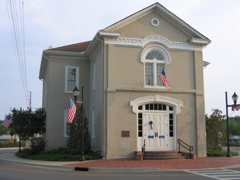


Why visit Columbiana
Townapedia lists 3 museums and landmarks, 4 parks and trails, 11 places to eat and 1 attraction in and around town.
Highlights include Old Shelby County Courthouse and Shelby Iron Company.
July is the warmest month, with average highs of 91°F; January lows average 36°F.
Weather in Columbiana
Forecast from the National Weather Service. Full forecast
About Columbiana
Columbiana is a city and the county seat of Shelby County, Alabama, United States. At the 2020 census, the population was 4,462.
From the Wikipedia article Columbiana, Alabama (this version), under CC BY-SA 4.0.
Things to do1

Museums and landmarks3
Old Shelby County Courthouse
Monument and historic site · National Register of Historic Places · 1.1 mi
Defunct courthouse in Columbiana, Alabama

Shelby Iron Company
Museum · 5.6 mi
Local History Museum in Shelby, AL
Parks, trails and playgrounds4

Columbiana Sports Complex
Park · 1.1 mi
Playgrounds, Batting Cages, Baseball Fields, and a Football/ Soccer Field.


Restaurants and cafes11

Golden City
Restaurant · Chinese · 1.0 mi
113 College, Columbiana
Tu-Su 11:00-22:00


McDonald's
Fast food · Burger · 0.8 mi
301 West College Street, Columbiana
Mo-Th 05:00-23:00; Fr, Sa 05:00-24:00; Su 06:00-23:00
Subway
Fast food · Sandwich · 0.8 mi
305 West College Street, Columbiana
Mo-Th 08:00-21:00; Fr 08:00-22:00; Sa 09:00-22:00; Su 09:00-21:00
History
Columbiana, originally called Columbia, was selected as the county seat of Shelby County in 1826 over rivals Calera and Montevallo. After the selection as the county seat, Columbiana celebrated by drilling holes in a large pine tree and packing it with gunpowder. The tree was blown up and the sound could be heard for miles. Later in 1826, the courthouse was moved to an old school building in Columbiana.
An act of the Alabama Legislature officially changed the name of Shelby County's county seat to Columbiana on January 13, 1832. Columbiana was incorporated on December 5, 1837, with corporate limits one-quarter of a mile in each direction from the public square.
From the History section of Columbiana, Alabama on Wikipedia, under CC BY-SA 4.0.
Churches and places of worship9
Shopping1
Gas and EV charging3
Schools, colleges and libraries10
Map of Columbiana
42 places. The map loads OpenStreetMap tiles when you open it.
Climate by month
Monthly table
| Month | High | Low | Rain |
|---|---|---|---|
| Jan | 56°F | 36°F | 5.3 in |
| Feb | 60°F | 39°F | 5.8 in |
| Mar | 68°F | 46°F | 5.4 in |
| Apr | 75°F | 53°F | 5.1 in |
| May | 82°F | 61°F | 4.2 in |
| Jun | 88°F | 69°F | 4.6 in |
| Jul | 91°F | 72°F | 4.9 in |
| Aug | 91°F | 71°F | 4.7 in |
| Sep | 86°F | 66°F | 3.6 in |
| Oct | 76°F | 54°F | 3.0 in |
| Nov | 66°F | 43°F | 4.6 in |
| Dec | 58°F | 38°F | 5.1 in |
U.S. Climate Normals 1991-2020 for Alabaster Shelby Co Ap 72230 (10 mi away), NOAA NCEI.
People and cost of living
American Community Survey 5-year estimates, 2020-2024, U.S. Census Bureau. Estimates have margins of error, larger for small towns.
Disaster history
Shelby County has had 16 federal disaster declarations since 2000, most often for hurricanes.
- 2024-09-26: Hurricane Helene (Hurricane)
- 2021-12-21: Severe Storms And Flooding (Severe Storm)
- 2021-04-26: Severe Storms, Straight-Line Winds, And Tornadoes (Severe Storm)
- 2020-09-14: Hurricane Sally (Hurricane)
- 2020-03-29: Covid-19 Pandemic (Biological)
- 2020-03-13: Covid-19 (Biological)
OpenFEMA disaster declarations summaries.
Getting there and nearby towns
Birmingham-Shuttlesworth International Airport (BHM) is the nearest airport with scheduled flights listed in OpenStreetMap, 27 miles away.
- Chelsea 8 mi north, about 13 min by car
- Calera 9 mi southwest, about 14 min by car
- Pelham 12 mi northwest, about 19 min by car
- Alabaster 12 mi west, about 19 min by car
- Montevallo 14 mi west, about 23 min by car
- Highland Lakes 14 mi north, about 23 min by car
- Indian Springs Village 14 mi northwest, about 22 min by car
- Harpersville 14 mi northeast, about 23 min by car
- Meadowbrook 15 mi north, about 24 min by car
- Hoover 17 mi northwest, about 27 min by car
Drive times are estimates from straight-line distance, not routes.
Local news
Headlines from INDB, the NEMICO news database.
Reviews, tips and questions
Loading what members have shared...
Sources and licences
- NCES EDGE (Public domain): public schools
- NOAA NCEI U.S. Climate Normals 1991-2020 (Public domain): climate by month
- OpenFEMA (Public domain): disaster declarations
- OpenStreetMap contributors (ODbL 1.0): places, airports, map data
- U.S. Census Bureau (Public domain): population, income, housing, education, commute
- Wikidata (CC0 1.0): elevation, founding date, time zone, website, landmarks and historic places
- Wikimedia Commons (see each image): photos
- Wikipedia (CC BY-SA 4.0): overview and history text
Photo credits
- Columbiana, Alabama City Hall, Rivers Langley; SaveRivers, CC BY-SA 3.0
- Courthouse, Columbiana, Shelby County, Alabama, Farrargirl, CC BY-SA 4.0
- Columbiana, Alabama, Rivers Langley; SaveRivers, CC BY-SA 3.0
- OldShelbyCountyCourthouse, Oakshade at English Wikipedia, CC BY-SA 3.0
- Shelby County, Alabama Courthouse, Rivers Langley; SaveRivers, CC BY-SA 3.0
- ISS031-E-126830 - View of Earth, Earth Science and Remote Sensing Unit , Lyndon B. Johnson Space Center, Public domain
- ISS031-E-126828 - View of Earth, Earth Science and Remote Sensing Unit , Lyndon B. Johnson Space Center, Public domain
- ISS060-E-55215 - View of Earth, Earth Science and Remote Sensing Unit, NASA Johnson Space Center, Public domain
- ISS031-E-126829 - View of Earth, Earth Science and Remote Sensing Unit , Lyndon B. Johnson Space Center, Public domain
- Using a Pressure Canner, Alabama Extension, CC0


Page built October 30, 2026. Spotted a mistake? Tell us or suggest a place.