


Why visit Commerce
Townapedia lists 17 museums and landmarks, 8 parks and trails, 35 places to eat, 3 places to stay and 1 attraction in and around town.
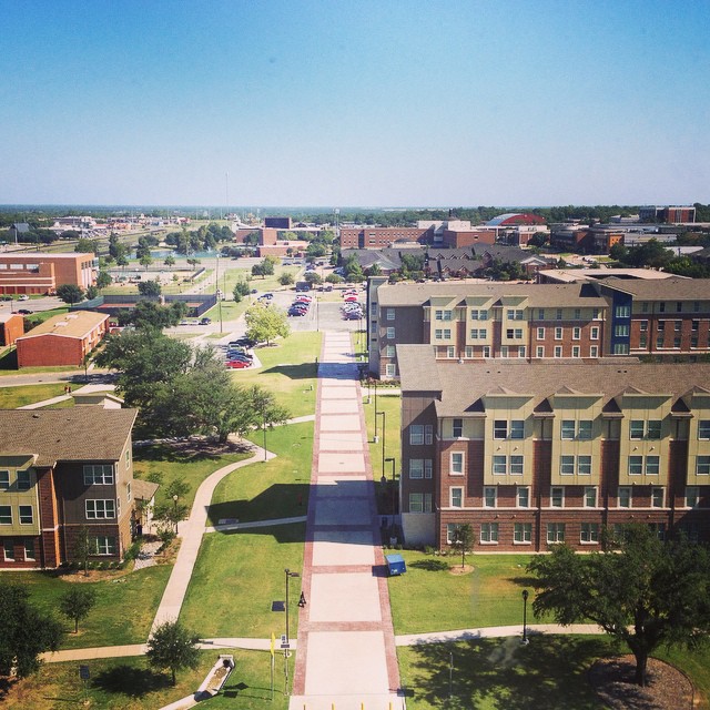
Highlights include East Texas A&M University and Memorial Stadium.
August is the warmest month, with average highs of 98°F; January lows average 33°F.
Weather in Commerce
Forecast from the National Weather Service. Full forecast
About Commerce
Commerce is a city in Hunt County, Texas, United States, situated on the eastern edge of North Texas and the western edge of East Texas, within the Texas Blackland Prairies. Located 45 miles (72 km) south of the Texas/Oklahoma border, Commerce is the second-largest city in Hunt County, Part of the greater Dallas metro area, with a population of 9,090 at the 2020 census. East Texas A&M University, a four-year university of more than 12,000 students, has been in Commerce since 1894. Commerce is one of the smallest college towns in Texas.
From the Wikipedia article Commerce, Texas (this version), under CC BY-SA 4.0.
Things to do1

East Texas A&M University
School · 0.5 mi
University in Commerce, Texas
Museums and landmarks17



5 more on the map.
Parks, trails and playgrounds8

Memorial Stadium
Sports field and stadium · 0.7 mi
1606 State Highway 24, Commerce


Restaurants and cafes35


The Lion's Mane Cafe
Restaurant · 0.5 mi
2200 West Neal Street, Commerce
Mo-Fr 07:00-09:30,Sa-Su 11:00-14:00,17:00-20:00
Los Mochis Mexican Restaurant
Restaurant · Mexican · 0.4 mi
1610 Chestnut Street, Commerce
Luigi's Italian Cafe
Restaurant · Italian · 0.9 mi
1615 State Highway 24, Commerce
Sol Azteca Taqueria y Mas
Restaurant · Mexican · 0.7 mi
1207 Washington Street, Commerce

Texas Cafe Diner Commerce
Diner · American · 0.7 mi
2000 Live Oak Street, Commerce
23 more on the map.
History
Commerce was formed when two merchants named William Jernigan and Josiah Jackson established a trading post and mercantile store where the present-day downtown area is. The rural area just to the northeast was an open prairie originally known as Cow Hill. The town was established in 1872 and named "Commerce" due to the thriving economic activity among the cotton fields and ideal farm and ranch lands between the Middle and South Sulphur rivers on the rich, black gumbo prairie in northeast Hunt County. The town incorporated in 1885. Two years later, a railroad was built through Commerce to transport merchandise from Fort Worth, and nine years later, William L. Mayo, a college educator, moved East Texas Normal College from the northeast Texas town of Cooper to Commerce after the original school in Cooper was destroyed in a fire. Mayo continued as president of the college, now known as East Texas A&M University, until his death in 1917 and is buried on the campus grounds.
From the History section of Commerce, Texas on Wikipedia, under CC BY-SA 4.0.
Where to stay3
Lion's Den Extended Stay
Motel and hotel · 1.4 mi
3000 State Highway 24, Commerce
Churches and places of worship14
Saint Joseph Catholic Church
Church · Roman Catholic
2207 Monroe Street, Commerce
Bread of Life Church of the Nazarene
Church · Nazarene · 1.2 mi
301 East State Highway 224, Commerce
Commerce Church of Christ
Church · Church Of Christ · 0.6 mi
1900 Culver Street, Commerce
First Presbyterian Church
Church · Presbyterian · 0.5 mi
1101 Sycamore Street, Commerce
First United Methodist Church
Church · United Methodist · 0.8 mi
1709 State Highway 24, Commerce
Kingdom Hall of Jehovah’s Witnesses
Church · Jehovahs Witness · 1.4 mi
2050 Wolfe City Drive, Commerce
Shopping4
East Texas A&M University Bookstore
Shop · 0.5 mi
2200 West Neal Street, Commerce
Fix & Feed Commerce Hardware
Hardware store · 0.4 mi
2550 Mangum Street, Commerce
Gas and EV charging7
Schools, colleges and libraries12
Healthcare2
Hunt Regional Emergency Medical Center at Commerce
Clinic and pharmacy · 0.9 mi
2800 State Highway 24, Commerce
Map of Commerce
103 places. The map loads OpenStreetMap tiles when you open it.
Climate by month
Monthly table
| Month | High | Low | Rain | Snow |
|---|---|---|---|---|
| Jan | 58°F | 33°F | 3.2 in | 0.0 in |
| Feb | 62°F | 37°F | 3.5 in | 0.1 in |
| Mar | 69°F | 44°F | 4.4 in | 0.0 in |
| Apr | 77°F | 52°F | 4.1 in | 0.0 in |
| May | 85°F | 62°F | 5.8 in | 0.0 in |
| Jun | 93°F | 70°F | 4.2 in | 0.0 in |
| Jul | 97°F | 74°F | 3.1 in | 0.0 in |
| Aug | 98°F | 73°F | 2.4 in | 0.0 in |
| Sep | 91°F | 66°F | 3.8 in | 0.0 in |
| Oct | 81°F | 54°F | 5.0 in | 0.0 in |
| Nov | 68°F | 43°F | 3.6 in | 0.0 in |
| Dec | 60°F | 36°F | 4.0 in | 0.0 in |
U.S. Climate Normals 1991-2020 for Greenville Kgvl Radio Hcn (13 mi away), NOAA NCEI.
People and cost of living
American Community Survey 5-year estimates, 2020-2024, U.S. Census Bureau. Estimates have margins of error, larger for small towns.
Disaster history
Hunt County has had 14 federal disaster declarations since 2000, most often for hurricanes.
- 2021-02-19: Severe Winter Storms (Severe Ice Storm)
- 2021-02-14: Severe Winter Storm (Severe Ice Storm)
- 2020-03-25: Covid-19 Pandemic (Biological)
- 2020-03-13: Covid-19 (Biological)
- 2011-09-09: Wildfires (Fire)
- 2008-09-10: Hurricane Ike (Hurricane)
OpenFEMA disaster declarations summaries.
Getting there and nearby towns
Majors Airport (GVT) is the nearest airport with scheduled flights listed in OpenStreetMap, 16 miles away.
- Wolfe City 13 mi northwest, about 21 min by car
- Greenville 15 mi southwest, about 24 min by car
- Cooper 15 mi northeast, about 24 min by car
- Celeste 17 mi west, about 28 min by car
- Sulphur Springs 19 mi southeast, about 31 min by car
- Leonard 22 mi northwest, about 36 min by car
- Caddo Mills 23 mi southwest, about 38 min by car
- Honey Grove 24 mi north, about 39 min by car
- West Tawakoni 25 mi south, about 40 min by car
- Farmersville 27 mi west, about 44 min by car
Drive times are estimates from straight-line distance, not routes.
Local news
Headlines from INDB, the NEMICO news database.
Reviews, tips and questions
Loading what members have shared...
Sources and licences
- NCES EDGE (Public domain): public schools
- NOAA NCEI U.S. Climate Normals 1991-2020 (Public domain): climate by month
- OpenFEMA (Public domain): disaster declarations
- OpenStreetMap contributors (ODbL 1.0): places, airports, map data
- U.S. Census Bureau (Public domain): population, income, housing, education, commute
- Wikidata (CC0 1.0): elevation, founding date, time zone, website, landmarks and historic places
- Wikimedia Commons (see each image): photos
- Wikipedia (CC BY-SA 4.0): overview and history text
Photo credits
- A&M-Commerce view., Fkbowen, CC BY-SA 4.0
- Samrayburnstudentcenter, Discontenthearts, CC BY-SA 3.0
- Commerce Post Office, Commerce, Texas Historical Marker (8577797311), Nicolas Henderson from Coppell, Texas, CC BY 2.0
- Jernigins Store, Commerce, Texas Historical Marker (8575769275), Nicolas Henderson from Coppell, Texas, CC BY 2.0
- American Legion Post No. 1, Commerce, Texas Historical Marker (8575769011), Nicolas Henderson from Coppell, Texas, CC BY 2.0
- Incorporation of Commerce, Commerce, Texas Historical Marker (8581005655), Nicolas Henderson from Coppell, Texas, CC BY 2.0
Page built October 30, 2026. Spotted a mistake? Tell us or suggest a place.