


Cresaptown, Maryland
Cresaptown is a community of 5,121 people in Allegany County, Maryland.
Why visit Cresaptown
Townapedia lists 3 museums and landmarks, 3 parks and trails and 4 places to eat in and around town.
Highlights include Barton Village Site and La Vale Tollgate House.
July is the warmest month, with average highs of 87°F; January lows average 22°F, and about 29 inches of snow fall in a normal year.
Weather in Cresaptown
Forecast from the National Weather Service. Full forecast
About Cresaptown
Cresaptown is an unincorporated community and census-designated place (CDP) located in Allegany County, Maryland, United States. As of the 2010 census it had a population of 6,247. Prior to 2010 it was part of the Cresaptown-Bel Air CDP. Cresaptown's post office was established December 22, 1800.
From the Wikipedia article Cresaptown, Maryland (this version), under CC BY-SA 4.0.
Museums and landmarks3

Barton Village Site
Monument and historic site · National Register of Historic Places · 2.3 mi
Archaeological site in Allegany County, United States of America
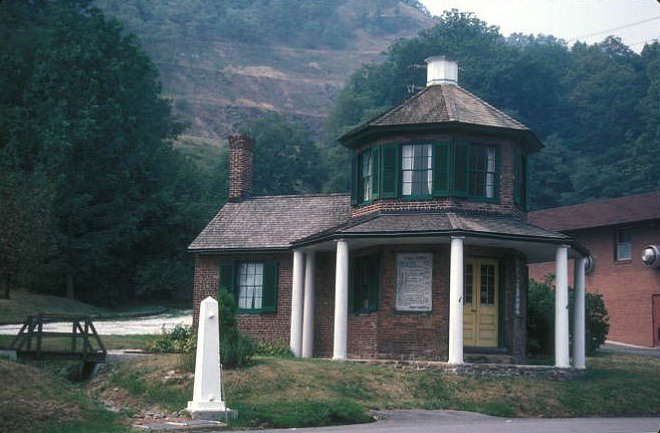
La Vale Tollgate House
Monument and historic site · National Register of Historic Places · 3.2 mi
Building in Allegany County, Maryland, United States


Stewart's Tavern
Monument and historic site · National Register of Historic Places · 3.6 mi
Parks, trails and playgrounds3

Restaurants and cafes4



Churches and places of worship3

History
Prior to 1728, Cresaptown was the site of a Shawnee village along the Potomac River. The inhabitants of this region were a portion of the Shawanese tribe, a sub-division of the Algonquian group. The warriors engaged in hunting and fishing for food and furs, while their families were left at home to tend the maize and grass that grew in the rich soil of the Potomac valley. The maize was ground into corn meal and made into Shawnee cake, a popular diet of the Shawnees living in the valley.
The Shawanees in the valley lived in shelters composed of two forked posts that were driven into the ground, and on these was laid a ridge pole. Small saplings, cut to a length of about 8 feet (2.4 m), were laid against the pole, one end resting on the ground, forming a shelter similar to a V-shaped tent. This was covered with bark and skins and made tight enough to protect against rain or snow. The floors were spread with furs, which made sure for seats or beds.
Emanuel Custer, father of George Armstrong Custer, was born in Cresaptown 1806, and moved to Ohio in 1845, finally settling in Michigan.
From the History section of Cresaptown, Maryland on Wikipedia, under CC BY-SA 4.0.
Shopping1
Gas and EV charging3
Schools, colleges and libraries20
Center For Career & Technical Education
School · 0.7 mi
14211 Mcmullen Hwy Sw, Cresaptown
Healthcare1
Map of Cresaptown
38 places. The map loads OpenStreetMap tiles when you open it.
Climate by month
Monthly table
| Month | High | Low | Rain | Snow |
|---|---|---|---|---|
| Jan | 39°F | 22°F | 2.8 in | 8.2 in |
| Feb | 43°F | 24°F | 2.4 in | 7.7 in |
| Mar | 53°F | 31°F | 3.4 in | 6.8 in |
| Apr | 66°F | 41°F | 3.4 in | 0.1 in |
| May | 75°F | 51°F | 4.2 in | 0.0 in |
| Jun | 82°F | 60°F | 3.9 in | 0.0 in |
| Jul | 87°F | 64°F | 3.7 in | 0.0 in |
| Aug | 85°F | 63°F | 3.4 in | 0.0 in |
| Sep | 78°F | 55°F | 3.5 in | 0.0 in |
| Oct | 67°F | 43°F | 2.8 in | 0.0 in |
| Nov | 54°F | 34°F | 2.6 in | 0.5 in |
| Dec | 43°F | 27°F | 3.0 in | 5.4 in |
U.S. Climate Normals 1991-2020 for Cumberland 2 Hcn (5 mi away), NOAA NCEI.
People and cost of living
American Community Survey 5-year estimates, 2020-2024, U.S. Census Bureau. Estimates have margins of error, larger for small towns.
Disaster history
Allegany County has had 11 federal disaster declarations since 2000, most often for hurricanes.
- 2026-01-24: Severe Winter Storm (Winter Storm)
- 2020-03-26: Covid-19 Pandemic (Biological)
- 2020-03-13: Covid-19 (Biological)
- 2016-03-04: Severe Winter Storm And Snowstorm (Snowstorm)
- 2012-11-20: Hurricane Sandy (Hurricane)
- 2012-10-28: Hurricane Sandy (Hurricane)
OpenFEMA disaster declarations summaries.
Getting there and nearby towns
Greater Cumberland Regional Airport (CBE) is the nearest airport with scheduled flights listed in OpenStreetMap, 4 miles away.
- Bel Air 1 mi southwest, about 2 min by car
- Potomac Park 2 mi northeast, about 3 min by car
- Bowling Green 3 mi northeast, about 5 min by car
- Carpendale 3 mi northeast, about 5 min by car
- Cumberland 6 mi northeast, about 9 min by car
- Bowmans Addition 8 mi northeast, about 12 min by car
- Winchester 46 mi southeast, about 1 h 15 min by car
- Martinsburg 47 mi east, about 1 h 15 min by car
- Johnstown 51 mi north, about 1 h 15 min by car
- Cheat Lake 54 mi west, about 1 h 30 min by car
Drive times are estimates from straight-line distance, not routes.
Local news
Headlines from INDB, the NEMICO news database.
Reviews, tips and questions
Loading what members have shared...
Sources and licences
- NCES EDGE (Public domain): public schools
- NOAA NCEI U.S. Climate Normals 1991-2020 (Public domain): climate by month
- OpenFEMA (Public domain): disaster declarations
- OpenStreetMap contributors (ODbL 1.0): places, airports, map data
- U.S. Census Bureau (Public domain): population, income, housing, education, commute
- Wikidata (CC0 1.0): elevation, founding date, time zone, website, landmarks and historic places
- Wikimedia Commons (see each image): photos
- Wikipedia (CC BY-SA 4.0): overview and history text
Photo credits
- 2016-05-05 15 14 05 View north along Maryland State Route 53 (Winchester Road) in Cresaptown, Allegany County, Maryland, Famartin, CC BY-SA 4.0
- 2016-06-18 16 42 41 View north along U.S. Route 220 (McMullen Highway) at Maryland State Route 53 (Winchester Road) in Cresaptown, Allegany County, Maryland, Famartin, CC BY-SA 4.0
- 7, Cresaptown-Bel Air, MD 21502, USA - panoramio - Idawriter (1), Idawriter, CC BY-SA 3.0
- 2020-05-28 15 43 10 View east along Maryland State Route 636 (Warrior Drive) at Maryland State Route 53 (Winchester Road) in Cresaptown, Allegany County, Maryland, Famartin, CC BY-SA 4.0
- 2020-05-28 15 37 59 View west along Maryland State Route 636 (Warrior Drive) at U.S. Route 220 (McMullen Highway) in Cresaptown, Allegany County, Maryland, Famartin, CC BY-SA 4.0
- 2016-05-05 15 11 23 View west along Maryland State Route 636 (Warrior Drive) at U.S. Route 220 (McMullen Highway) in Cresaptown, Allegany County, Maryland, Famartin, CC BY-SA 4.0
- 7, Cresaptown-Bel Air, MD 21502, USA - panoramio - Idawriter, Idawriter, CC BY-SA 3.0
- 7, Cresaptown-Bel Air, MD 21502, USA - panoramio, Idawriter, CC BY-SA 3.0
- 2017-06-02 10 39 58 View north along Maryland State Route 951 (Old Cresaptown Road) at Oleander Drive just north of Cresaptown in Allegany County, Maryland, Famartin, CC BY-SA 4.0
- 2017-06-02 10 39 14 View south along Maryland State Route 951 (Old Cresaptown Road) at Vine Street just north of Cresaptown in Allegany County, Maryland, Famartin, CC BY-SA 4.0
- LA VALE TOLLGATE HOUSE, JERRYE & ROY KLOTZ MD, CC BY-SA 3.0
- Stewarts Tavern, Generic1139, CC BY-SA 3.0
- 2016-05-05 15 25 04 View south along McMullen Highway (U.S. Route 220) in Bel Air, Allegany County, Maryland, Famartin, CC BY-SA 4.0


Page built October 30, 2026. Spotted a mistake? Tell us or suggest a place.