




Why visit Crosby
Townapedia lists 9 museums and landmarks, 2 parks and trails, 4 places to eat, 4 places to stay and 1 attraction in and around town.
Highlights include Ironton City Hall and Crosby station.
July is the warmest month, with average highs of 82°F; January lows average 0°F.
Weather in Crosby
Forecast from the National Weather Service. Full forecast
About Crosby
Crosby is a city in Crow Wing County, Minnesota, United States. The population was 2,360 at the 2020 census. It is part of the Brainerd Micropolitan Statistical Area. Crosby is adjacent to its twin city of Ironton, in the Cuyuna Iron Range.
From the Wikipedia article Crosby, Minnesota (this version), under CC BY-SA 4.0.
Things to do1

Museums and landmarks9

Ironton City Hall
Monument and historic site · National Register of Historic Places · 1.8 mi
Fire station in Ironton, United States of America

Crosby station
Monument and historic site · National Register of Historic Places · 0.7 mi
Former Soo Line depot in Minnesota, USA
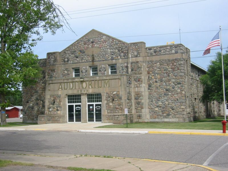
Deerwood Auditorium
Monument and historic site · National Register of Historic Places · 2.5 mi
Community center in Deerwood, Minnesota, United States
Milford Mine
Monument and historic site · National Register of Historic Places · 3.1 mi
Building in Minnesota, United States of America

Spina Hotel
Monument and historic site · National Register of Historic Places · 1.8 mi
Hotel in Ironton, United States of America

Cuyuna Iron Range Municipally-Owned Elevated Metal Water Tanks
Monument and historic site · National Register of Historic Places · 0.7 mi


Ironton Sintering Plant Complex
Monument and historic site · National Register of Historic Places · 1.4 mi

Parks, trails and playgrounds2

Crosby Memorial Park
Park · 1.1 mi
Park setting. Swing set, great playground equipment, beach, boat launch, ball fields, picnic area.
3rd Avenue Southwest, Crosby
Restaurants and cafes4

Red Raven Bike Cafe
Restaurant · Coffee Shop, Tea, Alcohol, Beer, Dessert, Panini, Soup · 1.0 mi
2 3rd Avenue Northwest, Crosby
Tu closed, Mo,We-Sa 09:00-19:00, Su 09:00-16:00

Cuyuna Brewing;Cuyuna Brewing Company
Bar and pub · 0.8 mi
1 East Main Street, Crosby

History
Crosby was built for the sole purpose of mining. It was named for George H. Crosby, a businessman in the mining industry.
Crosby was the location of Minnesota's worst mining disaster, the Milford Mine disaster. On February 5, 1924, a new tunnel was blasted too close to nearby Foley Lake, and water rushed in, killing 41 miners.
In the 1932 local elections, Karl Emil Nygard was elected president of Crosby's Village Council, making it the first city in the United States to have a Communist mayor. 27-year-old Nygard won by a vote of 529 - 359, with goals to raise money for families on welfare, declare a moratorium on government debts to local banks, and guarantee water and electricity services to all citizens.
Once Nygard was elected in 1933, he and village workers rallied for the First National Bank of Crosby to release $23,000 in village funds which it was withholding, which it did, allowing the government to feed unemployed citizens. In January 1933, Nygard also organized an "Unemployed Council," who subsequently demanded relief stipends, free city water and lights, freedom to purchase food from any store, and the abolition of the "Relief Administration" where citizens had to ask the council for financial assistance. The council agreed to all demands except the last. Nygard's and council members' salaries were reduced, as were those of the Crosby police force.
From the History section of Crosby, Minnesota on Wikipedia, under CC BY-SA 4.0.
Where to stay4
Shopping2
Gas and EV charging1
Schools, colleges and libraries5
Healthcare1
Map of Crosby
29 places. The map loads OpenStreetMap tiles when you open it.
Climate by month
Monthly table
| Month | High | Low | Rain |
|---|---|---|---|
| Jan | 21°F | 0°F | 0.5 in |
| Feb | 27°F | 4°F | 0.4 in |
| Mar | 40°F | 18°F | 1.0 in |
| Apr | 54°F | 30°F | 1.6 in |
| May | 68°F | 43°F | 3.3 in |
| Jun | 77°F | 53°F | 4.0 in |
| Jul | 82°F | 58°F | 4.3 in |
| Aug | 79°F | 55°F | 3.1 in |
| Sep | 70°F | 47°F | 2.6 in |
| Oct | 56°F | 35°F | 2.4 in |
| Nov | 40°F | 22°F | 0.9 in |
| Dec | 26°F | 8°F | 0.6 in |
U.S. Climate Normals 1991-2020 for Brainerd Crow Wing Co Ap (11 mi away), NOAA NCEI.
People and cost of living
American Community Survey 5-year estimates, 2020-2024, U.S. Census Bureau. Estimates have margins of error, larger for small towns.
Disaster history
Crow Wing County has had 7 federal disaster declarations since 2000, most often for severe storms.
- 2022-08-09: Severe Storms, Straight-Line Winds, Tornadoes, And Flooding (Severe Storm)
- 2020-04-07: Covid-19 Pandemic (Biological)
- 2020-03-13: Covid-19 (Biological)
- 2012-07-06: Severe Storms And Flooding (Severe Storm)
- 2005-09-13: Hurricane Katrina Evacuation (Hurricane)
- 2002-06-01: Mn - By-Pass Fire - 05/31/2002 (Fire)
OpenFEMA disaster declarations summaries.
Getting there and nearby towns
Brainerd Lakes Regional Airport (BRD) is the nearest airport with scheduled flights listed in OpenStreetMap, 11 miles away.
- Ironton 3 mi west, about 5 min by car
- Deerwood 3 mi southeast, about 5 min by car
- Aitkin 12 mi east, about 19 min by car
- Brainerd 15 mi southwest, about 25 min by car
- Breezy Point 15 mi northwest, about 24 min by car
- Crosslake 15 mi northwest, about 24 min by car
- Nisswa 17 mi west, about 27 min by car
- Baxter 19 mi southwest, about 30 min by car
- Cohasset 53 mi north, about 1 h 30 min by car
- Grand Rapids 55 mi north, about 1 h 30 min by car
Drive times are estimates from straight-line distance, not routes.
Local news
Headlines from INDB, the NEMICO news database.
Reviews, tips and questions
Loading what members have shared...
Sources and licences
- NCES EDGE (Public domain): public schools
- NOAA NCEI U.S. Climate Normals 1991-2020 (Public domain): climate by month
- OpenFEMA (Public domain): disaster declarations
- OpenStreetMap contributors (ODbL 1.0): places, airports, map data
- U.S. Census Bureau (Public domain): population, income, housing, education, commute
- Wikidata (CC0 1.0): elevation, founding date, time zone, website, landmarks and historic places
- Wikimedia Commons (see each image): photos
- Wikipedia (CC BY-SA 4.0): overview and history text
Photo credits
- Crosby Depot, McGhiever, CC BY-SA 4.0
- Ironton City Hall-3, Elkman, CC BY-SA 3.0
- Deerwood Auditorium, Todd Murray, CC BY-SA 3.0
- Spina Hotel, McGhiever, CC BY-SA 4.0
- Milford Mine Memorial Park, McGhiever, CC BY-SA 3.0
- Ironton Sintering Plant Complex 02, McGhiever, CC BY-SA 4.0
- CuyunaRangeWaterTanks, Todd Murray, CC BY-SA 3.0
Page built October 30, 2026. Spotted a mistake? Tell us or suggest a place.