
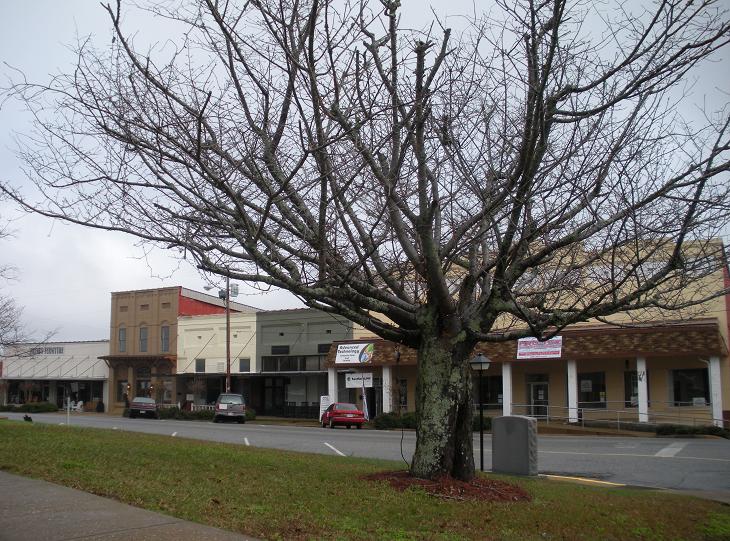


Why visit Dadeville
Townapedia lists 1 museum or landmark and 2 places to eat in and around town.
Highlights include Dadeville Historic District.
July is the warmest month, with average highs of 91°F; January lows average 28°F.
Weather in Dadeville
Forecast from the National Weather Service. Full forecast
About Dadeville
Dadeville is a city in and the county seat of Tallapoosa County, Alabama, United States. At the 2020 census, the population was 3,084, down from 3,230 in 2000.
From the Wikipedia article Dadeville, Alabama (this version), under CC BY-SA 4.0.
Museums and landmarks1

Dadeville Historic District
Monument and historic site · National Register of Historic Places · 0.8 mi
Historic district in Dadeville, Alabama
Restaurants and cafes2

Churches and places of worship9

First Presbyterian Church of Dadeville
Church · 1.0 mi
171 Okefuske Street, Dadeville
Shopping1

History
Prior to its incorporation, Dadeville was an Indian trading post and a center of commerce where commodities such as cotton, lumber, tin, asbestos, and livestock were traded. The town was surveyed by John H. Broadnax in 1836, granted a charter in 1837, and first incorporated in 1858. Dadeville was named for Major Francis Langhorne Dade, who was killed in 1835 by Seminole Indians in a battle of the Second Seminole War that came to be known as the "Dade Massacre". Dade had never actually visited Tallapoosa County.
As a stagecoach stop on the Tennessee Road between Montgomery and Georgia, Dadeville was host to a stream of traders whose goods and livestock often crowded the square of the courthouse. Dadeville lost its charter during the Civil War, and was incorporated a second time in 1878. Dadeville has been the Tallapoosa County seat since 1838.
Dadeville was home to the Graefenberg Medical Institute, Alabama's first medical school, which operated from 1852 until the outbreak of the Civil War. Attempts to revive the school after the war failed, and the building burned in 1873.
The completion of the Martin Dam on the Tallapoosa River in 1926 and the subsequent creation of Lake Martin had and continues to have a strong economic impact on Dadeville.
On April 15, 2023, four people were killed and 32 others were injured in a mass shooting at a party. Most of the victims were teenagers.
From the History section of Dadeville, Alabama on Wikipedia, under CC BY-SA 4.0.
Schools, colleges and libraries5
Horseshoe Bend Regional Library
Library · 0.7 mi
207 North West Street, Dadeville
Healthcare1
Map of Dadeville
19 places. The map loads OpenStreetMap tiles when you open it.
Climate by month
Monthly table
| Month | High | Low | Rain |
|---|---|---|---|
| Jan | 57°F | 28°F | 5.1 in |
| Feb | 61°F | 32°F | 5.2 in |
| Mar | 68°F | 38°F | 5.2 in |
| Apr | 76°F | 45°F | 4.4 in |
| May | 83°F | 55°F | 4.3 in |
| Jun | 89°F | 62°F | 4.8 in |
| Jul | 91°F | 67°F | 4.6 in |
| Aug | 90°F | 63°F | 4.2 in |
| Sep | 86°F | 60°F | 3.1 in |
| Oct | 77°F | 47°F | 3.3 in |
| Nov | 67°F | 37°F | 3.7 in |
| Dec | 58°F | 32°F | 5.1 in |
U.S. Climate Normals 1991-2020 for Camp Hill 2Nw (7 mi away), rain and snow from Dadeville 2, NOAA NCEI.
People and cost of living
American Community Survey 5-year estimates, 2020-2024, U.S. Census Bureau. Estimates have margins of error, larger for small towns.
Disaster history
Tallapoosa County has had 15 federal disaster declarations since 2000, most often for hurricanes.
- 2024-09-26: Hurricane Helene (Hurricane)
- 2023-05-05: Severe Storms, Straight-Line Winds, And Tornadoes (Severe Storm)
- 2023-01-15: Severe Storms, Straight-Line Winds, And Tornadoes (Severe Storm)
- 2020-09-14: Hurricane Sally (Hurricane)
- 2020-07-10: Severe Storms, Straight-Line Winds, And Tornadoes (Severe Storm)
- 2020-03-29: Covid-19 Pandemic (Biological)
OpenFEMA disaster declarations summaries.
Getting there and nearby towns
Thomas C. Russell Field (ALX) is the nearest airport with scheduled flights listed in OpenStreetMap, 12 miles away.
- Alexander City 11 mi northwest, about 18 min by car
- Auburn 22 mi southeast, about 36 min by car
- Opelika 26 mi southeast, about 41 min by car
- Ashland 31 mi north, about 50 min by car
- Blue Ridge 33 mi southwest, about 53 min by car
- Valley 35 mi east, about 56 min by car
- Sylacauga 38 mi northwest, about 1 h by car
- Millbrook 41 mi southwest, about 1 h by car
- Montgomery 44 mi southwest, about 1 h 15 min by car
- LaGrange 45 mi east, about 1 h 15 min by car
Drive times are estimates from straight-line distance, not routes.
Local news
Headlines from INDB, the NEMICO news database.
Reviews, tips and questions
Loading what members have shared...
Sources and licences
- NOAA NCEI U.S. Climate Normals 1991-2020 (Public domain): climate by month
- OpenFEMA (Public domain): disaster declarations
- OpenStreetMap contributors (ODbL 1.0): places, airports, map data
- U.S. Census Bureau (Public domain): population, income, housing, education, commute
- Wikidata (CC0 1.0): elevation, founding date, time zone, website, landmarks and historic places
- Wikimedia Commons (see each image): photos
- Wikipedia (CC BY-SA 4.0): overview and history text
Photo credits
- Dadeville Alabama, Rivers Langley ( phoenixrivers.blogspot.com ), Public domain
- Dadeville Memorial Garden, MrsHoldridge, CC BY 4.0
- Memorial Garden Dedication Dadeville Mass Shooting, MrsHoldridge, CC BY 4.0
- Dadeville Strong, MrsHoldridge, CC BY 4.0
- Dadeville Alabama Miller Hotel, MrsHoldR, CC BY 4.0
- Masonic Building Dadeville, MrsHoldridge, CC BY 4.0
- Commercial Building 115, April Holdridge, CC BY-SA 4.0
- Commercial Building, April Holdridge, CC BY-SA 4.0
- 129 W Columbus Street, MrsHoldridge, CC BY 4.0
- Tallapoosa County Bank, April Holdridge, CC BY-SA 4.0
- Downtown Buildings, MrsHoldR, CC BY 4.0
- Miller Hotel Today, MrsHoldR, CC BY-SA 4.0


Page built October 30, 2026. Spotted a mistake? Tell us or suggest a place.