


Why visit Dayton
Townapedia lists 23 museums and landmarks, 15 parks and trails, 12 places to eat, 1 place to stay and 5 attractions in and around town.
Highlights include Emma Peak, Mount Grosh, C.J. Prescott House and Chollar Mansion.
July is the warmest month, with average highs of 84°F; December lows average 26°F, and about 46 inches of snow fall in a normal year.
Weather in Dayton
Forecast from the National Weather Service. Full forecast
About Dayton
Dayton is an unincorporated community and census-designated place (CDP) in Lyon County, Nevada, United States. The population was 15,153 at the 2020 census. Dayton is the second-oldest Nevada settlement, after Genoa, and is home to the oldest hotel in the state.
From the Wikipedia article Dayton, Nevada (this version), under CC BY-SA 4.0.
Things to do5

Museums and landmarks23

C.J. Prescott House
Monument and historic site · National Register of Historic Places · 6.0 mi
Historic house in Nevada, United States

Chollar Mansion
Monument and historic site · National Register of Historic Places · 6.1 mi
Building in Nevada, United States

Henry Piper House
Monument and historic site · National Register of Historic Places · 6.3 mi
Historic building in Nevada, US

King-McBride Mansion
Monument and historic site · National Register of Historic Places · 6.3 mi
Building in Nevada, United States

McCarthy House
Monument and historic site · National Register of Historic Places · 6.1 mi
NRHP-listed in Storey County

Parish House
Monument and historic site · National Register of Historic Places · 6.0 mi
Historic house in Nevada, United States

Piper-Beebe House
Monument and historic site · National Register of Historic Places · 6.2 mi
Historic house in Nevada, United States

Piper's Opera House
Cinema and theater · National Register of Historic Places · 6.3 mi
Theatre in Virginia City, Nevada, United States
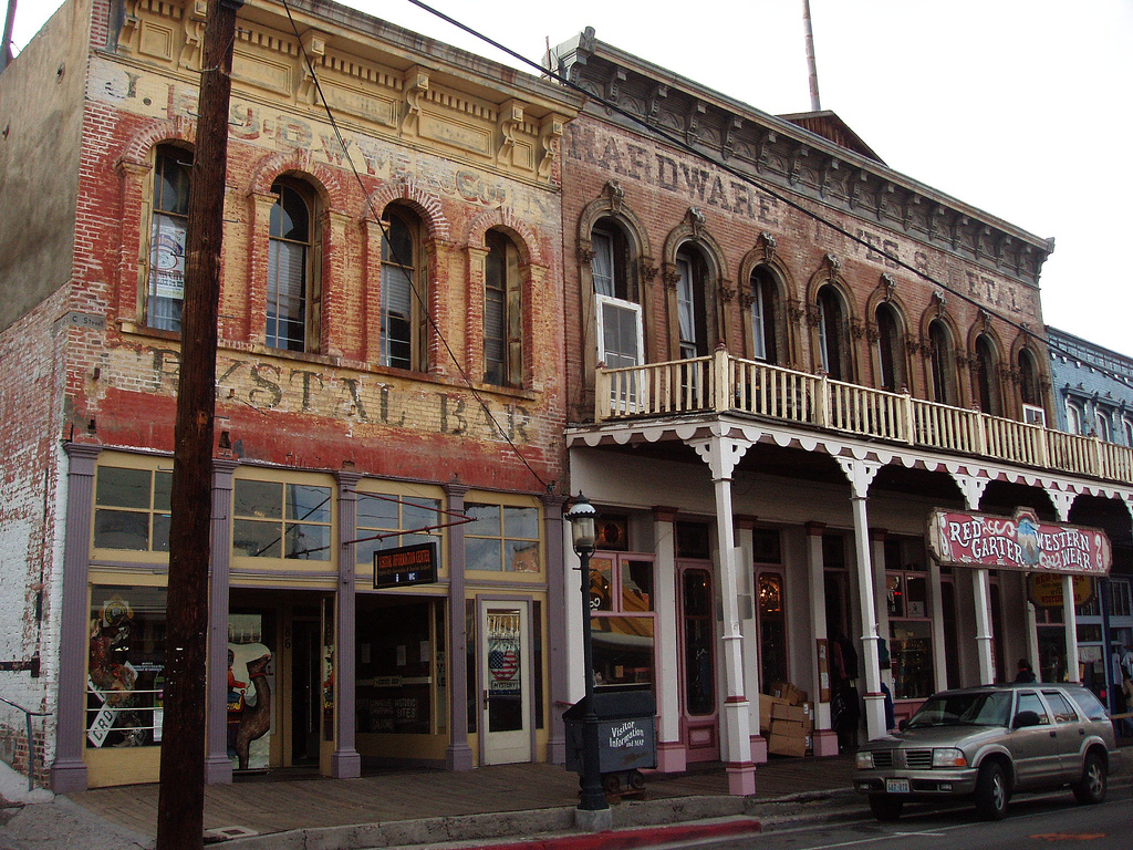
Virginia City Historic District
Monument and historic site · National Register of Historic Places · 6.2 mi
Historic district in Storey and Lyon Counties, Nevada


Fourth Ward School
Museum · 6.1 mi
School building in Virginia City, Nevada

11 more on the map.
Parks, trails and playgrounds15



3 more on the map.
Restaurants and cafes12


Pizza Factory
Restaurant · Pizza · 3.3 mi
185 US Highway 50 E, Dayton


History
Dayton is at the western end of the Twenty-Six Mile Desert at a bend in the Carson River. Immigrants stopping there for water would decide whether to follow the river south or continue west, giving the location its first name, Ponderers Rest. In 1849, Abner Blackburn, while heading for California, discovered a gold nugget in nearby Gold Creek, a tributary of the Carson River.
By 1850, placer miners settled at the mouth of Gold Cañon, working sand bars deposited over the millennia along the path of the creek. At first the settlement was just called "Gold Cañon" or "Gold Cañon Flat". Throughout the 1850s, Dayton served as the commercial hub for miners working in the canyon. In 1857 many Chinese miners came to the area to avoid mining taxes directed at the Chinese in California. With the 1859 discovery of the Comstock Lode, newly founded Gold Hill and Virginia City, 6 miles (10 km) to the north, assumed prominence and most miners headed up the cañon. By 1860 the town was primarily occupied by Chinese miners and it was called "China Town" in the U.S. census of that year. However, soon people began to realize there was more profit in providing milling, goods, and services to the miners and thus came or returned to the area.
From the History section of Dayton, Nevada on Wikipedia, under CC BY-SA 4.0.
Where to stay1
Churches and places of worship2
Shopping3
Gas and EV charging4
Schools, colleges and libraries7
Healthcare1
Map of Dayton
73 places. The map loads OpenStreetMap tiles when you open it.
Climate by month
Monthly table
| Month | High | Low | Rain | Snow |
|---|---|---|---|---|
| Jan | 41°F | 27°F | 1.8 in | 13.0 in |
| Feb | 43°F | 29°F | 2.1 in | 8.7 in |
| Mar | 49°F | 33°F | 1.6 in | 9.3 in |
| Apr | 55°F | 36°F | 0.5 in | 2.3 in |
| May | 64°F | 44°F | 0.7 in | 0.7 in |
| Jun | 74°F | 53°F | 0.6 in | 0.2 in |
| Jul | 84°F | 62°F | 0.2 in | 0.0 in |
| Aug | 82°F | 60°F | 0.2 in | 0.0 in |
| Sep | 74°F | 53°F | 0.3 in | 0.0 in |
| Oct | 61°F | 42°F | 0.7 in | 0.3 in |
| Nov | 49°F | 33°F | 1.1 in | 2.4 in |
| Dec | 40°F | 26°F | 1.9 in | 9.5 in |
U.S. Climate Normals 1991-2020 for Virginia City (6 mi away), NOAA NCEI.
People and cost of living
American Community Survey 5-year estimates, 2020-2024, U.S. Census Bureau. Estimates have margins of error, larger for small towns.
Disaster history
Lyon County has had 11 federal disaster declarations since 2000, most often for severe storms.
- 2023-04-27: Severe Winter Storms, Flooding, Landslides, And Mudslides (Flood)
- 2020-04-04: Covid-19 Pandemic (Biological)
- 2020-03-13: Covid-19 (Biological)
- 2018-06-17: Upper Colony Fire (Fire)
- 2017-02-17: Severe Winter Storms, Flooding, And Mudslides (Severe Storm)
- 2008-01-08: Severe Winter Storms And Flooding (Severe Storm)
OpenFEMA disaster declarations summaries.
Getting there and nearby towns
Carson Airport (CSN) is the nearest airport with scheduled flights listed in OpenStreetMap, 11 miles away.
- Virginia City 6 mi northwest, about 10 min by car
- Stagecoach 11 mi northeast, about 17 min by car
- Washoe Valley 12 mi west, about 20 min by car
- Carson 14 mi southwest, about 22 min by car
- Johnson Lane 17 mi southwest, about 28 min by car
- Indian Hills 18 mi southwest, about 30 min by car
- Sparks 23 mi northwest, about 37 min by car
- Reno 25 mi northwest, about 40 min by car
- South Lake Tahoe 33 mi southwest, about 54 min by car
- Truckee 35 mi west, about 57 min by car
Drive times are estimates from straight-line distance, not routes.
Local news
Headlines from INDB, the NEMICO news database.
Reviews, tips and questions
Loading what members have shared...
Sources and licences
- NCES EDGE (Public domain): public schools
- NOAA NCEI U.S. Climate Normals 1991-2020 (Public domain): climate by month
- OpenFEMA (Public domain): disaster declarations
- OpenStreetMap contributors (ODbL 1.0): places, airports, map data
- U.S. Census Bureau (Public domain): population, income, housing, education, commute
- Wikidata (CC0 1.0): elevation, founding date, time zone, website, landmarks and historic places
- Wikimedia Commons (see each image): photos
- Wikipedia (CC BY-SA 4.0): overview and history text
Photo credits
- 2015-10-30 13 06 28 View east from the west end of Nevada State Route 822 (Dayton Valley Road) in Dayton, Nevada, Famartin, CC BY-SA 4.0
- Dayton, Nevada with Carson City in Background (15678904856), Ken Lund from Reno, Nevada, USA, CC BY-SA 2.0
- Dayton, Nevada with Carson City in Background (15517241368), Ken Lund from Reno, Nevada, USA, CC BY-SA 2.0
- Dayton, Nevada with Carson City in Background (15082679774), Ken Lund from Reno, Nevada, USA, CC BY-SA 2.0
- Dayton and Mound House, Nevada (15678912216), Ken Lund from Reno, Nevada, USA, CC BY-SA 2.0
- Dayton, Nevada with Carson City in Background (15700729921), Ken Lund from Reno, Nevada, USA, CC BY-SA 2.0
- Nevada - Parish House (Virginia City, Nevada) - 20211027143526, Semiautonomous, CC BY-SA 4.0
- McCarthy House NRHP 95001231 Storey County, NV, Jon Roanhaus, CC BY-SA 4.0
- Virginia City-Pipers Opera House-1885, Vivaverdi, CC BY 3.0
- Piper1, William Hoffknecht, CC BY-SA 3.0
- Virginia City Nevada USA, alvito, CC BY 2.0
- C. J. Prescott House NRHP 93000687 Storey County, NV, Jon Roanhaus, CC BY-SA 4.0
- King-McBride Mansion, Robert W. Kerrigan, Public domain
- Henry Piper House NRHP 11000254 Storey County, NV, Jon Roanhaus, CC BY-SA 4.0
- Fourth Ward School, Virginia City, Nevada LCCN2011631000, Carol M. Highsmith, Public domain
- James Webb Space Telescope Pumpkin Carving - by Thomas Herring (50567184771), NASA's James Webb Space Telescope from Greenbelt, MD, USA, CC BY 2.0
- Peck neststraw, Stylocline psilocarphoides (16085005942), Jim Morefield from Nevada, USA, CC BY-SA 2.0
- Home 7, Hawkwind09, CC BY-SA 4.0
- Amelanchier utahensis (5065734639), Matt Lavin from Bozeman, Montana, USA, CC BY-SA 2.0
- Amelanchier utahensis (5065732517), Matt Lavin from Bozeman, Montana, USA, CC BY-SA 2.0
- Malacothrix glabrata (23495239166), Matt Lavin from Bozeman, Montana, USA, CC BY-SA 2.0
- Erigeron aphanactis (23205542090), Matt Lavin from Bozeman, Montana, USA, CC BY-SA 2.0
- Malacothrix glabrata (23521356865), Matt Lavin from Bozeman, Montana, USA, CC BY-SA 2.0
- Chorizanthe watsonii (23225252370), Matt Lavin from Bozeman, Montana, USA, CC BY-SA 2.0
- Astragalus malacus (23424585641), Matt Lavin from Bozeman, Montana, USA, CC BY-SA 2.0
- Malacothrix glabrata (23521356425), Matt Lavin from Bozeman, Montana, USA, CC BY-SA 2.0
- Amelanchier utahensis (5065733701), Matt Lavin from Bozeman, Montana, USA, CC BY-SA 2.0
- Castilleja angustifolia var. dubia (23493927676), Matt Lavin from Bozeman, Montana, USA, CC BY-SA 2.0
- Castilleja angustifolia var. dubia (23224295760), Matt Lavin from Bozeman, Montana, USA, CC BY-SA 2.0
- Balsamorhiza hookeri (23151242169), Matt Lavin from Bozeman, Montana, USA, CC BY-SA 2.0
- Allium anceps (23409458662), Matt Lavin from Bozeman, Montana, USA, CC BY-SA 2.0
- Lupinus malacophyllus (23438787941), Matt Lavin from Bozeman, Montana, USA, CC BY-SA 2.0
- Amsinckia menziesii (23492895696), Matt Lavin from Bozeman, Montana, USA, CC BY-SA 2.0
- Balsamorhiza hookeri (23151241929), Matt Lavin from Bozeman, Montana, USA, CC BY-SA 2.0
- Castilleja angustifolia var. dubia (23224295800), Matt Lavin from Bozeman, Montana, USA, CC BY-SA 2.0
- Allium anceps (22889665174), Matt Lavin from Bozeman, Montana, USA, CC BY-SA 2.0
- Malacothrix glabrata (23225592540), Matt Lavin from Bozeman, Montana, USA, CC BY-SA 2.0
- Allium anceps (23491852206), Matt Lavin from Bozeman, Montana, USA, CC BY-SA 2.0
- Balsamorhiza hookeri (23151242789), Matt Lavin from Bozeman, Montana, USA, CC BY-SA 2.0
- Microseris lindleyi (23139197679), Matt Lavin from Bozeman, Montana, USA, CC BY-SA 2.0


Page built October 30, 2026. Spotted a mistake? Tell us or suggest a place.