


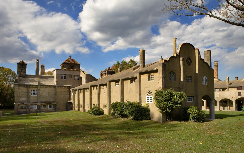
Doylestown, Pennsylvania
Doylestown is a borough of 8,341 people in Bucks County, Pennsylvania, founded in 1745.
Why visit Doylestown
Townapedia lists 33 museums and landmarks, 19 parks and trails, 98 places to eat, 4 places to stay and 4 attractions in and around town.
Highlights include Pine Valley Covered Bridge, County Theater, Mercer Museum and Bridge Valley Bridge.
July is the warmest month, with average highs of 86°F; January lows average 23°F.
Weather in Doylestown
Forecast from the National Weather Service. Full forecast
About Doylestown
Doylestown is a borough and the county seat of Bucks County, Pennsylvania, United States. As of the 2020 census, the population was 8,300. Known for its preserved historic downtown and concentration of cultural institutions, it is a prominent part of Bucks County and a historic town within the Philadelphia metropolitan area. In 2019, Doylestown was named the Best Small-Town Cultural Scene in America by USA Today readers.
From the Wikipedia article Doylestown, Pennsylvania (this version), under CC BY-SA 4.0.
Things to do4

Pine Valley Covered Bridge
Bridge · National Register of Historic Places · 3.2 mi



Museums and landmarks33
Mercer Museum
Museum · National Register of Historic Places · 0.4 mi
Museum in Doylestown, Pennsylvania, USA
84 South Pine Street, Doylestown

Bridge Valley Bridge
Monument and historic site · National Register of Historic Places · 3.5 mi
Bridge in United States of America

Doylestown Historic District
Monument and historic site · National Register of Historic Places · 0.6 mi
Historic district in Pennsylvania, USA

Dyerstown Historic District
Monument and historic site · National Register of Historic Places · 1.9 mi
Historic district in Pennsylvania, United States

Fonthill
Monument and historic site · National Register of Historic Places · 0.5 mi
In Doylestown Township, Pennsylvania

Fonthill, Mercer Museum and Moravian Pottery and Tile Works
Monument and historic site · National Register of Historic Places
Listed on the NRHP in Bucks County, Pennsylvania and home of Mercer tiles

Fordhook Farm
Monument and historic site · National Register of Historic Places · 1.6 mi
Historic districted in Doylestown Township, Penn.

Fretz Farm
Monument and historic site · National Register of Historic Places · 3.0 mi
Building in Pennsylvania, United States

James-Lorah House
Monument and historic site · National Register of Historic Places
Historic house in Pennsylvania, United States

Mechanicsville Village Historic District
Monument and historic site · National Register of Historic Places · 3.4 mi
Historic district in Pennsylvania, United States
Moravian Pottery and Tile Works
Museum · National Register of Historic Places · 0.6 mi
History museum in Doylestown Township, United States of America


Oscar Hammerstein II Farm
Monument and historic site · National Register of Historic Places · 0.9 mi
Building in Pennsylvania, United States
21 more on the map.
Parks, trails and playgrounds19

Peace Valley Park
Park · 3.3 mi
Park in Pennsylvania, United States of America, United States of America

Broad Commons Park Playground
Playground
Doylestown Themed playground with child size version of Fonthill Castle

Maennerchor Field
Park · 1.0 mi
The Doylestown Rugby field where both girls and boys teams play
7 more on the map.
Restaurants and cafes98

Giovanni's on State
Restaurant · Pizza
12 West State Street, Doylestown
Mo off; Tu-Th 10:00-22:00; Fr-Sa 10:00-03:00; Su 10:00-21:00
Great Wall
Restaurant · Chinese · 1.4 mi
807 North Easton Road, Doylestown
Mo, We-Sa 11:00-21:30; Su 12:00-21:15

Nonno's
Cafe
"Hours of operation are subject to change; please check daily."
6 East State Street, Doylestown
Mo 07:00-19:00; Tu-Th 07:00-20:00; Fr 07:00-22:00; Sa 08:00-22:00;...

Steaks on State
Diner · American
44 East State Street, Doylestown
Th 11:00-20:00; Fr-Sa 11:00-21:00; Su-We 11:00-19:00


Finney's Pub
Bar and pub
15 South Main Street, Doylestown
Mo 14:00-26:00, Tu-Sa 13:00-26:00, Su 12:00-26:00
Jules Thin Crust
Restaurant · 0.4 mi
78 South Main Street, Doylestown
Mo-Th 11:00-20:00; Fr-Sa 11:00-21:00; Su 11:30-20:00
86 more on the map.
History
Like most of eastern Pennsylvania, present-day Doylestown was inhabited by the Lenape people prior to European settlement. The Lenape, who called the region Lenapehoking, lived along the waterways of the Delaware Valley for thousands of years before William Penn began colonizing Pennsylvania in 1681. European settlers arrived in the area in the early 18th century, drawn by the fertile land of central Bucks County and the crossroads that would become Doylestown's defining geographic feature.
From the History section of Doylestown, Pennsylvania on Wikipedia, under CC BY-SA 4.0.
Where to stay4
Churches and places of worship10
Doylestown United Methodist Church
Church · Methodist · 0.8 mi
320 East Swamp Road, Doylestown
First Baptist Church of Doylestown
Church · Baptist · 0.8 mi
311 West State Street, Doylestown
Our Lady of Mount Carmel Church
Church · Catholic
235 East State Street, Doylestown
Salem United Church of Christ Education Building
Church
181 East Court Street, Doylestown
Shopping25
Gas and EV charging12
Schools, colleges and libraries26
Healthcare7
Doylestown Health Urgent Care
Clinic and pharmacy · 1.1 mi
4259 West Swamp Road, Doylestown
Map of Doylestown
238 places. The map loads OpenStreetMap tiles when you open it.
Climate by month
Monthly table
| Month | High | Low | Rain |
|---|---|---|---|
| Jan | 39°F | 23°F | 3.2 in |
| Feb | 42°F | 25°F | 2.5 in |
| Mar | 50°F | 31°F | 3.9 in |
| Apr | 63°F | 41°F | 3.9 in |
| May | 72°F | 51°F | 4.3 in |
| Jun | 81°F | 60°F | 4.2 in |
| Jul | 86°F | 65°F | 5.5 in |
| Aug | 84°F | 63°F | 4.9 in |
| Sep | 77°F | 57°F | 4.3 in |
| Oct | 65°F | 45°F | 3.8 in |
| Nov | 54°F | 36°F | 3.4 in |
| Dec | 44°F | 28°F | 4.0 in |
U.S. Climate Normals 1991-2020 for Doylestown Ap (1 mi away), NOAA NCEI.
People and cost of living
American Community Survey 5-year estimates, 2020-2024, U.S. Census Bureau. Estimates have margins of error, larger for small towns.
Disaster history
Bucks County has had 17 federal disaster declarations since 2000, most often for hurricanes.
- 2021-09-10: Remnants Of Hurricane Ida (Hurricane)
- 2020-03-30: Covid-19 Pandemic (Biological)
- 2020-03-13: Covid-19 (Biological)
- 2016-03-23: Severe Winter Storm And Snowstorm (Snowstorm)
- 2014-02-06: Severe Winter Storm (Severe Ice Storm)
- 2013-01-10: Hurricane Sandy (Hurricane)
OpenFEMA disaster declarations summaries.
Getting there and nearby towns
Doylestown Airport (DYL) is the nearest airport with scheduled flights listed in OpenStreetMap, 1 miles away.
- Chalfont 5 mi west, about 7 min by car
- Brittany Farms-The Highlands 6 mi southwest, about 9 min by car
- Montgomeryville 7 mi southwest, about 12 min by car
- Silverdale 8 mi west, about 13 min by car
- Horsham 9 mi south, about 15 min by car
- Lansdale 10 mi southwest, about 15 min by car
- Lambertville 10 mi east, about 17 min by car
- Churchville 11 mi southeast, about 17 min by car
- Willow Grove 12 mi south, about 19 min by car
- Ambler 12 mi southwest, about 19 min by car
Drive times are estimates from straight-line distance, not routes.
Local news
Headlines from INDB, the NEMICO news database.
Reviews, tips and questions
Loading what members have shared...
Sources and licences
- NCES EDGE (Public domain): public schools
- NOAA NCEI U.S. Climate Normals 1991-2020 (Public domain): climate by month
- OpenFEMA (Public domain): disaster declarations
- OpenStreetMap contributors (ODbL 1.0): places, airports, map data
- U.S. Census Bureau (Public domain): population, income, housing, education, commute
- Wikidata (CC0 1.0): elevation, founding date, time zone, website, landmarks and historic places
- Wikimedia Commons (see each image): photos
- Wikipedia (CC BY-SA 4.0): overview and history text
Photo credits
- Main Street NB at State Street Doylestown, Dough4872, CC BY-SA 3.0
- MercerMuseum, KForce at en.wikipedia, CC BY-SA 3.0
- Oscar Hammerstein II Farm 01, Shuvaev, CC BY-SA 3.0
- Bridge Valley Bridge PA 03, Shuvaev, CC BY-SA 3.0
- County Cinema Dtown, Smallbones, Public domain
- MonorovianTileWorks, Unknown author, CC BY-SA 2.5
- Fountain House 2010, Smallbones, Public domain
- Fonthill, KForce at English Wikipedia, CC BY-SA 3.0
- Shaw HD Dtown, Smallbones, Public domain
- Pugh Dungan Hs BucksCo PA, Smallbones, CC0
- Fretz Farm, Smallbones, Public domain
- Mechanicsville Village HD Post Office, Hshuvaeva, CC0
- FORDHOOK FARM, JERRYE & ROY KLOTZ MD, CC BY-SA 3.0
- Fretz Mansion, Doylestown PA 02, Shuvaev, CC BY-SA 3.0
- Dyerstown HD BucksCo PA, Smallbones, CC0
- Spring Valley HD BucksCo PA, Smallbones, CC0
- James Lorah Doylestown, Smallbones, Public domain


Page built October 30, 2026. Spotted a mistake? Tell us or suggest a place.