
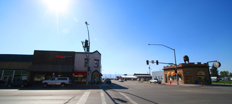


Why visit Driggs
Townapedia lists 3 museums and landmarks, 3 parks and trails, 4 places to eat and 2 places to stay in and around town.
Highlights include Pierre's Hole, Spud Drive-In Theater and Tributary.
July is the warmest month, with average highs of 83°F; January lows average 9°F.
Weather in Driggs
Forecast from the National Weather Service. Full forecast
About Driggs
Driggs is a city in the western United States in eastern Idaho and the county seat of Teton County. Part of the Jackson, WY-ID Micropolitan Statistical Area, it is located in Teton Valley, the headwaters of the Teton River. As of the 2020 census, Driggs had a population of 1,984.
From the Wikipedia article Driggs, Idaho (this version), under CC BY-SA 4.0.
Museums and landmarks3

Pierre's Hole
Monument and historic site · National Register of Historic Places · 1.4 mi
Today's names of historic trapper meeting and battle site

Spud Drive-In Theater
Monument and historic site · National Register of Historic Places · 2.8 mi
Historic district in Idaho, United States of America


Teton County Courthouse
Monument and historic site · National Register of Historic Places · 0.5 mi
Courthouse in Idaho, United States
Parks, trails and playgrounds3


Restaurants and cafes4

Pizzeria Alpino
Restaurant · Italian · 0.4 mi
Handmade pasta and pizza
165 North Main Street, Driggs
Tu-Su 16:00-20:30
Where to stay2

History
The Teton Valley was discovered by John Colter in 1808, a member of the Lewis and Clark Expedition (1804–06). It later became known as Pierre's Hole, in honor of "le grand Pierre" Tivanitagon, and hosted the well-attended 1832 Rendezvous, which was followed by the Battle of Pierre's Hole.
Driggs was founded in 1888 by Benjamin Woodbury Driggs, Jr. and Don Carlos Driggs, whose descendants later moved to Arizona (where most live still), and there founded Western Savings and Loan. John Driggs, a descendant of Don Carlos Driggs, later became the mayor of Phoenix, Arizona in the 1970s.
In 2007, National Geographic magazine listed Driggs as one of the 10 best outdoor recreation destinations in the U.S. The Wall Street Journal posited in 2023 that with the expansion of the Grand Targhee Resort 12 miles away in Alta, Wyoming that Driggs could become the next Jackson Hole (much to the dismay of many of its residents).
From the History section of Driggs, Idaho on Wikipedia, under CC BY-SA 4.0.
Churches and places of worship1
Shopping1
Schools, colleges and libraries7
Healthcare1
Map of Driggs
22 places. The map loads OpenStreetMap tiles when you open it.
Climate by month
Monthly table
| Month | High | Low | Rain |
|---|---|---|---|
| Jan | 33°F | 9°F | 1.9 in |
| Feb | 36°F | 12°F | 1.1 in |
| Mar | 44°F | 20°F | 1.4 in |
| Apr | 54°F | 28°F | 1.9 in |
| May | 65°F | 35°F | 2.3 in |
| Jun | 73°F | 41°F | 2.0 in |
| Jul | 83°F | 48°F | 1.1 in |
| Aug | 82°F | 46°F | 1.2 in |
| Sep | 73°F | 38°F | 1.5 in |
| Oct | 58°F | 29°F | 1.8 in |
| Nov | 44°F | 19°F | 1.5 in |
| Dec | 33°F | 10°F | 1.7 in |
U.S. Climate Normals 1991-2020 for Driggs (0 mi away), NOAA NCEI.
People and cost of living
American Community Survey 5-year estimates, 2020-2024, U.S. Census Bureau. Estimates have margins of error, larger for small towns.
Disaster history
Teton County has had 3 federal disaster declarations since 2000, most often for biologicals.
- 2020-04-09: Covid-19 Pandemic (Biological)
- 2020-03-13: Covid-19 (Biological)
- 2005-09-13: Hurricane Katrina (Hurricane)
OpenFEMA disaster declarations summaries.
Getting there and nearby towns
Jackson Hole Airport (JAC) is the nearest airport with scheduled flights listed in OpenStreetMap, 21 miles away.
- Alta 5 mi northeast, about 8 min by car
- Tetonia 6 mi northwest, about 10 min by car
- Victor 9 mi south, about 14 min by car
- Teton Village 16 mi southeast, about 26 min by car
- Moose Wilson Road 19 mi southeast, about 31 min by car
- Jackson 24 mi southeast, about 39 min by car
- Ashton 29 mi northwest, about 47 min by car
- Rexburg 35 mi west, about 56 min by car
- Ammon 46 mi west, about 1 h 15 min by car
- Idaho Falls 49 mi west, about 1 h 15 min by car
Drive times are estimates from straight-line distance, not routes.
Local news
Headlines from INDB, the NEMICO news database.
Reviews, tips and questions
Loading what members have shared...
Sources and licences
- NCES EDGE (Public domain): public schools
- NOAA NCEI U.S. Climate Normals 1991-2020 (Public domain): climate by month
- OpenFEMA (Public domain): disaster declarations
- OpenStreetMap contributors (ODbL 1.0): places, airports, map data
- U.S. Census Bureau (Public domain): population, income, housing, education, commute
- Wikidata (CC0 1.0): elevation, founding date, time zone, website, landmarks and historic places
- Wikimedia Commons (see each image): photos
- Wikipedia (CC BY-SA 4.0): overview and history text
Photo credits
- Driggs, Idaho by tetraconz, Michael Lemmon from Portland, USA, CC BY 2.0
- Teton County Courthouse, Driggs, Idaho, Ken Lund, CC BY-SA 2.0
- Teton Thai in Driggs Idaho was another culinary joy today. (5928432281), cogdogblog, CC BY 2.0
- Pierre's Hole Historic Site, Lowjumpingfrog, CC BY-SA 3.0
- Teton County Court House, Idahomiller, CC BY-SA 3.0
- Spud Drive In From Highway 33, Lowjumpingfrog, CC BY-SA 3.0
- Quest Kodiaks and Cessna 421, Joseph Palaia, CC BY-SA 3.0

Page built October 30, 2026. Spotted a mistake? Tell us or suggest a place.