


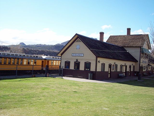


Durango, Colorado
Durango is a city of 19,411 people in La Plata County, Colorado, founded in 1881.
Why visit Durango
Townapedia lists 12 museums and landmarks, 35 parks and trails, 76 places to eat, 29 places to stay and 9 attractions in and around town.
Highlights include Fort Lewis College, Animas City Theatre, Rochester Hotel and Durango and Silverton Narrow Gauge Railroad.
July is the warmest month, with average highs of 85°F; January lows average 13°F, and about 64 inches of snow fall in a normal year.
Weather in Durango
Forecast from the National Weather Service. Full forecast
About Durango
Durango is the home rule city and the county seat of La Plata County, Colorado, United States. The city's population was 19,071 at the 2020 census, making it the most populous city in the county. Durango is the home of Fort Lewis College.
From the Wikipedia article Durango, Colorado (this version), under CC BY-SA 4.0.
Things to do9
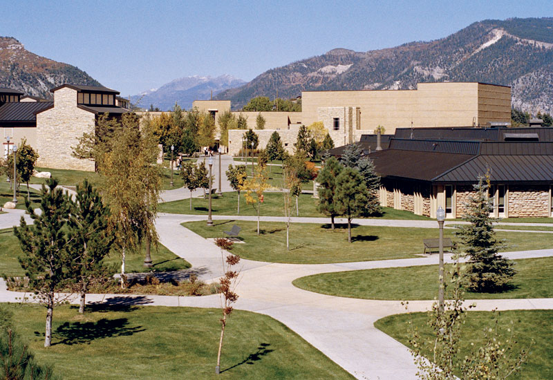
Fort Lewis College
School · 0.8 mi
Public liberal arts college in Durango, Colorado, United States



Museums and landmarks12

Rochester Hotel
Monument and historic site · National Register of Historic Places · 0.5 mi
Historic building in Durango, Colorado, United States
726 East 2nd Avenue, Durango

Durango and Silverton Narrow Gauge Railroad
Monument and historic site · National Register of Historic Places · 2.3 mi
Heritage railroad in California, US

Durango High School
Monument and historic site · National Register of Historic Places · 0.9 mi
High school in Durango, La Plata County, Colorado, United States

Main Avenue Historic District
Monument and historic site · National Register of Historic Places · 0.7 mi
Historic district in Durango, Colorado

The Powerhouse Science Centre
Museum · 1.0 mi
1333 Camino del Rio, Durango
Mo,We,Sa 09:30-17:30; Fr 13:00-17:30; Su 11:30-17:30; Tu,Th closed


Durango Discovery Museum
Museum · 1.0 mi
Science museum in Durango, Colorado

Parks, trails and playgrounds35


23 more on the map.
Restaurants and cafes76

Baskin-Robbins
Ice cream · Ice Cream · 0.8 mi
32 Town Plaza, Durango
Mo-Th 11:00-21:00; Fr-Sa 11:00-22:00; Su 11:00-21:00


Durango Coffee Company
Cafe · Cake, Tea, Sandwich, Coffee Shop, Breakfast, Bagel · 0.6 mi
730 Main Avenue
Mo-Su 06:00-19:00

Ore House
Restaurant · Steak House · 0.5 mi
Steakhouse that opened in 1972. A severe kitchen fire on 2024-01-01 caused smoke damage, and the restaurant closed for restoration....
147 East College Drive, Durango
64 more on the map.
History
Durango was initially inhabited by members of the Ute Native American tribe.
The town was organized from September 1880 to April 1881 by the Denver and Rio Grande Railroad (D&RG, later known as the Denver and Rio Grande Western railroad) as part of their efforts to reach Silverton, Colorado, and service the San Juan mining district, the goal of their "San Juan Extension" built from Alamosa, Colorado. The D&RG chose a site in the Animas Valley close to the Animas River near what is now the Downtown Durango Historic Business District for its railroad facilities following a brief and most likely perfunctory negotiation with the other establishment in the area known as Animas City, two miles (3.2 km) to the north. The city was named by ex-Colorado Governor Alexander C. Hunt, a friend of D&RG President William Jackson Palmer, after Durango, Mexico, based on his favorable impression of that city resulting from a scouting trip undertaken on behalf of Palmer.
The Durango, Colorado, post office opened on November 19, 1880, and the Town of Durango was incorporated on April 27, 1881.
From the History section of Durango, Colorado on Wikipedia, under CC BY-SA 4.0.
Where to stay29
Churches and places of worship22
Sacred Heart Catholic Church
Church · Roman Catholic
255 East 5th Avenue, Durango
Shopping25
Gas and EV charging12
Schools, colleges and libraries30
Colorado Connections Academy @ Durango
School · 1.2 mi
150 Tech Center Drive, Durango
Healthcare4
Map of Durango
250 places. The map loads OpenStreetMap tiles when you open it.
Climate by month
Monthly table
| Month | High | Low | Rain | Snow |
|---|---|---|---|---|
| Jan | 39°F | 13°F | 2.2 in | 19.4 in |
| Feb | 45°F | 19°F | 1.7 in | 15.4 in |
| Mar | 54°F | 25°F | 1.3 in | 5.3 in |
| Apr | 63°F | 30°F | 1.2 in | 3.8 in |
| May | 71°F | 37°F | 1.2 in | 0.2 in |
| Jun | 81°F | 46°F | 0.5 in | 0.0 in |
| Jul | 85°F | 53°F | 1.9 in | 0.0 in |
| Aug | 82°F | 52°F | 2.3 in | 0.0 in |
| Sep | 76°F | 44°F | 2.2 in | 0.0 in |
| Oct | 64°F | 33°F | 1.9 in | 1.1 in |
| Nov | 50°F | 23°F | 1.5 in | 5.5 in |
| Dec | 40°F | 13°F | 1.6 in | 13.0 in |
U.S. Climate Normals 1991-2020 for Durango (2 mi away), NOAA NCEI.
People and cost of living
American Community Survey 5-year estimates, 2020-2024, U.S. Census Bureau. Estimates have margins of error, larger for small towns.
Disaster history
La Plata County has had 7 federal disaster declarations since 2000, most often for fires.
- 2020-03-28: Covid-19 Pandemic (Biological)
- 2020-03-13: Covid-19 (Biological)
- 2005-09-05: Hurricane Katrina Evacuation (Coastal Storm)
- 2002-06-25: Valley Fire (Fire)
- 2002-06-19: Wildfires (Fire)
- 2002-06-11: Missionary Ridge Fire (Fire)
OpenFEMA disaster declarations summaries.
Getting there and nearby towns
Animas Air Park (AMK) is the nearest airport with scheduled flights listed in OpenStreetMap, 4 miles away.
- Bayfield 16 mi east, about 25 min by car
- Ignacio 17 mi southeast, about 27 min by car
- Mancos 24 mi west, about 38 min by car
- Center Point 28 mi south, about 44 min by car
- Aztec 31 mi south, about 51 min by car
- Spencerville 32 mi south, about 51 min by car
- Flora Vista 34 mi south, about 55 min by car
- South River 35 mi south, about 56 min by car
- Bloomfield 36 mi south, about 59 min by car
- Farmington 39 mi southwest, about 1 h by car
Drive times are estimates from straight-line distance, not routes.
Local news
Headlines from INDB, the NEMICO news database.
Reviews, tips and questions
Loading what members have shared...
Sources and licences
- NCES EDGE (Public domain): public schools
- NOAA NCEI U.S. Climate Normals 1991-2020 (Public domain): climate by month
- OpenFEMA (Public domain): disaster declarations
- OpenStreetMap contributors (ODbL 1.0): places, airports, map data
- U.S. Census Bureau (Public domain): population, income, housing, education, commute
- Wikidata (CC0 1.0): elevation, founding date, time zone, website, landmarks and historic places
- Wikimedia Commons (see each image): photos
- Wikipedia (CC BY-SA 4.0): overview and history text
Photo credits
- Sacred Heart Catholic Church in Durango Colorado, Always dreamin, CC BY-SA 4.0
- Strater Hotel - Durango, CO, Quintin Soloviev, CC BY 4.0
- D^RGW 492 Durango turntable 8-65x - Flickr - drewj1946, Drew Jacksich from San Jose, CA, The Republic of California, CC BY-SA 2.0
- Durango CO 4, Unknown author, CC BY-SA 3.0
- Durango train cars, Kevin Payravi, CC BY-SA 4.0
- Durango station - panoramio, Peter K., CC BY-SA 3.0
- Durango and Silverton Narrow Gauge Railroad Passenger Cars - July 2010 - 01, Ken Lund, CC BY-SA 2.0
- Durango & Silverton Narrow Gauge Railroad Station - July 2010 - 01, Ken Lund, CC BY-SA 2.0
- Durango and Silverton Narrow Gauge Railroad No. 481 - July 2010 - 04, Ken Lund, CC BY-SA 2.0
- Durango and Silverton Narrow Gauge Railroad No. 481 - July 2010 - 02, Ken Lund, CC BY-SA 2.0
- Durango and Silverton Narrow Gauge Railroad No. 481 - July 2010 - 03, Ken Lund, CC BY-SA 2.0
- Rochester Hotel, Ty Nigh, CC BY 2.0
- Durango and Silverton Narrow Gauge Railroad 1, pixelFire, CC BY-SA 3.0
- Durango High School, Ken Lund, CC BY-SA 2.0
- Durango CO 2, Unknown author, CC BY-SA 3.0
- Fort Lewis College Community Concert Hall, Fort Lewis College, CC BY-SA 3.0
- Durango Discovery Museum, Ijon, CC BY-SA 3.0
- Saint Columba Catholic Church in Durango Colorado, Always dreamin, CC BY-SA 4.0
- Gold King Mine - August 14, 2015 (20629444575), USEPA Environmental-Protection-Agency, Public domain
- 16 21 2376 buggy, Dsdugan, CC0
- 16 21 2397 velocipede, Dsdugan, CC0
- 16 21 2369 cars, Dsdugan, CC0
- 16 21 2426 curtiss, Dsdugan, CC0
- 16 21 2419 curtiss, Dsdugan, CC0
- 16 21 2355 steam car, Dsdugan, CC0
- RGS 42, Joe Weigman, CC BY-SA 4.0
- 16 21 2404 wheelchair, Dsdugan, CC0
- 16 21 2362 museum, Dsdugan, CC0
- Silver Vista observation car Denver and Rio Grande, Sanborn Souvenir Company, Denver, Public domain
- 20170920 190004 HDR, Diane Goullard, CC BY-SA 4.0


Page built October 30, 2026. Spotted a mistake? Tell us or suggest a place.