


Edinburg, Texas
Edinburg is a city of 104,550 people in Hidalgo County, Texas, founded in 1908.
Why visit Edinburg
Townapedia lists 14 museums and landmarks, 40 parks and trails, 68 places to eat, 5 places to stay and 5 attractions in and around town.
Highlights include AMC Edinburg 18, University of Texas Rio Grande Valley, Museum of South Texas History and International Museum of Art & Science.
August is the warmest month, with average highs of 98°F; January lows average 49°F.
Weather in Edinburg
Forecast from the National Weather Service. Full forecast
About Edinburg
Edinburg is a city in and the county seat of Hidalgo County, Texas, United States. The population was 100,243 at the 2020 census, and in 2025, its estimated population was 110,700, making it the second-largest city in Hidalgo County, and the third-largest city in the larger Rio Grande Valley region.
From the Wikipedia article Edinburg, Texas (this version), under CC BY-SA 4.0.
Things to do5


University of Texas Rio Grande Valley
School · 1.6 mi
Public research university in Texas, U.S.A.
1201 West University Drive, Edinburg
Cinemark Movie Bistro - Edinburg
Cinema and theater · 4.3 mi
2001 West Trenton Road, Edinburg
Museums and landmarks14

Museum of South Texas History
Museum · 1.2 mi
Non-profit organization in the USA
200 North Closner Boulevard, Edinburg
Tu-Sa 10:00-17:00; Su 13:00-17:00; PH off

2 more on the map.
Parks, trails and playgrounds40

Edinburg Scenic Wetlands and World Birding Center
Hiking and trails · 2.2 mi
714 South Raul Longoria Road, Edinburg
Mo-Sa 08:00-17:00; Su 12:00-17:00

Beethoven Park
Park · 2.6 mi
2215 South Veterans Boulevard, Edinburg
Mo-Fr 16:00-20:00; Sa-Su 06:00-20:00


Kid's Wonderland
Playground · 4.8 mi
8016 North 10th Street
Mo-Th 11:00-20:00; Fr 11:00-21:00; Sa 10:00-21:00; Su 11:00-19:00
Hidalgo County Sheriff's Posse Arena
Sports field and stadium · 3.6 mi
Rodeo
West Wisconsin Road, Edinburg
28 more on the map.
Restaurants and cafes68

7 Brew
Cafe · Coffee Shop · 4.8 mi
3000 West Trenton Road, Edinburg
Su-Th 05:30-22:00, Fr-Sa 05:30-23:00

Kurai Sushi & Chinese Buffet
Restaurant · Sushi, Chinese · 4.8 mi
3020 West Trenton Road, Edinburg
Mo-Su 11:00-21:00
McAlister's Deli
Restaurant · Sandwich · 4.5 mi
3832 South McColl Road, Edinburg
Mo-Th 10:30-21:00; Fr-Sa 10:30-22:00; Su 10:30-21:00

Logan's Roadhouse
Diner · American · 5.1 mi
7612 North 10th Street, McAllen
Su-Th 11:00-22:00; Fr-Sa 11:00-23:00
Olive Garden
Restaurant · Italian · 5.0 mi
7812 North 10th Street, McAllen
Su-Th 11:00-22:00; Fr-Sa 11:00-23:00
Beary Boba
Cafe · Bubble Tea · 3.1 mi
2506 West Freddy Gonzalez Drive, Edinburg
Mo-Fr 12:00-22:00; Sa-Su 10:00-22:00
56 more on the map.
History
In 1908, John Closner, William Briggs, Argyle McAllen, Plutarco de la Viña, and Dennis B. Chapin began to develop a new community at this site. The town square was located at the current crossroads of U.S. Highway 281 and State Highway 107. The town was named "Chapin" in honor of one of the developers. A local myth relates that Edinburg became the county seat of Hidalgo County in a dramatic, nighttime covert operation in which the county records were removed from the previous county seat.
In 2013, the city council voted to annex about 2,000 acres (810 ha) of area into the city limits.
From the History section of Edinburg, Texas on Wikipedia, under CC BY-SA 4.0.
Where to stay5
Churches and places of worship17
Edinburg Seventh-day Adventist Church
Church · Seventh Day Adventist · 3.7 mi
602 W. Wisconsin Road, Edinbug
Immaculate Conception Catholic Church
Church · Roman Catholic · 5.3 mi
901 Church Street, San Juan
Shopping23
Gas and EV charging20
Schools, colleges and libraries90
Healthcare22
Action Behavior Centers - ABA Therapy for Autism
Clinic and pharmacy · 4.9 mi
505 West Owassa Road, Edinburg
McAllen Emergency Room
Clinic and pharmacy · 5.6 mi
6700 North 10th Street, McAllen
H-E-B Pharmacy
Clinic and pharmacy · 3.3 mi
2700 West Freddy Gonzalez Drive, Edinburg
Map of Edinburg
250 places. The map loads OpenStreetMap tiles when you open it.
Climate by month
Monthly table
| Month | High | Low | Rain |
|---|---|---|---|
| Jan | 70°F | 49°F | 1.3 in |
| Feb | 75°F | 54°F | 0.9 in |
| Mar | 80°F | 58°F | 1.4 in |
| Apr | 86°F | 65°F | 1.4 in |
| May | 92°F | 71°F | 2.6 in |
| Jun | 95°F | 75°F | 2.8 in |
| Jul | 97°F | 77°F | 2.5 in |
| Aug | 98°F | 77°F | 1.8 in |
| Sep | 93°F | 73°F | 4.3 in |
| Oct | 89°F | 66°F | 2.5 in |
| Nov | 79°F | 58°F | 1.3 in |
| Dec | 73°F | 51°F | 1.1 in |
U.S. Climate Normals 1991-2020 for Edinburg (1 mi away), NOAA NCEI.
People and cost of living
American Community Survey 5-year estimates, 2020-2024, U.S. Census Bureau. Estimates have margins of error, larger for small towns.
Disaster history
Hidalgo County has had 24 federal disaster declarations since 2000, most often for hurricanes.
- 2025-05-21: Severe Storms And Flooding (Flood)
- 2024-07-09: Hurricane Beryl (Hurricane)
- 2021-02-19: Severe Winter Storms (Severe Ice Storm)
- 2021-02-14: Severe Winter Storm (Severe Ice Storm)
- 2020-07-26: Hurricane Hanna (Hurricane)
- 2020-03-25: Covid-19 Pandemic (Biological)
OpenFEMA disaster declarations summaries.
Getting there and nearby towns
McAllen-Miller International Airport (MFE) is the nearest airport with scheduled flights listed in OpenStreetMap, 11 miles away.
- César Chávez 3 mi east, about 4 min by car
- Doolittle 4 mi northeast, about 6 min by car
- Murillo 4 mi southeast, about 7 min by car
- Lopezville 5 mi south, about 8 min by car
- San Carlos 6 mi east, about 9 min by car
- Muniz 6 mi southeast, about 9 min by car
- North Alamo 7 mi south, about 12 min by car
- McAllen 9 mi southwest, about 14 min by car
- San Juan 9 mi south, about 14 min by car
- Brownsville 48 mi southeast, about 1 h 15 min by car
Drive times are estimates from straight-line distance, not routes.
Local news
Headlines from INDB, the NEMICO news database.
Reviews, tips and questions
Loading what members have shared...
Sources and licences
- NCES EDGE (Public domain): public schools
- NOAA NCEI U.S. Climate Normals 1991-2020 (Public domain): climate by month
- OpenFEMA (Public domain): disaster declarations
- OpenStreetMap contributors (ODbL 1.0): places, airports, map data
- U.S. Census Bureau (Public domain): population, income, housing, education, commute
- Wikidata (CC0 1.0): elevation, founding date, time zone, website, landmarks and historic places
- Wikimedia Commons (see each image): photos
- Wikipedia (CC BY-SA 4.0): overview and history text
Photo credits
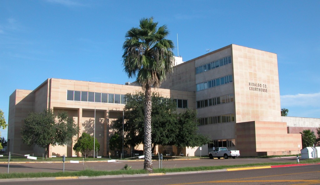
- Hidalgo County Courthouse, Danny20111993 at English Wikipedia, CC BY-SA 3.0
- Race and ethnicity 2020 Edinburg, TX, CensusDots, CC BY-SA 4.0
- Old Hidalgo County Jail Edinburg Texas 2021, Larry D. Moore, CC BY 4.0
- Edinburg, TX, USA - panoramio - Mig Esc (2), Mig Esc, CC BY 3.0
- Edinburg, TX, USA - panoramio, Mig Esc, CC BY 3.0
- Edinburg, TX, USA - panoramio - Mig Esc, Mig Esc, CC BY 3.0
- Edinburg, TX, USA - panoramio - Mig Esc (3), Mig Esc, CC BY 3.0
- Edinburg, TX, USA - panoramio - Mig Esc (4), Mig Esc, CC BY 3.0
- Edinburg, TX, USA - panoramio - Mig Esc (1), Mig Esc, CC BY 3.0
- Edinburg, TX, USA - panoramio (5), Alex Garrido, CC BY 3.0
- Edinburg, TX, USA - panoramio (3), Alex Garrido, CC BY 3.0
- Edinburg, TX, USA - panoramio (7), Alex Garrido, CC BY 3.0
- Edinburg, TX, USA - panoramio - Mig Esc (5), Mig Esc, CC BY 3.0
- Edinburg, TX banner, Mig Esc, CC BY 3.0
- Edinburg, TX, USA - panoramio (1), Alex Garrido, CC BY 3.0
- Edinburg, TX, USA - panoramio (6), Alex Garrido, CC BY 3.0
- Edinburg, TX, USA - panoramio (4), Alex Garrido, CC BY 3.0
- Edinburg, TX, USA - panoramio (2), Alex Garrido, CC BY 3.0
- Old Hidalgo County Jail Historical Markers, Larry D. Moore, Public domain
- AtshaniAli, Shahinyarmohamadi, CC BY-SA 4.0
- County of Hidalgo, Texas - Veteran's Memorial (Pre 2020), Renanville, CC0
- County of Hidalgo, Texas Courthouse (built circa 1954) - Eastward view, Renanville, CC0
- The sundial at the University of Texas Pan American. This beautiful university landmark sits in the main corridor between the east parking lot and the main bronc walkway. - panoramio, Alex Garrido, CC BY 3.0
- Science Building UTPA - panoramio, Alex Garrido, CC BY 3.0
- Blue Wall, Science Building, UTPA - panoramio, Alex Garrido, CC BY 3.0
- UTPA Tree Walkway - panoramio, Alex Garrido, CC BY 3.0
- Right in the heart of the Science Building, University of Texas Pan American - panoramio, Alex Garrido, CC BY 3.0
- Engineering and Computer Science Building, UTPA - panoramio, Alex Garrido, CC BY 3.0
- Mathematics and Science Building, UTPA - panoramio, Alex Garrido, CC BY 3.0
- I just love this tree and area in general. It is a great place to sit and relax. There is a huge tree that makes a very relaxing sound when there is a strong breeze. - panoramio, Alex Garrido, CC BY 3.0
- UTPA Library - panoramio, Alex Garrido, CC BY 3.0
- The UTPA library - panoramio, Alex Garrido, CC BY 3.0
- Red Bordered Pixie (Melanis pixe), Anne Toal from US, CC BY 2.0
- University Library, The University of Texas Pan American - panoramio, Alex Garrido, CC BY 3.0
- Physical Science East Building, UTPA - panoramio, Alex Garrido, CC BY 3.0
- Executive Building, UTPA - panoramio, Alex Garrido, CC BY 3.0
- Health Sciences and Human Services West, UTPA - panoramio, Alex Garrido, CC BY 3.0
- UTPA Parking Lots - panoramio, Alex Garrido, CC BY 3.0
- ^UTPA quad. A place where most organizations and clubs have their major outdoor events. In this picture you can also see the Student Union, the College of Social and Behavioral Sciences, the College..., Alex Garrido, CC BY 3.0
- Front of the University of Texas Pan American. In this picture, the famous bronc statue, the executive tower (right in front of the statue), the visitors parking lot. ^UTPA ^PanAm - panoramio, Alex Garrido, CC BY 3.0


Page built October 30, 2026. Spotted a mistake? Tell us or suggest a place.