
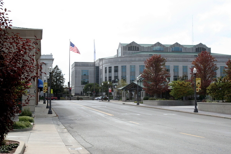

Edwardsville, Illinois
Edwardsville is a city of 26,474 people in Madison County, Illinois, founded in 1818.
Why visit Edwardsville
Townapedia lists 30 museums and landmarks, 48 parks and trails, 125 places to eat, 6 places to stay and 6 attractions in and around town.
Highlights include AMC Edwardsville 12, The Wildley Theatre, Benjamin Stephenson House and Berleman House.
July is the warmest month, with average highs of 87°F; January lows average 22°F.
Weather in Edwardsville
Forecast from the National Weather Service. Full forecast
About Edwardsville
Edwardsville is a city in Madison County, Illinois, United States, and its county seat. The population was 26,808 as of the 2020 census. The city was named in honor of Ninian Edwards, former governor of the Illinois Territory. Edwardsville is a part of Southern Illinois and the Metro East region within Greater St.
From the Wikipedia article Edwardsville, Illinois (this version), under CC BY-SA 4.0.
Things to do6

Cleaon Etzkorn Bandstand
Cinema and theater · 2.3 mi
112 South Kansas Street, Edwardsville
James F Metcalf Student Experimental Theater
Cinema and theater · 0.8 mi
47 Circle Drive, Edwardville

Museums and landmarks30

Benjamin Stephenson House
Monument and historic site · National Register of Historic Places · 2.3 mi
Edwardsville, Illinois, NRHP-listed
Berleman House
Monument and historic site · National Register of Historic Places · 2.2 mi
Historic house in Illinois, United States
Edwardsville Chapter House
Monument and historic site · National Register of Historic Places · 2.2 mi
Building in Illinois, United States
Glen Carbon Grade School
Monument and historic site · National Register of Historic Places · 3.0 mi
School building in Glen Carbon, Illinois
Glen Carbon Village Hall and Firehouse
Monument and historic site · National Register of Historic Places · 2.9 mi
Government building in Glen Carbon, Illinois
John Weir House
Monument and historic site · National Register of Historic Places · 2.3 mi
Historic house in Illinois, United States
LeClaire Historic District
Monument and historic site · National Register of Historic Places · 2.2 mi
Historic district in Illinois, United States
Narodni Sin
Monument and historic site · National Register of Historic Places · 2.4 mi
Building in Illinois, United States
St. Louis Street Historic District
Monument and historic site · National Register of Historic Places · 1.8 mi
Historic district in Illinois, United States

Edwardsville Arts Center
Museum · 0.8 mi
6165 Center Grove Road, Edwardsville
We-Fr 10:00-15:00; Sa 11:00-15:00
1820 Colonel Benjamin Stephenson House
Museum · 2.3 mi
409 South Buchanan Street, Edwardsville
Nickle Plate Station
Monument and historic site · 2.3 mi
Visitors center and historic building.
600 Troy Road, Edwardsville
18 more on the map.
Parks, trails and playgrounds48

Bohm Woods Nature Preserve
Hiking and trails · 1.8 mi
State park in Illinois, USA
4200 Bohm School Road, Edwardsville
sunrise-sunset
Willam and E. Bohm Memorial Nature Preserve
Hiking and trails · 2.0 mi
4200 Bohm School Road, Edwardsville
sunrise-sunset
E Dora Bohm Memorial Nature Preserve
Hiking and trails · 1.7 mi
4200 Bohm School Road, Edwardsville
sunrise-sunset



JSC Boundless Playground
Playground · 1.4 mi
Wheelchair accessible play structures
6364 Center Grove Rd, Edwardsville
Willam C Drda Woods Nature Preserve
Hiking and trails · 1.9 mi
City of Edwardsville purchased this land adjacent to the Bohm Nature Preserve using a grant from Illinois Clean Energy. It is called the...
5403 New Poag Road, Edwardsville
sunrise-sunset
36 more on the map.
Restaurants and cafes125

54th Street Grill and Bar
Restaurant · American, Bar And Grill · 1.9 mi
Closed on Thanksgiving and Christmas Day.
6660 Edwardsville Crossing Drive, Edwardsville
Su-Th 11:00-22:30; Fr-Sa 11:00-23:30; Dec 24 11:00-20:00; Dec 25 off

Bann Thai
Restaurant · Thai · 0.8 mi
4 Club Centre Court, Edwardsville
Mo-Sa 11:00-21:30; Su 12:00-21:00
Bella Milano
Restaurant · Italian · 0.5 mi
1063 South State Rt 157, Edwardsville
Su-Th 11:00-21:00; Fr,Sa 11:00-22:30
Buffalo Wild Wings
Restaurant · Wings · 2.0 mi
249 Harvard Drive, Edwardsville
Mo-Th 11:00-24:00; Fr-Sa 11:00-25:00; Su 11:00-23:00
Dewey's Pizza
Restaurant · Pizza · 2.3 mi
112 East Vandalia Street, Edwardsville
Mo-Th 10:00-23:00; Fr-Sa 11:00-23:00; Su 16:00-22:00
Doc's Smokehouse
Restaurant · Barbecue · 0.6 mi
6108 Shoger Drive, Edwardsville
Mo-Fr 11:00 - 20:00; Su 11:00-19:00
El Maguey
Restaurant · Mexican · 2.1 mi
1534 Troy Road, Edwardsville
Mo-Th, Sa 11:00-22:00; Fr 11:00-22:30; Su 11:00-21:00

Gulf Shores Restaurant & Grill
Restaurant · Seafood, Cajun · 1.9 mi
215 Harvard Drive, Edwardsville
Mo-Th 11:00-21:00; Fr-Sa 11:00-22:00; Su 10:30-21:00
Hawaiian Bros Island Grill
Restaurant · Hawaiian · 2.1 mi
2386 Troy Road, Edwardsville
Mo-Su 11:00-24:00
Hotshots Sports Bar and Grill
Restaurant · Burger, Pizza · 1.4 mi
2511 South State Route 157, Edwardsville
Su-Th 09:00-14:00
113 more on the map.
History
Edwardsville was incorporated in 1818. The first European-American settler was Thomas Kirkpatrick, who came in 1805, laid out a community, and served as the Justice of the Peace. He named the community after his friend Ninian Edwards, then territorial governor of Illinois. (Illinois did not become a state until 1818.) The Edwards Trace, a key trail in the settlement of Central Illinois, used Edwardsville as a northward launching point.
In 1868 The Bank of Edwardsville was founded. It was purchased by Champaign, Illinois-based Busey Bank in 2019.
In 1890, St. Louis industrialist N. O. Nelson chose a tract of land just south of Edwardsville to build plumbing factories. He also built a model workers' cooperative village called Leclaire. He offered workers fair wages with reasonable working hours and a share of the profits. He named the village in honor of the French economist Edme-Jean Leclaire. The village also provided educational and recreational opportunities and made it financially possible for anyone to own a home. Unlike company towns such as Pullman near Chicago, the welfare and quality of life for the workers and their families was a major concern.
From the History section of Edwardsville, Illinois on Wikipedia, under CC BY-SA 4.0.
Where to stay6
Hampton Inn & Suites St. Louis-Edwardsville
Motel and hotel · 2.8 mi
5723 Heritage Crossing Drive, Glen Carbon
Holiday Inn Express & Suites
Motel and hotel · 0.6 mi
1000 Plummer Drive, Edwardsville
Churches and places of worship24
Eden United Church of Christ
Church · United Church Of Christ · 2.2 mi
911 North 2nd Street, Edwardsville
Saint Cecilia Catholic Church
Church · Roman Catholic · 2.1 mi
155 North Main St;North Main Street, Glen Carbon
Shopping26
Gas and EV charging13
MotoMart Convenience Store
Gas station · 0.9 mi
1 Club Centre Court, Edwardsville
Schools, colleges and libraries29
Healthcare8
HSHS Medical Group Multispecialty Care
Clinic and pharmacy · 0.7 mi
1188 South State Route 157, Edwardsville
Map of Edwardsville
250 places. The map loads OpenStreetMap tiles when you open it.
Climate by month
Monthly table
| Month | High | Low | Rain |
|---|---|---|---|
| Jan | 39°F | 22°F | 2.5 in |
| Feb | 44°F | 25°F | 2.5 in |
| Mar | 54°F | 35°F | 3.5 in |
| Apr | 66°F | 45°F | 4.9 in |
| May | 75°F | 56°F | 5.5 in |
| Jun | 84°F | 66°F | 3.4 in |
| Jul | 87°F | 69°F | 4.0 in |
| Aug | 86°F | 67°F | 3.3 in |
| Sep | 80°F | 60°F | 3.4 in |
| Oct | 68°F | 48°F | 2.9 in |
| Nov | 54°F | 36°F | 3.4 in |
| Dec | 44°F | 27°F | 2.6 in |
U.S. Climate Normals 1991-2020 for Alton - Melvin Price L&D (10 mi away), NOAA NCEI.
People and cost of living
American Community Survey 5-year estimates, 2020-2024, U.S. Census Bureau. Estimates have margins of error, larger for small towns.
Disaster history
Madison County has had 8 federal disaster declarations since 2000, most often for tornados.
- 2021-12-13: Severe Storms, Straight-Line Winds, And Tornadoes (Tornado)
- 2020-03-26: Covid-19 Pandemic (Biological)
- 2020-03-13: Covid-19 (Biological)
- 2019-09-19: Severe Storms And Flooding (Flood)
- 2008-06-24: Severe Storms And Flooding (Severe Storm)
- 2007-02-09: Severe Winter Storm (Severe Ice Storm)
OpenFEMA disaster declarations summaries.
Getting there and nearby towns
Saint Louis Regional Airport (ALN) is the nearest airport with scheduled flights listed in OpenStreetMap, 7 miles away.
- Glen Carbon 2 mi south, about 4 min by car
- Roxana 4 mi northwest, about 6 min by car
- South Roxana 4 mi west, about 6 min by car
- Maryville 4 mi south, about 7 min by car
- Mitchell 5 mi west, about 9 min by car
- Pontoon Beach 6 mi southwest, about 9 min by car
- Hartford 6 mi west, about 9 min by car
- Troy 7 mi southeast, about 11 min by car
- Wood River 7 mi northwest, about 11 min by car
- Collinsville 8 mi south, about 13 min by car
Drive times are estimates from straight-line distance, not routes.
Local news
Headlines from INDB, the NEMICO news database.
Reviews, tips and questions
Loading what members have shared...
Sources and licences
- NCES EDGE (Public domain): public schools
- NOAA NCEI U.S. Climate Normals 1991-2020 (Public domain): climate by month
- OpenFEMA (Public domain): disaster declarations
- OpenStreetMap contributors (ODbL 1.0): places, airports, map data
- U.S. Census Bureau (Public domain): population, income, housing, education, commute
- Wikidata (CC0 1.0): elevation, founding date, time zone, website, landmarks and historic places
- Wikimedia Commons (see each image): photos
- Wikipedia (CC BY-SA 4.0): overview and history text
Photo credits
- Downtown Edwardsville Illinois, Illinois2011 (Tyler Warren), Public domain
Page built October 30, 2026. Spotted a mistake? Tell us or suggest a place.