
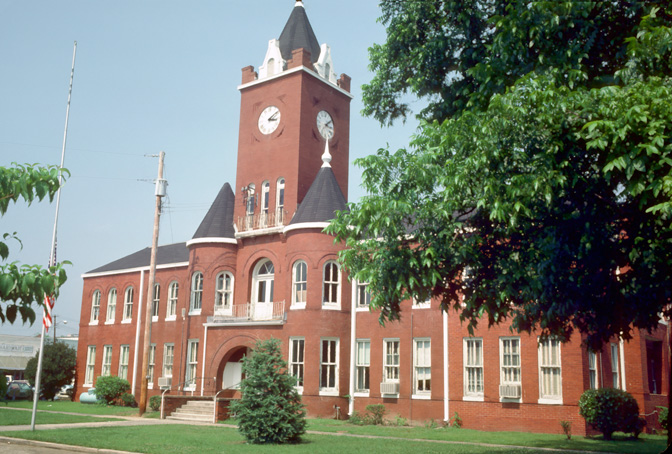


Elba, Alabama
Elba is a city of 3,468 people in Coffee County, Alabama, founded in 1851.
Why visit Elba
Townapedia lists 3 museums and landmarks, 4 parks and trails, 2 places to eat, 1 place to stay and 1 attraction in and around town.
Highlights include Coffee County Courthouse, Pea River Power Company Hydroelectric Facility and Tiger Town Park.
July is the warmest month, with average highs of 92°F; January lows average 38°F.
Weather in Elba
Forecast from the National Weather Service. Full forecast
About Elba
Elba is a city in and the county seat of Coffee County, Alabama, United States. It is the official seat, although there are two county courthouses, with the other one being located in the city of Enterprise. At the time of the 2020 US Census, Elba's population was 3,508. Elba is part of the Enterprise micropolitan statistical area.
From the Wikipedia article Elba, Alabama (this version), under CC BY-SA 4.0.
Things to do1

Museums and landmarks3

Coffee County Courthouse
Monument and historic site · National Register of Historic Places · 0.7 mi
Courthouse in Elba, Alabama, United States
Pea River Power Company Hydroelectric Facility
Monument and historic site · National Register of Historic Places · 3.9 mi
Building in the United States of America
Parks, trails and playgrounds4

Summerlyn Park
Park · 0.9 mi
A small riverside park on the bank of the historic Pea River. Amenities include a paved sidewalk, fire pits, picnic tables, and a...

Restaurants and cafes2

The Rabbit Hole Pub & Eatery
Restaurant · Pub · 0.8 mi
214 Factory Street, Elba
Tu-Sa 11:00-14:00,17:00-21:00

History
The town which eventually became Elba originated near a ferry across the Pea River in the early 1830s. Originally called Bridgeville, a U.S. post office was established in the town by 1841. In 1851, a lottery to determine a new name for the town was held. One citizen had been reading a biography of Napoleon Bonaparte, and his suggestion of "Elba" as its name was the winner when it was drawn from a hat before any of the other suggestions. Elba became the county seat of Coffee County in 1852.
A logging railroad first reached Elba on March 20, 1892, with the first permanent rail line arriving in October 1898. The "Dorsey Trailer Company" was constructed at the end of this railroad line, and this company manufactured the highway trailers that served on railroads and highways starting with the piggyback railroad or containerized cargo boom of the second half of the 20th century. The new railroad line ended in West Elba, where the "New Town" industrial section of the town was located. The Seaboard System Railroad ceased all railroad service to Elba, including freight service, on November 27, 1984.
From the History section of Elba, Alabama on Wikipedia, under CC BY-SA 4.0.
Where to stay1
Churches and places of worship8
Elba United Methodist Church
Church · United Methodist · 0.6 mi
503 W Davis St, Elba
Gas and EV charging1
Schools, colleges and libraries6
Map of Elba
26 places. The map loads OpenStreetMap tiles when you open it.
Climate by month
Monthly table
| Month | High | Low | Rain | Snow |
|---|---|---|---|---|
| Jan | 61°F | 38°F | 5.5 in | 0.0 in |
| Feb | 65°F | 41°F | 4.7 in | 0.0 in |
| Mar | 72°F | 47°F | 5.0 in | 0.0 in |
| Apr | 78°F | 53°F | 4.5 in | 0.0 in |
| May | 86°F | 62°F | 3.0 in | 0.0 in |
| Jun | 90°F | 68°F | 5.6 in | 0.0 in |
| Jul | 92°F | 71°F | 7.0 in | 0.0 in |
| Aug | 91°F | 70°F | 5.6 in | 0.0 in |
| Sep | 88°F | 66°F | 4.8 in | 0.0 in |
| Oct | 80°F | 56°F | 3.0 in | 0.0 in |
| Nov | 71°F | 46°F | 4.4 in | 0.0 in |
| Dec | 63°F | 40°F | 4.8 in | 0.0 in |
U.S. Climate Normals 1991-2020 for Enterprise 4 W (13 mi away), NOAA NCEI.
People and cost of living
American Community Survey 5-year estimates, 2020-2024, U.S. Census Bureau. Estimates have margins of error, larger for small towns.
Disaster history
Coffee County has had 19 federal disaster declarations since 2000, most often for hurricanes.
- 2024-09-26: Hurricane Helene (Hurricane)
- 2020-09-20: Hurricane Sally (Hurricane)
- 2020-09-14: Hurricane Sally (Hurricane)
- 2020-07-10: Severe Storms, Straight-Line Winds, And Tornadoes (Severe Storm)
- 2020-03-29: Covid-19 Pandemic (Biological)
- 2020-03-13: Covid-19 (Biological)
OpenFEMA disaster declarations summaries.
Getting there and nearby towns
Enterprise Municipal Airport (ETS) is the nearest airport with scheduled flights listed in OpenStreetMap, 13 miles away.
- New Brockton 10 mi east, about 16 min by car
- Opp 14 mi southwest, about 23 min by car
- Enterprise 15 mi southeast, about 24 min by car
- Level Plains 20 mi southeast, about 32 min by car
- Daleville 23 mi east, about 37 min by car
- Luverne 24 mi northwest, about 38 min by car
- Andalusia 25 mi west, about 40 min by car
- Ozark 26 mi east, about 41 min by car
- Troy 27 mi north, about 44 min by car
- Geneva 28 mi southeast, about 46 min by car
Drive times are estimates from straight-line distance, not routes.
Local news
Headlines from INDB, the NEMICO news database.
Reviews, tips and questions
Loading what members have shared...
Sources and licences
- NCES EDGE (Public domain): public schools
- NOAA NCEI U.S. Climate Normals 1991-2020 (Public domain): climate by month
- OpenFEMA (Public domain): disaster declarations
- OpenStreetMap contributors (ODbL 1.0): places, airports, map data
- U.S. Census Bureau (Public domain): population, income, housing, education, commute
- Wikidata (CC0 1.0): elevation, founding date, time zone, website, landmarks and historic places
- Wikimedia Commons (see each image): photos
- Wikipedia (CC BY-SA 4.0): overview and history text
Photo credits
- Coffee County Courthouse, Unknown author, Public domain
- Coffee County Courthouse - 2012, Wmr36104, CC BY-SA 3.0
- ISS034-E-34209 - View of Earth, Earth Science and Remote Sensing Unit , Lyndon B. Johnson Space Center, Public domain
- ISS041-E-87071 - View of Earth, Earth Science and Remote Sensing Unit , Lyndon B. Johnson Space Center, Public domain
- ISS041-E-87072 - View of Earth, Earth Science and Remote Sensing Unit , Lyndon B. Johnson Space Center, Public domain
- ISS016-E-36236 - View of Alabama, Earth Science and Remote Sensing Unit , Lyndon B. Johnson Space Center, Public domain
- ISS021-E-13602 - View of Earth, Earth Science and Remote Sensing Unit , Lyndon B. Johnson Space Center, Public domain
- ISS016-E-36235 - View of Alabama, Earth Science and Remote Sensing Unit , Lyndon B. Johnson Space Center, Public domain


Page built October 30, 2026. Spotted a mistake? Tell us or suggest a place.