
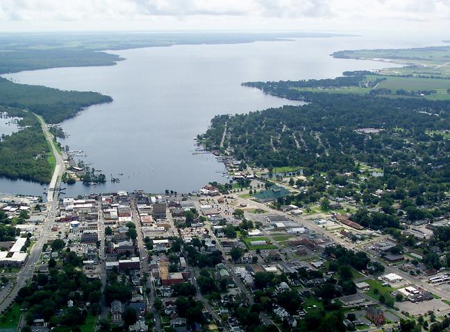


Elizabeth City, North Carolina
Elizabeth City is a city of 18,871 people in Camden County, North Carolina, founded in 1794.
Why visit Elizabeth City
Townapedia lists 16 museums and landmarks, 22 parks and trails, 58 places to eat, 16 places to stay and 4 attractions in and around town.
Highlights include RCE Theaters Elizabeth City, Camden County Courthouse and Camden County Jail.
July is the warmest month, with average highs of 89°F; January lows average 34°F.
Weather in Elizabeth City
Forecast from the National Weather Service. Full forecast
About Elizabeth City
Elizabeth City is a city in Pasquotank County, North Carolina, United States. As of the 2020 census, it had a population of 18,629. Elizabeth City is the county seat and most populous city of Pasquotank County. It is the cultural, economic and educational hub of the sixteen-county Historic Albemarle region of northeastern North Carolina.
From the Wikipedia article Elizabeth City, North Carolina (this version), under CC BY-SA 4.0.
Things to do4

College of The Albemarle – Performing Arts Center
Cinema and theater · 2.3 mi
1208 North Road Street, Elizabeth City
R/C Albemarle Movies 8
Cinema and theater · 1.2 mi
1805 City Center Blvd., Elizabeth City
Museums and landmarks16

Camden County Courthouse
Monument and historic site · National Register of Historic Places · 4.5 mi
Courthouse in North Carolina, United States

Camden County Jail
Monument and historic site · National Register of Historic Places · 4.3 mi
Prison in Camden, United States of America
Elizabeth City Historic District
Monument and historic site · National Register of Historic Places · 0.9 mi
Historic district in Elizabeth City, North Carolina
Elizabeth City State Teachers College Historic District
Monument and historic site · National Register of Historic Places · 1.6 mi
Campus in Elizabeth City, North Carolina
Elizabeth City Water Plant
Monument and historic site · National Register of Historic Places · 1.5 mi
Historic water plant in North Carolina, US
Episcopal Cemetery
Monument and historic site · National Register of Historic Places · 1.0 mi
Historic district in North Carolina, United States
Lamb-Ferebee House
Monument and historic site · National Register of Historic Places · 4.6 mi
Historic house in North Carolina, United States

Milford
Monument and historic site · National Register of Historic Places · 4.7 mi
Historic house near Camden, North Carolina, United States of America


Museum of the Albemarle
Museum · 1.0 mi
History museum
501 South Water Street, Elizabeth City
Mo-Sa 09:00-17:00
Norfolk Southern Passenger Station
Monument and historic site · National Register of Historic Places · 0.6 mi
Railway station in North Carolina, the United States of America
Northside Historic District
Monument and historic site · National Register of Historic Places · 1.3 mi
Historic district in North Carolina, United States
Old Brick House
Monument and historic site · National Register of Historic Places · 2.9 mi
House in Pasquotank County, North Carolina
4 more on the map.
Parks, trails and playgrounds22

Causeway Park
Park · 1.7 mi
Park along the Camden Causeway that has a boardwalk, which winds through the wetlands along the Pasquotank River. It has several...
Chalk Street Tot Lot
Park · 0.5 mi
Located between Chalk and Baxter Streets, on the Corners of Chalk and Grove Streets. This park, designed for small children, has shade...
George Wood Park
Park · 1.7 mi
Dedicated in memory of Mr. George Wood, a life-long resident of Camden County, this park has an elevated boardwalk that conects to two...
Gosnold Park
Park · 1.0 mi
This park, located on Gosnold Avenue, is sometimes called Sunset Park and consists of approximately three acres with playground...
Veteran's Park
Park · 1.2 mi
Located on North Water Street, next to the Pasquotank/Camden Bridge, this park was developed as a memorial in honor of all United States...


10 more on the map.
Restaurants and cafes58

IHOP
Restaurant · Breakfast, Pancake · 0.9 mi
1700 City Center Boulevard, Elizabeth City
Mo-Th,Su 06:00-22:00; Fr,Sa 06:00-23:00
Plaza Azteca Mexican Restaurant · Elizabeth City
Restaurant · Mexican · 3.1 mi
3870 Patrick Way
Mo-Fr 11:00-22:00; Sa 11:00-23:00; Su 11:00-21:00

Tony's Ristorante Italiano & Pizzeria
Restaurant · Burger, Italian, Pasta, Pizza · 0.7 mi
100 Alexander Court, Elizabeth City
Tu 11:00-19:30; We-Fr 11:00-20:30; Sa 16:00-20:30

2 Souls Wine Bar
Bar and pub · 1.1 mi
512 East Main Street, Elizabeth City
Mo-Th 16:00-21:00, Fr 16:00-22:00, Sa 14:00-22:00, Su 23:00-13:00
Cypress Creek Grill
Restaurant · 1.1 mi
113 South Water Street, Elizabeth City
Mo-Fr 11:00-21:00; Sa 17:00-21:00
Elizabeth City Pizza co.
Restaurant · 1.1 mi
507 East Main Street, Elizabeth City
Mo-Th 11:00-20:00; Fr,Sa 11:00-20:30; Su 12:00-19:00
Hoppin' Johnz
Restaurant · 1.2 mi
606 East Colonial Avenue, Elizabeth City
Mo-Su 11:30-21:00
46 more on the map.
History
Located at the narrows of the Pasquotank River, colonists used the area that developed as Elizabeth City as a trading site. As early as the mid 18th century, they established inspection stations and ferries. With the addition of minor roads, a schoolhouse, and soon a church, a small community developed at these narrows.
In 1793, businessmen supported construction of the Dismal Swamp Canal; it was integral to the success of Elizabeth City's commerce. The North Carolina Assembly incorporated the town as "Redding", renaming it in 1794 as "Elizabethtown". Due to resulting confusion with another town of the same name, in 1801, the city was renamed as "Elizabeth City". The name "Elizabeth" has been attributed to Elizabeth "Betsy" Tooley, a local tavern proprietress who donated much of the land for the new town.
With improvements to the Dismal Swamp Canal, commerce flourished and Elizabeth City became a financial center of trade and commercially successful in the early 19th century. In 1826, the federal government purchased 600 stocks in the canal and, in 1829, additional funds for improvements were raised by the Norfolk lottery. With these funds, the Dismal Swamp Canal was widened and deepened, allowing for larger boats to ship their goods to and from the city.
From the History section of Elizabeth City, North Carolina on Wikipedia, under CC BY-SA 4.0.
Where to stay16
Comfort Inn Elizabeth City Near University
Motel and hotel · 0.4 mi
306 S. Hughes Boulevard, Elizabeth City
Days Inn by Wyndham Elizabeth City
Motel and hotel · 0.4 mi
308 South Hughes Boulevard, Elizabeth City
Fairfield Inn & Suites Elizabeth City
Motel and hotel · 0.8 mi
1640 City Center Boulevard, Elizabeth City
Blue Ruby at Grice-Fearing House Bed and Breakfast
Motel and hotel · 0.9 mi
200 South Road Street, Elizabeth City
Foreman House Bed and Breakfast
Motel and hotel · 0.7 mi
311 West Church Street, Elizabeth City
Philemon House Bed & Breakfast
Motel and hotel · 0.8 mi
613 Maple Street, Elizabeth City
Quality Inn Elizabeth City Near University
Motel and hotel · 0.5 mi
522 South Hughes Boulevard, Elizabeth City
Queen Elizabeth Motel
Motel and hotel · 2.3 mi
1160 US Highway 17 South, Elizabeth City
Churches and places of worship34
Kingdom Hall of Jehovah’s Witnesses
Church · Jehovahs Witness · 0.4 mi
313 Shirley Street, Elizabeth City
Cann Memorial Presbyterian Church
Church · Presbyterian · 0.8 mi
311 West Main Street, Elizabeth City
Center Hill Baptist Church
Church · Baptist · 0.9 mi
611 South Martin Street, Elizabeth City
Christ Episcopal Church
Church · Episcopal · 1.0 mi
200 South McMorrine Street, Elizabeth City
First Baptist Church
Church · Baptist · 0.8 mi
300 West Main Street, Elizabeth City
Memorial Missionary Baptist Church
Church · Baptist
704 Cardwell Street, Elizabeth City
Shopping14
Gas and EV charging3
Schools, colleges and libraries32
Elizabeth City Pasquotank Early College
School · 2.3 mi
1208 N Road St, Elizabeth City
Healthcare6
DaVita Albermarle Dialysis
Clinic and pharmacy · 2.5 mi
101 Davita Lane, Elizabeth City
Map of Elizabeth City
205 places. The map loads OpenStreetMap tiles when you open it.
Climate by month
Monthly table
| Month | High | Low | Rain | Snow |
|---|---|---|---|---|
| Jan | 53°F | 34°F | 3.6 in | 0.1 in |
| Feb | 56°F | 35°F | 3.3 in | 0.1 in |
| Mar | 63°F | 41°F | 4.2 in | 0.0 in |
| Apr | 72°F | 50°F | 3.5 in | 0.0 in |
| May | 79°F | 59°F | 4.1 in | 0.0 in |
| Jun | 86°F | 68°F | 4.5 in | 0.0 in |
| Jul | 89°F | 72°F | 5.9 in | 0.0 in |
| Aug | 87°F | 71°F | 5.9 in | 0.0 in |
| Sep | 82°F | 66°F | 5.3 in | 0.0 in |
| Oct | 74°F | 55°F | 3.7 in | 0.0 in |
| Nov | 64°F | 44°F | 3.4 in | 0.0 in |
| Dec | 56°F | 38°F | 3.9 in | 0.0 in |
U.S. Climate Normals 1991-2020 for Elizabeth City Hcn (2 mi away), NOAA NCEI.
People and cost of living
American Community Survey 5-year estimates, 2020-2024, U.S. Census Bureau. Estimates have margins of error, larger for small towns.
Disaster history
Camden County has had 19 federal disaster declarations since 2000, most often for hurricanes.
- 2026-01-24: Severe Winter Storm (Winter Storm)
- 2024-09-26: Hurricane Helene (Tropical Storm)
- 2024-08-06: Tropical Storm Debby (Tropical Storm)
- 2022-10-01: Hurricane Ian (Hurricane)
- 2020-08-02: Hurricane Isaias (Hurricane)
- 2020-03-25: Covid-19 Pandemic (Biological)
OpenFEMA disaster declarations summaries.
Getting there and nearby towns
Elizabeth City Coast Guard Air Station/Regional Airport (ECG) is the nearest airport with scheduled flights listed in OpenStreetMap, 4 miles away.
- Camden 4 mi northeast, about 7 min by car
- Winfall 13 mi southwest, about 22 min by car
- Moyock 15 mi north, about 24 min by car
- Hertford 15 mi southwest, about 24 min by car
- Coinjock 16 mi east, about 26 min by car
- Grandy 20 mi east, about 33 min by car
- Chesapeake 27 mi north, about 43 min by car
- Virginia Beach 35 mi north, about 57 min by car
- Norfolk 43 mi north, about 1 h 15 min by car
- Hampton 52 mi north, about 1 h 30 min by car
Drive times are estimates from straight-line distance, not routes.
Local news
Headlines from INDB, the NEMICO news database.
Reviews, tips and questions
Loading what members have shared...
Sources and licences
- NCES EDGE (Public domain): public schools
- NOAA NCEI U.S. Climate Normals 1991-2020 (Public domain): climate by month
- OpenFEMA (Public domain): disaster declarations
- OpenStreetMap contributors (ODbL 1.0): places, airports, map data
- U.S. Census Bureau (Public domain): population, income, housing, education, commute
- Wikidata (CC0 1.0): elevation, founding date, time zone, website, landmarks and historic places
- Wikimedia Commons (see each image): photos
- Wikipedia (CC BY-SA 4.0): overview and history text
Photo credits
- Ec birdview, Unknown author, Public domain
- Norfolk Southern Passenger Station, Elizabeth City, Nyttend, Public domain
- Elizabeth City Episcopal Cemetery, Nyttend, Public domain
- Greetings from Elizabeth City, North Carolina - Large Letter Postcard (5621708700), Steve Shook from Moscow, Idaho, USA, CC BY 2.0
- Road south of Queen, Elizabeth City, Nyttend, Public domain
- Elizabeth City Water Plant, Nyttend, Public domain
- 1116 Riverside Avenue, Elizabeth City, Nyttend, Public domain
- Milford house, Jcl73, CC BY-SA 3.0
- Camden County Jail and museum, Nyttend, Public domain
- Museum of the Albemarle, Elizabeth City, NC, Ajsanjua, CC BY-SA 3.0
- Ecsucomplex, Uncsop, CC BY-SA 3.0
- RD and Senators Tillis and Budd Breakground Northeast Academy for Aerospace and Advanced Technologies Expansion (20241008-USDA-RD-NC-REK-0010), USDAgov, Public domain
- RD and Senators Tillis and Budd Breakground Northeast Academy for Aerospace and Advanced Technologies Expansion (20241008-USDA-RD-NC-REK-0007), USDAgov, Public domain
- RD and Senators Tillis and Budd Breakground Northeast Academy for Aerospace and Advanced Technologies Expansion (20241008-USDA-RD-NC-REK-0004), USDAgov, Public domain
- RD and Senators Tillis and Budd Breakground Northeast Academy for Aerospace and Advanced Technologies Expansion (20241008-USDA-RD-NC-REK-0008), USDAgov, Public domain
- RD and Senators Tillis and Budd Breakground Northeast Academy for Aerospace and Advanced Technologies Expansion (20241008-USDA-RD-NC-REK-0001), USDAgov, Public domain
- RD and Senators Tillis and Budd Breakground Northeast Academy for Aerospace and Advanced Technologies Expansion (20241008-USDA-RD-NC-REK-0002), USDAgov, Public domain
- Shepard Street Community Center, Nyttend, Public domain
- ElizabethCityNCMainStreet (cropped), Tyler Newman, CC BY-SA 4.0
- ElizabethCityNCMainStreet, Tyler Newman, CC BY-SA 4.0
- Lane Hall, ECSU, Nyttend, Public domain
- ISS030-E-97056 - View of Earth, Earth Science and Remote Sensing Unit , Lyndon B. Johnson Space Center, Public domain
- ISS030-E-95522 - View of Earth, Earth Science and Remote Sensing Unit , Lyndon B. Johnson Space Center, Public domain
- ISS030-E-97055 - View of Earth, Earth Science and Remote Sensing Unit , Lyndon B. Johnson Space Center, Public domain
- ISS066-E-192668 - View of Earth, Earth Science and Remote Sensing Unit , Lyndon B. Johnson Space Center, Public domain
- ISS030-E-95521 - View of Earth, Earth Science and Remote Sensing Unit , Lyndon B. Johnson Space Center, Public domain
- ISS066-E-192667 - View of Earth, Earth Science and Remote Sensing Unit , Lyndon B. Johnson Space Center, Public domain
- Winter Wonderland - Flickr - smkybear, Wendy, CC BY-SA 2.0
- The Old Brick House (c1750), Harvey Harrison, CC BY-SA 3.0


Page built October 30, 2026. Spotted a mistake? Tell us or suggest a place.