


Emigsville, Pennsylvania
Emigsville is a community of 4,254 people in York County, Pennsylvania.
Why visit Emigsville
Townapedia lists 18 museums and landmarks, 3 parks and trails, 1 place to stay and 1 attraction in and around town.
Highlights include Belmont Theatre, Barnett Bobb House, Billmeyer House and John Rudy Park.
July is the warmest month, with average highs of 88°F; January lows average 21°F, and about 25 inches of snow fall in a normal year.
Weather in Emigsville
Forecast from the National Weather Service. Full forecast
About Emigsville
Emigsville is a census-designated place (CDP) in York County, Pennsylvania, United States. The population was 3,563 at the 2020 census.
From the Wikipedia article Emigsville, Pennsylvania (this version), under CC BY-SA 4.0.
Things to do1

Belmont Theatre
Cinema and theater · 3.0 mi
Theater and former cinema in York, Pennsylvania
Museums and landmarks18

Barnett Bobb House
Monument and historic site · National Register of Historic Places · 3.3 mi
Historic house in Pennsylvania, United States

Billmeyer House
Monument and historic site · National Register of Historic Places · 3.1 mi
Historic home located in York, York County, Pennsylvania

Diamond Silk Mill
Monument and historic site · National Register of Historic Places · 2.6 mi
Historic mill in York County, Pennsylvania, U.S.

East York Historic District
Monument and historic site · National Register of Historic Places · 3.1 mi
Historic district in Pennsylvania, United States

Emig Mansion
Monument and historic site · National Register of Historic Places · 0.8 mi
Building in Pennsylvania, United States

Fairmount Historic District
Monument and historic site · National Register of Historic Places · 3.0 mi
Historic district in Pennsylvania, United States

Forry House
Monument and historic site · National Register of Historic Places · 3.3 mi
Historic house in Pennsylvania, United States
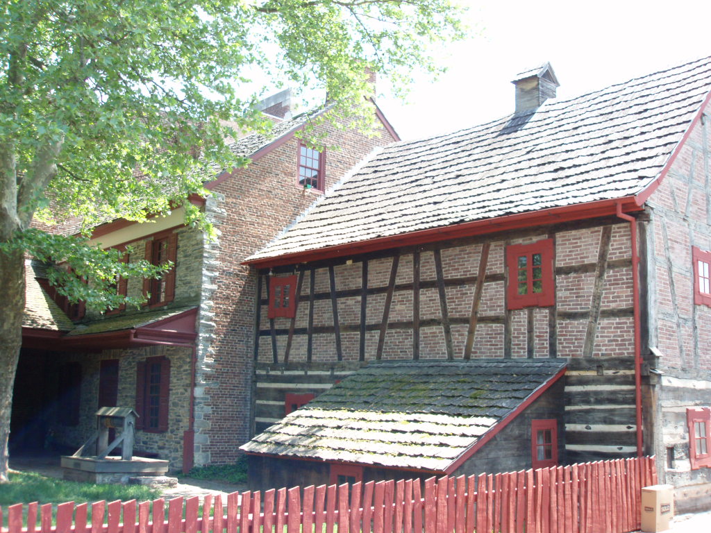
Golden Plough Tavern
Monument and historic site · National Register of Historic Places · 3.3 mi
Historic tavern in Pennsylvania, United States

Laurel–Rex Fire Company House
Monument and historic site · National Register of Historic Places · 3.3 mi
Fire station in Pennsylvania, United States of America
Michael and Magdealena Bixler Farmstead
Monument and historic site · National Register of Historic Places · 1.3 mi
Building in East Manchester Township, United States of America
Pleasureville Historic District
Monument and historic site · National Register of Historic Places · 1.2 mi
Historic district in Pennsylvania, United States


Sinking Springs Farms
Monument and historic site · National Register of Historic Places · 0.9 mi
Historic farm and historic district in York County, Pennsylvania
6 more on the map.
Parks, trails and playgrounds3

Where to stay1

History
The Emig Mansion was listed on the National Register of Historic Places in 1984.
Emigsville is home to the Emigsville Band, formerly known as the Acme Cornet Band of Emigsville, PA. The organization traces its roots to 1872 when it was founded as a company band for the Acme Wagon Works Company. The band owns its Band Hall located at 3175 North George Street. It is one of a few remaining community concert bands in the county.
From the History section of Emigsville, Pennsylvania on Wikipedia, under CC BY-SA 4.0.
Churches and places of worship7
York Meetinghouse
Church · National Register of Historic Places · 3.4 mi
Saint John Chrysostom Antiochian Orthodox Church
Church · Orthodox · 1.3 mi
2397 North Sherman Street, York
Pleasureville United Methodist
Church · Methodist · 1.2 mi
2606 North Sherman Street, York
Stillmeadow Church of the Nazarene
Church · Christian · 1.5 mi
400 Stillmeadow Lane, York
Gas and EV charging1
Schools, colleges and libraries43
Map of Emigsville
74 places. The map loads OpenStreetMap tiles when you open it.
Climate by month
Monthly table
| Month | High | Low | Rain | Snow |
|---|---|---|---|---|
| Jan | 41°F | 21°F | 3.3 in | 8.5 in |
| Feb | 45°F | 23°F | 2.8 in | 8.2 in |
| Mar | 54°F | 30°F | 4.0 in | 3.9 in |
| Apr | 67°F | 40°F | 3.6 in | 0.2 in |
| May | 76°F | 50°F | 4.2 in | 0.0 in |
| Jun | 84°F | 58°F | 4.3 in | 0.0 in |
| Jul | 88°F | 63°F | 4.5 in | 0.0 in |
| Aug | 86°F | 62°F | 4.0 in | 0.0 in |
| Sep | 80°F | 54°F | 5.1 in | 0.0 in |
| Oct | 68°F | 43°F | 3.9 in | 0.0 in |
| Nov | 56°F | 33°F | 3.2 in | 0.5 in |
| Dec | 45°F | 26°F | 3.5 in | 3.3 in |
U.S. Climate Normals 1991-2020 for York 3 Ssw Pump Stn Hcn (7 mi away), NOAA NCEI.
People and cost of living
American Community Survey 5-year estimates, 2020-2024, U.S. Census Bureau. Estimates have margins of error, larger for small towns.
Disaster history
York County has had 13 federal disaster declarations since 2000, most often for hurricanes.
- 2021-09-10: Remnants Of Hurricane Ida (Hurricane)
- 2020-03-30: Covid-19 Pandemic (Biological)
- 2020-03-13: Covid-19 (Biological)
- 2016-03-23: Severe Winter Storm And Snowstorm (Snowstorm)
- 2014-02-06: Severe Winter Storm (Severe Ice Storm)
- 2012-10-29: Hurricane Sandy (Hurricane)
OpenFEMA disaster declarations summaries.
Getting there and nearby towns
York Airport (THV) is the nearest airport with scheduled flights listed in OpenStreetMap, 10 miles away.
- York 3 mi south, about 5 min by car
- Mount Wolf 4 mi north, about 6 min by car
- Shiloh 4 mi southwest, about 7 min by car
- Yorklyn 4 mi east, about 7 min by car
- Queens Gate 5 mi south, about 8 min by car
- Weigelstown 6 mi west, about 9 min by car
- Dover 7 mi west, about 11 min by car
- Bainbridge 7 mi northeast, about 11 min by car
- New Salem 8 mi southwest, about 13 min by car
- Dallastown 9 mi southeast, about 14 min by car
Drive times are estimates from straight-line distance, not routes.
Local news
Headlines from INDB, the NEMICO news database.
Reviews, tips and questions
Loading what members have shared...
Sources and licences
- NCES EDGE (Public domain): public schools
- NOAA NCEI U.S. Climate Normals 1991-2020 (Public domain): climate by month
- OpenFEMA (Public domain): disaster declarations
- OpenStreetMap contributors (ODbL 1.0): places, airports, map data
- U.S. Census Bureau (Public domain): population, income, housing, education, commute
- Wikidata (CC0 1.0): elevation, founding date, time zone, website, landmarks and historic places
- Wikimedia Commons (see each image): photos
- Wikipedia (CC BY-SA 4.0): overview and history text
Photo credits
- Emig House 1 YorkCo PA, Smallbones, CC0
- PA 181 nb in Emigsville (1), Feb. 2026, Mr. Matté (if there is an issue with this image, contact me using this image's Commons talk page , my Commons user talk page , or my English Wikipedia user talk page ; I'll know about it a lot faster), CC BY-SA 4.0
- PA 181 nb entering Emigsville, Feb. 2026, Mr. Matté (if there is an issue with this image, contact me using this image's Commons talk page , my Commons user talk page , or my English Wikipedia user talk page ; I'll know about it a lot faster), CC BY-SA 4.0
- PA 181 nb in Emigsville (2), Feb. 2026, Mr. Matté (if there is an issue with this image, contact me using this image's Commons talk page , my Commons user talk page , or my English Wikipedia user talk page ; I'll know about it a lot faster), CC BY-SA 4.0
- Diamond Silk Mill YorkCo PA, Smallbones, CC0
- York Meeting WSW, Smallbones, Public domain
- York Dispatch, Smallbones, Public domain
- Laurel Rex FD York PA, Smallbones, Public domain
- York Fairmount HD 113-15 Stevens, Smallbones, CC0
- Central Market York PA, Smallbones, Public domain
- Pennsylvania - York Armory - 20190904171932, Photoing Dragon, CC BY-SA 4.0
- Billmeyer House, Paul Galbreath, Public domain
- Willis House, Paul Galbreath, Public domain
- Barnett Bobb House York PA, Smallbones, Public domain
- SINKING SPRINGS FARM, YORK COUNTY, PA, JERRYE & ROY KLOTZ, M.D., CC BY-SA 4.0
- Forry House 1809, Smallbones, Public domain
- School Adams St West York PA, Smallbones, CC0
- YorkPaGPTavern, Adavidb, Public domain
- 34 Manheim East York YorkCo PA, Smallbones, CC0
- United Cigar York PA, Smallbones, Public domain
- PA 181 nb in Hayshire, Feb. 2026, Mr. Matté (if there is an issue with this image, contact me using this image's Commons talk page , my Commons user talk page , or my English Wikipedia user talk page ; I'll know about it a lot faster), CC BY-SA 4.0
- Emig House 3 YorkCo PA, Smallbones, CC0
- Emig House 2 YorkCo PA, Smallbones, CC0
- PA 181 nb approaching PA 238, Feb. 2026, Mr. Matté (if there is an issue with this image, contact me using this image's Commons talk page , my Commons user talk page , or my English Wikipedia user talk page ; I'll know about it a lot faster), CC BY-SA 4.0
- PA 238 wb from PA 181, Feb. 2026, Mr. Matté (if there is an issue with this image, contact me using this image's Commons talk page , my Commons user talk page , or my English Wikipedia user talk page ; I'll know about it a lot faster), CC BY-SA 4.0
- Houses along PA 181, Woodland View, Feb. 2026, Mr. Matté (if there is an issue with this image, contact me using this image's Commons talk page , my Commons user talk page , or my English Wikipedia user talk page ; I'll know about it a lot faster), CC BY-SA 4.0
- I-83 (PA) sb approaching exit 22, July 2025, Mr. Matté (if there is an issue with this image, contact me using this image's Commons talk page , my Commons user talk page , or my English Wikipedia user talk page ; I'll know about it a lot faster), CC BY-SA 4.0
- Pennsylvania State Route 181 - 4171033675, Dougtone, CC BY-SA 2.0
- Pleasureville YorkCo PA Historic District, Smallbones, CC0
- Bixler House YorkCo PA 5, Smallbones, CC0
- Bixler House YorkCo PA 6, Smallbones, CC0
- Bixler House YorkCo PA 4, Smallbones, CC0
- Bixler House YorkCo PA 1, Smallbones, CC0
- Bixler House YorkCo PA 3, Smallbones, CC0
- Bixler House YorkCo PA 2, Smallbones, CC0
- Pennsylvania State Route 181 - 4171033069, Dougtone, CC BY-SA 2.0
- ISS066-E-139570 - View of Earth, Earth Science and Remote Sensing Unit , Lyndon B. Johnson Space Center, Public domain
- ISS028-E-33952 - View of Earth, Earth Science and Remote Sensing Unit , Lyndon B. Johnson Space Center, Public domain
- ISS062-E-118168 - View of Earth, Earth Science and Remote Sensing Unit, NASA Johnson Space Center, Public domain
- ISS062-E-67348 - View of Earth, Earth Science and Remote Sensing Unit, NASA Johnson Space Center, Public domain


Page built October 30, 2026. Spotted a mistake? Tell us or suggest a place.