

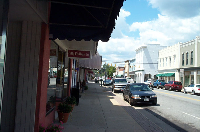


Emporia, Virginia
Emporia is a city of 5,547 people in Emporia city, Virginia, founded in 1967.
Why visit Emporia
Townapedia lists 10 museums and landmarks, 3 parks and trails, 30 places to eat and 9 places to stay in and around town.
Highlights include Belfield-Emporia Historic District, Franklin Historic District, Meherrin River Park Complex and Veterans Memorial Park.
July is the warmest month, with average highs of 90°F; January lows average 29°F.
Weather in Emporia
Forecast from the National Weather Service. Full forecast
About Emporia
Emporia is an independent city in the Commonwealth of Virginia in the United States. It is the county seat of Greensville County. As of the 2020 census, the population was 5,766, making it the third-least populous city in Virginia. The Bureau of Economic Analysis combines the city of Emporia with surrounding Greensville County for statistical purposes.
From the Wikipedia article Emporia, Virginia (this version), under CC BY-SA 4.0.
Museums and landmarks10

Belfield-Emporia Historic District
Monument and historic site · National Register of Historic Places
Historic district in Emporia, Virginia
Franklin Historic District
Monument and historic site · National Register of Historic Places
Historic district in Virginia, USA
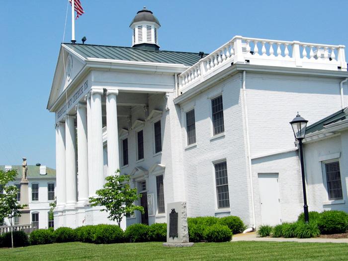
Greensville County Courthouse Complex
Monument and historic site · National Register of Historic Places · 0.8 mi
Courthouse in Emporia, United States of America

Greensville County Training School
Monument and historic site · National Register of Historic Places
School building in Emporia, Virginia, United States of America

H. T. Klugel Architectural Sheet Metal Work Building
Monument and historic site · National Register of Historic Places
Historic factory building in Virginia, US

Hicksford-Emporia Historic District
Monument and historic site · National Register of Historic Places · 0.8 mi
Historic district in Virginia, United States

Old Merchants and Farmers Bank Building
Monument and historic site · National Register of Historic Places · 0.9 mi
Historic commercial building in Virginia, United States

Village View
Monument and historic site · National Register of Historic Places · 1.1 mi
Historic house in Virginia, United States


Washington Avenue Historic District
Monument and historic site · National Register of Historic Places
Listed on the NRHP in Virginia

Parks, trails and playgrounds3

Restaurants and cafes30

Cracker Barrel
Diner · American · 0.5 mi
103 Sadler Lane, Emporia
Su-Th 07:00-21:00; Fr-Sa 07:00-22:00

Fo Sho Italian Sports Bar & Grille
Restaurant · Italian · 1.1 mi
916 West Atlantic Street, Emporia
Mo-Sa 11:00-22:00
Pizza Hut
Restaurant · Pizza · 0.9 mi
301 Market Drive, Emporia
Mo-Th, Su 11:00-22:00; Fr, Sa 11:00-23:00

Starbucks
Cafe · Coffee Shop · 0.6 mi
105 East Cloverleaf Drive, Emporia
Mo-Th 05:30-20:30; Fr-Su 05:30-21:00
El Ranchero
Restaurant · Mexican · 1.1 mi
921 West Atlantic Street, Emporia
Mo-Sa 11:00-22:00; Su 11:30-21:00
Logan's Diner
Diner · American · 0.8 mi
414 South Main Street, Emporia
Mo-Sa 06:00-14:00
Pino's Italian Restaurant
Restaurant · Italian · 1.1 mi
923 West Atlantic Street, Emporia
Mo-Su 11:00-21:30
Wong's Garden
Restaurant · Chinese · 0.9 mi
301 Market Drive, Emporia
Mo-Th 11:00-21:30; Fr-Sa 11:00-22:00; Su off
Fork In The Road
Restaurant · 0.8 mi
334 South Main Street, Emporia
The Bank: Inspired By Lucy & Linda
Restaurant · Southern · 0.8 mi
401 South Main Street, Emporia

18 more on the map.
Where to stay9

History
Emporia has long been a transportation crossroads. The Meherrin River, like the Nottoway River and the Blackwater River, empties to the southeast into Albemarle Sound. The Town of Hicksford (originally Hicks' Ford) was settled by Captain Robert Hicks (1658–1739) in the Virginia Colony, where the east-west Fort Road of eastern Virginia crossed the Meherrin River en route to Fort Christanna. The other crossing road was a major north–south trail used by native peoples and sometimes called the "Tuscarora Path" and later became the "Halifax road".
Captain Hicks was an Indian trader who had lived in Prince George County before moving his family to Hicksford, when he became the Commander of Fort Christanna. (His surname is spelled both "Hicks" and "Hix" in colonial records.) In 1709, Hicks purchased a land tract of 1,280 acres (520 ha) along the north side of the Meherrin River that was previously surveyed by Arthur Kavanaugh.
When Greensville County separated from Brunswick County in 1781, Hicksford became the county seat. (Court convened monthly at a nearby tavern). In May 1781, British Col. Banastre Tarleton's cavalry crossed at Hicksford while raiding Greensville and Southampton counties.
After statehood, the Virginia General Assembly recognized the Town of Belfield on the river's northern bank in 1798, and Hicksford on the southern bank the next year.
From the History section of Emporia, Virginia on Wikipedia, under CC BY-SA 4.0.
Churches and places of worship30
Main Street United Methodist Church
Church · Methodist · 1.0 mi
105 Church Street, Emporia
Greens Chapel Number Two Reformed Zion Union Apostolic Church
Church · Reformed · 0.4 mi
Shopping4
Gas and EV charging20
Schools, colleges and libraries14
Healthcare5
Map of Emporia
125 places. The map loads OpenStreetMap tiles when you open it.
Climate by month
Monthly table
| Month | High | Low | Rain | Snow |
|---|---|---|---|---|
| Jan | 51°F | 29°F | 3.4 in | 0.6 in |
| Feb | 54°F | 30°F | 2.6 in | 0.3 in |
| Mar | 62°F | 37°F | 4.0 in | 0.0 in |
| Apr | 72°F | 46°F | 3.4 in | 0.0 in |
| May | 79°F | 56°F | 3.7 in | 0.0 in |
| Jun | 86°F | 65°F | 4.0 in | 0.0 in |
| Jul | 90°F | 69°F | 4.9 in | 0.0 in |
| Aug | 88°F | 68°F | 5.1 in | 0.0 in |
| Sep | 83°F | 62°F | 4.9 in | 0.0 in |
| Oct | 73°F | 49°F | 3.5 in | 0.0 in |
| Nov | 63°F | 38°F | 3.2 in | 0.0 in |
| Dec | 54°F | 32°F | 3.6 in | 0.5 in |
U.S. Climate Normals 1991-2020 for Emporia 1 Wnw (1 mi away), NOAA NCEI.
People and cost of living
American Community Survey 5-year estimates, 2020-2024, U.S. Census Bureau. Estimates have margins of error, larger for small towns.
Disaster history
Emporia city has had 10 federal disaster declarations since 2000, most often for hurricanes.
- 2026-01-23: Severe Winter Storm (Winter Storm)
- 2020-04-02: Covid-19 Pandemic (Biological)
- 2020-03-13: Covid-19 (Biological)
- 2018-09-11: Hurricane Florence (Hurricane)
- 2012-10-29: Hurricane Sandy (Hurricane)
- 2011-09-03: Hurricane Irene (Hurricane)
OpenFEMA disaster declarations summaries.
Getting there and nearby towns
Lawrenceville-Brunswick Municipal Airport (LVL) is the nearest airport with scheduled flights listed in OpenStreetMap, 16 miles away.
- Roanoke Rapids 18 mi south, about 30 min by car
- South Rosemary 19 mi southwest, about 31 min by car
- Weldon 19 mi south, about 31 min by car
- Courtland 26 mi east, about 42 min by car
- Murfreesboro 30 mi southeast, about 48 min by car
- Bracey 33 mi west, about 53 min by car
- Petersburg 36 mi north, about 58 min by car
- Enfield 36 mi south, about 59 min by car
- Blackstone 37 mi northwest, about 1 h by car
- Colonial Heights 40 mi north, about 1 h by car
Drive times are estimates from straight-line distance, not routes.
Local news
Headlines from INDB, the NEMICO news database.
Reviews, tips and questions
Loading what members have shared...
Sources and licences
- NCES EDGE (Public domain): public schools
- NOAA NCEI U.S. Climate Normals 1991-2020 (Public domain): climate by month
- OpenFEMA (Public domain): disaster declarations
- OpenStreetMap contributors (ODbL 1.0): places, airports, map data
- U.S. Census Bureau (Public domain): population, income, housing, education, commute
- Wikidata (CC0 1.0): elevation, founding date, time zone, website, landmarks and historic places
- Wikimedia Commons (see each image): photos
- Wikipedia (CC BY-SA 4.0): overview and history text
Photo credits
- Emporia10, Corvokarasu at English Wikipedia, Public domain
- Franklin, Virginia, Taber Andrew Bain (user:taberandrew), CC BY 2.0
- HT Klugel Building from US 58 Business, DanTD, CC BY-SA 4.0
- Emporia, Virginia First National Bank, DanTD, CC BY-SA 3.0
- Hugh Mercer Statue With Houses in Background 1300 Block Washington Avenue Historic District Frederickburg VA, Justinandsarah, Public domain
- Emporia, Virginia Masonic Lodge, DanTD, CC BY-SA 4.0
- Greensville Training Center Restoration-1, DanTD, CC BY-SA 4.0
- Old Merchants and Farmers Bank Building (Emporia, VA), DanTD, CC BY-SA 4.0
- Greensville Emporia Courthouse, Taber Andrew Bain, CC BY 2.0
- Village View (The Mansion) in Emporia, Virginia, DanTD, CC BY-SA 4.0
Page built October 30, 2026. Spotted a mistake? Tell us or suggest a place.