


Enid, Oklahoma
Enid is a city of 50,653 people in Garfield County, Oklahoma, founded in 1893.
Why visit Enid
Townapedia lists 31 museums and landmarks, 36 parks and trails, 43 places to eat, 8 places to stay and 4 attractions in and around town.
Highlights include Gaslight Theatre, Phillips University, Railroad Museum of Oklahoma and Broadway Tower.
July is the warmest month, with average highs of 95°F; January lows average 25°F.
Weather in Enid
Forecast from the National Weather Service. Full forecast
About Enid
Enid is the ninth-largest city in the U.S. state of Oklahoma. It is the county seat of Garfield County. In the 2020 census, the population was 51,308. Enid was founded during the opening of the Cherokee Outlet in the Land Run of 1893, and is named after Enid, a character in Alfred, Lord Tennyson's Idylls of the King.
From the Wikipedia article Enid, Oklahoma (this version), under CC BY-SA 4.0.
Things to do4
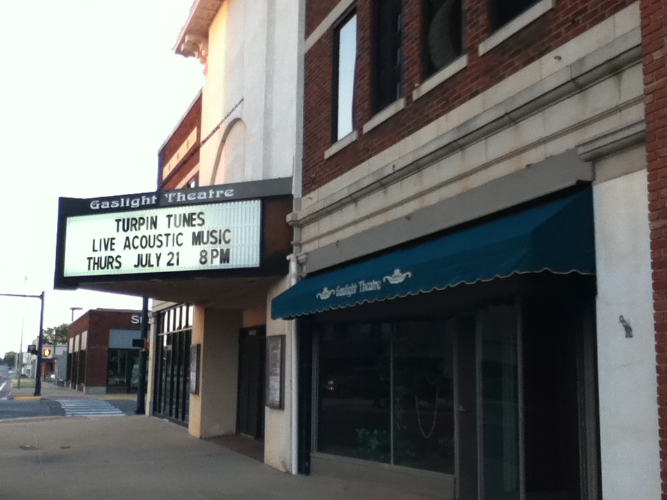
Gaslight Theatre
Cinema and theater · 0.8 mi
Theater company and theater in Enid, Oklahoma, United States, a former movie theater

Phillips University
School · 1.6 mi
American a private liberal arts institution in Enid, Oklahoma USA

Museums and landmarks31

Railroad Museum of Oklahoma
Museum · National Register of Historic Places · 0.7 mi
Railroad museum in Enid, Oklahoma, United States
702 North Washington Street, Enid

Broadway Tower
Monument and historic site · National Register of Historic Places · 0.8 mi
Building in Enid, Oklahoma, USA

Clay Hall
Monument and historic site · National Register of Historic Places · 1.6 mi
Building in Oklahoma

Enid Armory
Monument and historic site · National Register of Historic Places · 0.5 mi
Armory in Oklahoma, United States of America

Enid Cemetery
Monument and historic site · National Register of Historic Places · 1.2 mi
Cemetery in Enid, Oklahoma

Enid Downtown Historic District
Monument and historic site · National Register of Historic Places · 0.9 mi
Historic district in Oklahoma, United States

Enid Masonic Temple
Monument and historic site · National Register of Historic Places · 1.0 mi
Masonic temple in Oklahoma, United States of America

Enid Terminal Grain Elevators Historic District
Monument and historic site · National Register of Historic Places · 1.3 mi
Historic district in Oklahoma, United States

Garfield County Courthouse
Monument and historic site · National Register of Historic Places · 0.8 mi
Courthouse in Oklahoma, United States

H. H. Champlin House
Monument and historic site · National Register of Historic Places · 1.7 mi
Historic house in Oklahoma, United States


Jackson School
Monument and historic site · National Register of Historic Places · 2.7 mi
School building in Enid, Oklahoma, United States

Kenwood Historic District
Monument and historic site · National Register of Historic Places · 0.9 mi
Historic district in Enid, Oklahoma
19 more on the map.
Parks, trails and playgrounds36



24 more on the map.
Restaurants and cafes43

7 Brew
Cafe · Coffee Shop · 3.4 mi
4010 West Owen K. Garriott Road, Enid
Su-Th 05:30-22:00; Fr-Sa 05:30-23:00

Bricktown Brewery
Restaurant · Burger, Sandwich, Pizza, Grill, Seafood, Chicken, Regional · 3.1 mi
3616 West Owen K. Garriott Road, Enid
Su-Th 11:00-21:00; Fr-Sa 11:00-22:00
Colton's Steak House & Grill
Restaurant · Steak House · 2.4 mi
707 South Cleveland Street, Enid
Su-Th 10:45-21:30; Fr-Sa 10:45-22:00
Wee Too
Restaurant · Breakfast · 1.9 mi
4002 North 4th Street, Enid
Mo-Su 06:00-14:00
Da Vinci's Coffeehouse and Gelateria Central
Cafe · Coffee Shop, Tea, Sandwich, Breakfast, Pastry · 2.3 mi
31 more on the map.
History
Prior to the Land Run of 1893, the land where present-day Enid, Oklahoma sits was part of O County in the Cherokee Outlet, and was occupied by the Cherokee people following the Treaty of New Echota and the Cherokee trail of tears. Historically, the area was a hunting ground for the Wichita, Osage, and Kiowa tribes. The Chisholm Trail, stage coach lines, mail routes, and railroads passed through stations in the town which was then known as Skeleton.
During the opening of the Cherokee Outlet in the Land Run of 1893, Enid was the location of a land office which is now preserved in its Humphrey Heritage Village, part of the Cherokee Strip Regional Heritage Center. Enid, the rail station, now North Enid, Oklahoma, was the original town site endorsed by the government. It was platted by the surveyor W. D. Twichell, then of Amarillo, Texas.
The Enid-Pond Creek Railroad War ensued when the Department of the Interior moved the government site 3 mi (5 km) south of the station prior to the land run, which was then called South Enid. During the run, due to the Rock Island's refusal to stop, people leaped from the trains to stake their claim in the government-endorsed site. By the afternoon of the run, Enid's population was estimated at 12,000 people, located in the Enid's 80-acre (320,000 m2) town plat.
From the History section of Enid, Oklahoma on Wikipedia, under CC BY-SA 4.0.
Where to stay8
Churches and places of worship62
Emmanuel Baptist Church
Church · Baptist · 2.5 mi
2505 West Owen K Garriott Road, Enid
First Assembly of God Church
Church · Pentecostal · 3.1 mi
905 North Oakwood Road, Enid
Saint Mathew's Episcopal Church
Church · Episcopal · 1.0 mi
518 West Randolph Avenue, Enid
The Church of Jesus Christ of Latter-day Saints
Church · Mormon · 2.9 mi
419 North Eisenhower Street, Enid
Shopping19
Gas and EV charging6
Schools, colleges and libraries50
Healthcare7
INTEGRIS Health Jim Thorpe Outpatient Rehabilitation Enid
Clinic and pharmacy · 1.0 mi
401 South 3rd Street, Enid
Map of Enid
250 places. The map loads OpenStreetMap tiles when you open it.
Climate by month
Monthly table
| Month | High | Low | Rain | Snow |
|---|---|---|---|---|
| Jan | 47°F | 25°F | 1.0 in | 2.4 in |
| Feb | 51°F | 28°F | 1.3 in | 2.0 in |
| Mar | 61°F | 37°F | 2.4 in | 1.5 in |
| Apr | 70°F | 46°F | 3.4 in | 0.0 in |
| May | 79°F | 58°F | 4.4 in | 0.0 in |
| Jun | 89°F | 67°F | 4.8 in | 0.0 in |
| Jul | 95°F | 72°F | 3.3 in | 0.0 in |
| Aug | 93°F | 70°F | 3.6 in | 0.0 in |
| Sep | 85°F | 62°F | 2.7 in | 0.0 in |
| Oct | 73°F | 49°F | 3.1 in | 0.0 in |
| Nov | 59°F | 37°F | 1.7 in | 0.4 in |
| Dec | 48°F | 28°F | 1.5 in | 3.1 in |
U.S. Climate Normals 1991-2020 for Enid Hcn (1 mi away), NOAA NCEI.
People and cost of living
American Community Survey 5-year estimates, 2020-2024, U.S. Census Bureau. Estimates have margins of error, larger for small towns.
Disaster history
Garfield County has had 21 federal disaster declarations since 2000, most often for severe storms.
- 2021-02-24: Severe Winter Storms (Severe Ice Storm)
- 2021-02-17: Severe Winter Storm (Severe Ice Storm)
- 2020-12-21: Severe Winter Storm (Severe Ice Storm)
- 2020-04-05: Covid-19 Pandemic (Biological)
- 2020-03-13: Covid-19 (Biological)
- 2019-06-01: Severe Storms, Straight-Line Winds, Tornadoes, And Flooding (Severe Storm)
OpenFEMA disaster declarations summaries.
Getting there and nearby towns
Vance Air Force Base (END) is the nearest airport with scheduled flights listed in OpenStreetMap, 5 miles away.
- North Enid 3 mi north, about 4 min by car
- Waukomis 9 mi south, about 14 min by car
- Drummond 12 mi southwest, about 19 min by car
- Lahoma 12 mi west, about 20 min by car
- Garber 16 mi east, about 26 min by car
- Pond Creek 18 mi north, about 30 min by car
- Hennessey 21 mi south, about 34 min by car
- Guthrie 45 mi southeast, about 1 h 15 min by car
- Stillwater 48 mi southeast, about 1 h 15 min by car
- Ponca City 49 mi northeast, about 1 h 15 min by car
Drive times are estimates from straight-line distance, not routes.
Local news
Headlines from INDB, the NEMICO news database.
Reviews, tips and questions
Loading what members have shared...
Sources and licences
- NCES EDGE (Public domain): public schools
- NOAA NCEI U.S. Climate Normals 1991-2020 (Public domain): climate by month
- OpenFEMA (Public domain): disaster declarations
- OpenStreetMap contributors (ODbL 1.0): places, airports, map data
- U.S. Census Bureau (Public domain): population, income, housing, education, commute
- Wikidata (CC0 1.0): elevation, founding date, time zone, website, landmarks and historic places
- Wikimedia Commons (see each image): photos
- Wikipedia (CC BY-SA 4.0): overview and history text
Photo credits
- East on Broadway, Drobinson, Public domain
- 2015-06-25 Enid, Oklahoma depot, joannapoe, CC BY-SA 2.0
- Harrison School, Enid OK, OKJaguar, CC BY-SA 4.0
- Enid Railroad museum and Santa Fe freight depot, Kiddo27, CC0
- Kenwood Historic District, Enid, OK, OKJaguar, CC BY-SA 4.0
- Cherokee Terrace Apartments, Enid, OK, OKJaguar, CC BY-SA 4.0
- Greetings from Enid, Oklahoma, "Where Wheat Grows and Oil Flows" - Large Letter Postcard (8150151781), Steve Shook from Moscow, Idaho, USA, CC BY 2.0
- Babe's Package Store, Enid, OK, OKJaguar, CC BY-SA 4.0
- Security National Bank, Enid, OK, OKJaguar, CC BY-SA 4.0
- Owen K. Garriott street in Enid, Oklahoma, Kiddo27, CC0
- Clay Hall, Enid, OK, OKJaguar, CC BY-SA 4.0
- Enid High School Observatory, Enid, OK, OKJaguar, CC BY-SA 4.0
- Dr. Nancy Currie-Gregg Observatory at Enid High School, Soonerson921, CC BY-SA 4.0
- Robert R. and Minnie L. Kisner House, Enid, OK, OKJaguar, CC BY-SA 4.0
- Geronimo Car by Enid Antique Auto Club 03, Kiddo27, CC0
- Geronimo Car by Enid Antique Auto Club 01, Kiddo27, CC0
- Geronimo Car by Enid Antique Auto Club 02, Kiddo27, CC0
- Description of Geronimo Car by Enid Antique Auto Club, Kiddo27, CC0
- Geronimo Car by Enid Antique Auto Club 04, Kiddo27, CC0
- Railroad Museum of Oklahoma, Matthew Zisi, CC BY-SA 4.0
- Public Library of Enid and Garfield County 03, Kiddo27, CC BY-SA 4.0
- Champlin Mansion Enid, Kiddo27, CC BY-SA 3.0
- Enid Cemetery Gate, Kiddo27, CC BY-SA 3.0
- TT Eason Mansion, Kiddo27, CC BY-SA 3.0
- Rock Island Depot (Enid, Oklahoma), Matthew Zisi, CC BY-SA 4.0
- SW View of Enid Armory, Shannon Helton, CC BY-SA 3.0
- Grain Storage, Drobinson, Public domain
- Enid Knox Building, Kiddo27, CC BY-SA 3.0
- Lamerton House, Kiddo27, CC BY-SA 3.0
- Clay Hall Enid, Kiddo27, CC BY-SA 3.0
- Downtown Enid, Oklahoma during Oktoberfest, Kiddo27, CC BY-SA 4.0
- Jackson School Enid, Kiddo27, CC BY-SA 3.0
- Enid Broadway Tower, Kiddo27, CC BY-SA 3.0
- Garfield County Courthouse front, Kiddo27, CC BY-SA 3.0
- Cherokeestripheritagecenter2, Kiddo27, CC BY-SA 3.0
- Midgley Museum, Kiddo27, CC BY-SA 3.0
- Phillips University Pillars, Doctorfree, Public domain
- Gaslight Theater Enid, Kiddo27, CC BY-SA 3.0
- Classic Jeep - panoramio, scooterjes, CC BY-SA 3.0
- Classic Mack Truck - panoramio, scooterjes, CC BY-SA 3.0


Page built October 30, 2026. Spotted a mistake? Tell us or suggest a place.