


Fargo, North Dakota
Fargo is a city of 131,627 people in Cass County, North Dakota, founded in 1871.
Why visit Fargo
Townapedia lists 60 museums and landmarks, 81 parks and trails, 231 places to eat, 51 places to stay and 11 attractions in and around town.
Highlights include Red River Zoo, West Acres Cinema, Plains Art Museum and Comstock House.
July is the warmest month, with average highs of 82°F; January lows average -2°F.
Weather in Fargo
Forecast from the National Weather Service. Full forecast
About Fargo
Fargo is the most populous city in the U.S. state of North Dakota. The population was 125,990 at the 2020 census and estimated at 136,285 in 2024. Fargo and its twin city of Moorhead, Minnesota, form the core of the Fargo–Moorhead metropolitan area, which had a population of 248,591 in 2020. It is the county seat of Cass County.
From the Wikipedia article Fargo, North Dakota (this version), under CC BY-SA 4.0.
Things to do11

Red River Zoo
Zoo and aquarium · 1.8 mi
Zoo in Fargo, North Dakota, USA
4255 23rd Avenue South, Fargo
Mo-Su 10:00-19:00


Fargo-Moorhead Toll Bridge
Bridge · 3.1 mi
Toll bridge over the Red River of the Horth bridging North Dakota and Minnesota

Minnesota State University Moorhead
School · 3.2 mi
University in Moorhead, Minnesota
North Dakota State University
School · 2.3 mi
Public university in Fargo, North Dakota

Museums and landmarks60

Plains Art Museum
Museum · 2.0 mi
Museum in Fargo, North Dakota
704 1st Avenue North, Fargo
Mo,We,Fr 11:00-17:00; Tu,Th 11:00-21:00; Sa 10:00-17:00; Su off
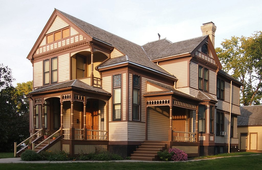
Comstock House
Monument and historic site · National Register of Historic Places · 2.9 mi
Historic house in Minnesota, United States

Downtown Fargo District
Monument and historic site · National Register of Historic Places · 2.1 mi
NRHP historic district in Fargo, North Dakota, U.S.A.


Fargo Oak Grove Residential Historic District
Monument and historic site · National Register of Historic Places · 2.8 mi
Historic district in North Dakota, United States
Fargo South Residential District
Monument and historic site · National Register of Historic Places · 1.8 mi
Historic district in North Dakota, United States

Fargo Theatre
Cinema and theater · National Register of Historic Places · 2.2 mi
Theater and movie theater in Fargo, North Dakota, U.S.A.
314 North Broadway Drive

M.E. Beebe Historic District
Monument and historic site · National Register of Historic Places · 2.0 mi
Historic district in Fargo, North Dakota, United States
North Dakota State University District
Monument and historic site · National Register of Historic Places · 2.4 mi
Historic district in Fargo, North Dakota, United States

North Side Fargo Builder's Residential Historic District
Monument and historic site · National Register of Historic Places · 2.9 mi
Historic district in North Dakota, United States


North Side Fargo High Style Residential Historic District
Monument and historic site · National Register of Historic Places · 2.6 mi
Historic district in North Dakota, United States
Barrington Apartments
Monument and historic site · National Register of Historic Places · 1.6 mi
Multifamily residential in Fargo, United States of America
48 more on the map.
Parks, trails and playgrounds81


Thunder Road Family Fun Park
Sports field and stadium · 2.0 mi

69 more on the map.
Restaurants and cafes231

Black Coffee and Waffle Bar
Cafe · Breakfast, Brunch · 2.2 mi
550 2nd Avenue North, Fargo
Mo-Su 07:00-19:00

JD's BBQ - Fargo
Restaurant · Barbecue, American · 1.6 mi
1322 Main Avenue, Fargo
Tu-We 11:00-19:00; Th-Sa 11:00-20:00
MacKenzie River
Restaurant · Pizza, Regional, Sandwich, Burger, Italian · 3.1 mi
819 24th Ave E, West Fargo
Mo-Su 11:00-21:00

219 more on the map.
Where to stay51
Churches and places of worship38
St. John the Divine Episcopal Church
Church · Episcopal · National Register of Historic Places · 3.0 mi
Fargo Baptist Church
Church · Independent Baptist · 1.3 mi
3303 23rd Avenue South
Shopping55
Gas and EV charging42
Schools, colleges and libraries63
Healthcare14
Essentia South University Clinic
Clinic and pharmacy · 1.7 mi
1702 South University Drive, Fargo
Sanford Medical Building
Clinic and pharmacy · 1.6 mi
1717 South University Drive, Fargo
Map of Fargo
250 places. The map loads OpenStreetMap tiles when you open it.
Climate by month
Monthly table
| Month | High | Low | Rain |
|---|---|---|---|
| Jan | 17°F | -2°F | 0.7 in |
| Feb | 22°F | 1°F | 0.7 in |
| Mar | 35°F | 16°F | 1.1 in |
| Apr | 53°F | 30°F | 1.6 in |
| May | 68°F | 44°F | 3.1 in |
| Jun | 77°F | 55°F | 4.3 in |
| Jul | 82°F | 60°F | 3.7 in |
| Aug | 80°F | 57°F | 2.7 in |
| Sep | 72°F | 47°F | 2.5 in |
| Oct | 56°F | 34°F | 2.2 in |
| Nov | 38°F | 20°F | 0.9 in |
| Dec | 24°F | 7°F | 0.8 in |
U.S. Climate Normals 1991-2020 for Fargo 3S (3 mi away), NOAA NCEI.
People and cost of living
American Community Survey 5-year estimates, 2020-2024, U.S. Census Bureau. Estimates have margins of error, larger for small towns.
Disaster history
Cass County has had 20 federal disaster declarations since 2000, most often for floods.
- 2025-09-11: Severe Storm, Tornadoes, And Straight-Line Winds (Severe Storm)
- 2024-02-15: Severe Winter Storm And Straight-Line Winds (Winter Storm)
- 2020-07-09: Flooding (Flood)
- 2020-04-01: Covid-19 Pandemic (Biological)
- 2020-03-13: Covid-19 (Biological)
- 2019-06-12: Flooding (Flood)
OpenFEMA disaster declarations summaries.
Getting there and nearby towns
Fargo Air National Guard Base (FAR) is the nearest airport with scheduled flights listed in OpenStreetMap, 4 miles away.
- West Fargo 4 mi west, about 6 min by car
- Moorhead 4 mi east, about 6 min by car
- Reile's Acres 5 mi northwest, about 8 min by car
- Dilworth 6 mi east, about 10 min by car
- Harwood 7 mi north, about 12 min by car
- Horace 8 mi southwest, about 14 min by car
- Sabin 10 mi southeast, about 16 min by car
- Mapleton 11 mi west, about 17 min by car
- Glyndon 12 mi east, about 19 min by car
- Argusville 14 mi northwest, about 22 min by car
Drive times are estimates from straight-line distance, not routes.
Local news
Headlines from INDB, the NEMICO news database.
Reviews, tips and questions
Loading what members have shared...
Sources and licences
- NCES EDGE (Public domain): public schools
- NOAA NCEI U.S. Climate Normals 1991-2020 (Public domain): climate by month
- OpenFEMA (Public domain): disaster declarations
- OpenStreetMap contributors (ODbL 1.0): places, airports, map data
- U.S. Census Bureau (Public domain): population, income, housing, education, commute
- Wikidata (CC0 1.0): elevation, founding date, time zone, website, landmarks and historic places
- Wikimedia Commons (see each image): photos
- Wikipedia (CC BY-SA 4.0): overview and history text
Photo credits
- Downtown Fargo Aerial - Facing Southeast (51009704407), formulanone, CC BY-SA 2.0
- Fargo South High School; June 3, 2024; closer photo, Billybob2002, CC BY 4.0
- Fargo South High School; June 3, 2024, Billybob2002, CC BY 4.0
- Barrington Apartments - Fargo, ND, Cent2Fargo, CC BY-SA 4.0
- Red River Valley Zoo, BrielleMary, CC BY-SA 4.0
- Plains Art Museum - Fargo, AJ LEON, CC BY 2.0
- Fargo Theatre - Fargo, AJ LEON, CC BY 2.0
- Comstock House, McGhiever, CC BY-SA 3.0
- St. John the Divine Episcopal Church, Betsysahr, CC BY-SA 3.0
- National Registered Historic Places North Side Fargo Builders Historic District, Cent2Fargo, CC BY-SA 3.0
- M.E. Bebe Historic District, Jim Roberts, CC BY-SA 4.0
- FargoND OakGroveResidentialHD 3, Magicpiano, CC BY-SA 4.0
- National Registered Historic Places North Side Fargo High Style Residential Historic District a, Cent2Fargo, CC BY-SA 3.0
- Moorhead Rourke Art Gallery Main Avenue IMG 0662, Bjoertvedt, CC BY-SA 3.0
- BellBank, WikiWriter7519, CC BY-SA 4.0
- Ozzy riding in a car, Magnetar-ND, CC BY-SA 4.0
- KVRR, NTox, CC BY-SA 3.0
- Apple Numeric Keypad II - A2M0056, AppleKeebs, CC BY-SA 4.0
- Cass County Courthouse, Left Side, Billybob2002, CC BY 4.0
- Cass County Courthouse, Vertical, Billybob2002, CC BY 4.0
- Cass County Courthouse, Right Side, Billybob2002, CC BY 4.0


Page built October 30, 2026. Spotted a mistake? Tell us or suggest a place.