
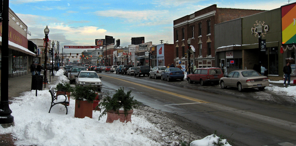


Ferndale, Michigan
Ferndale is a city of 19,190 people in Oakland County, Michigan, founded in 1918.
Why visit Ferndale
Townapedia lists 48 museums and landmarks, 69 parks and trails, 179 places to eat and 6 attractions in and around town.
Highlights include Detroit Zoo, University of Detroit Mercy, B and C Grocery Building and Birwood Wall.
July is the warmest month, with average highs of 84°F; January lows average 20°F.
Weather in Ferndale
Forecast from the National Weather Service. Full forecast
About Ferndale
Ferndale is a city in Oakland County, Michigan, United States. An inner-ring suburb of Detroit on the Woodward Corridor, Ferndale borders Detroit to the north, roughly 10 miles (16.1 km) northwest of downtown Detroit. As of the 2020 census, the city had a population of 19,190.
From the Wikipedia article Ferndale, Michigan (this version), under CC BY-SA 4.0.
Things to do6

Detroit Zoo
Zoo and aquarium · National Register of Historic Places · 1.8 mi
Zoo in Oakland County, Michigan, US
8450 West 10 Mile Road, Royal Oak


Mark Ridley's Comedy Castle
Cinema and theater · 2.0 mi
310 South Troy Street, Royal Oak
Museums and landmarks48

B and C Grocery Building
Monument and historic site · National Register of Historic Places · 2.0 mi
Historic building in Royal Oak, Michigan, USA

Birwood Wall
Monument and historic site · National Register of Historic Places · 2.2 mi
Wall in Detroit, Michigan, US

Greenfield Union School
Monument and historic site · National Register of Historic Places · 2.2 mi
School in Detroit, Michigan, United States

Highland Park Ford Plant
Monument and historic site · National Register of Historic Places · 3.7 mi
Place in Michigan listed on National Register of Historic Places

Hilzinger Block
Monument and historic site · National Register of Historic Places · 2.2 mi
Commercial building located at 106-110 South Main Street in Royal Oak, Michigan

Louis G. Redstone Residential Historic District
Monument and historic site · National Register of Historic Places · 2.7 mi
Historic district in Michigan, United States

Medbury's-Grove Lawn Subdivisions Historic District
Monument and historic site · National Register of Historic Places · 3.4 mi
Historic district in Michigan, United States

Michigan State Fair Riding Coliseum, Dairy Cattle Building, and Agricultural Building
Monument and historic site · National Register of Historic Places · 1.3 mi
Group of former buildings at the Michigan State Fairgrounds

Palmer Park Apartment Building Historic District
Monument and historic site · National Register of Historic Places · 2.9 mi
Human settlement in Detroit, Michigan, United States of America

Palmer Park Boulevard Apartments District
Monument and historic site · National Register of Historic Places · 3.0 mi
Historic district in Michigan, United States

Palmer Woods Historic District
Monument and historic site · National Register of Historic Places · 1.7 mi
Human settlement in Detroit, Michigan, United States of America


Pleasant Ridge East Historic District
Monument and historic site · National Register of Historic Places · 0.8 mi
Historic district in Michigan, USA
36 more on the map.
Parks, trails and playgrounds69


Palmer Park (Detroit)
Park · 2.4 mi
Park in Detroit, United States of America
57 more on the map.
Restaurants and cafes179

Baker's Keyboard Lounge
Restaurant · 1.1 mi
20510 Livernois Avenue, Detroit
Tu-Fr 11:00-01:00; Sa 16:00-01:00; Su 13:00-00:30

Honey Dirt Coffee Company
Cafe · Coffee Shop
Serves delicious lattes, matcha, and espresso. drinks
22801 Woodward Avenue, Ferndale
Mo-Th off; Fr 12:00-19:00; Sa 11:00-19:00; Su 11:00-18:00


Jim Brady's Detroit
Diner · American · 1.5 mi
1214 South Main Street, Royal Oak
Mo-Sa 11:00-22:00; Su 11:00-21:00

Motor City Gas
Bar and pub · Pizza · 2.0 mi
325 East 4th Street
We-Th 17:00-22:00; Fr 17:00-23:00; Sa 14:00-23:00; Su 14:00-20:00
Noorjahan Indian Cuisine
Restaurant · Indian
22821 Woodward Avenue, Ferndale
Mo-Th 11:00-22:00; Fr-Sa 11:00-03:00, Su 12:00-21:00
Qahwati Café
Cafe · Coffee Shop, Tea, Pastry
22754 Woodward Avenue, Ferndale
Mo-Th 07:00-20:00; Fr 07:00-21:00; Sa 08:00-21:00; Su 08:00-20:00
Romolo Bar Romana
Restaurant · Italian · 0.9 mi
23810 North Woodward Avenue, Pleasant Ridge
Tu-We 16:00-21:00; Th 16:00-22:00; Fr-Sa 16:00-00:00
The Blue Nile
Restaurant · Ethiopian · 0.5 mi
545 West 9 Mile Road, Ferndale
We-Th 17:00-21:30; Fr-Sa 16:00-22:00; Su 15:00-21:00
Anita's Kitchen
Restaurant · American, Lebanese
22651 Woodward Avenue, Ferndale
Mo-Sa 11:30-21:00; Su 11:30-20:00
167 more on the map.
History
Native Americans were original inhabitants of the area now known as the City of Ferndale. In the 1800s farmers began cultivating the land. After the invention of the automobile and the development of the automotive assembly line, the population of Ferndale increased rapidly.
Ferndale was incorporated into a village in 1918. It was then incorporated into a city on April 4, 1927, by vote of the citizens of the village. It became a bedroom community for Detroit workers, with most of its growth in housing from 1920 to 1951. Through the early 1950s there were trolley (interurban railroad) lines in the median strip of Woodward Avenue from downtown Detroit to Pontiac. These helped the northern suburbs of Detroit grow as bedroom communities as people could take the trolley to shop or work in Detroit.
In the 1970s, the Ferndale suburban community emerged as a place for families to raise children during the "Baby Boom" era, with its elementary schools, a downtown, city parks, active churches and civic groups. Ferndale High was completed in 1958, replacing the older Lincoln High School.
From the History section of Ferndale, Michigan on Wikipedia, under CC BY-SA 4.0.
Churches and places of worship45
Assumption of the Virgin Mary Russian Orthodox Church
Church · Russian Orthodox · 0.7 mi
2101 Livernois Street, Ferndale
First United Methodist Church
Church · National Register of Historic Places · 3.4 mi
New Mount Vernon Baptist Church
Church · Baptist · 1.8 mi
21009 Ithaca Avenue, Ferndale
Drayton Avenue Presbyterian Church of Ferndale
Church · Presbyterian · 1.0 mi
2441 Pinecrest Drive, Ferndale
El-Shaddai Missionary Baptist Church
Church · Baptist · 1.1 mi
928 East 10 Mile Road, Ferndale
Ferndale Free Methodist Church
Church · Methodist · 0.9 mi
1950 Woodward Heights Boulevard, Ferndale
First United Methodist Church of Ferndale
Church · Methodist
22331 Woodward Avenue, Ferndale
Greater Mount Olive Baptist Church
Church · Baptist · 1.4 mi
605 West 8 Mile Road, Detroit
Oak Grove AME
Church · African Methodist Episcopal · 1.9 mi
19801 Cherrylawn Avenue, Detroit
Oak Park Missionary Baptist Church
Church · Baptist · 1.0 mi
1560 Wordsworth Street, Ferndale
Shopping34
Gas and EV charging29
Schools, colleges and libraries67
Hazel Park Memorial Public Library
Library · 1.4 mi
123 East 9 Mile Road, Hazel Park
Agbu Alexmarie Manoogian School
School · 4.5 mi
22001 Northwestern Hwy, Southfield
Commonwealth Community Development Academy
School · 4.9 mi
13477 Eureka St, Hamtramck
Healthcare15
Ferndale Family Pharmacy
Clinic and pharmacy · 0.6 mi
753 West 9 Mile Road, Ferndale
Health Choice Pharmacy
Clinic and pharmacy · 0.5 mi
600 West 9 Mile Road, Ferndale
Premier Care Pharmacy
Clinic and pharmacy · 0.4 mi
23131 Woodward Avenue, Ferndale
Bi-County Urgent Care
Clinic and pharmacy · 1.6 mi
116 West 8 Mile Road, Hazel Park
Map of Ferndale
250 places. The map loads OpenStreetMap tiles when you open it.
Climate by month
Monthly table
| Month | High | Low | Rain |
|---|---|---|---|
| Jan | 32°F | 20°F | 1.4 in |
| Feb | 35°F | 21°F | 1.4 in |
| Mar | 45°F | 28°F | 2.0 in |
| Apr | 58°F | 39°F | 2.8 in |
| May | 70°F | 50°F | 3.5 in |
| Jun | 79°F | 60°F | 3.1 in |
| Jul | 84°F | 65°F | 3.2 in |
| Aug | 81°F | 64°F | 3.1 in |
| Sep | 74°F | 56°F | 3.1 in |
| Oct | 61°F | 45°F | 2.3 in |
| Nov | 48°F | 34°F | 2.2 in |
| Dec | 37°F | 26°F | 1.7 in |
U.S. Climate Normals 1991-2020 for Detroit City Ap (7 mi away), NOAA NCEI.
People and cost of living
American Community Survey 5-year estimates, 2020-2024, U.S. Census Bureau. Estimates have margins of error, larger for small towns.
Disaster history
Oakland County has had 10 federal disaster declarations since 2000, most often for severe storms.
- 2024-02-08: Severe Storms, Tornadoes, And Flooding (Flood)
- 2021-07-15: Severe Storms, Flooding, And Tornadoes (Severe Storm)
- 2020-03-27: Covid-19 Pandemic (Biological)
- 2020-03-13: Covid-19 (Biological)
- 2014-09-25: Severe Storms And Flooding (Flood)
- 2005-09-07: Hurricane Katrina Evacuation (Hurricane)
OpenFEMA disaster declarations summaries.
Getting there and nearby towns
Coleman A. Young Municipal Airport (DET) is the nearest airport with scheduled flights listed in OpenStreetMap, 7 miles away.
- Berkley 4 mi northwest, about 6 min by car
- Detroit 5 mi south, about 9 min by car
- Clawson 5 mi north, about 9 min by car
- Warren 6 mi northeast, about 9 min by car
- Birmingham 7 mi northwest, about 12 min by car
- Beverly Hills 7 mi northwest, about 11 min by car
- Eastpointe 9 mi east, about 15 min by car
- Sterling Heights 10 mi northeast, about 16 min by car
- Dearborn 11 mi south, about 18 min by car
- Dearborn Heights 12 mi southwest, about 19 min by car
Drive times are estimates from straight-line distance, not routes.
Local news
Headlines from INDB, the NEMICO news database.
Reviews, tips and questions
Loading what members have shared...
Sources and licences
- NCES EDGE (Public domain): public schools
- NOAA NCEI U.S. Climate Normals 1991-2020 (Public domain): climate by month
- OpenFEMA (Public domain): disaster declarations
- OpenStreetMap contributors (ODbL 1.0): places, airports, map data
- U.S. Census Bureau (Public domain): population, income, housing, education, commute
- Wikidata (CC0 1.0): elevation, founding date, time zone, website, landmarks and historic places
- Wikimedia Commons (see each image): photos
- Wikipedia (CC BY-SA 4.0): overview and history text
Photo credits
- Downtown Ferndale mi, Stanthejeep at English Wikipedia, CC BY-SA 3.0
- Ferndale City Hall, Summer 2016, Kara dubs, CC BY-SA 4.0
- Downtown Ferndale MI (2020), Lrgjr72, CC BY-SA 4.0
- Dormition Cathedral - Ferndale, Michigan 02, Farragutful, CC BY-SA 4.0
- Dormition Cathedral - Ferndale, Michigan 05, Farragutful, CC BY-SA 4.0
- Dormition Cathedral - Ferndale, Michigan 04, Farragutful, CC BY-SA 4.0
- Dormition Cathedral - Ferndale, Michigan 01, Farragutful, CC BY-SA 4.0
- Dormition Cathedral - Ferndale, Michigan 06, Farragutful, CC BY-SA 4.0
- Dormition Cathedral - Ferndale, Michigan 03, Farragutful, CC BY-SA 4.0
- Detroit Zoo, WMrapids, CC0
- Palmer Park Apartment Buildings, Detroit MI, Andrew Jameson, CC BY-SA 3.0
- Medbury's-Grove Lawn Subdivisions Historic District 4, Andrew Jameson, CC BY-SA 3.0
- Pleasant Ridge East Historic District A, Andrew Jameson, CC BY-SA 3.0
- First United Methodist Church Highland Park, Andrew Jameson ( talk ) at en.wikipedia, CC BY-SA 3.0
- Michigan State Fair Detroit MI, Andrew Jameson, CC BY-SA 3.0
- Hilzinger Block Royal Oak MI, Andrew Jameson, CC BY-SA 3.0
- Greenfield Union School Detroit MI, Andrew Jameson, CC BY-SA 3.0
- Palmer Woods Streetscape, Detroit MI, Andrew Jameson, CC BY-SA 3.0
- Palmer Park Apartment Building Historic District Detroit 2, Andrew Jameson, CC BY-SA 3.0
- Birwood Wall in 2022, City of Detroit, Public domain
- B and C Grocery Building Royal Oak MI, Andrew Jameson, CC BY-SA 3.0
- Farm Mechanics 1922 Ford Highland Park cropped, Bernard L. Johnson, Public domain
- Pleasant Ridge Historic District A, Andrew Jameson, CC BY-SA 3.0
- Chaldeanchurch, Chaldean at en.wikipedia, CC BY-SA 3.0
- 1969 Shelby GT500 (7841600238), Mustang Joe, CC0
- 1965 Shelby GT350 advanced prototype SFM5012 (53131984636), Mustang Joe, CC0
- 2024 Ford Mustang Dark Horse (53132468838), Mustang Joe, CC0
- 2015 Ford Mustang GT (14835773649), Mustang Joe, CC0
- 1970 Mustang Boss 302 (6119944305), Mustang Joe, CC0
- 1970 Ford Shelby GT350 Convertible (14786356087), Mustang Joe, CC0
- 1969 Ford Mustang Mach 1 (9553444529), Mustang Joe, CC0
- Mustang Alley (7840279188), Mustang Joe, CC0
- 2017 Ford GT (36321694300), Mustang Joe, CC0
- 1969 Ford Mustang Mach 1 (7824105746), Mustang Joe, CC0
- Motor City Pride 2007 - volunteer - 3540, File made available by varnent through the LGBT Free Media Collective, CC BY-SA 3.0
- Motor City Pride 2007 - Generation.OUT Zone - 3555, File made available by varnent through the LGBT Free Media Collective, CC BY-SA 3.0
- Motor City Pride 2007 - crowd - 3535, File made available by varnent through the LGBT Free Media Collective, CC BY-SA 3.0
- Motor City Pride 2007 - Triangle Foundation area - 3552, File made available by varnent through the LGBT Free Media Collective, CC BY-SA 3.0
- Motor City Pride 2007 - crowd - 3548, File made available by varnent through the LGBT Free Media Collective, CC BY-SA 3.0
- Motor City Pride 2007 - crowd - 3543, File made available by varnent through the LGBT Free Media Collective, CC BY-SA 3.0


Page built October 30, 2026. Spotted a mistake? Tell us or suggest a place.