



Flat Rock, North Carolina
Flat Rock is a community of 1,062 people in Surry County, North Carolina.
Why visit Flat Rock
Townapedia lists 10 museums and landmarks, 5 parks and trails, 15 places to eat and 3 attractions in and around town.
Highlights include Mount Airy Historic District, William Alfred Moore House, Riverside Park and Tharrington Park.
July is the warmest month, with average highs of 86°F; January lows average 25°F.
Weather in Flat Rock
Forecast from the National Weather Service. Full forecast
About Flat Rock
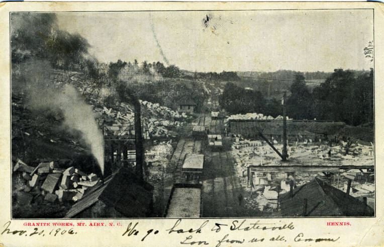
Flat Rock is a census-designated place (CDP) in Surry County, North Carolina, United States. The name "Flat Rock" stems from the community's granite quarry. The granite quarry is the largest open-face granite quarry in the world, and has been mined continuously since 1889 by the North Carolina Granite Corporation.
From the Wikipedia article Flat Rock, Surry County, North Carolina (this version), under CC BY-SA 4.0.
Things to do3

Andy Griffith Playhouse
Cinema and theater · 1.6 mi
218 Rockford Street, Mount Airy
Blackmon Amphitheatre
Cinema and theater · 1.6 mi
Amphitheater
231 Spring Street, Mount Airy
Museums and landmarks10

Mount Airy Historic District
Monument and historic site · National Register of Historic Places · 1.5 mi
Historic district in North Carolina, USA

William Alfred Moore House
Monument and historic site · National Register of Historic Places · 1.4 mi
Mount Airy, North Carolina, NRHP-listed
202 Moore Avenue, Mount Airy

Edgar Harvey Hennis House
Monument and historic site · National Register of Historic Places · 1.5 mi
Historic house in North Carolina, United States
North Carolina Granite Corporation Quarry Complex
Monument and historic site · National Register of Historic Places
Historic district in North Carolina, United States

Renfro Mill
Monument and historic site · National Register of Historic Places · 1.6 mi
Tobacco mill in Mount Airy, North Carolina


W. F. Carter House
Monument and historic site · National Register of Historic Places · 1.5 mi
Mount Airy, North Carolina, NRHP-listed in Surry County

Mount Airy Museum of Regional History
Museum · 1.5 mi
301 North Main Street, Mount Airy
Tu-Sa 10:00-17:00

Wally's Service Station
Monument and historic site · 1.4 mi
Attraction: Wally's Service Station from the Andy Griffith Show. Where Goober worked. See historic cars, police cars from the show's...
625 South Main Street, Mount Airy
Parks, trails and playgrounds5

Riverside Park
Park · 1.1 mi
Soccer Field (Lighted), Basketball Court (Outdoors), All-Purpose Blacktop, 2 Picnic Shelters, Playground, Tot-Lot, Trail Access, Skate...
350 Riverside Drive, Mount Airy
Tharrington Park
Park · 1.7 mi
Soccer Fields (2), River Access, Trail Access, Fishing
1038 Spring St., Mount Airy
H. B. Rowe Envir. Ed. Park
Park · 1.1 mi
River Access, Trail Access, Outdoor Classroom, Fishing, 2 Family Picnic Shelters
217 Hamburg Street, Mount Airy
Restaurants and cafes15

Snappy Lunch
Restaurant · Breakfast, Lunch, Burger, Pork Sandwich · 1.5 mi
Historic diner where Andy Griffith grew up.
125 North Main Street, Mount Airy
06:00-13:45

Hillbilly Gluten Free Shop, Ic Cream Shop, and Creamery
Bakery · 1.5 mi
153 North Main Street, Mount Airy
11:30-19:00

Barney’s Cafe
Diner · American · 1.5 mi
206 North Main Street, Mount Airy
Gondola Italian Restaurant
Restaurant · Italian · 1.5 mi
101 West Lebanon Street, Mount Airy
Mi Casa on Main
Restaurant · Tex-Mex · 1.5 mi
243 North Main Street, Mount Airy

Thirsty Souls Community Brewing
Brewery and winery · 1.6 mi
238 Market Street, Mount Airy
Th-Fr 17:00-23:00, Sa 12:00-23:00, Su 12:00-18:00
Chase N Charli
Restaurant · 1.4 mi
1384 South Main Street, Mount Airy
Kazoku Sushi and Bar
Restaurant · Japanese, Sushi · 1.5 mi
121 Franklin Street, Mount Airy
Olympia Family Restaurant
Restaurant · Greek, Sandwich · 0.9 mi
602 Linville Road, Mount Airy
3 more on the map.
Churches and places of worship13
Trinity Episcopal Church
Church · Episcopal · National Register of Historic Places · 1.4 mi
Bannertown Baptist Church
Church · Baptist · 1.5 mi
1834 Westfield Road, Mount Airy
Shopping4
Creative Designs Flowers & Gifts
Shop · 1.4 mi
1220 South Main Street, Mount Airy
Gas and EV charging1
Schools, colleges and libraries15
Healthcare1
Map of Flat Rock
67 places. The map loads OpenStreetMap tiles when you open it.
Climate by month
Monthly table
| Month | High | Low | Rain | Snow |
|---|---|---|---|---|
| Jan | 47°F | 25°F | 4.0 in | 3.1 in |
| Feb | 51°F | 27°F | 3.1 in | 2.2 in |
| Mar | 58°F | 33°F | 4.2 in | 1.2 in |
| Apr | 68°F | 41°F | 4.3 in | 0.0 in |
| May | 76°F | 50°F | 4.5 in | 0.0 in |
| Jun | 83°F | 59°F | 5.0 in | 0.0 in |
| Jul | 86°F | 63°F | 5.2 in | 0.0 in |
| Aug | 85°F | 62°F | 4.7 in | 0.0 in |
| Sep | 79°F | 56°F | 4.3 in | 0.0 in |
| Oct | 70°F | 43°F | 3.5 in | 0.0 in |
| Nov | 59°F | 32°F | 3.4 in | 0.0 in |
| Dec | 50°F | 28°F | 4.2 in | 1.7 in |
U.S. Climate Normals 1991-2020 for Mt Airy 2 W Hcn (4 mi away), NOAA NCEI.
People and cost of living
American Community Survey 5-year estimates, 2020-2024, U.S. Census Bureau. Estimates have margins of error, larger for small towns.
Disaster history
Surry County has had 13 federal disaster declarations since 2000, most often for hurricanes.
- 2026-01-24: Severe Winter Storm (Winter Storm)
- 2024-09-28: Tropical Storm Helene (Tropical Storm)
- 2024-09-26: Hurricane Helene (Tropical Storm)
- 2024-08-06: Tropical Storm Debby (Tropical Storm)
- 2022-10-01: Hurricane Ian (Hurricane)
- 2020-08-02: Hurricane Isaias (Hurricane)
OpenFEMA disaster declarations summaries.
Getting there and nearby towns
Smith-Reynolds International Airport (INT) is the nearest airport with scheduled flights listed in OpenStreetMap, 33 miles away.
- Mount Airy 2 mi west, about 3 min by car
- Dobson 11 mi southwest, about 18 min by car
- Boonville 20 mi south, about 33 min by car
- Elkin 22 mi southwest, about 36 min by car
- Lewisville 29 mi south, about 47 min by car
- Winston-Salem 33 mi southeast, about 53 min by car
- Clemmons 35 mi south, about 56 min by car
- Bermuda Run 36 mi south, about 58 min by car
- Kernersville 39 mi southeast, about 1 h by car
- Martinsville 42 mi east, about 1 h by car
Drive times are estimates from straight-line distance, not routes.
Local news
Headlines from INDB, the NEMICO news database.
Reviews, tips and questions
Loading what members have shared...
Sources and licences
- NCES EDGE (Public domain): public schools
- NOAA NCEI U.S. Climate Normals 1991-2020 (Public domain): climate by month
- OpenFEMA (Public domain): disaster declarations
- OpenStreetMap contributors (ODbL 1.0): places, airports, map data
- U.S. Census Bureau (Public domain): population, income, housing, education, commute
- Wikidata (CC0 1.0): landmarks and historic places
- Wikimedia Commons (see each image): photos
- Wikipedia (CC BY-SA 4.0): overview and history text
Photo credits
- Mount Airy Historic District, G Keith Hall, CC BY-SA 3.0
- William Alfred Moore House, Dmw002, CC BY-SA 3.0
- Trinity Episcopal Church Mt. Airy, Dmw002, CC BY-SA 3.0
- Renfro Mill, Dmw002, CC BY-SA 3.0
- Granite Works, Mt. Airy, N.C., 1906, Nmg27510, Public domain
- W.F. Carter House from east, Nyttend, Public domain
- Edgar Harvey Hennis House, Nyttend, Public domain
Page built October 30, 2026. Spotted a mistake? Tell us or suggest a place.