
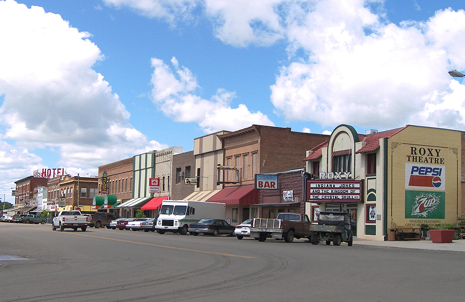


Forsyth, Montana
Forsyth is a city of 1,728 people in Rosebud County, Montana, founded in 1876.
Why visit Forsyth
Townapedia lists 11 museums and landmarks, 5 parks and trails, 10 places to eat, 7 places to stay and 2 attractions in and around town.
Highlights include Forsyth Bridge, Roxy Theatre, Brotherhood of Locomotive Engineers Hall and Claude O. Marcyes House.
July is the warmest month, with average highs of 88°F; January lows average 10°F, and about 35 inches of snow fall in a normal year.
Weather in Forsyth
Forecast from the National Weather Service. Full forecast
About Forsyth
Forsyth is a city in and the county seat of Rosebud County, Montana, United States. The population was 1,647 at the 2020 census. Forsyth was established in 1876 as the first settlement on the Yellowstone River, and in 1882 residents named the town after General James William Forsyth who commanded Fort Maginnis, Montana during the Indian Wars and the 7th Cavalry at the Wounded Knee Massacre. The town has long been a transportation nexus, starting with steamboats on the river and progressing to the Northern Pacific Railway and Interstate 94.
From the Wikipedia article Forsyth, Montana (this version), under CC BY-SA 4.0.
Things to do2

Forsyth Bridge
Bridge · National Register of Historic Places · 0.9 mi
Road bridge in Rosebud County, United States of America

Museums and landmarks11

Brotherhood of Locomotive Engineers Hall
Monument and historic site · National Register of Historic Places · 0.6 mi
Office building in Forsyth, Montana
Claude O. Marcyes House
Monument and historic site · National Register of Historic Places · 0.6 mi
House in Forsyth, Montana
Cold Springs Ranch House
Monument and historic site · National Register of Historic Places · 2.4 mi
Farmhouse in Rosebud County, Montana
Forsyth Main Street Historic District
Monument and historic site · National Register of Historic Places
Historic district in Montana, United States
Forsyth Residential Historic District
Monument and historic site · National Register of Historic Places
Historic district in Forsyth, Montana
Forsyth Water Pumping Station
Monument and historic site · National Register of Historic Places · 0.8 mi
Building in Forsyth, United States of America
Herman and Hannah Anderson House
Monument and historic site · National Register of Historic Places · 0.5 mi
United States historic place
Rosebud County Courthouse
Monument and historic site · National Register of Historic Places
County courthouse in Forsyth, Montana
Rosebud County Deaconess Hospital
Monument and historic site · National Register of Historic Places
Hospital in Montana, United States
Blue Front Rooming House
Monument and historic site · National Register of Historic Places

Parks, trails and playgrounds5


Restaurants and cafes10







History
Forsyth was established as a settlement on the Yellowstone in 1876 as a steamboat landing supporting United States Army operations in the Indian Wars.
in 1882, Thomas Alexander traded land to the Northern Pacific Railway to start the town, and developed four buildings on main street.
On April 21, 1894, several hundred men of Coxey's Army, inspired by Jacob Coxey and led by William Hogan, commandeered a Northern Pacific Railway train in Butte, Montana headed for Washington, DC. After stopping in Bozeman, they fought Federal Marshals in Billings with one man killed and several wounded. They were finally apprehended in Forsyth on April 25, by five companies of the 22nd Infantry Regiment and Troop L, 8th Cavalry from Fort Keogh, Cheyenne soldiers known as "Casey's scouts." The incident marked one of the few instances in American history where U.S. Native American troops were used against white civilians. Although some escapes occurred, 331 of the Coxeyites were taken to Helena as prisoners.
In the 1980s Forsyth served as the home of the United States Air Force 1st Combat Evaluation Group Detachment 18, evaluating radar observability for B-52s on training runs.
From the History section of Forsyth, Montana on Wikipedia, under CC BY-SA 4.0.
Where to stay7
Churches and places of worship10
First Presbyterian Church and Manse
Church · National Register of Historic Places
Immaculate Conception Catholic Church
Church · Roman Catholic
509 North 12th Avenue, Forsyth
Concordia Lutheran Church
Church · Lutheran · 0.5 mi
310 North 8th Avenue, Forsyth
Kingdom Hall of Jehovah's Witnesses
Church · Jehovahs Witness · 0.5 mi
110 North 7th Avenue, Forsyth
Shopping3
Gas and EV charging1
Schools, colleges and libraries5
Healthcare4
Rosebud County Child and Family Services
Clinic and pharmacy
121 North 11th Avenue, Forsyth
Map of Forsyth
58 places. The map loads OpenStreetMap tiles when you open it.
Climate by month
Monthly table
| Month | High | Low | Rain | Snow |
|---|---|---|---|---|
| Jan | 34°F | 10°F | 0.6 in | 7.7 in |
| Feb | 38°F | 14°F | 0.6 in | 7.3 in |
| Mar | 49°F | 23°F | 0.9 in | 3.9 in |
| Apr | 59°F | 33°F | 1.9 in | 2.8 in |
| May | 69°F | 43°F | 2.9 in | 0.4 in |
| Jun | 78°F | 52°F | 2.5 in | 0.0 in |
| Jul | 88°F | 58°F | 1.4 in | 0.0 in |
| Aug | 86°F | 56°F | 1.2 in | 0.0 in |
| Sep | 75°F | 46°F | 1.4 in | 0.1 in |
| Oct | 60°F | 34°F | 1.4 in | 1.5 in |
| Nov | 46°F | 22°F | 0.7 in | 4.0 in |
| Dec | 35°F | 13°F | 0.6 in | 6.9 in |
U.S. Climate Normals 1991-2020 for Forsyth (0 mi away), NOAA NCEI.
People and cost of living
American Community Survey 5-year estimates, 2020-2024, U.S. Census Bureau. Estimates have margins of error, larger for small towns.
Disaster history
Rosebud County has had 13 federal disaster declarations since 2000, most often for fires.
- 2026-04-07: Severe Winter Storm And Straight-Line Winds (Straight-Line Winds)
- 2021-09-30: Richard Spring Fire (Fire)
- 2021-08-10: Richard Spring Fire (Fire)
- 2020-09-03: Snider/Rice Fire Complex (Fire)
- 2020-03-31: Covid-19 Pandemic (Biological)
- 2020-03-13: Covid-19 (Biological)
OpenFEMA disaster declarations summaries.
Getting there and nearby towns
Frank Wiley Field (MLS) is the nearest airport with scheduled flights listed in OpenStreetMap, 39 miles away.
- Colstrip 26 mi south, about 42 min by car
- Miles City 41 mi east, about 1 h by car
- Lame Deer 45 mi south, about 1 h 15 min by car
- Muddy 48 mi south, about 1 h 15 min by car
- Ashland 50 mi south, about 1 h 15 min by car
- Busby 53 mi south, about 1 h 30 min by car
Drive times are estimates from straight-line distance, not routes.
Local news
Headlines from INDB, the NEMICO news database.
Reviews, tips and questions
Loading what members have shared...
Sources and licences
- NCES EDGE (Public domain): public schools
- NOAA NCEI U.S. Climate Normals 1991-2020 (Public domain): climate by month
- OpenFEMA (Public domain): disaster declarations
- OpenStreetMap contributors (ODbL 1.0): places, airports, map data
- U.S. Census Bureau (Public domain): population, income, housing, education, commute
- Wikidata (CC0 1.0): elevation, founding date, time zone, website, landmarks and historic places
- Wikimedia Commons (see each image): photos
- Wikipedia (CC BY-SA 4.0): overview and history text
Photo credits
- Forsyth montana 2008, Larry D. Moore, CC BY 4.0
- Forsyth Residential Historic District3 NRHP 90000082 Rosebud County, MT, Jon Roanhaus, CC BY-SA 4.0
- Forsyth Residential Historic District2 NRHP 90000082 Rosebud County, MT, Jon Roanhaus, CC BY-SA 4.0
- Forsyth Residential Historic District NRHP 90000082 Rosebud County, MT, Jon Roanhaus, CC BY-SA 4.0
- Greetings from Forsyth, Montana - Large Letter Postcard (5708898506), Steve Shook from Moscow, Idaho, USA, CC BY 2.0
- Forsyth Water Pumping Station NRHP 90000087 Rosebud County, MT, Jon Roanhaus, CC BY-SA 4.0
- Forsyth Water Pumping Station2 NRHP 90000087 Rosebud County, MT, Jon Roanhaus, CC BY-SA 4.0
- Forsyth Bridge NRHP 90000090 Rosebud Counry, MT, Jon Roanhaus, CC BY-SA 4.0
- Forsyth Bridge2 NRHP 90000090 Rosebud Counry, MT, Jon Roanhaus, CC BY-SA 4.0
- Rosebud county courthouse, Larry D. Moore, CC BY 4.0
- First Presbyterian Church and Manse NRHP 90000089 Rosebud County, MT, Jon Roanhaus, CC BY-SA 4.0
- First Presbyterian Church and Manse2 NRHP 90000089 Rosebud County, MT, Jon Roanhaus, CC BY-SA 4.0
- Blue Front Rooming House2 NRHP 90000085 Rosebud County, MT, Jon Roanhaus, CC BY-SA 4.0
- Blue Front Rooming House NRHP 90000085 Rosebud County, MT, Jon Roanhaus, CC BY-SA 4.0
- Rosebud County Deaconess Hospital NRHP 79001425 Rosebud County, MT, Jon Roanhaus, CC BY-SA 4.0
- Herman and Hannah Anderson House NRHP 90000084 Rosebud County, MT, Jon Roanhaus, CC BY-SA 4.0
- Brotherhood of Locomotive Engineers Hall NRHP 90000086 Rosebud County, MT, Jon Roanhaus, CC BY-SA 4.0
- Claude O. Marcyes House NRHP 90000088 Rosebud County, MT, Jon Roanhaus, CC BY-SA 4.0
- Claude O. Marcyes House2 NRHP 90000088 Rosebud County, MT, Jon Roanhaus, CC BY-SA 4.0


Page built October 30, 2026. Spotted a mistake? Tell us or suggest a place.