


Why visit Fort Madison
Townapedia lists 27 museums and landmarks, 10 parks and trails, 17 places to eat, 6 places to stay and 1 attraction in and around town.
Highlights include Fox Theater, Cattermole Memorial Library and Albright House.
July is the warmest month, with average highs of 85°F; January lows average 17°F.
Weather in Fort Madison
Forecast from the National Weather Service. Full forecast
About Fort Madison
Fort Madison is a city in and the county seat of Lee County, Iowa, United States along with Keokuk. Of Iowa's 99 counties, Lee County is the only one with two county seats. The population was 10,270 as of the 2020 census, and was estimated at 9,935 in 2025. Located along the Mississippi River in the state's southeast corner, it lies between small bluffs along one of the widest portions of the river.
From the Wikipedia article Fort Madison, Iowa (this version), under CC BY-SA 4.0.
Things to do1

Museums and landmarks27

Cattermole Memorial Library
Monument and historic site · National Register of Historic Places · 2.0 mi
Historic library in Iowa

Albright House
Monument and historic site · National Register of Historic Places · 2.0 mi
United States historic place

Atchison, Topeka and Santa Fe Passenger and Freight Complex Historic District
Monument and historic site · National Register of Historic Places · 1.8 mi
Railway station in Fort Madison, the United States of America
Cambre House and Farm
Monument and historic site · National Register of Historic Places · 1.9 mi
Historic house in Illinois, United States
Chief Justice Joseph M. Beck House
Monument and historic site · National Register of Historic Places · 2.1 mi
House in Fort Madison, Iowa
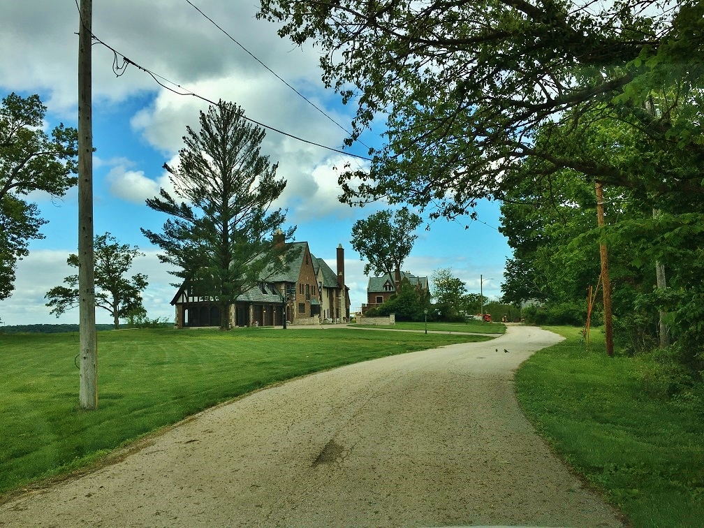


Craig and Virginia Sheaffer House
Monument and historic site · National Register of Historic Places · 3.3 mi
House in Fort Madison, Iowa
Fort Madison Downtown Commercial Historic District
Monument and historic site · National Register of Historic Places · 2.0 mi
Historic district in Fort Madison, Iowa

Fort Madison Toll Bridge
Bridge · National Register of Historic Places · 2.7 mi
Bridge in and Niota, Illinois
George E. Schlapp House
Monument and historic site · National Register of Historic Places · 2.2 mi
Historic house in Iowa, United States
Holy Family Catholic Church
Monument and historic site · National Register of Historic Places · 1.8 mi
Church in Iowa, United States
15 more on the map.
Parks, trails and playgrounds10



Restaurants and cafes17

Casa Jalisco
Restaurant · Mexican · 1.5 mi
4821 Highway 61
Mo-Th,Su 11:00-21:00; Fr,Sa 11:00-22:00

Palms Supper Club
Diner · American · 1.6 mi
4920 Avenue O, Fort Madison



Burger King
Fast food · Burger · 1.5 mi
4805 Avenue O, Fort Madison
Mo-Th 06:00-23:00; Fr-Sa 06:00-24:00; Su 07:00-23:00
5 more on the map.
History
Fort Madison was founded as the location of the first U.S. military fort in the upper Mississippi region. A replica of the fort stands along the river. Sheaffer Pens were developed and made in Fort Madison for many years. The city is the location of the Iowa State Penitentiary—the state's maximum security prison for men. Fort Madison is the Mississippi river crossing and station stop for Amtrak's Southwest Chief. Fort Madison has one of two remaining double swing-span bridges on the Mississippi River, the Fort Madison Toll Bridge, the other being the Government Bridge in Rock Island, Illinois. It has a top level for cars and a similar level for trains; it is also the world's largest.
The Fort Madison Downtown Commercial Historic District is a collection of well-preserved historic storefronts from the late 19th century. Along with this is the Park-to-Park Residential Historic District. The Historic Park to Park District is a seven block long, three block wide section of homes that represent the Gothic, Victorian, and Tudor era. With a rich variety of architectural styles like Gothic Revival, Italianate, Second Empire, Eastlake Stick, Richardson Romanesque, Queen Anne, and Tudor. With two of the six parks within the District. It is on the National Historic Registry.
From the History section of Fort Madison, Iowa on Wikipedia, under CC BY-SA 4.0.
Where to stay6
Churches and places of worship27
Shopping10
Gas and EV charging7
Schools, colleges and libraries12
Healthcare5
Fort Madison Community Hospital Physician & Professional Offices
Clinic and pharmacy · 2.0 mi
5409 Avenue O, Fort Madison
Map of Fort Madison
122 places. The map loads OpenStreetMap tiles when you open it.
Climate by month
Monthly table
| Month | High | Low | Rain | Snow |
|---|---|---|---|---|
| Jan | 33°F | 17°F | 1.7 in | 6.1 in |
| Feb | 38°F | 21°F | 1.9 in | 4.6 in |
| Mar | 50°F | 32°F | 2.7 in | 1.7 in |
| Apr | 62°F | 42°F | 4.0 in | 0.5 in |
| May | 72°F | 54°F | 5.1 in | 0.0 in |
| Jun | 82°F | 63°F | 5.2 in | 0.0 in |
| Jul | 85°F | 68°F | 4.1 in | 0.0 in |
| Aug | 84°F | 66°F | 3.8 in | 0.0 in |
| Sep | 77°F | 57°F | 3.5 in | 0.0 in |
| Oct | 64°F | 45°F | 3.1 in | 0.1 in |
| Nov | 50°F | 33°F | 2.4 in | 0.8 in |
| Dec | 38°F | 23°F | 1.9 in | 4.3 in |
U.S. Climate Normals 1991-2020 for Ft Madison (1 mi away), NOAA NCEI.
People and cost of living
American Community Survey 5-year estimates, 2020-2024, U.S. Census Bureau. Estimates have margins of error, larger for small towns.
Disaster history
Lee County has had 16 federal disaster declarations since 2000, most often for severe storms.
- 2023-08-25: Flooding (Flood)
- 2020-03-23: Covid-19 Pandemic (Biological)
- 2020-03-13: Covid-19 (Biological)
- 2019-03-23: Severe Storms And Flooding (Flood)
- 2018-09-12: Severe Storm And Tornadoes (Severe Storm)
- 2015-07-31: Severe Storms, Tornadoes, Straight-Line Winds, And Flooding (Severe Storm)
OpenFEMA disaster declarations summaries.
Getting there and nearby towns
Fort Madison Municipal Airport (FMS) is the nearest airport with scheduled flights listed in OpenStreetMap, 2 miles away.
- Nauvoo 6 mi south, about 9 min by car
- Denmark 8 mi north, about 12 min by car
- Montrose 8 mi southwest, about 13 min by car
- West Point 9 mi northwest, about 14 min by car
- Dallas City 10 mi east, about 15 min by car
- Donnellson 12 mi west, about 19 min by car
- Burlington 17 mi northeast, about 28 min by car
- Macomb 36 mi east, about 59 min by car
- Quincy 48 mi south, about 1 h 15 min by car
- Galesburg 56 mi northeast, about 1 h 30 min by car
Drive times are estimates from straight-line distance, not routes.
Local news
Headlines from INDB, the NEMICO news database.
Reviews, tips and questions
Loading what members have shared...
Sources and licences
- NCES EDGE (Public domain): public schools
- NOAA NCEI U.S. Climate Normals 1991-2020 (Public domain): climate by month
- OpenFEMA (Public domain): disaster declarations
- OpenStreetMap contributors (ODbL 1.0): places, airports, map data
- U.S. Census Bureau (Public domain): population, income, housing, education, commute
- Wikidata (CC0 1.0): elevation, founding date, time zone, website, landmarks and historic places
- Wikimedia Commons (see each image): photos
- Wikipedia (CC BY-SA 4.0): overview and history text
Photo credits
- Fort Madison Iowa, Billwhittaker ( talk ), Public domain
- Fort Madison station, LHOON, CC BY-SA 2.0
- Fort Madison High School from north, Nyttend, Public domain
- Albright House in Fort Madison, Nyttend, Public domain
- Fort Madison Toll Bridge, Louis, CC BY-SA 2.0
- Lee County Courthouse, Fort Madison, Robert Thall, Public domain
- Joseph Beck House, Fort Madison, Nyttend, Public domain
- US61 South - Exit 18 - IA2 Fort Madison (41149623520), formulanone from Huntsville, United States, CC BY-SA 2.0
- Cattermole Memorial Library, ChristopherFfolger, CC BY-SA 3.0
- Walter Sheaffer House NRHP 06000858 Lee County, IA, Jon Roanhaus, CC BY-SA 3.0
- Atchison, Topeka and Santa Fe Passenger and Freight Complex, ChristopherFfolger, CC BY-SA 3.0
- McConn Barn NRHP 00000531 NRHP Lee County, IA, Jon Roanhaus, CC BY-SA 3.0
- Iowa Sky Converges (8974301194), cogdogblog, CC BY 2.0
- Moyce-Steffens House, Nyttend, Public domain
- Saint Mary Of The Assumption NRHP 80001455 Lee County, IA, Jon Roanhaus, CC BY-SA 3.0
- The Mighty Debris Filled Mississippi River (8763289596), cogdogblog, CC BY 2.0
- 2011-02-13 Atchison, Topeka and Santa Fe 2913, joannapoe, CC BY-SA 2.0
- Cambre Farm distant, Nyttend, Public domain
- Park-to-Park HD NRHP 14001069 Lee County, IA, Jon Roanhaus, CC BY-SA 3.0
- Schlapp House NRHP 82002627 Lee County, IA, Jon Roanhaus, CC BY-SA 3.0
- ISS044-E-62028 - View of Earth, Earth Science and Remote Sensing Unit , Lyndon B. Johnson Space Center, Public domain
- ISS043-E-13355 - View of Earth, Earth Science and Remote Sensing Unit , Lyndon B. Johnson Space Center, Public domain
- ISS043-E-13354 - View of Earth, Earth Science and Remote Sensing Unit , Lyndon B. Johnson Space Center, Public domain
- ISS043-E-13353 - View of Earth, Earth Science and Remote Sensing Unit , Lyndon B. Johnson Space Center, Public domain
- ISS043-E-13356 - View of Earth, Earth Science and Remote Sensing Unit , Lyndon B. Johnson Space Center, Public domain
- ISS030-E-187806 - View of Earth, Earth Science and Remote Sensing Unit , Lyndon B. Johnson Space Center, Public domain


Page built October 30, 2026. Spotted a mistake? Tell us or suggest a place.