
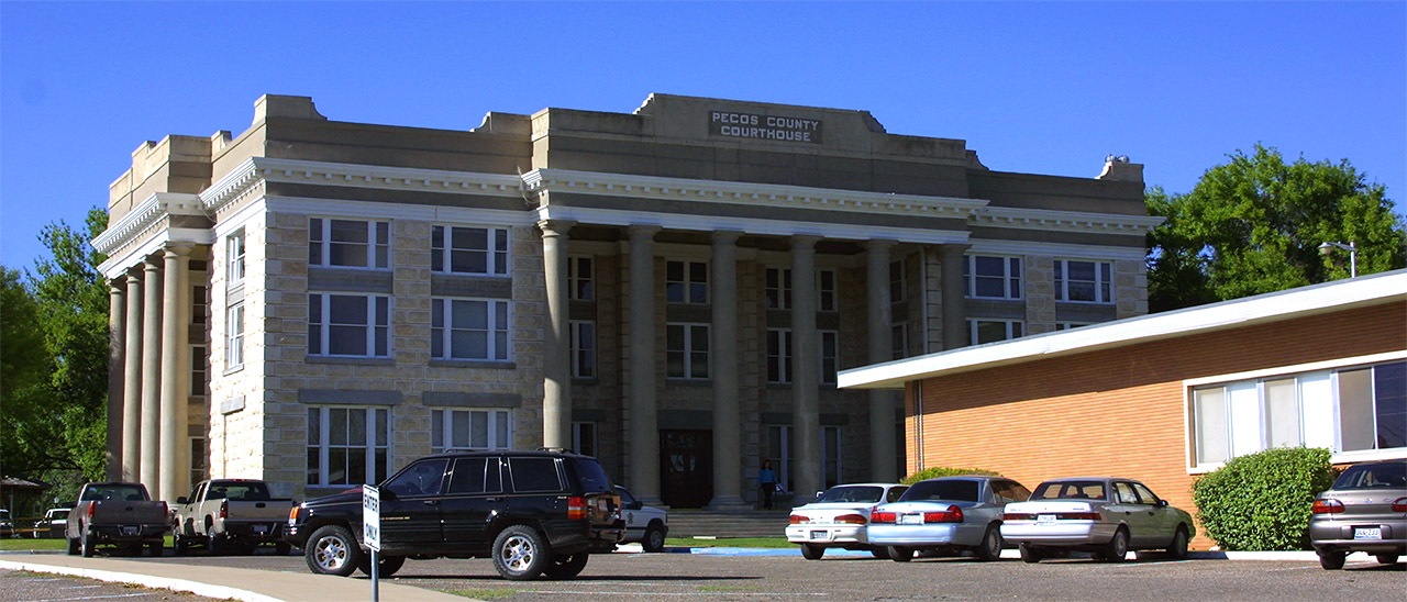


Fort Stockton, Texas
Fort Stockton is a city of 8,278 people in Pecos County, Texas, founded in 1859.
Why visit Fort Stockton
Townapedia lists 23 museums and landmarks, 10 parks and trails, 10 places to eat and 21 places to stay in and around town.
Highlights include Fort Stockton Historic District, Historic Fort Stockton, James Rooney Memorial Park and Lannom Park.
August is the warmest month, with average highs of 94°F; January lows average 36°F.
Weather in Fort Stockton
Forecast from the National Weather Service. Full forecast
About Fort Stockton
Fort Stockton is a city in and the county seat of Pecos County, Texas, United States. It is located on Interstate 10, future Interstate 14, U.S. Highways 67, 285, and 385, and the Santa Fe Railroad, 329 mi (529 km) northwest of San Antonio and 240 mi (390 km) southeast of El Paso. Its population was 8,466 at the 2020 census.
From the Wikipedia article Fort Stockton, Texas (this version), under CC BY-SA 4.0.
Museums and landmarks23

Fort Stockton Historic District
Monument and historic site · National Register of Historic Places · 0.6 mi
Historic district in Fort Stockton, Pecos County, Texas



11 more on the map.
Parks, trails and playgrounds10


Desert Pines Golf Course
Golf course · 1.8 mi
1572 Blaine McCallister Loop, Fort Stockton
Restaurants and cafes10

K. Bob's Steakhouse
Restaurant · Steak House · 1.6 mi
2800 West Dickinson Boulevard, Fort Stockton
Mo-Su 11:00-22:00
Andy's Roadhouse Bar & Grill
Restaurant · Steak House, Western, Burger, American, Grill · 1.3 mi
2129 Interstate 10 West, Fort Stockton

B's Family Diner
Diner · American · 0.6 mi
101 N Main Street, Fort Stockton
Chihuahua’s Mexican Restaurant
Restaurant · Mexican · 1.2 mi
2977 TX 18, Fort Stockton

Burger King
Fast food · Burger · 1.1 mi
2792 North Highway 18, Fort Stockton
Mo-Sa 06:00-22:00; Su 07:00-22:00
Carl's Jr.
Fast food · Burger · 1.9 mi
2723 E US HWY 290, Fort Stockton
We-Su 06:00-23:00; Mo, Tu 00:00-00:00
Domino's
Fast food · Pizza · 1.5 mi
1003 North Sycamore, Fort Stockton
Mo-Th 10:00-24:00; Fr-Sa 10:00-01:00; Su 10:00-24:00
Where to stay21

Atrium The Inn
Motel and hotel · 1.2 mi
1305 North US Highway 285, Fort Stockton
Budget Inn
Motel and hotel · 0.8 mi
801 East Dickinson Boulevard, Fort Stockton
Deluxe Inn
Motel and hotel · 0.6 mi
500 East Dickinson Boulevard, Fort Stockton
Quality Inn
Motel and hotel · 1.2 mi
1308 North US Highway 285, Fort Stockton
Texan Inn
Motel and hotel · 0.9 mi
1801 West Dickinson Boulevard, Fort Stockton
9 more on the map.
History
Fort Lancaster sent 1st Infantry Co. H "to take post" along Comanche Springs on 12 April 1859. Fort Stockton (named Camp Stockton until 1860) grew up around Comanche Springs, one of the largest sources of spring water in Texas. The fort was named for Robert F. Stockton. Comanche Springs was a favorite rest stop on the Great Comanche Trail to Chihuahua, San Antonio-El Paso Road, and the Butterfield Overland Mail route. On October 2, 1859, the well-known journalist and author (and future Union spy) Albert D. Richardson passed through Camp Stockton, which he described as "a military post of three or four edifices with pearly, misty mountains in the background."
In 1861, the fort was garrisoned by 39 men of Company C, 8th Infantry, under the command of Capt. Arthur Tracy Lee, who evacuated the fort by April. The Confederates took possession of the fort on 9 May by Charles L. Pyron at the outbreak of the Civil War, but soon turned command over to Capt. William C. Adams. With the failure of John Baylor's invasion of New Mexico, a general Confederate evacuation of West Texas occurred in 1862.
From the History section of Fort Stockton, Texas on Wikipedia, under CC BY-SA 4.0.
Churches and places of worship7
Shopping1
Gas and EV charging12
Schools, colleges and libraries16
Healthcare1
Map of Fort Stockton
101 places. The map loads OpenStreetMap tiles when you open it.
Climate by month
Monthly table
| Month | High | Low | Rain | Snow |
|---|---|---|---|---|
| Jan | 61°F | 36°F | 0.7 in | 0.5 in |
| Feb | 65°F | 39°F | 0.5 in | 0.1 in |
| Mar | 73°F | 46°F | 0.6 in | 0.0 in |
| Apr | 81°F | 53°F | 0.8 in | 0.0 in |
| May | 89°F | 62°F | 1.4 in | 0.0 in |
| Jun | 94°F | 69°F | 1.9 in | 0.0 in |
| Jul | 94°F | 71°F | 1.8 in | 0.0 in |
| Aug | 94°F | 70°F | 1.8 in | 0.0 in |
| Sep | 88°F | 64°F | 2.0 in | 0.0 in |
| Oct | 81°F | 55°F | 1.3 in | 0.0 in |
| Nov | 69°F | 43°F | 0.6 in | 0.0 in |
| Dec | 61°F | 37°F | 0.5 in | 0.8 in |
U.S. Climate Normals 1991-2020 for Ft Stockton Hcn (2 mi away), NOAA NCEI.
People and cost of living
American Community Survey 5-year estimates, 2020-2024, U.S. Census Bureau. Estimates have margins of error, larger for small towns.
Disaster history
Pecos County has had 12 federal disaster declarations since 2000, most often for fires.
- 2026-07-18: Flooding (Flood)
- 2021-02-19: Severe Winter Storms (Severe Ice Storm)
- 2021-02-14: Severe Winter Storm (Severe Ice Storm)
- 2020-03-25: Covid-19 Pandemic (Biological)
- 2020-03-13: Covid-19 (Biological)
- 2011-09-09: Wildfires (Fire)
OpenFEMA disaster declarations summaries.
Getting there and nearby towns
Fort Stockton-Pecos County Airport (FST) is the nearest airport with scheduled flights listed in OpenStreetMap, 2 miles away.
- Grandfalls 31 mi north, about 50 min by car
- McCamey 43 mi northeast, about 1 h 15 min by car
- Southwest Sandhill 46 mi north, about 1 h 15 min by car
- Crane 47 mi northeast, about 1 h 15 min by car
- Wickett 47 mi north, about 1 h 15 min by car
- Thorntonville 47 mi north, about 1 h 15 min by car
- Town of Pecos 51 mi northwest, about 1 h 15 min by car
- Lindsay 51 mi northwest, about 1 h 15 min by car
- Balmorhea 51 mi west, about 1 h 30 min by car
- Monahans 55 mi north, about 1 h 30 min by car
Drive times are estimates from straight-line distance, not routes.
Local news
Headlines from INDB, the NEMICO news database.
Reviews, tips and questions
Loading what members have shared...
Sources and licences
- NCES EDGE (Public domain): public schools
- NOAA NCEI U.S. Climate Normals 1991-2020 (Public domain): climate by month
- OpenFEMA (Public domain): disaster declarations
- OpenStreetMap contributors (ODbL 1.0): places, airports, map data
- U.S. Census Bureau (Public domain): population, income, housing, education, commute
- Wikidata (CC0 1.0): elevation, founding date, time zone, website, landmarks and historic places
- Wikimedia Commons (see each image): photos
- Wikipedia (CC BY-SA 4.0): overview and history text
Photo credits
- Pecos county courthouse, Talshiarr on en.wikipedia, CC BY-SA 2.5
- Greetings from Fort Stockton, Texas - Large Letter Postcard (4539884323), Steve Shook from Moscow, Idaho, USA, CC BY 2.0
- Greetings from Fort Stockton, Texas - Large Letter Postcard (5727991175), Steve Shook from Moscow, Idaho, USA, CC BY 2.0
- Fort Stockton, Texas, Ken Lund, CC BY-SA 2.0
- Fort Stockton Texas Visitors Center 2023, Larry D. Moore, CC BY 4.0
- USA - Texas - Fort Stockton - 52975354024, Alexander Hatley, CC BY 2.0
- Landscape Fort Stockton Texas 2023, Larry D. Moore, CC BY 4.0
- ATSF Cabooses Fort Stockton Texas 2023, Larry D. Moore, CC BY 4.0
- Fort Stockton Texas Intermediate School 2023, Larry D. Moore, CC BY 4.0
- Fort Stockton Texas Enlisted Mens Quarters 2023, Larry D. Moore, CC BY 4.0
- Fort Stockton Texas Officers Quarters 2023, Larry D. Moore, CC BY 4.0
- Gym Fort Stockton Texas 2023, Larry D. Moore, CC BY 4.0
- USA - Texas - Fort Stockton - 52975578910, Alexander Hatley, CC BY 2.0
- USA - Texas - Fort Stockton - 52975353959, Alexander Hatley, CC BY 2.0
- St Stephens Episcopal Church Fort Stockton Texas 2023, Larry D. Moore, CC BY 4.0
- Fort Stockton, TX 79735, USA - panoramio, KenB, CC BY-SA 3.0
- Koehlers Saloon and Store Fort Stockton Texas 2023, Larry D. Moore, CC BY 4.0
- Annie Riggs Memorial Museum, Pi3.124, CC BY-SA 4.0
- Fort Stockton Officers' Quarters Texas Historical Marker, Pi3.124, Public domain
- Fort Stockton Guard House Texas Historical Marker, Pi3.124, Public domain
- Comanche Springs Texas Historical Marker, Pi3.124, CC BY-SA 4.0
- Fort Stockton Texas Historical Marker, Pi3.124, CC BY-SA 4.0
- Ike Miers House Sonora Texas 2023, Larry D. Moore, CC BY 4.0
- Guardhouse Fort Stockon Texas 2023, Larry D. Moore, CC BY 4.0
- ISS047-E-128346 - View of Earth, Earth Science and Remote Sensing Unit , Lyndon B. Johnson Space Center, Public domain
- Oenothera curtiflora, Austin R. Kelly, CC BY 4.0


Page built October 30, 2026. Spotted a mistake? Tell us or suggest a place.