


Why visit Frankfort
Townapedia lists 13 museums and landmarks, 19 parks and trails, 10 places to eat, 2 places to stay and 5 attractions in and around town.
Highlights include Frankfort Light, Frankfort North Breakwater Light, Frankfort Land Company House and Navigation Structures at Frankfort Harbor.
July is the warmest month, with average highs of 77°F; January lows average 18°F, and about 93 inches of snow fall in a normal year.
Weather in Frankfort
Forecast from the National Weather Service. Full forecast
About Frankfort
Frankfort is a city in the U.S. state of Michigan. Located within Benzie County, the city sits upon the shore of Lake Michigan at the mouth of the Betsie River. The city had a population of 1,252 at the 2020 census.
From the Wikipedia article Frankfort, Michigan (this version), under CC BY-SA 4.0.
Things to do5

Frankfort Light
Lighthouse · National Register of Historic Places · 1.1 mi
Lighthouse in Michigan, United States


Museums and landmarks13

Frankfort Land Company House
Monument and historic site · National Register of Historic Places
Historic house in Michigan, United States
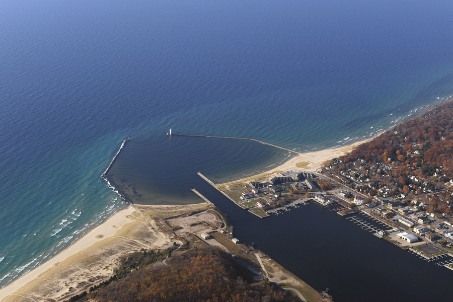
Navigation Structures at Frankfort Harbor
Monument and historic site · National Register of Historic Places · 0.9 mi
Navigation structures in Michigan, United States
Elberta Life Saving Station
Monument and historic site · 0.6 mi
The Life Saving Station in Elberta, Michigan is available for rental. Popular as a great all-in-one wedding and reception venue, the...
1120 Furnace Street, Elberta

Oliver Art Center
Museum · 0.7 mi
Three floors with two exhibition galleries, three spacious classrooms, a demonstration kitchen, office space, storage and artwork...
132 Coast Guard Road, Frankfort
1 more on the map.
Parks, trails and playgrounds19





7 more on the map.
Restaurants and cafes10


Kilwins
Restaurant · Chocolate, Ice Cream, Popcorn · 0.5 mi
413 Main Street, Frankfort





History
Father Jacques Marquette, one of the first Jesuit missionaries to the Great Lakes Indians, may have died and been buried in Frankfort in May 1675. Very limited and inexact records make the death site a matter of considerable debate among historians. Frankfort is one of two locations attributed as the death site by the natives since the earliest settlers arrived in northern Michigan and one of at least two sites claimed by historians. In any case within two years the remains were taken to the church at St. Ignace and given a traditional Indian burial.
From the History section of Frankfort, Michigan on Wikipedia, under CC BY-SA 4.0.
Where to stay2
Churches and places of worship6
Shopping1
Gas and EV charging1
Schools, colleges and libraries4
Healthcare2
Map of Frankfort
63 places. The map loads OpenStreetMap tiles when you open it.
Climate by month
Monthly table
| Month | High | Low | Rain | Snow |
|---|---|---|---|---|
| Jan | 29°F | 18°F | 2.2 in | 27.2 in |
| Feb | 31°F | 19°F | 1.7 in | 19.4 in |
| Mar | 40°F | 25°F | 2.0 in | 12.8 in |
| Apr | 52°F | 35°F | 3.1 in | 3.3 in |
| May | 64°F | 45°F | 3.1 in | 0.1 in |
| Jun | 73°F | 55°F | 3.2 in | 0.0 in |
| Jul | 77°F | 60°F | 3.0 in | 0.0 in |
| Aug | 76°F | 60°F | 3.2 in | 0.0 in |
| Sep | 69°F | 54°F | 3.8 in | 0.0 in |
| Oct | 56°F | 43°F | 4.0 in | 0.3 in |
| Nov | 44°F | 33°F | 2.9 in | 6.4 in |
| Dec | 34°F | 24°F | 2.2 in | 23.5 in |
U.S. Climate Normals 1991-2020 for Frankfort 2Ne (1 mi away), NOAA NCEI.
People and cost of living
American Community Survey 5-year estimates, 2020-2024, U.S. Census Bureau. Estimates have margins of error, larger for small towns.
Disaster history
Benzie County has had 4 federal disaster declarations since 2000, most often for biologicals.
- 2026-06-30: Severe Storms, Tornadoes, And Flooding (Flood)
- 2020-03-27: Covid-19 Pandemic (Biological)
- 2020-03-13: Covid-19 (Biological)
- 2005-09-07: Hurricane Katrina Evacuation (Hurricane)
OpenFEMA disaster declarations summaries.
Getting there and nearby towns
Manistee County-Blacker Airport (MBL) is the nearest airport with scheduled flights listed in OpenStreetMap, 25 miles away.
- Benzonia 7 mi east, about 11 min by car
- Empire 15 mi northeast, about 24 min by car
- Thompsonville 17 mi southeast, about 27 min by car
- Onekama 19 mi south, about 30 min by car
- Chums Corner 28 mi east, about 46 min by car
- Traverse City 32 mi east, about 51 min by car
- Elk Rapids 44 mi northeast, about 1 h 15 min by car
- Cadillac 48 mi southeast, about 1 h 15 min by car
- Baldwin 54 mi south, about 1 h 30 min by car
- Bellaire 56 mi northeast, about 1 h 30 min by car
Drive times are estimates from straight-line distance, not routes.
Local news
Headlines from INDB, the NEMICO news database.
Reviews, tips and questions
Loading what members have shared...
Sources and licences
- NCES EDGE (Public domain): public schools
- NOAA NCEI U.S. Climate Normals 1991-2020 (Public domain): climate by month
- OpenFEMA (Public domain): disaster declarations
- OpenStreetMap contributors (ODbL 1.0): places, airports, map data
- U.S. Census Bureau (Public domain): population, income, housing, education, commute
- Wikidata (CC0 1.0): elevation, founding date, time zone, website, landmarks and historic places
- Wikimedia Commons (see each image): photos
- Wikipedia (CC BY-SA 4.0): overview and history text
Photo credits
- Market Square Park 2019 May 18 Frankfort, Michigan, Gpwitteveen, CC BY-SA 4.0
- Sunset at Frankfort lighthouse (3289227101), daBinsi, CC BY 2.0
- Frankfort Land Co. House, rossograph, CC BY-SA 3.0
- 19970724 12 City of Milwaukee boat at Frankfort, Michigan (5898474704), David Wilson from Oak Park, Illinois, USA, CC BY 2.0
- 19970724 13 Frankfort, Michigan (5898474764), David Wilson from Oak Park, Illinois, USA, CC BY 2.0
- Frankfort, MI, TCP04, CC BY 4.0
- Over looking Frankfort - panoramio, papadakp, CC BY-SA 3.0
- Over looking Frankfort - panoramio (1), papadakp, CC BY-SA 3.0
- Frankfort Light, TCP04, CC BY 4.0
- Frankfort Lighthouse IMG 2776 (4674091249), Tom Page from London, UK, CC BY-SA 2.0
- Frankfort Lighthouse (5917064741), Kari from Denver, CO, United States, CC BY 2.0
- Frankfort Light - US-MI 2010, Jim Sorbie, CC BY 2.0
- Frankfort Harbor 2, US Army Corps of Engineers, Detroit District, Public domain
- Michigan life saving station 01, Ken Bosma from Green Valley, Arizona, USA, CC BY 2.0
- Lighthouse 140316 9260 (13527352525), Jim Sorbie, CC BY 2.0
- 100725 0757B (4885349107), Jim Sorbie, CC BY 2.0
- 20191016-DSC 1607 (48977707042), Jim Sorbie, CC BY 2.0
- 20180921-DSC 3193-1 - Flickr - Jim Sorbie, Jim Sorbie, CC BY 2.0
- Lighthouse 100109 7208 (4263644174), Jim Sorbie, CC BY 2.0
- 20191016-DSC 1568 (48977703597), Jim Sorbie, CC BY 2.0
- 20201101-DSC 4909 (50560980952), Jim Sorbie, CC BY 2.0
- 20201101-DSC 5007 (50560867191), Jim Sorbie, CC BY 2.0
- Bye Street Lookout - panoramio (1), papadakp, CC BY-SA 3.0
- Bye Street Lookout - panoramio (2), papadakp, CC BY-SA 3.0
- Bye Street Lookout - panoramio, papadakp, CC BY-SA 3.0
- Bye St lookout - panoramio, papadakp, CC BY-SA 3.0
- DSC 6351 (1795923306), Jim Sorbie, CC BY 2.0
- Lapland Longspur (first of fall), Elberta Beach, 21 September 2013 (9900143406), Caleb Putnam, CC BY-SA 2.0
- Sunset Elberta MI. - panoramio, hangout, CC BY-SA 3.0
- Elberta, MI, TCP04, CC BY 4.0


Page built October 30, 2026. Spotted a mistake? Tell us or suggest a place.