


Franklin, Ohio
Franklin is a city of 11,712 people in Warren County, Ohio, founded in 1796.
Why visit Franklin
Townapedia lists 5 museums and landmarks, 11 parks and trails, 42 places to eat, 5 places to stay and 3 attractions in and around town.
Highlights include La Comedia Dinner Theatre, Miami University Middletown, Charles Butler House and Dr. Aaron Wright House.
July is the warmest month, with average highs of 86°F; January lows average 20°F.
Weather in Franklin
Forecast from the National Weather Service. Full forecast
About Franklin
Franklin is a city in Warren County, Ohio, United States, along the Great Miami River. The population was 11,690 at the 2020 census. The city lies about 15 miles (24 km) southwest of Dayton and 33.5 miles (53.9 km) northeast of Cincinnati. Ohio State Routes 73, 123 and 741 pass through Franklin, while Interstate 75 is routed to the east side of the city.
From the Wikipedia article Franklin, Ohio (this version), under CC BY-SA 4.0.
Things to do3

La Comedia Dinner Theatre
Cinema and theater · 2.0 mi
Dinner theater in Cincinnati, Ohio, United States
765 West Central Avenue, Springboro

Miami University Middletown
School · 3.8 mi
Regional Public college in Middletown, Ohio, United States

Museums and landmarks5

Charles Butler House
Monument and historic site · National Register of Historic Places · 0.7 mi
Historic house in Franklin, Ohio, United States

Dr. Aaron Wright House
Monument and historic site · National Register of Historic Places · 3.1 mi
Historic house in Ohio, United States
Mackinaw Historic District
Monument and historic site · National Register of Historic Places · 0.9 mi
Historic residential area located on the western side of the Great Miami River in Franklin, Ohio

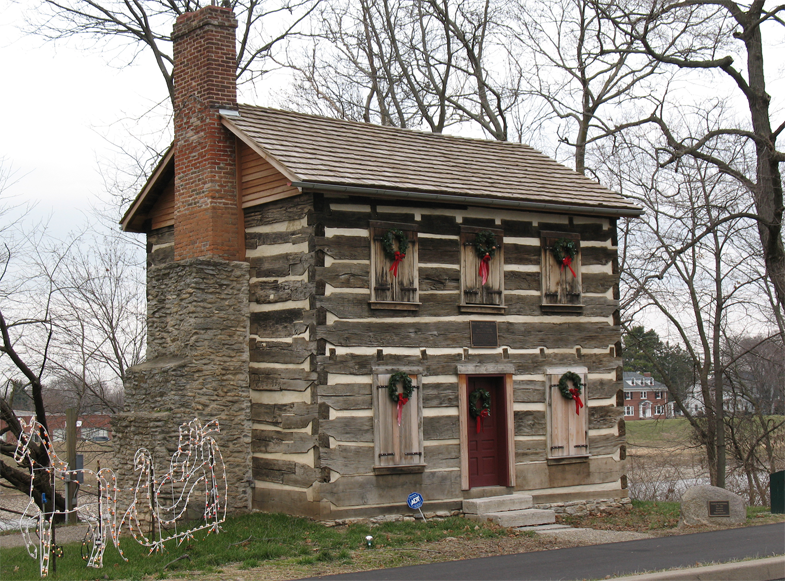
Old Log Post Office
Museum · National Register of Historic Places · 0.7 mi
Post office established April 1, 1805 located in Franklin, Ohio, USA


Springboro Historic District
Monument and historic site · National Register of Historic Places · 3.4 mi
Historic district in Ohio, United States
Parks, trails and playgrounds11


Restaurants and cafes42

Pisanello's Pizza
Restaurant · Pizza · 0.6 mi
355 South Main Street, Franklin
Mo-Th 10:30-20:00; Fr 10:30-21:00; Sa 10:30-20:00

The Purple Pig Cafe
Cafe · Coffee Shop, Sandwich · 1.3 mi
751 Dayton–Oxford Road, Carlisle
Mo-Fr 07:00-15:00, Sa 07:00-14:00

Tim Hortons
Cafe · Coffee Shop · 1.8 mi
894 West Central Avenue, Springboro
Mo-We 05:00-19:00; Fr-Sa 05:00-19:00; Su 05:00-17:00
30 more on the map.
History
Franklin was founded by General William C. Schenck, in 1796. The settlement was named for Benjamin Franklin. Franklin was incorporated in 1814, and became a city in 1951. One of the first four post offices in Warren County was established in Franklin in 1805. The first postmaster was John N.C. Schenck, brother of General Schenck. The Franklin Post Office still stands (in a different location), and is one of four sites in Franklin listed on the National Register of Historic Places, along with the Mackinaw Historic District.
Construction of the Miami and Erie Canal occurred between 1825 and 1845. The canal followed the Great Miami River through Franklin, and the boat traffic led to new commerce. The town soon had a pork slaughterhouse, barrel making factory, sawmill, and whiskey distillery. Franklin's first mayor, Dr. Absalom Death, was elected at a tavern meeting in 1837. Dr. Death went on to be director of a medical college in Cincinnati. In its history, two doctors in Franklin have been named "Dr. Death".
From the History section of Franklin, Ohio on Wikipedia, under CC BY-SA 4.0.
Where to stay5
Churches and places of worship18
Shopping4
Gas and EV charging15
Schools, colleges and libraries40
Central Academy Nongraded Elementary School
School · 3.9 mi
4601 Sophie Ave, Middletown
Healthcare3
Map of Franklin
146 places. The map loads OpenStreetMap tiles when you open it.
Climate by month
Monthly table
| Month | High | Low | Rain |
|---|---|---|---|
| Jan | 38°F | 20°F | 3.3 in |
| Feb | 42°F | 22°F | 2.5 in |
| Mar | 52°F | 30°F | 3.5 in |
| Apr | 65°F | 39°F | 4.6 in |
| May | 74°F | 51°F | 4.4 in |
| Jun | 82°F | 60°F | 4.5 in |
| Jul | 86°F | 64°F | 4.3 in |
| Aug | 85°F | 61°F | 2.9 in |
| Sep | 79°F | 53°F | 2.9 in |
| Oct | 67°F | 41°F | 3.2 in |
| Nov | 53°F | 32°F | 3.0 in |
| Dec | 42°F | 26°F | 3.2 in |
U.S. Climate Normals 1991-2020 for Franklin (1 mi away), NOAA NCEI.
People and cost of living
American Community Survey 5-year estimates, 2020-2024, U.S. Census Bureau. Estimates have margins of error, larger for small towns.
Disaster history
Warren County has had 8 federal disaster declarations since 2000, most often for severe storms.
- 2020-03-31: Covid-19 Pandemic (Biological)
- 2020-03-13: Covid-19 (Biological)
- 2012-06-30: Severe Storms (Severe Storm)
- 2008-10-24: Severe Wind Storm Associated With Tropical Depression Ike (Severe Storm)
- 2005-09-13: Hurricane Katrina Evacuation (Hurricane)
- 2005-02-15: Severe Winter Storms, Flooding, And Mudslides (Severe Storm)
OpenFEMA disaster declarations summaries.
Getting there and nearby towns
Dayton–Wright Brothers Airport (MGY) is the nearest airport with scheduled flights listed in OpenStreetMap, 4 miles away.
- Springboro 3 mi east, about 5 min by car
- Middletown 5 mi southwest, about 8 min by car
- Miamisburg 5 mi north, about 9 min by car
- Monroe 8 mi southwest, about 13 min by car
- West Carrollton 8 mi north, about 13 min by car
- Centerville 10 mi northeast, about 16 min by car
- Lebanon 10 mi southeast, about 16 min by car
- Trenton 11 mi southwest, about 17 min by car
- Kettering 12 mi northeast, about 20 min by car
- Mason 13 mi south, about 22 min by car
Drive times are estimates from straight-line distance, not routes.
Local news
Headlines from INDB, the NEMICO news database.
Reviews, tips and questions
Loading what members have shared...
Sources and licences
- NCES EDGE (Public domain): public schools
- NOAA NCEI U.S. Climate Normals 1991-2020 (Public domain): climate by month
- OpenFEMA (Public domain): disaster declarations
- OpenStreetMap contributors (ODbL 1.0): places, airports, map data
- U.S. Census Bureau (Public domain): population, income, housing, education, commute
- Wikidata (CC0 1.0): elevation, founding date, time zone, website, landmarks and historic places
- Wikimedia Commons (see each image): photos
- Wikipedia (CC BY-SA 4.0): overview and history text
Photo credits
- Franklin OH Old PO, Mfields1 at en.wikipedia, CC BY-SA 3.0
- Franklin First United Methodist Church, Harpland, CC BY-SA 4.0
- Franklin, OH 45005, USA - panoramio (cropped), F Conrad, CC BY-SA 3.0
- Franklin, OH 45005, USA - panoramio, F Conrad, CC BY-SA 3.0
- Charles Butler House in Franklin, Nyttend, Public domain
- 1st Street trailhead, Great Miami River Recreational Trail, Franklin, Ohio, John Beagle, CC BY 2.0
- Dr Aaron Wright House Springboro OH USA, Ed! (talk) (Hall of Fame), CC BY-SA 3.0
- Springboro Historic District Springboro OH USA, Ed! (talk) (Hall of Fame), CC BY-SA 3.0
- La Comedia Springboro OH USA, Ed! (talk) (Hall of Fame), CC BY-SA 3.0
- Eden Thirkfield Home, Harpland, CC BY-SA 4.0
- Mackinaw Historic District, Nyttend, Public domain
- JoeBlystone, Rlipps, CC BY-SA 4.0
- Hill-Kinder Mound from southwest, Nyttend, Public domain
- Carlisle Schools 12 August 2022, Mcginley1, CC BY-SA 4.0
- Carlisle Local Schools 12 August 2022, Mcginley1, CC BY-SA 4.0
- Henry Decker Farmhouse, Nyttend, Public domain


Page built October 30, 2026. Spotted a mistake? Tell us or suggest a place.